Until Proven Safe

[Image: Dressed in 21st-century personal protective equipment (PPE), I am standing next to Dr. Luigi Bertinato, wearing period plague doctor gear from the time of the Black Death, inside the library of the Querini Stampalia, Venice. Photo by Nicola Twilley.]

Long-time readers of this blog will hardly be surprised to hear of my interest in quarantine, a topic I’ve been posting and lecturing about since at least 2009. The Landscapes of Quarantine exhibition at Storefront for Art and Architecture, curated with Nicola Twilley back in 2010, was the beginning of a much larger project that we eventually returned to, several years ago, for a book on the subject.

Originally titled—and sold to our editor as—The Coming Quarantine, we had to change the book’s name when COVID-19 hit. Surreally, we ended up finishing a book about quarantine while in a state of medical detention—indeed, at one point late last spring, more than half the world’s human population was in some state of quarantine or lockdown.

Our book’s hypothesis and prediction was, in fact, that we would all be quarantining more in the future, not less, relying on this seemingly medieval tool of spatial isolation to protect ourselves from emerging diseases for which we had no natural immunity, no available vaccination, and no cure. Why quarantine? It is the use of space and time to overcome uncertainty, creating a buffer between ourselves and a potentially infectious other until that suspected threat can be proven safe.

[Image: An arch inside the abandoned lazaretto, or quarantine hospital, on Manoel Island, Malta; photo by Geoff Manaugh.]

Until Proven Safe: The History and Future of Quarantine—the book we have been traveling for, reporting, and working on since summer 2016—finally comes out tomorrow, July 20th. I am unbelievably excited about this book, for millions of reasons. On one level, it combines so many of the long-running interests here on this blog, from quarantine itself to architectural ruins, mythology & horror, science fiction, space exploration, the Army Corps of Engineers, agricultural landscapes, strange animal diseases, extraordinary engineering controls, the ethical dangers of smart homes, even nuclear waste.

Having posted little to nothing about this book over the past few years—indeed, having posted almost nothing about COVID-19—it’s also immensely relieving to finally release this thing into the world.

[Image: Inside the lazaretto at Ancona, Italy; photo by Geoff Manaugh.]

Some highlights that I think would appeal to BLDGBLOG readers include Nicky’s and my travelogue around the Adriatic and Mediterranean seas, exploring ruined lazarettos in the footsteps of 18th-century British prison reformer—and quarantine critic—John Howard. We climbed locked fences into ruins on Malta, took a night ship across the Adriatic to disembark near the extraordinary pentagonal lazaretto in Ancona, and we got to tour the then-closed Lazzaretto Nuovo in Venice, Italy, with the local man intent on preserving it. (His original plan, he admitted, was to turn the island into a martial arts dojo.)

In other parts of the book, we sit down with the head of the Disinfected Mail Study Circle, based in North London. That group collects rare pieces of mail sent to and from sites of quarantine; like characters in a Thomas Pynchon novel, their postal archaeology has revealed previously forgotten outbreaks and odd geopolitical details about the formation of international borders.

We also visited the first federal quarantine facility, then under construction, in the United States in more than a hundred years, mere months before COVID-19, and we spoke with the former head of the Army Corps of Engineers about plans for retrofitting hotels, convention centers, and stadiums, as well as the prospect of pop-up home quarantine kits in the near-future. We visited the Ebola high-level isolation unit at the Royal Free Hospital in London—where Nicky climbed inside.

[Image: Nicola Twilley inside the high-level isolation unit’s Trexler Ebola system; photo by Geoff Manaugh.]

In the latter half of the book—primarily dedicated to nonhuman quarantine, or quarantine applied to the plant, animal, and mineral kingdoms, capped off by a look at “planetary protection” and the risk of alien microbes—we were able to see a brand-new high-level animal-disease research lab in the middle of U.S. cattle country. This is the nation’s replacement for the aging facility on Plum Island, subject of countless conspiracy theories.

Elsewhere, we went deep into WIPP—the Waste Isolation Pilot Plant—outside Carlsbad, New Mexico, to see nuclear waste being buried and isolated from the Earth’s biosphere for a federally-mandated time periods of at least 100,000 years. We got to see the Apollo moon rocks and learn about the history of lunar quarantine, and even sat down with two of NASA’s Planetary Protection Officers—and their counterpart at the European Space Agency—to discuss the quarantine challenge of bringing Mars geology back to Earth. Along the way, we got to see Perseverance, the Mars rover, before its long (and successful) journey to Mars.

[Image: Walking inside the Waste Isolation Pilot Plant, a salt mine 2,150 feet below the surface of the Earth, where the United States is permanently burying nuclear waste; photo by Nicola Twilley.]

Reporting the book also led us to a series of high-level pandemic simulations over the course of several years—all the way up to the incredible experience of sitting in on a simulation in October 2019, the premise of which was a global outbreak of a novel coronavirus. As we sat there, listening to government figures role-play what they would do, the very earliest cases of COVID-19 were likely circulating in China, undetected.

We also look at the limits of mathematical modeling, the encroachment of algorithms and Big Data into the future of quarantine, and the dystopian potential of involuntary medical isolation automatically enforced by today’s smart homes.

And, through all of that, one of our biggest coups, I think, was recording hours of interviews with the head of the CDC’s division of global migration and quarantine, visiting him in his office at the CDC and recording anguished, on-the-record discussions during the Trump Administration about the nation’s COVID-19 response.

A great way to get a flavor of the book would be to check out excerpts published in WIRED and The Guardian—and, tomorrow morning, The Atlantic—or to listen to the Gastropod episode we did on quarantine, agriculture, and threats to the world’s chocolate supply.

[Image: Until Proven Safe, with a cover design by Alex Merto.]

If you’re tempted, you can order a copy from Bookshop, Indiebound, Amazon, Barnes & Noble, or your local independent bookshop, etc. etc.

Note: This post contains affiliate links to Amazon and Bookshop from which I might draw a small percentage of any book sales.

Building Digital with Timber, Mud, and Ice

[Image: From a project called “Slice” by HANNAH, as featured in FABRICATE 2020.]

The Bartlett School of Architecture recently put out two new books, freely available for download, FABRICATE 2020 and Design Transactions. Check them both out, as each is filled with incredibly interesting and innovative work.

Purely in the interests of time—by all means, download the books and dive in—I’ll focus on three projects rethinking the use of wood, clay, and ice, respectively, alongside new kinds of concrete formwork and 3D printing.

[Image: From “Slice” by HANNAH, as featured in FABRICATE 2020.]

For a project called “Slice,” Sasa Zivkovic and Leslie Lok of design firm HANNAH and Cornell University explore the use of “waste wood” killed by Emerald Ash Borer infestation.

[Image: From “Slice” by HANNAH, as featured in FABRICATE 2020.]

“Mature ash trees with irregular geometries present an enormous untapped material resource. Through high-precision 3D scanning and robotic fabrication on a custom platform, this project aims to demonstrate that such trees constitute a valuable resource and present architectural opportunities,” they explain.

[Images: From “Slice” by HANNAH, as featured in FABRICATE 2020.]

They continue on their website: “No longer bound to the paradigm of industrial standardization, this project revisits bygone wood craft and design based on organic, found and living materials. Robotic bandsaw cutting is paired with high-precision 3D scanning to slice bent logs from ash trees that are infested by the Emerald Ash Borer.”

I’m reminded of a point made by my wife, Nicola Twilley, in an article for The New Yorker last year about fighting wildfires in California. At one point, she describes attempts “to imagine the outlines of a timber industry built around small trees, rather than the big trees that lumber companies love but the forest can’t spare. In Europe, small-diameter wood is commonly compressed into an engineered product called cross-laminated timber, which is strong enough to be used in multistory structures.”

Seeing HANNAH’s work, it seems that perhaps another way to unlock the potential of small-diameter wood is through robotic bandsaw slicing.

[Image: From “Mud Frontiers” by Emerging Objects, as featured in FABRICATE 2020.]

For their project “Mud Frontiers,” Ronald Rael and Virginia San Fratello use 3D printing and “traditional materials (clay, water, and wheat straw), to push the boundaries of sustainable and ecological construction in a two phase project that explores traditional clay craft at the scale of architecture and pottery.”

[Image: From “Mud Frontiers” by Emerging Objects.]

“To do this,” they explain on their website, “we stepped out of the gallery and into the natural environment by constructing a low-cost, and portable robot, designed to be carried into a site where local soils could be harvested and used immediately to 3D print large scale structures.”

[Image: From “Mud Frontiers” by Emerging Objects.]

Finally—and, again, I would recommend just downloading the books and spending time with each, as I am barely scratching the surface here—we have a very cool project looking at “ice formwork” for concrete, developed by Vasily Sitnikov at the KTH Royal Institute of Technology in Stockholm.

[Image: Ice formwork for casting concrete, developed by Vasily Sitnikov, as featured in Design Transactions.]

Sitnikov’s method was initially devised as a way to save energy during the concrete-casting and construction process, but quickly revealed its own aesthetic and structural implications: “The variety of programmable functions for ice formwork is vast,” he writes, “across environmental design, programmable lighting conditions, acoustics, ventilation, insulation and structural-design weight-saving applications.”

[Image: Ice formwork for casting concrete, developed by Vasily Sitnikov.]

He has found, for example, that “spatial patterns… can be imposed on concrete, abandoning any use of petrochemicals in the fabrication process. Breaking away from the ‘solid’ image of conventional concrete, the technique of using ice as the formwork material enables the production of mesoscale spatial structures in concrete which would be impossible to manufacture with existing formwork materials.”

[Image: Ice formwork for casting concrete, developed by Vasily Sitnikov.]

Weaving, carving, cutting, molding: the two new Bartlett books have much, much more, including voluminous detail about each of the projects mentioned briefly above, so click on through and go wild: Design Transactions and FABRICATE 2020.

Great Basin Autoglyphs

[Image: Michael Light, from “Great Basin Autoglyphs and Pleistoseas”].

A new exhibition of work by photographer Michael Light opened last night at the Hosfelt Gallery in San Francisco.

[Image: Michael Light, from “Great Basin Autoglyphs and Pleistoseas”].

Called “Great Basin Autoglyphs and Pleistoseas,” the work is part of an “ongoing aerial photographic survey of the arid American West… moving from habited, placed settlements into pure space and its attendant emptiness.”

[Image: Michael Light, from “Great Basin Autoglyphs and Pleistoseas”].

Along the way, Light reframes human civilization as a series of abstract lines inscribed at vast scale through remote areas, less like infrastructure and more like planetary graffiti.

“Twelve thousand years ago,” Light writes, “the Great Basin—that part of the country between California and Utah where water does not drain to the ocean—was 900 feet underwater, covered by two vast and now largely evaporated historical lakes, Bonneville and Lahontan. The remnants of Lake Bonneville today are the Great Salt Lake in Utah and its eponymous salt flats, while the most famous portion of the former Lake Lahontan is the Black Rock Desert in Nevada, an alkali bed that floods and dries each year, creating the flattest land on earth.”

[Image: Michael Light, from “Great Basin Autoglyphs and Pleistoseas”].

Light is an incredibly interesting photographer, and has done everything from wreck-diving old military ships scuttled during nuclear weapons tests in the South Pacific to releasing a book of retouched archival photos from the Apollo Program.

Nicola Twilley and I interviewed Light several years ago for our Venue project, where we discussed these projects at length.

[Image: Michael Light, from “Great Basin Autoglyphs and Pleistoseas”].

In you’re near San Francisco, stop by the Hosfelt Gallery before March 16, 2019, and also consider ordering a copy of Light’s forthcoming book, Lake Lahontan/Lake Bonneville, with related images.

Under the Dome

[Image: Courtesy U.S. Department of the Interior Bureau of Ocean Energy Management (BOEM)].

A gigapixel bathymetric map of the Gulf of Mexico’s seabed has been released, and it’s incredible. The newly achieved level of detail is almost hard to believe.

[Images: Courtesy U.S. Department of the Interior Bureau of Ocean Energy Management (BOEM)].

The geology of the region is “driven not by plate tectonics but by the movement of subsurface bodies of salt,” Eos reported last week. “Salt deposits, a remnant of an ocean that existed some 200 million years ago, behave in a certain way when overlain by heavy sediments. They compact, deform, squeeze into cracks, and balloon into overlying material.”

This means that the bottom of the Gulf of Mexico “is a terrain continually in flux.”

How the salt got there is the subject of a long but fascinating description at Eos.

It is hypothesized that the salt precipitated out of hypersaline seawater when Africa and South America pulled away from North America during the Triassic and Jurassic, some 200 million years ago. The [Gulf of Mexico] was initially an enclosed, restricted basin into which seawater infiltrated and then evaporated in an arid climate, causing the hypersalinity (similar to what happened in the Great Salt Lake in Utah and the Dead Sea between Israel and Jordan).

Salt filled the basin to depths of thousands of meters until it was opened to the ancestral Atlantic Ocean and consequently regained open marine circulation and normal salinities. As geologic time progressed, river deltas and marine microfossils deposited thousands more meters of sediments into the basin, atop the thick layer of salt.

The salt, subjected to the immense pressure and heat of being buried kilometers deep, deformed like putty over time, oozing upward toward the seafloor. The moving salt fractured and faulted the overlying brittle sediments, in turn creating natural pathways for deep oil and gas to seep upward through the cracks and form reservoirs within shallower geologic layers.

These otherwise invisible landscape features “oozing upward” from beneath the seabed are known as salt domes, and they are not only found at the bottom of the Gulf of Mexico.

[Image: Avery Island, Louisiana, archived by the U.S. Library of Congress].

The black and white photos you see here are from a salt mine on Avery Island, Louisiana, archived by the U.S. Library of Congress. The photos date back as far as 1900, and they’re gorgeous.

[Image: Avery Island, Louisiana, archived by the U.S. Library of Congress].

This is what it looks like inside those salt domes, you might way, once industrially equipped human beings have carved wormlike topological spaces into the deformed, ballooning salt deposits of the region.

[Image: Avery Island, Louisiana, archived by the U.S. Library of Congress].

Obviously, the Gulf of Mexico is not the only salt-rich region of the United States; there is a huge salt mine beneath the city of Detroit, for example, and the nation’s first nuclear waste repository, the Waste Isolation Pilot Plant, or WIPP—which my wife and I had the surreal pleasure of visiting in person back in 2012—is dug into a huge underground salt deposit near the New Mexico/Texas border.

[Image: Inside WIPP; photo by Nicola Twilley].

Nonetheless, the Louisiana/Gulf of Mexico salt dome region has lent itself to some particularly provocative landscape myths.

You might recall, for example, the story of Lake Peigneur, an inland body of water that was almost entirely drained from below when a Texaco drilling rig accidentally punctured a salt dome beneath the lake.

This led to the sight of a rapid, Edgar Allan Poe-like maelström of swirling water disappearing into the abyss, pulling no fewer than eleven barges into the terrestrial deep.

[Image: Avery Island, Louisiana, archived by the U.S. Library of Congress].

But there is also the story of Bayou Corne, one of my favorite conspiracy theories of all time.

[Images: Avery Island, Louisiana, archived by the U.S. Library of Congress].

As the New York Times reported back in 2013, “in the predawn blackness of Aug. 3, 2012, the earth opened up—a voracious maw 325 feet across and hundreds of feet deep, swallowing 100-foot trees, guzzling water from adjacent swamps and belching methane from a thousand feet or more beneath the surface.”

One resident of the area is quoted as saying, “I think I caught a glimpse of hell in it.”

More than a year after it appeared, the Bayou Corne sinkhole is about 25 acres and still growing, almost as big as 20 football fields, lazily biting off chunks of forest and creeping hungrily toward an earthen berm built to contain its oily waters. It has its own Facebook page and its own groupies, conspiracy theorists who insist the pit is somehow linked to the Gulf of Mexico 50 miles south and the earthquake-prone New Madrid fault 450 miles north. It has confounded geologists who have struggled to explain this scar in the earth.

To oversimplify things, the overall theory—that is, the conspiratorial part of all this—is that the entire landscape of the Gulf region is on the verge of subterranean dissolution. The very salt deposits so beautifully mapped by the Bureau of Ocean Energy Management are all lined up for eventual flooding.

As this vast underground landscape of salt dissolves, everything from east Texas to west Florida will be sucked down into the abyss.

[Image: Avery Island, Louisiana, archived by the U.S. Library of Congress].

It’s unlikely that this will happen, I should say. You can sleep well at night.

In the meantime, the sorts of salt-mining operations depicted here in these photographs have carved their worming, subterranean way into the warped terrains of salt that dynamically ooze their way up to the surface from geological prehistory.

[Image: Avery Island, Louisiana, archived by the U.S. Library of Congress].

Be sure to check out the full gigapixel BOEM map, and the helpful write-up over at Eos is worth a read, as well. As for the Bayou Corne conspiracy—I suppose we’ll just have to wait.

(Bathymetric maps spotted via Chris Rowan; salt mine photos originally spotted a very long time ago via Attila Nagy).

Supersensory Substitution Technology

[Image: “Animal Superpowers” by Chris Woebken and Kenichi Okada].

I’m biased, but my wife, Nicola Twilley, had a great feature in The New Yorker’s “Innovation” issue earlier this month, about an emerging type of device known as “sensory-substitution technology.”

For the piece, Nicky met a man named Erik Weihenmayer, a congenitally blind mountain climber—in fact, he is “the only blind person to have climbed Mt. Everest.” Weihenmayer climbs using a device called the BrainPort, held in his mouth; it converts one sense (sight) to another (touch).

A decade ago, Weihenmayer began using the BrainPort, a device that enables him to “see” the rock face using his tongue. The BrainPort consists of two parts: the band on his brow supports a tiny video camera; connected to this by a cable is a postage-stamp-size white plastic lollipop, which he holds in his mouth. The camera feed is reduced in resolution to a grid of four hundred gray-scale pixels, transmitted to his tongue via a corresponding grid of four hundred tiny electrodes on the lollipop. Dark pixels provide a strong shock; lighter pixels merely tingle. The resulting vision is a sensation that Weihenmayer describes as “pictures being painted with tiny bubbles.”

What’s particularly interesting, however, is that these are still just the earliest days of investment and research into what sensory-substitution devices might someday be able to achieve.

They could lead, for example, to the creation of artificial “superabilities,” or synthetic senses that act as a mix between our existing bodily inputs. Through the use of these sorts of devices, Nicky writes, humans “may, depending on the data transmitted through their skin, be able to ‘feel’ electromagnetic fields, stock-market data, or even space weather,” or “enable us to ‘see’ bodies through walls using the infrared spectrum or to ‘hear’ the location of family members using G.P.S. tracking technology.”

I suppose the next question would be to imagine a world in which this is possible—humans feeling space weather or seeing bodies through walls—and then to design the landscape accordingly. Stage sets in which people moving behind walls is part of the action, or outdoor gardens and parks tingling with the pinprick stimulation of otherwise invisible solar flares. Financial analysts high on the fumes of laser printers sit pensively in a dark room feeling stock market data wash over their arms and faces.

Recall, of course, the “Animal Superpowers” project by Chris Woebken and Kenichi Okada, that allowed human users to “see” the world through the senses of animals, one example of which is pictured above.

Read more at The New Yorker.

Devotional Speleology

[Images: Photo by BLDGBLOG].

I’ve been traveling around London, the Adriatic, and the Mediterranean Sea the past few weeks, doing research for a new book, and thus not really using the internet outside of a bunch of Instagram shots; nonetheless, I thought I’d post some pictures from the trip.

Here, above, is Nicola Twilley peering into an old devotional cave dwelling on the Marjan peninsula outside Split, Croatia.

[Image: Photo by BLDGBLOG].

The hermitage is up in a cliff behind a church dedicated to St. Jerome, and the whole complex apparently dates back to the 15th century.

The church itself is also quite picturesque among the trees, with a nearly panoramic view of the Adriatic.

See many more general travel shots on Instagram.

The Burglar’s Guide Has Arrived

At long last, after more than three years of research and travel, A Burglar’s Guide to the City is finally shipping.

burglarsboxes
It is a book about crime, policing, and the built environment, and how these forces mutually influence one another, from ancient Rome to contemporary Los Angeles, with a specific focus on the spatial peculiarities of breaking and entering.

I’ve already posted about the book at some length here on the blog—with many more posts available under the Burglar’s Guide tag—and there is also a standalone website worth checking out, as well, with links to reviews, book tour information, and some great blurbs.

However, for now, especially if this is the first you’ve heard of it, consider checking out an excerpt from the book over at The New York Times Magazine, an author profile over at the Wall Street Journal, a short segment about burglary and Los Angeles on NPR’s Marketplace, or a great review published in the Los Angeles Times.

There, Annalee Newitz writes that, “Despite its title, Geoff Manaugh’s A Burglar’s Guide to the City won’t teach you how to break into houses. It won’t help you outsmart wily cat burglars with ingenious home alarm systems, either. Instead, it explores something a lot weirder and more interesting: Manaugh argues that burglary is built into the fabric of cities and is an inevitable outgrowth of having architecture in the first place.”

Writing for the Barnes & Noble Review, meanwhile, Sarah Weinman—editor of the recent collection Women Crime Writers: Eight Suspense Novels of the 1940s and 1950s—said that, after reading the book, “my worldview is altered a little bit more, and far for the better, as a result.” Patrick Lyons at VICE found the book “an exhilarating, perspective-shifting read,” and the BBC recommended it as one of their “Ten books to read in April,” calling it “a surprising and fascinating true-crime epic.”

Most fun of all was doing an interview with Gastropod—a podcast about food, science, and history cohosted by my wife, Nicola Twilley, and journalist Cynthia Graber—discussing food heists, potato bombs, fast-food burglaries, and much more.

Amazon chose A Burglar’s Guide as one of their “Best Books of April 2016,” adding that it is a “caper of a book.” *Update: I also got to speak about the book with Curbed for their recently launched podcast, on “why panic rooms are going to outlast the pyramids.”

In any case, I’d be over the moon if you picked up a copy, and I would love to discuss the book’s many ideas—and people and tools and scenes and histories—in more detail here. However, I’m also aware that I can’t just post about this book over and over—and over—again, so I’ll also get back to regular blogging soon.

Thanks! And enjoy the book.

A Window “Radically Different From All Previous Windows”

LIGO[Image: The corridors of LIGO, Louisiana, shaped like a “carpenter’s square”; via Google Earth].

It’s been really interesting for the last few weeks to watch as rumors and speculations about the first confirmed detection of gravitational waves have washed over the internet—primarily, at least from my perspective, because my wife, Nicola Twilley, who writes for The New Yorker, has been the only journalist given early access not just to the results but, more importantly, to the scientists behind the experiment, while writing an article that just went live over at The New Yorker.

It has been incredibly exciting to listen-in on partial conversations and snippets of overheard interviews in our home office here, as people like Kip Thorne, Rainer Weiss, and David Reitze, among a dozen others, all explained to her exactly how the gravitational waves were first detected and what it means for our future ability to study and understand the cosmos.

All this gloating as a proud husband aside, however, it’s a truly fascinating story and well worth mentioning here.

LIGO—the Laser Interferometer Gravitational-Wave Observatory—is a virtuoso act of precision construction: a pair of instruments, separated by thousands of miles, used to detect gravitational waves. They are shaped like “carpenter’s squares,” we read, and they stand in surreal, liminal landscapes: surrounded by water-logged swampland in Louisiana and “amid desert sagebrush, tumbleweed, and decommissioned reactors” in Hanford, Washington.

Ligo-Hanford [Image: LIGO, Hanford; via Google Earth].

Each consists of vast, seismically isolated corridors and finely calibrated super-mirrors between which lasers reflect in precise synchrony. These hallways are actually “so long—nearly two and a half miles—that they had to be raised a yard off the ground at each end, to keep them lying flat as Earth curved beneath them.”

To achieve the necessary precision of measurement, [Rainer Weiss, who first proposed the instrument’s construction] suggested using light as a ruler. He imagined putting a laser in the crook of the “L.” It would send a beam down the length of each tube, which a mirror at the other end would reflect back. The speed of light in a vacuum is constant, so as long as the tubes were cleared of air and other particles, the beams would recombine at the crook in synchrony—unless a gravitational wave happened to pass through. In that case, the distance between the mirrors and the laser would change slightly. Since one beam was now covering a shorter distance than its twin, they would no longer be in lockstep by the time they got back. The greater the mismatch, the stronger the wave. Such an instrument would need to be thousands of times more sensitive than any before it, and it would require delicate tuning, in order to extract a signal of vanishing weakness from the planet’s omnipresent din.

LIGO is the most sensitive instrument ever created by human beings, and its near-magical ability to pick up the tiniest tremor in the fabric of spacetime lends it a fantastical air that began to invade the team’s sleep. As Frederick Raab, director of the Hanford instrument, told Nicola, “When these people wake up in the middle of the night dreaming, they’re dreaming about the detector.”

Because of this hyper-sensitivity, its results need to be corrected against everything from minor earthquakes, windstorms, and passing truck traffic to “fluctuations in the power grid,” “distant lightning storms,” and even the howls of prowling wolves.

When the first positive signal came through, the team was actually worried it might not be a gravitational wave at all but “a very large lightning strike in Africa at about the same time.” (They checked; it wasn’t.)

Newton[Image: “Newton” (1795-c.1805) by William Blake, courtesy of the Tate].

The big deal amidst all this is that being able to study gravitational waves is very roughly analogous to the discovery of radio astronomy—where gravitational wave astronomy has the added benefit of opening up an entirely new spectrum of observation. Gravitational waves will let us “see” the fabric of spacetime in a way broadly similar to how we can “see” otherwise invisible radio emissions in deep space.

From The New Yorker:

Virtually all that is known about the universe has come to scientists by way of the electromagnetic spectrum. Four hundred years ago, Galileo began exploring the realm of visible light with his telescope. Since then, astronomers have pushed their instruments further. They have learned to see in radio waves and microwaves, in infrared and ultraviolet, in X-rays and gamma rays, revealing the birth of stars in the Carina Nebula and the eruption of geysers on Saturn’s eighth moon, pinpointing the center of the Milky Way and the locations of Earth-like planets around us. But more than ninety-five per cent of the universe remains imperceptible to traditional astronomy… “This is a completely new kind of telescope,” [David] Reitze said. “And that means we have an entirely new kind of astronomy to explore.”

Interestingly, in fact, my “seeing” metaphor, above, is misguided. As it happens, the gravitational waves studied by LIGO in its current state—ever-larger and more powerful new versions of the instrument are already being planned—“fall within the range of human hearing.”

If you want to hear spacetime, there is an embedded media player over at The New Yorker with a processed snippet of the “chirp” made by the incoming gravitational wave.

In any case, I’ve already gone on at great length, but the article ends with a truly fantastic quote from Kip Thorne. Thorne, of course, achieved minor celebrity last year when he consulted on the physics for Christopher Nolan’s relativistic time-travel film Interstellar, and he is not lacking for imagination.

Thorne compares LIGO to a window (and my inner H.P. Lovecraft reader shuddered at the ensuing metaphor):

“We are opening up a window on the universe so radically different from all previous windows that we are pretty ignorant about what’s going to come through,” Thorne said. “There are just bound to be big surprises.”

Go read the article in full!

The Labyrinth of Night, The Polar Gothic, and a Golden Age for Landscape Studies

It’s hard to resist a place called the Noctis Labyrinthus, or “the Labyrinth of Night,” especially when it’s on Mars.

NoctisLabyrinthus[Image: Courtesy ESA/DLR/FU Berlin].

“This block of martian terrain, etched with an intricate pattern of landslides and wind-blown dunes, is a small segment of a vast labyrinth of valleys, fractures and plateaus,” the European Space Agency reported earlier this week.

“As the crust bulged in the Tharsis province it stretched apart the surrounding terrain, ripping fractures several kilometres deep and leaving blocks—graben—stranded within the resulting trenches,” the ESA adds. “The entire network of graben and fractures spans some 1200 km, about the equivalent length of the river Rhine from the Alps to the North Sea.”

In other words, it’s an absolutely massive expanse of desert canyons and landslides, stretching roughly the distance from Switzerland to Rotterdam—a “700-mile labyrinth of fractures and landslides,” in the words of the reliably interesting Corey Powell on Twitter.

Imagine hiking there.

NoctisLabyrinthusAerial[Image: Courtesy ESA/DLR/FU Berlin].

We are living in something of a golden age for landscape studies. Over a remarkably short span of time, for example, we’ve learned that there are sinkholes on comets—that is, that comets have undergrounds. They have pores, caves, and tunnels, with sinkholes explosively airing this subterranean world into outer space. These “mysterious, steep-sided pits—one up to 600 feet wide and 600 feet deep,” as National Geographic described them, indicate that “there must be gaps inside.” Picture caves and tunnels evaporating in the darkness, before collapsing in on themselves in a crystalline flash.

Meanwhile, I have always loved the fact that there is a mountain range on Mars named after dead American astronauts, as if the Red Planet is somehow haunted in advance of human arrival by the mythological figures of explorers who never made it there. But this is just one small example of how a radically unfamiliar environment can gradually become known through the process of naming.

2016-01-01 22.59.25[Image: From India’s Mars Orbiter, via @coreyspowell].

My wife, Nicola Twilley, was actually at the Johns Hopkins Applied Physics Laboratory for the recent Pluto flyby, covering it for The New Yorker; she wrote a great description of how the former planet became a true landscape:

As the scientists traced tendrils of reddish brown and speculated as to the rate of melt at the edge of a two-toned ice patch near Pluto’s equator, the impossibly distant world came to life. Fed up with referring to features as, for instance, “the black circle at two o’clock” and “the big white patch,” the team had started to give them names—first nicknames, such as “the heart” and “the whale,” and then unofficial but more formal names drawn from the mythology of the underworld. The whale became Lovecraft’s Cthulhu, and a nearby dark smudge was christened Balrog, after the demons of Tolkien’s Middle-earth. An alien landscape had started to become a collection of places: knowable, if not yet known.

Interestingly, it seems that names come first, algorithms later.

In any case, while naming, of course, lends an air of familiarity to alien terrains—or knowability, we might say—the utterly bonkers nature of these landscapes remains extraordinary.

Nicky later revisited the subject, for example, writing that “the reddish patches” seen on Pluto might actually be “the organic material nicknamed ‘star tar,’ a precursor to life”—sludge awaiting sentience—and that “cryovolcanoes—volcanoes that spew slushy methane and nitrogen ice rather than molten rock,” might exist at the planet’s south pole.

There, this slow-moving matrix of frozen elements would circulate amongst other “exotic ices” in the distant cold, surely another kind of “labyrinth of night,” if there ever was one.

Think of what writer Victoria Nelson has called the “polar Gothic,” referring to an era of science-fictional representations of the Earth’s own polar regions as places of psychological menace and theological mystery; now picture weird slurries of nitrogen and star-tar sinkholes in a region named after Cthulhu, and it seems that perhaps the great age of landscape exploration has only now truly begun.

Consider, for example, this tweet by Rob Minchin, referring to the latest geological revelations coming from Pluto, a world of nitrogen glaciers and ice tectonics. “Water ice floats on nitrogen or CO ice,” he explains. This means, unbelievably, that “numerous mountains on Pluto appear to be floating.”

pluto[Image: Pluto, via @CoreySPowell].

Even within our own solar system, it seems, if you have an idea for a landscape so unreal it borders on pure fantasy, there is a planet, comet, or asteroid already exceeding it.

(In addition to @CoreySPowell, another good Twitter account for offworld landscape studies is @LoriKFenton, as the images seen at the link make clear).

Expedition Exhibition

[Image: Venue at SPUR].

For those of you into road trips, nuclear waste, petroglyphs, 19th-century geographic survey teams, remote military simulations, abandoned rocket fuel facilities, Hollow Earth cults, and more, there is only one week left to catch the Venue exhibition over at SPUR in San Francisco.

[Image: Venue at SPUR].

The show documents and looks back at a 16-month collaboration for the Nevada Museum of Art between myself and Edible Geography, collecting not only the special survey instruments we made for the trip with designer Chris Woebken but various ephemera from the travels we picked up along the way.

[Image: Instruments designed by Chris Woebken for Venue].

Over the course of multiple, discontinuous trips throughout the United States—primarily focused on the West—we visited landfills, military bases, nuclear waste disposal sites, atomic clocks, underground neutrino detectors, the world’s largest organism in the mountains of eastern Oregon, the factory where AstroTurf is made, NASA’s “Mars Yard” in Pasadena, the awesomely eccentric Mercer Museum, an elevator-testing tower, the Central Park bolt, a Navy SEAL museum, and a subterranean radon health spa, to name only a handful.

[Image: Venue at SPUR].

Along the way, we interviewed novelists, National Park Service curators, speleobiologists, artists, game designers, the makers of monsters, historians of light pollution, archivists, aerial photographers, and more.

[Images: Venue at SPUR].

The exhibition closes next week, on October 21. Stop by if you can!

In the Box: A Tour Through the Simulated Battlefields of the U.S. National Training Center

[Image: Photo courtesy of Venue].

(This post originally published on Venue).

Fort Irwin is a U.S. army base nearly the size of Rhode Island, located in the Mojave Desert about an hour’s drive northeast of Barstow, California. There you will find the National Training Center, or NTC, at which all U.S. troops, from all services, spend a twenty-one day rotation before they deploy overseas.

[Image: Photo courtesy of Venue].

Sprawling and often infernally hot in the summer months, the base offers free tours, open to the public, twice a month. Venue—BLDGBLOG’s ongoing collaboration with Edible Geography’s Nicola Twilley, supported by the Nevada Museum of Art‘s Center for Art + Environment—made the trip, cameras in hand and notebooks at the ready, to learn more about the simulated battlefields in which imaginary conflicts loop, day after day, without end.
[Images: Photos courtesy of Venue].

Coincidentally, as we explored the Painted Rocks located just outside the gate while waiting for the tour to start, an old acquaintance from Los Angeles—architect and geographer Rick Miller—pulled up in his Prius, also early for the same tour.

[Image: Photo courtesy of Venue].

We laughed, said hello, and caught up about a class Rick had been teaching at UCLA about the military defense of L.A. during World War II, through to the present. An artificial battlefield, beyond even the furthest fringes of Los Angeles, Fort Irwin thus seemed like an appropriate place to meet.

[Image: Photo courtesy of Venue].

We were soon joined by a small group of other visitors—consisting, for the most part, of family members of soldiers deployed on the base, as well as two architecture students from Montréal—before a large white tour bus rolled up across the gravel.

Renita, a former combat videographer who now handles public affairs at Fort Irwin, took our names, IDs, and signatures for reasons of liability (we would be seeing live explosions and simulated gunfire, and there was always the risk that someone might get hurt).

[Image: Photo courtesy of Venue].

The day began with a glimpse into the economics and culture of how a nation prepares its soldiers for war; an orientation, of sorts, before we headed out to visit one of fifteen artificial cities scattered throughout the base.

[Image: Photo courtesy of Venue].

In the plush lecture hall used for “After Action Reviews”—and thus, Renita apologized, air-conditioned to a morgue-like chill in order to keep soldiers awake as their adrenalin levels crash—we received a briefing from the base’s commander, Brigadier General Terry Ferrell.

With pride, Ferrell noted that Fort Irwin is the only place where the U.S. military can train using all of the systems it will later use in theater. The base’s 1,000 square miles of desert is large enough to allow what Ferrell called “great maneuverability”; its airspace is restricted; and its truly remote location ensures an uncluttered electromagnetic spectrum, meaning that troops can practice both collection and jamming. These latter techniques even include interfering with GPS, providing they warn the Federal Aviation Administration in advance.

Oddly, it’s worth noting that Fort Irwin also houses the electromagnetically sensitive Goldstone Deep Space Communications Complex, part of NASA’s global Deep Space Network. As science writer Oliver Morton explains in a paper called “Moonshine and Glue: A Thirteen-Unit Guide to the Extreme Edge of Astrophysics” (PDF), “when digitized battalions slug it out with all the tools of modern warfare, radio, radar, and electronic warfare emissions fly as freely around Fort Irwin as bullets in a battle. For people listening to signals from distant spacecraft on pre-arranged frequency bands, this noise is not too much of a problem.” However, he adds, for other, far more sensitive experiments, “radio interference from the military next door is its biggest headache.”

[Image: Photo courtesy of Venue].

Unusually for the American West, where mineral rights are often transferred separately, the military also owns the ground beneath Fort Irwin, which means that they have carved out an extensive network of tunnels and caves from which to flush pretend insurgents.

This 120-person strong insurgent troop is drawn from the base’s own Blackhorse Regiment, a division of the U.S. Army that exists solely to provide opposition. Whatever the war, the 11th Armored is always the pretend enemy. According to Ferrell, their current role as Afghan rebels is widely envied: they receive specialized training (for example, in building IEDs) and are held to “reduced grooming standards,” while their mission is simply to “stay alive and wreak havoc.”

If they die during a NTC simulation, they have to shave and go back on detail on the base, Ferrell added, so the incentive to evade their American opponents is strong.

[Image: Photo courtesy of Venue].

In addition to the in-house enemy regiment, there is an entire 2,200-person logistics corps dedicated to rotating units in and out of Fort Irwin and equipping them for training. Every ordnance the United States military has, with the exception of biological and chemical weapons, is used during NTC simulations, Ferrell told us. What’s more, in the interests of realism (and expense be damned), troops train using their own equipment, which means that bringing in, for example, the 10th Mountain Division (on rotation during our visit), also means transporting their tanks and helicopters from their home base at Fort Drum, New York, to California, and back again.

Units are deployed to Fort Irwin for twenty-one days, fourteen of which are spent in what Fort Irwin refers to as “The Box” (as in “sandbox”). This is the vast desert training area that includes fifteen simulated towns and the previously mentioned tunnel and caves, as well as expansive gunnery ranges and tank battle arenas.

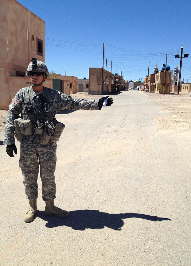
Following our briefing, we headed out to the largest mock village in the complex, the Afghan town of Ertebat Shar, originally known, during its Iraqi incarnation, as Medina Wasl. Before we re-boarded the bus, Renita issued a stern warning: “‘Afghanistan’ is not modernized with plumbing. There are Porta-Johns, but I wanted to let you know the situation before we roll out there.”
[Images: Photos courtesy of Venue].

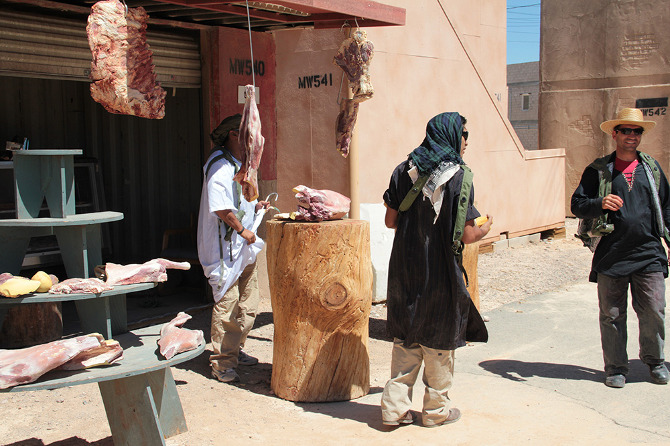
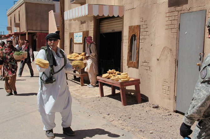
A twenty-minute drive later, through relatively featureless desert, our visit to “Afghanistan” began with a casual walk down the main street, where we were greeted by actors trying to sell us plastic loaves of bread and piles of fake meat. Fort Irwin employs more than 350 civilian role-players, many of whom are of Middle Eastern origin, although Ferrell explained that they are still trying to recruit more Afghans, in order “to provide the texture of the culture.”

The atmosphere is strangely good-natured, which was at least partially amplified by a feeling of mild embarrassment, as the rules of engagement, so to speak, are not immediately clear; you, the visitor, are obviously aware of the fact that these people are paid actors, but it feels distinctly odd to slip into character yourself and pretend that you might want to buy some bread.
[Images: Photos courtesy of Venue].

In fact, it’s impossible not to wonder how peculiar it must be for a refugee, or even a second-generation immigrant, from Iraq or Afghanistan, to pretend to be a baker in a simulated “native” village on a military base in the California desert, only to see tourists in shorts and sunglasses walking through, smiling uncomfortably and taking photos with their phones before strolling away without saying anything.

[Image: Photo courtesy of Venue].

Even more peculiarly, as we reached the end of the street, the market—and all the actors in it—vanished behind us, dispersing back into the fake city, as if only called into being by our presence.

[Image: Photo courtesy of Venue].

By now, with the opening act over, we were stopped in front of the town’s “Lyndon Marcus International Hotel” to take stock of our surroundings. In his earlier briefing, Ferrell had described the simulated villages’ close attention to detail—apparently, the footprint for the village came from actual satellite imagery of Baghdad, in order to accurately recreate street widths, and the step sizes inside buildings are Iraqi, rather than U.S., standard.

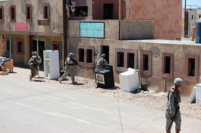
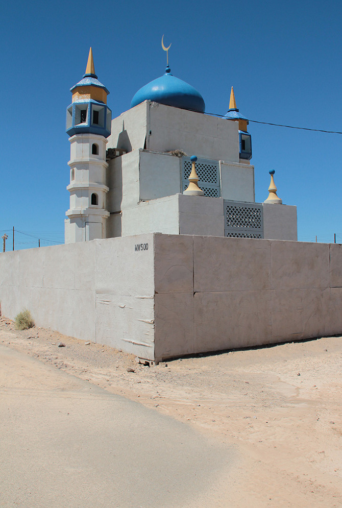
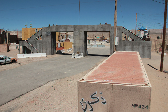
Dimensions notwithstanding, however, this is a city of cargo containers, their Orientalized facades slapped up and plastered on like make-up. Seen from above, the wooden frames of the illusion become visible and it becomes more and more clear that you are on a film set, an immersive theater of war.
[Images: Photos courtesy of Venue].

This kind of test village has a long history in U.S. war planning. As journalist Tom Vanderbilt writes in his book Survival City, “In March 1943, with bombing attacks on cities being intensified by all sides, the U.S. Army Corps of Engineers began construction at Dugway [Utah] on a series of ‘enemy villages,’ detailed reproductions of the typical housing found in the industrial districts of cities in Germany and Japan.”

The point of the villages at Dugway, however, was not to train soldiers in urban warfare—with, for instance, simulated street battles or house-to-house clearances —but simply to test the burn capacity of the structures themselves. What sorts of explosives should the U.S. use? How much damage would result? The attention to architectural detail was simply a subset of this larger, more violent inquiry. As Vanderbilt explains, bombs at Dugway “were tested as to their effectiveness against architecture: How well the bombs penetrated the roofs of buildings (without penetrating too far), where they lodged in the building, and the intensity of the resulting fire.”

During the Cold War, combat moved away from urban settings, and Fort Irwin’s desert sandbox became the stage for massive set-piece tank battles against the “Soviet” Blackhorse Cavalry. But, in 1993, following the embarrassment of the Black Hawk Down incident in Mogadishu, Fort Irwin hosted its first urban warfare, or MOUT (Military Operations on Urbanized Terrain) exercise. This response was part of a growing realization shared amongst the armed forces, national security experts, and military contractors that future wars would again take the city as their battlefield.

[Image: Photo courtesy of Venue].

As Russell W. Glenn of the RAND Corporation puts it bluntly in his report Combat in Hell: A Consideration of Constrained Urban Warfare, “Armed forces are ever more likely to fight in cities as the world becomes increasingly urbanized.”

Massed, professional, and essentially symmetrical armies no longer confront one another on the broad forests and plains of central Europe, the new tactical thinking goes; instead, undeclared combatants living beside—sometimes even with—families in stacked apartment blocks or tight-knit courtyards send out the occasional missile, bullet, or improvised explosive device from a logistically confusing tangle of streets, and “war” becomes the spatial process of determining how to respond.

At Fort Irwin, mock villages began to pop up in the desert. They started out as “sheds bought from Shed World,” Ferrell told us, before being replaced by shipping containers, which, in turn, have been enhanced with stone siding, mosque domes, awnings, and street signs, and, in some cases, even with internal staircases and furniture, too. Indeed, Ertebat Shar/Medina Wasl began its simulated existence in 2007, with just thirteen buildings, but has since expanded to include more than two hundred structures.

The point of these architectural reproductions is no longer, as in the World War II test villages of Dugway, to find better or more efficient methods of architectural destruction; instead, these ersatz buildings and villages are used to equip troops to better navigate the complexity of urban structures—both physical, and, perhaps most importantly, socio-cultural.

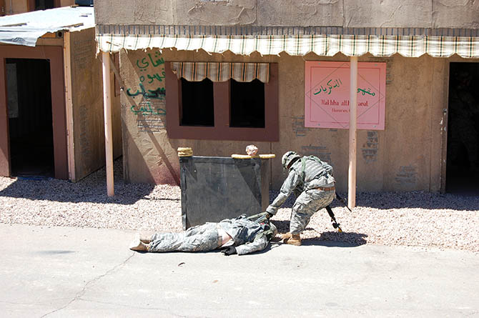
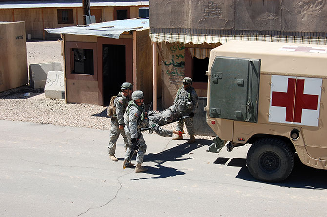
In other words, at the most basic level, soldiers will use Fort Irwin’s facsimile villages to practice clearing structures and navigating unmapped, roofed alleyways through cities without clear satellite communications links. However, at least in the training activities accessible to public visitors, the architecture is primarily a stage set for the theater of human relations: a backdrop for meeting and befriending locals (again, paid actors), controlling crowds (actors), rescuing casualties (Fort Irwin’s roster of eight amputees are its most highly paid actors, we learned, in recompense for being literally dragged around during simulated combat operations), and, ultimately, locating and eliminating the bad guys (the Blackhorse regiment).

[Image: Photo courtesy of Venue].

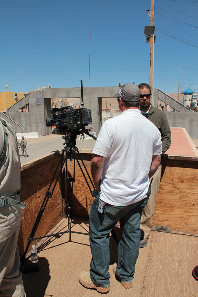
In the series of set-piece training exercises that take place within the village, the action is coordinated from above by a ring of walkie-talkie connected scenographers, including an extensive internal media presence, who film all of the simulations for later replay in combat analysis. The sense of being on an elaborate, extremely detailed film set is here made explicit. In fact, visitors are openly encouraged to participate in this mediation of the events: we were repeatedly urged to take as many photographs as possible and to share the resulting images on Facebook, Twitter, and more.
[Images: Photos courtesy of Venue].

Appropriately equipped with ear plugs and eye protection, we filed upstairs to a veranda overlooking one of the village’s main throughways, where we joined the “Observer Coaches” and film crew, taking our positions for the afternoon’s scripted exercise.

[Image: Photo courtesy of Venue].

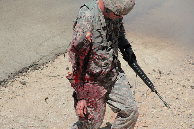
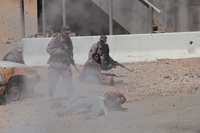
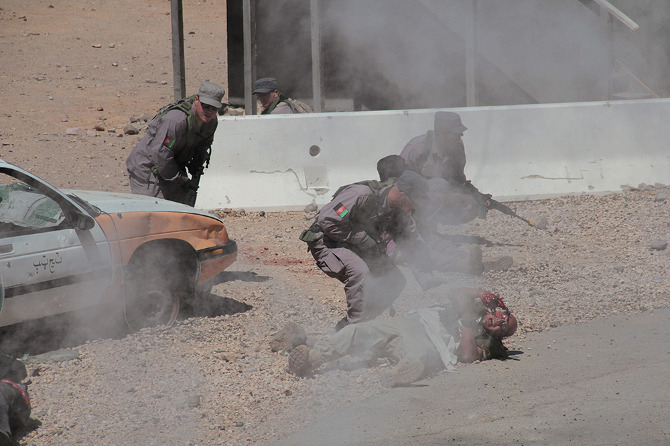
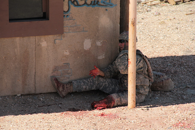
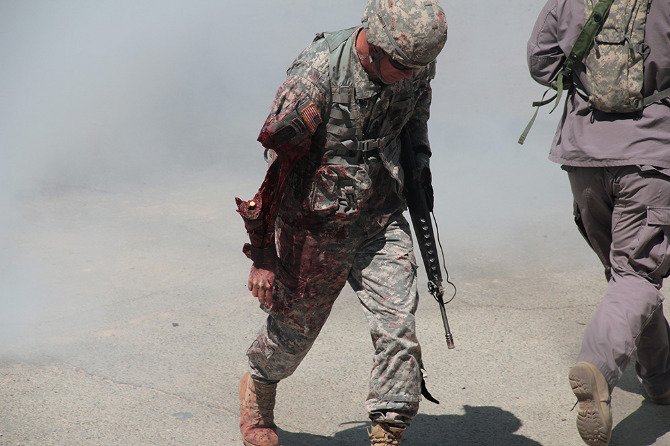
Loud explosions, smoke, and fairly grisly combat scenes ensued—and thus, despite their simulated nature, involving Hollywood-style prosthetics and fake blood, please be warned that many of the forthcoming photos could still be quite upsetting for some viewers.
[Images: Photos courtesy of Venue].

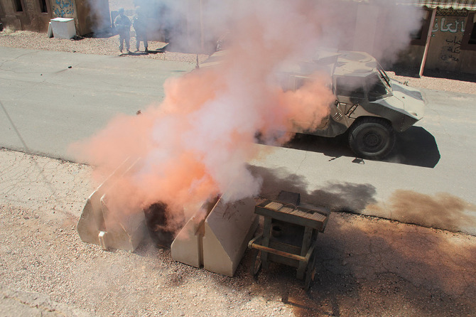
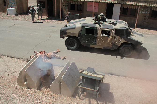
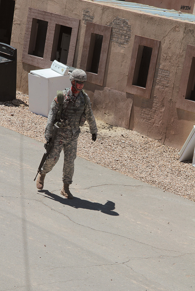
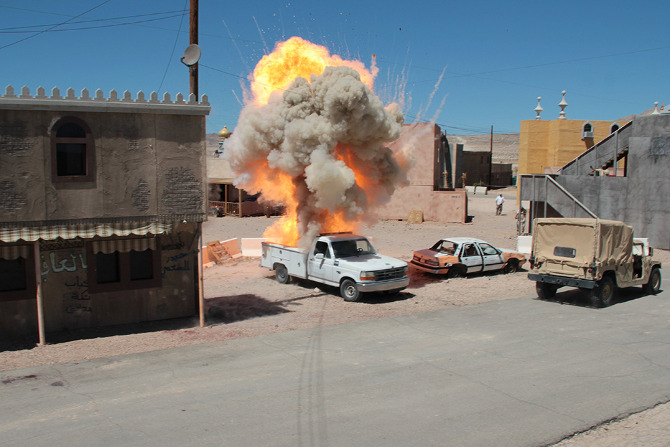
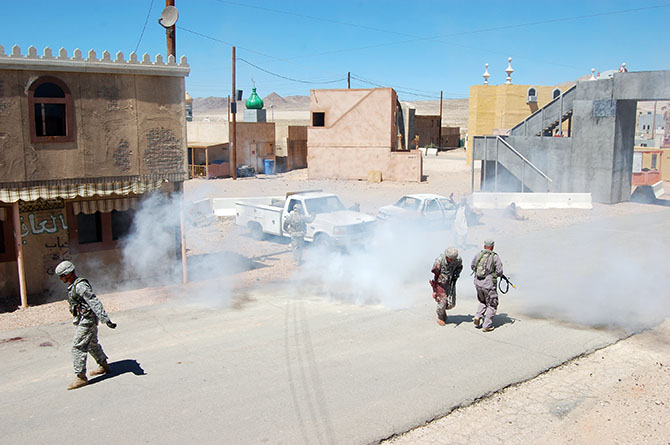
The afternoon’s action began quietly enough, with an American soldier on patrol waving off a man trying to sell him a melon. Suddenly, a truck bomb detonated, smoke filled the air, and an injured woman began to wail, while a soldier slumped against a wall, applying a tourniquet to his own severed arm.
[Images: Photos courtesy of Venue].

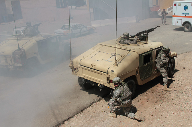
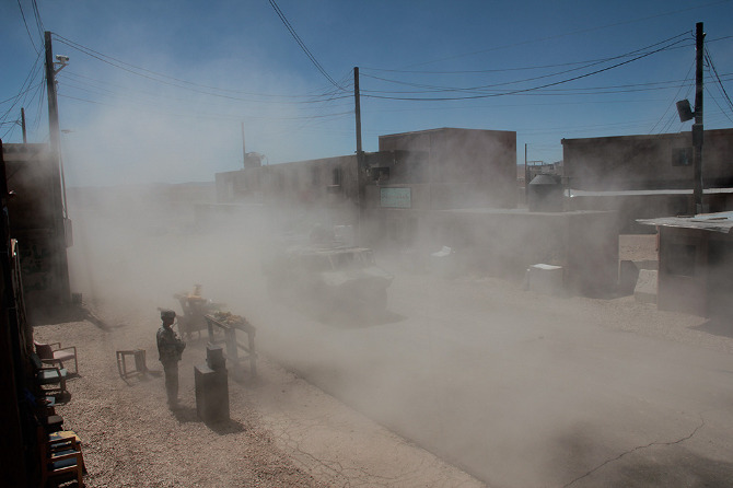
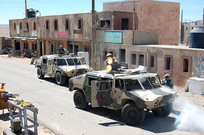
In the subsequent chaos, it was hard to tell who was doing what, and why: gun trucks began rolling down the streets, dodging a live goat and letting off round after round as insurgents fired RPGs (mounted on invisible fishing line that blended in with the electrical wires above our heads) from upstairs windows; blood-covered casualties were loaded into an ambulance while soldiers went door-to-door with their weapons drawn; and, in the episode’s climax, a suicide bomber blew himself up directly beneath us, showering our tour group with ashes.
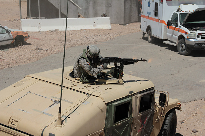
[Images: Photos courtesy of Venue].

Twenty minutes later, it was all over. The smoke died down; the actors reassembled, uninjured, to discuss what just occurred; and the sound of blank rounds being fired off behind the buildings at the end of the exercise echoed through the streets.

[Image: Photo courtesy of Venue].

Incredibly, blank rounds assigned to a particular exercise must be used during that exercise and cannot be saved for another day; if you are curious as to where your tax dollars might be going, picture paid actors shooting entire magazines full of blank rounds out of machine guns behind simulated Middle Eastern buildings in the Mojave desert. Every single blank must be accounted for, leading to the peculiar sight of a village’s worth of insurgents stooped, gathering used blank casings into their prop kettles, bread baskets, and plastic bags.
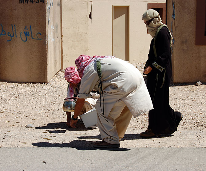
[Images: Photos courtesy of Venue].

Finally, we descended back down onto the street, dazed, ears ringing, and a little shocked by all the explosions and gunfire. Stepping carefully around pools of fake blood and chunks of plastic viscera, we made our way back to the lobby of the International Hotel for cups of water and a debrief with soldiers involved in planning and implementing the simulation.

[Image: Photo courtesy of Venue].

Our hosts there were an interesting mix of earnest young boys who looked like they had successful careers in politics ahead of them, standing beside older men, almost stereotypically hard-faced, who could probably scare an AK-47 into misfiring just by staring at it, and a few female soldiers.

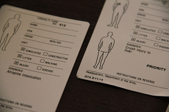
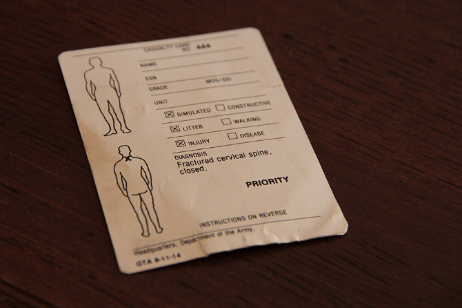
Somewhat subdued at this point, our group sat on sofas that had seen better days and passed around an extraordinary collection of injury cards handed out to fallen soldiers and civilians. These detail the specific rules given for role-playing a suite of symptoms and behavior—a kind of design fiction of military injury.

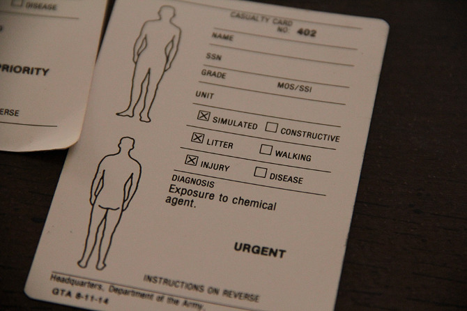
[Images: Photos courtesy of Venue].

A few of us tried on the MILES (Multiple Integrated Laser Engagement System) harnesses that soldiers wear to sense hits from fired blanks, and then an enemy soldier demonstrated an exploding door sill.
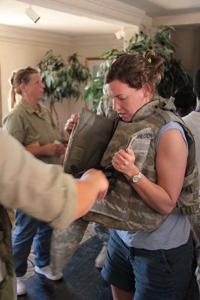
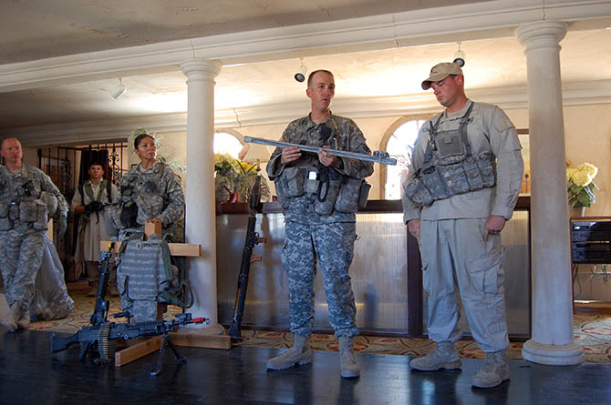
[Images: Photos courtesy of Venue].

While the film crew and Observer Coaches prepared for their “After Action Review,” our guides seemed talkative but unwilling to discuss how well or badly the afternoon’s session had gone. We asked, instead, about the future of Fort Irwin’s villages, as the U.S. withdraws from Afghanistan. The vision is to expand the range of urban conditions into what Ferrell termed a “Decisive Action Training Environment,” in which U.S. military will continue to encounter “the world’s worst actors” [sic]—”guerrillas, criminals, and insurgents”—amidst the furniture of city life.

As he escorted us back down the market street to our bus, one soldier off-handedly remarked that he’d heard the village might be redesigned soon as a Spanish-speaking environment—before hastily and somewhat nervously adding that he didn’t know for sure, and, anyway, it probably wasn’t true.

[Image: Photo courtesy of Venue].

The “town” is visible on Google Maps, if you’re curious, and it is easy to reach from Barstow. Tours of “The Box” are run twice a month and fill up quickly; learn more at the Fort Irwin website, including safety tips and age restrictions.

• • •

For more Venue content, exploring human interactions with the built, natural, and virtual environments through 16 months of travel around the continental United States, check out the Venue website in full.