Agency of the Subsurface

[Image: The Heathen Gate at Carnuntum, outside Vienna; photo by Geoff Manaugh.]

Last summer, a geophysicist at the University of Vienna named Immo Trinks proposed the creation of an EU-funded “International Subsurface Exploration Agency.” Modeled after NASA or the ESA, this new institute would spend its time, in his words, “looking downward instead of up.”

The group’s main goal would be archaeological: to map, and thus help preserve, sites of human settlement before they are lost to development, natural decay, climate change, and war.

Archaeologist Stefano Campana, at the University of Siena, has launched a comparable project called Sotto Siena, or “Under Siena”—abbreviated as SOS—intended to survey all accessible land in the city of Siena.

[Image: A few of Siena’s innumerable arches; photo by Geoff Manaugh.]

That project’s goal is primarily to catalog the region’s millennia of human habitation and cultural artifacts, but, like Immo Trinks and his proposed ISEA, is also serving to document modern-day infrastructure, such as pipes, utilities, sewers, and more. (When I met Campana in Siena last year, I was interested to learn that a man who had walked over to say hello, who was introduced to me as an enthusiastic supporter of Campana’s work, was actually Siena’s chief of police—it’s not just archaeologists who want to know what’s going on beneath the streets.)

I had the pleasure of tagging along with both Trinks and Campana last year as part of my Graham Foundation grant, “Invisible Cities,” and a brief write-up of that experience is now online over at WIRED.

The article begins in Siena, where I joined Campana and two technicians from the Livorno-based firm GeoStudi Astier for a multi-hour scan of parks, piazzas, and streets, using a ground-penetrating radar rig attached to a 4WD utility vehicle.

[Images: The GPR rig we rode in that day, owned and operated by GeoStudi Astier; photos by Geoff Manaugh.]

We stayed out well past midnight, at one point scanning a piazza in front of the world’s oldest bank, an experience that brought back positive memories from my days reporting A Burglar’s Guide to the City (alas, we didn’t discover a secret route into or out of the vault, but just some fountain drains).

In Vienna, meanwhile, Trinks drove me out to see an abandoned Roman frontier-city and military base called Carnuntum, near the banks of the Danube, where he walked me through apparently empty fields and meadows while narrating all the buildings and streets we were allegedly passing through—an invisible architecture mapped to extraordinary detail by a combination of ground-penetrating radar and magnetometry.

“We want to map it all—that’s the message,” Trinks explained to me. “You’re not just mapping a Roman villa. You’re not mapping an individual building. You are mapping an entire city. You are mapping an entire landscape—and beyond.”

An estimated 99% of Carnuntum remains unexcavated, which means that our knowledge of its urban layout is almost entirely mediated by electromagnetic technology. This, of course, presents all sorts of questions—about data, machine error, interpretation, and more—that were explained to me on a third leg of that trip, when I traveled to Croatia to meet Lawrence B. Conyers.

[Image: A gorge leading away behind the archaeological site I visited on the island of Brač, Croatia; photo by Geoff Manaugh.]

Conyers is an American ground-penetrating radar expert who, when we met, was spending a couple of weeks out on the island of Brač, near the city of Split. He had traveled there to scan a hilltop site, looking for the radar signatures of architectural remains, in support of a project sponsored by the University of Colorado at Boulder.

Conyers supplies a voice of caution in the WIRED piece, advising against over-relying on expensive machines for large-scale data collection if the people hoarding that data don’t necessarily know how to filter or interpret it.

[Image: Lawrence Conyers supervises two grad students using his ground-penetrating radar gear; photo by Geoff Manaugh.]

The goal of an International Subsurface Exploration Agency could rise or fall, in other words, not just on questions of funding or public support, but on the limits of software analysis and human interpretation: are we sure that what we see on the screens of our machines is actually there, underground?

When we spoke in Siena, Campana used the metaphor of a medical biopsy, insisting that archaeologists and geophysicists will always need to excavate, not just for the recovery of historical artifacts and materials, but for verifying their own hypotheses, literally testing the ground for things they think they’ve seen there.

Archaeologist Eileen Ernenwein, co-editor of the journal Archaeological Prospection, also emphasized this to me when I interviewed her for WIRED, adding a personal anecdote that has stuck with me. During her graduate thesis research, Ernenwein explained, she found magnetic evidence of severely eroded house walls at an indigenous site in New Mexico, but, after excavating to study them, realized that the structure was only visible in the electromagnetic data. It was no less physically real for only being visible magnetically—yet excavation alone would have almost certainly have missed the site altogether. She called it “the invisible house.”

In any case, many things have drawn me to this material, but the long-term electromagnetic traces of our built environment get very little discussion in architectural circles, and I would love this sort of legacy to be more prominently considered. What’s more, our cultural obsession with ruins will likely soon begin to absorb new sorts of images—such as radar blurs and magnetic signatures of invisible buildings—signaling an art historical shift in our representation of the architectural past.

For now, check out the WIRED article, if you get a chance.

(Thanks again to the Graham Foundation for Advanced Studies in the Fine Arts for supporting this research. Related: Through This Building Shines The Cosmos.)

Until Proven Safe

[Image: Dressed in 21st-century personal protective equipment (PPE), I am standing next to Dr. Luigi Bertinato, wearing period plague doctor gear from the time of the Black Death, inside the library of the Querini Stampalia, Venice. Photo by Nicola Twilley.]

Long-time readers of this blog will hardly be surprised to hear of my interest in quarantine, a topic I’ve been posting and lecturing about since at least 2009. The Landscapes of Quarantine exhibition at Storefront for Art and Architecture, curated with Nicola Twilley back in 2010, was the beginning of a much larger project that we eventually returned to, several years ago, for a book on the subject.

Originally titled—and sold to our editor as—The Coming Quarantine, we had to change the book’s name when COVID-19 hit. Surreally, we ended up finishing a book about quarantine while in a state of medical detention—indeed, at one point late last spring, more than half the world’s human population was in some state of quarantine or lockdown.

Our book’s hypothesis and prediction was, in fact, that we would all be quarantining more in the future, not less, relying on this seemingly medieval tool of spatial isolation to protect ourselves from emerging diseases for which we had no natural immunity, no available vaccination, and no cure. Why quarantine? It is the use of space and time to overcome uncertainty, creating a buffer between ourselves and a potentially infectious other until that suspected threat can be proven safe.

[Image: An arch inside the abandoned lazaretto, or quarantine hospital, on Manoel Island, Malta; photo by Geoff Manaugh.]

Until Proven Safe: The History and Future of Quarantine—the book we have been traveling for, reporting, and working on since summer 2016—finally comes out tomorrow, July 20th. I am unbelievably excited about this book, for millions of reasons. On one level, it combines so many of the long-running interests here on this blog, from quarantine itself to architectural ruins, mythology & horror, science fiction, space exploration, the Army Corps of Engineers, agricultural landscapes, strange animal diseases, extraordinary engineering controls, the ethical dangers of smart homes, even nuclear waste.

Having posted little to nothing about this book over the past few years—indeed, having posted almost nothing about COVID-19—it’s also immensely relieving to finally release this thing into the world.

[Image: Inside the lazaretto at Ancona, Italy; photo by Geoff Manaugh.]

Some highlights that I think would appeal to BLDGBLOG readers include Nicky’s and my travelogue around the Adriatic and Mediterranean seas, exploring ruined lazarettos in the footsteps of 18th-century British prison reformer—and quarantine critic—John Howard. We climbed locked fences into ruins on Malta, took a night ship across the Adriatic to disembark near the extraordinary pentagonal lazaretto in Ancona, and we got to tour the then-closed Lazzaretto Nuovo in Venice, Italy, with the local man intent on preserving it. (His original plan, he admitted, was to turn the island into a martial arts dojo.)

In other parts of the book, we sit down with the head of the Disinfected Mail Study Circle, based in North London. That group collects rare pieces of mail sent to and from sites of quarantine; like characters in a Thomas Pynchon novel, their postal archaeology has revealed previously forgotten outbreaks and odd geopolitical details about the formation of international borders.

We also visited the first federal quarantine facility, then under construction, in the United States in more than a hundred years, mere months before COVID-19, and we spoke with the former head of the Army Corps of Engineers about plans for retrofitting hotels, convention centers, and stadiums, as well as the prospect of pop-up home quarantine kits in the near-future. We visited the Ebola high-level isolation unit at the Royal Free Hospital in London—where Nicky climbed inside.

[Image: Nicola Twilley inside the high-level isolation unit’s Trexler Ebola system; photo by Geoff Manaugh.]

In the latter half of the book—primarily dedicated to nonhuman quarantine, or quarantine applied to the plant, animal, and mineral kingdoms, capped off by a look at “planetary protection” and the risk of alien microbes—we were able to see a brand-new high-level animal-disease research lab in the middle of U.S. cattle country. This is the nation’s replacement for the aging facility on Plum Island, subject of countless conspiracy theories.

Elsewhere, we went deep into WIPP—the Waste Isolation Pilot Plant—outside Carlsbad, New Mexico, to see nuclear waste being buried and isolated from the Earth’s biosphere for a federally-mandated time periods of at least 100,000 years. We got to see the Apollo moon rocks and learn about the history of lunar quarantine, and even sat down with two of NASA’s Planetary Protection Officers—and their counterpart at the European Space Agency—to discuss the quarantine challenge of bringing Mars geology back to Earth. Along the way, we got to see Perseverance, the Mars rover, before its long (and successful) journey to Mars.

[Image: Walking inside the Waste Isolation Pilot Plant, a salt mine 2,150 feet below the surface of the Earth, where the United States is permanently burying nuclear waste; photo by Nicola Twilley.]

Reporting the book also led us to a series of high-level pandemic simulations over the course of several years—all the way up to the incredible experience of sitting in on a simulation in October 2019, the premise of which was a global outbreak of a novel coronavirus. As we sat there, listening to government figures role-play what they would do, the very earliest cases of COVID-19 were likely circulating in China, undetected.

We also look at the limits of mathematical modeling, the encroachment of algorithms and Big Data into the future of quarantine, and the dystopian potential of involuntary medical isolation automatically enforced by today’s smart homes.

And, through all of that, one of our biggest coups, I think, was recording hours of interviews with the head of the CDC’s division of global migration and quarantine, visiting him in his office at the CDC and recording anguished, on-the-record discussions during the Trump Administration about the nation’s COVID-19 response.

A great way to get a flavor of the book would be to check out excerpts published in WIRED and The Guardian—and, tomorrow morning, The Atlantic—or to listen to the Gastropod episode we did on quarantine, agriculture, and threats to the world’s chocolate supply.

[Image: Until Proven Safe, with a cover design by Alex Merto.]

If you’re tempted, you can order a copy from Bookshop, Indiebound, Amazon, Barnes & Noble, or your local independent bookshop, etc. etc.

Note: This post contains affiliate links to Amazon and Bookshop from which I might draw a small percentage of any book sales.

Snare Space

[Image: EO Browser, Sinergise Ltd/Attribution 4.0 International CC by 4.0), via The War Zone.]

Comas of temporarily abandoned cruise ships—maritime ruins in an age of COVID-19—have been popping up on the outer edges of Caribbean islands, visible in satellite photos of the sea.

Ships from Carnival, Celebrity, and Royal Caribbean now form a strange new archipelago, a network of ships “spread out loosely in three groups spanning some 30 miles” west from the Bahamas, The War Zone explains.

“Although there are no passengers aboard these ships,” we read, “some of which cost well over a billion dollars to build, there are plenty of people still on board. Much of their crews are literally trapped on these vessels. As the world cut back travel due to COVID-19’s explosive spread around the globe and cruise ships became very unwanted guests at long-established ports of call, cruise line workers were trapped at their floating workplaces far from home.”

The War Zone has more detail, although you can also check out CNN or even this vaguely related, earlier link at The New York Times.

But what strikes me here is how the failure of a particular business model has had near-immediate spatial effects, verging on apocalyptic surreality: an overnight surplus of ships and their workers, with nowhere to go, are, for the indeterminate future, a kind of stateless micro-polity, inconveniently flagged to countries unwilling to offer support and unable to dock or disembark in intermediate nation-states for fear they might spread COVID-19.

In fact, as that New York Times link, above, points out, “An estimated 150,000 crew members with expired work contracts have been forced into continued labor aboard commercial ships worldwide to meet the demands of governments that have closed their borders and yet still want fuel, food and supplies.” 150,000! “The result has been a string of desperate emails, text messages and calls to shore. Pleas to governments have gone unanswered.”

For some reason, I’m reminded of the apocryphal story of Babu Sassi, a man from Kerala who allegedly operated a construction crane atop what would soon become the tallest building in the world, now known as the Burj Khalifa. Sassi, the story goes, found the daily journey down from his perch to the surface of the Earth—and back again the next day—so personally tedious and so economically inconvenient that, one day, he simply refused, instead staying in place in his crane and living up there for more than a year (if urban legends are to be believed).

He slept, ate, and worked at such a remove from the rest of the world that his fellow humans became nothing more than dots, blips moving here and there on the horizon, like people stranded on distant ships. Sassi’s decision, of course, unlike these crews stuck on structures marooned at sea, had the illusion of agency; his exile from the earth’s surface seemed not obligatory but self-divined.

Extreme economic circumstances produce equally extreme spatial scenarios. Whether it’s someone living alone atop the world’s tallest construction crane, whole families moving into corporate mining towns in the Canadian Arctic, or these still-crewed ships on pause at sea, spatial loopholes open and people slip into them, sometimes fatally absorbed into the circumstances of their labor.

The Atlas of Natural Regions

[Image: “Saint-Valentin, Champagne berrichonne (Centre-Val-de-Loire), 2019, by Eric Tabuchi].

I’ve been enjoying the Instagram account of photographer Eric Tabuchi for quite a while now. Tabuchi is working on an ambitious ten-year photographic project, kicked off in 2017, that he calls The Atlas of Natural Regions, basically a catalog of spatial conditions found throughout France.

The project “aims to create a photographic archive offering a broad overview of the diversity of the buildings, but also the landscapes, that make up the French territory,” Tabuchi explains. “Ultimately, 50 shots will be taken in each of France’s natural regions, geographical and cultural entities that are simple to grasp by their size (a few tens of kilometers).”

It will include 25,000 photographs when it’s done—and I am already excited to see the final exhibition or book when it’s complete. So far, there have been flooded quarries, sports complexes, and emergency training towers, industrial ruins, coastal bunkers, and surreal scenes that resemble something designed by Simon Stålenhag.

Tabuchi’s Instagram account is well worth following, and you can also support his work by purchasing a print.

From Bullets, Seeds

[Image: From the “Flower Shell” project by Studio Total].

The Department of Defense is looking to develop “biodegradable training ammunition loaded with specialized seeds to grow environmentally beneficial plants that eliminate ammunition debris and contaminants.”

As the DoD phrases it, in a new call-for-proposals, although “current training rounds require hundreds of years or more to biodegrade,” they are simply “left on the ground surface or several feet underground at the proving ground or tactical range” after use.

Worse, “some of these rounds might have the potential [to] corrode and pollute the soil and nearby water.”

The solution? From bullets to seeds. Turn those spent munitions into gardens-to-come:

The US Army Corps of Engineers’ Cold Regions Research and Engineering Laboratory (CRREL) has demonstrated bioengineered seeds that can be embedded into the biodegradable composites and that will not germinate until they have been in the ground for several months. This SBIR effort will make use of seeds to grow environmentally friendly plants that remove soil contaminants and consume the biodegradable components developed under this project. Animals should be able to consume the plants without any ill effects.

The potential for invasive species to take root and dominate the fragile, disrupted ecology of a proving ground is quite obvious—unless region-specific munitions are developed, with bullets carefully chosen to fit their ecological context, a scenario I find unlikely—but this is nonetheless a surprising, almost Land Art-like vision for the U.S. military.

Recall our earlier look at speculative mass-reforestation programs using tree bombs dropped from airplanes. This was a technique that “could plant as many as a million trees in one day,” in a state of all-out forest warfare. Here, however, a leisurely day out spent shooting targets in a field somewhere could have similar long-term landscape effects: haphazardly planted forests and gardens will emerge in the scarred grounds where weapons were once fired and tested.

In fact, the resulting plants themselves could no doubt also be weaponized, chosen for their tactical properties. Consider buddleia: “buddleia grows fast and its many seeds are easily dispersed by the wind,” Laura Spinney wrote for New Scientist back in 1996. “It has powerful roots used to thin soil on rocky substrata, ideally suited to penetrating the bricks and mortar of modern buildings. In London and other urban centres it can be seen growing out of walls and eves.”

It is also, however, slowly and relentlessly breaking apart the buildings it grows on.

Pack buddleia into your bullets, in other words, and even your spent casings will grow into city-devouring thickets, crumbling your enemy’s ruins with their roots. Think of it as a botanical variation on the apocryphal salting of Carthage.

In any case, if seed-bullets sound like something you or your company can develop, you have until February 7, 2017 to apply.

(Spotted via Adam E. Anderson).

Amidst the Ruins of Military Replicas

[Image: The Atlantic Wall at Hankley Common, Surrey, UK; Instagram by BLDGBLOG].

After blogging two years ago about the ruins of a simulated fragment of the WWII Atlantic Wall—the notorious Nazi coastal defensive system—now slowly crumbling in the woods of Surrey, I finally had an opportunity to go hike it in person with my wife and in-laws.

[Image: The Atlantic Wall at Hankley Common, Surrey, UK; Instagram by BLDGBLOG].

The ruins themselves are both larger than you’d expect and quite compact, forming a ridge of lichen-covered concrete, jagged with rebar, nearly hidden in the vegetation.

A Dutch family was also there climbing over the ruins, and as we headed slightly further up the hillside into the trees smaller test-obstacles emerged, including “dragon’s teeth” and monolithic cuboids of stained concrete.

[Image: The Atlantic Wall at Hankley Common, Surrey, UK; Instagram by BLDGBLOG].

We arrived during a live Ministry of Defence training exercise, with soldiers wandering out across the terrain, speaking to one another on radio headsets, their movements interrupted here and there by Sunday hikers out for an afternoon stroll.

[Image: A soldier at Hankley Common, Surrey, UK; Instagram by BLDGBLOG].

This led to the surreal scene of seeing fully outfitted military figures crouched down behind shrubbery, holding machine guns, while kids, their dogs, and their grandparents noisily ambled by. It felt like some sort of stage play gone wrong.

[Image: Hiking at Hankley Common, Surrey, UK; Instagram by BLDGBLOG].

Then the soldiers disappeared again over the next ridge and we were left looking out over an empty landscape of heather and gorse, the ruins now behind us somewhere in the thicket waiting for next weekend’s hikers to come by.

Saltair

saltair_web[Image: Saltair, photographed ca. 1901, courtesy of the Library of Congress].

While writing the previous post, I was reminded of the old sprawling Venetian structure called “Saltair,” built on the Great Salt Lake atop roughly 2,000 stilts, the ruins of which remain visible.

posts[Image: Via Google Maps].

Although the original building, seen in the topmost image, burned down in 1925, it was replaced by another behemoth architectural complex that later appeared in the film Carnival of Souls.

But it’s the sheer nature of piers—those bridges to nowhere, promising endless extensions of dry land over even the most abyssal of drowned landscapes—that captures my interest here, with Saltair promising something like an American Oil Rocks, that labyrinth of platforms and elevated roadways that snakes out, and out, and out, into the Caspian Sea, only, in this case, styled like some Renaissance palace of cupolas and domes, with rumors that it’s so vast, its furthest rooms have yet to be visited.

Burial Grounds

Blogger Andrew Ray of Some Landscapes recently re-read The Wind in the Willows to his son, stumbling on “an intriguing passage that I’d forgotten all about, concerning Badger’s large underground home.” It is a scene where “the idea of the city has been literally buried,” where, “civilisations decline but nature endures,” an underground world of ruined architecture and vaulted halls disguised as forests.

Bunker Simulations

[Image: A replica of the Nazis’ Atlantic Wall defenses in Scotland; photo via Stirling 2014].

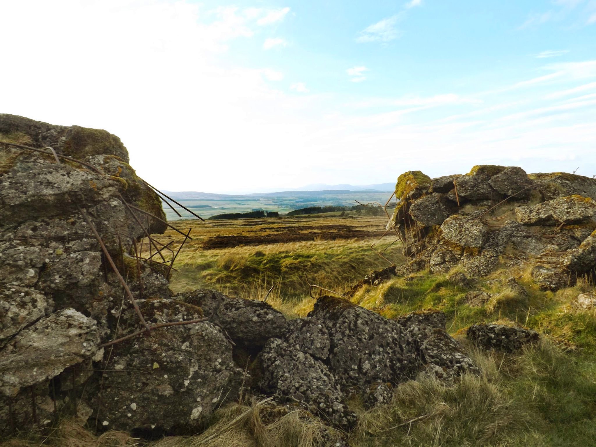
The continent-spanning line of concrete bunkers built by the Nazis during WWII, known as the “Atlantic Wall,” was partially recreated in the United Kingdom—in more than one location—to assist with military training.

These simulated Nazi bunkers now survive as largely overlooked ruins amidst the fields, disquieting yet picturesque earth forms covered in plants and lichen, their internal rebar exposed to the weather and twisted by explosives, serving as quiet reminders of the European battlefield.

The various wall sites even include trenches, anti-tank ditches, and other defensive works carved into the ground, forming a kind of landscape garden of simulated fortification.

[Image: A replica of the Atlantic Wall in Scotland; photo via Stirling 2014].
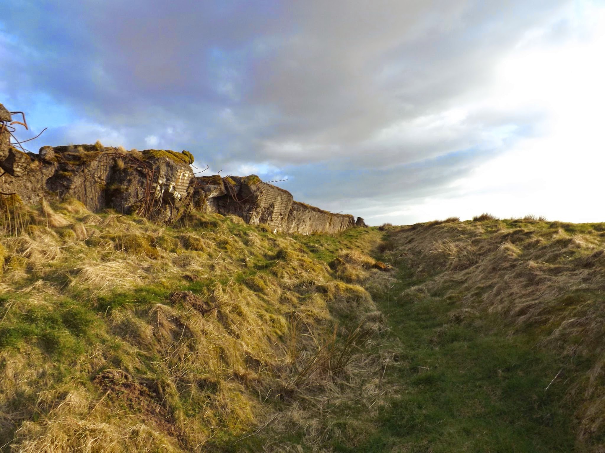
As the Herald Scotland reported the other day, one of these walls “was built at Sheriffmuir, in the hills above Dunblane, in 1943 as preparations were being made to invade Europe. The problem was the Nazis had built a formidable line of concrete defenses from Norway all the way to the Spanish border and if D-Day was to have any chance of success, the British and their allies would have to get over those defenses.”

This, of course, “is why the wall at Sheriffmuir was built: it was a way for the British forces to practise their plan of attack and understand what they would face. They shot at it, they smashed into it, and they blew it up as a way of testing the German defences ahead of D-Day.”

[Image: A replica of the Atlantic Wall in Scotland; photo via Stirling 2014].

It would certainly be difficult to guess what these structures are at first glance, or why such behemoth constructions would have been built in these locations; stumbling upon them with no knowledge of their history would suggest some dark alternative history of WWII in which the Nazis had managed to at least partially conquer Britain, leaving behind these half-buried fortresses in their wake.

Indeed, the history of the walls remains relatively under-exposed, even in Britain, and a new archaeological effort to scan all of the defenses and mount an exhibition about them in the Dunblane Museum is thus now underway.

[Image: A replica of the Atlantic Wall in Scotland; photo via Stirling 2014].

The story of the Scottish wall’s construction is also intriguingly odd. It revolves around an act of artistic espionage, courtesy of “a French painter and decorator called Rene Duchez.”

Duchez, the newspaper explains, “got his hands on the blueprints for the German defences while painting the offices of engineering group TODT, which [had been hired] to build the Atlantic walls. He hid the plans in a biscuit tin, which was smuggled to Britain and used as the blueprint for the wall at Sheriffmuir.”

But Scotland is not the only UK site of a simulated Nazi super-wall: there were also ersatz bunkers built in Surrey, Wales, and Suffolk. In fact, the one in Surrey, built on Hankley Common, is not all that far from my in-laws, so I’ll try to check it out in person next time I’m over in England.

[Images: An Atlantic Wall replica in Surrey; top photo by Shazz, bottom three photos via Wikipedia].

Attempts at archaeological preservation aside, these walls seem destined to fade into the landscape for the next several millennia, absorbed back into the forests and fields; along the way, they’ll join other ancient features like Hadrian’s Wall on the itinerary of future military history buffs, just another site to visit on a slow Sunday stroll, their original context all but forgotten.

(Spotted via Archaeology. Previously on BLDGBLOG: In the Box: A Tour Through The Simulated Battlefields of the U.S. National Training Center and Model Landscape].