Saddam’s Palaces: An Interview with Richard Mosse

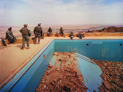
[Image: Ruined swimming pool at Uday’s Palace, Jebel Makhoul, Iraq (2009); photo by Richard Mosse].

Photographer Richard Mosse first appeared on BLDGBLOG last year with his unforgettable visual tour through the air disaster simulations of the international transportation industry.

He and I have since kept in touch—so, when Mosse returned from a trip to Iraq this spring, he emailed again with an unexpectedly intense new body of work. These extraordinary images—published here for the first time—show the imperial palaces of Saddam Hussein converted into temporary housing for the U.S military.

Vast, self-indulgent halls of columned marble and extravagant chandeliers, surrounded by pools, walls, moats, and, beyond that, empty desert, suddenly look more like college dormitories. Weight sets, flags, partition walls, sofas, basketball hoops, and even posters of bikini’d women have been imported to fill Saddam’s spatial residuum. The effect is oddly decorative, as if someone has simply moved in for a long weekend, unpacking an assortment of mundane possessions.

The effect is like an ironic form of camouflage, making the perilously foreign seem all the more familiar and habitable—a kind of military twist on postmodern interior design.

Of course, then you notice, in the corner of the image, a stray pair of combat boots or an abandoned barbecue or a machine gun leaned up against a marble wall partially shattered by recent bomb damage—amidst the dust of collapsed ceilings and ruined tiles—and this architecture, and the people who now go to sleep there every night, suddenly takes on a whole new, tragic narrative.

Fascinated by the dozens and dozens of incredible photos Mosse emailed—only a fraction of which appear here—I asked him to describe the experience of being a photographer in Iraq.
The ensuing dialogue appears below.


• • •

BLDGBLOG: What was the basic story behind your visit to Iraq? Was it self-funded or sponsored by a gallery?

Richard Mosse: The trip was backed by a Leonore Annenberg Fellowship in the Performing and Visual Arts, which I received after graduating from Yale last summer with an MFA in photography. The Fellowship provides enough to fund two full years of traveling to make new photographs, and I applied to shoot in a range of places, including Iraq. My proposal was to make work around the idea of the accidental monument. I’m interested in the idea that history is something in a constant state of being written and rewritten—and the way that we write history is often plain to see in how we affect the world around us, in the inscriptions we make on our landscape, and in what stays and what goes.

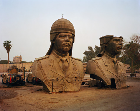
[Image: Saddam’s heads, taken from the roof of the Republican Guard Palace, now located at Al-Salam Palace, Forward Operating Base Prosperity, Baghdad, Iraq (2009); photo by Richard Mosse].

I suppose it’s an idea that captured me while traveling through Kosovo in 2004. I saw a building by the side of the road there that lay mined and shattered in a field of flowers. It was almost entirely collapsed—except for a church cupola which lay at a pendulous angle, though otherwise perfectly intact on a pile of rubble. It was a marvelously pictorial vision of the Kosovo Albanian desire to rewrite the history books. In other words, what I saw before me was not an act of mere vandalism, but a decisive act by the Kosovo Albanian community to disavow the fact of Serb Orthodox church heritage in the region. The removal of religious architecture is a terrible crime, and it constitutes an act of ethnic cleansing (remember Kristallnacht); yet I couldn’t help but interpret this as an attempt to create a brave new Kosovo Albanian world.

I began to see architecture as something that can reveal the ways in which we alter the past in order to construct a new future, as a site in which past, present, and future come together to be reformed. And it’s not the only one: language—our words and the way we use them—are another fine barometer of these things.

But architecture is something I felt I could research and portray using the dumb eye of my camera.

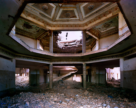
[Image: JDAM bomb damage within Saddam’s Palace interior, Jebel Makhoul, Iraq (2009); photo by Richard Mosse].

BLDGBLOG: Beyond the most obvious reasons—for instance, there’s a war going on—why did you go to Iraq? Was there something in particular that you were hoping to see? 

Mosse: I had heard plenty about Saddam’s palaces. They were the focus of the International Atomic Energy Association’s tedious investigations in the years preceding the invasion, and the news was always full of delegations being turned away from this or that palace. Why were we so keen to get inside Saddam’s palaces? Because he built so many—81 in total. Surely, we thought, he must be hiding something in those palace complexes. Surely he must be building subterranean particle accelerators. And, in the end, our curiosity got the better of us.

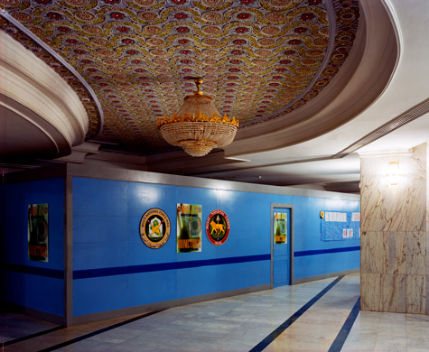
[Image: U.S.-built partition and air-conditioning units within Al-Salam Palace, Forward Operating Base Prosperity, Baghdad, Iraq (2009); photo by Richard Mosse].

In fact, Saddam was building palaces in every city as an expression of his authority. Palace architecture in Iraq served as a constant reminder of Saddam’s immanence. A palace in your city simply fed the sense that Saddam was not just nearby—he was everywhere. Saddam was omnipresent.

I once heard a Westerner tell me that, prior to the invasion, Iraqis driving near one of Saddam’s palaces would actually avert their eyes—they would refuse to look toward the palace. It was almost as if they were prisoners in a great outdoor version of Jeremy Bentham’s Panopticon. Curiously, the sentry towers along the perimeter walls of Al-Salam Palace in Baghdad face only outward; they’re screened from looking inward at the palace itself. People say it’s so the guards could not witness Saddam’s eldest son Uday’s relations with underage girls, but I rather like to think that it created a sense of the unseen authoritarian staring blankly outwards. It was like those ominous black turrets that the British army constructed over the hills of Belfast, packed with listening devices and telescopic cameras.

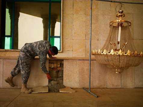
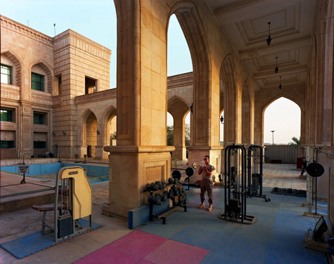
[Image: Outdoor gym, Al-Faw Palace, Camp Victory, Baghdad, Iraq (2009); photo by Richard Mosse].

But the idea of Iraqis averting their eyes from Saddam’s palace architecture also reminds me of something from W.G. Sebald’s book On the Natural History of Destruction.

BLDGBLOG: That’s an incredible book – I still can’t forget his descriptions of tornadoes of fire whirling through bombed cities and melting asphalt.

Mosse: Sebald recounts how the German population, after the end of WWII, would ride the trains, staring into their laps or at the ceiling—anywhere but out the window at the terrible wreckage of their cities. It was as if they were somehow disavowing the war by willing it away, by refusing to perceive it.

It’s interesting, then, that, in both instances—in both Iraq and in post-war Germany—it’s the tourist, or the outsider, who observes this blindness. I suppose that’s why I like to make photographs in foreign places: only the tourist notices the really dumb things that everyone else takes for granted.

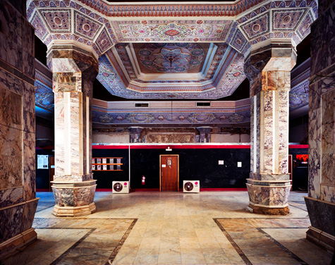
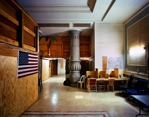
[Image: U.S. military telephone kiosks built within Birthday Palace interior, Tikrit, Iraq (2009); photo by Richard Mosse].

BLDGBLOG: The way these structures have been colonized is often amusing and sometimes shocking—the telephones, desks, and instant dormitories that turn an imperial palace into what looks like a suburban office or hospital waiting room. Can you describe some of the spatial details of these soldiers’ lives that most struck you? 

Mosse: It was extraordinary how some of the palace interiors had been transformed to accommodate the soldiers. Troops scurried beneath vaulted ceilings and glittering faux-crystal chandeliers. Lofty marble columns towered over rat runs between hastily constructed chipboard cubicles. Obama’s face beamed out of televisions overlooking the freezers and microwaves of provisional canteen spaces.

Many of the palaces have already been handed back to the Iraqis—but where Americans troops do remain, they live in very cramped conditions, pissing into a hole in the ground and waiting days just to shower. Life is hard on the front line, and it seems more than a little surreal to be ticking off the days in a dictator’s pleasure dome.

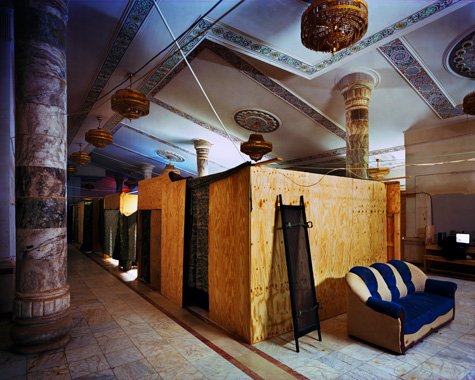
[Images: American dormitories built within Saddam’s Birthday Palace, Tikrit, Iraq (2009); photos by Richard Mosse].

The most interesting thing about the whole endeavor for me was the very fact that the U.S. had chosen to occupy Saddam’s palaces in the first place. If you’re trying to convince a population that you have liberated them from a terrible dictator, why would you then sit in his throne? A savvier place to station the garrison would have been a place free from associations with Saddam, and the terror and injustices that the occupying forces were convinced they’d done away with. Instead, they made the mistake of repeating history.

This is why I’ve titled this body of work Breach. “Breach” is a military maneuver in which the walls of a fortification (or palace) are broken through. But breach also carries the sense of replacement—as in, stepping into the breach. The U.S. stepped into the breach that it had created, replacing the very thing that it sought to destroy.

There are other kinds of breach—such as a breach of faith, a breach of confidence, or the breach of a whale rising above water for air. All of these senses were important to me while working on these photographs.

[Image: Provisional office wall partitions within Al-Faw Palace, Camp Victory, Baghdad, Iraq (2009); photo by Richard Mosse].

BLDGBLOG: In several of these photos, the soldiers are literally lifting tiles up from the floor as if the buildings had been left unfinished, or they’re peering through cracks in the palace walls. From what you could see, were Saddam’s palaces badly constructed or were they just heavily damaged during the war?

Mosse: Tiles simply fell from Al-Faw Palace because the cement used there had been poorly salinated. If that can happen to tiles, think what’s happening when the entire palace has been built on similarly salinated foundations! It’s just a matter of time before Al-Faw collapses in on itself.

You can already see arches cracking and walls beginning to sag.

[Image: Fallen tiles and chandeliers, Al Faw Palace, Camp Victory, Baghdad, Iraq (2009); photo by Richard Mosse].

But I’m reluctant to include images of U.S. soldiers pointing out problems with Saddam’s architecture, because it’s fairly evident that those could be a form of propaganda—and it’s easy to forget that many of these palaces were built during times of terrible sanctions imposed by the West. It might not seem very clear why Saddam was busy building palaces in a time of sanctions, but remember how the WPA was set-up during the Great Depression? I don’t want to risk being called an apologist for Saddam, but there are many ways to read a story.

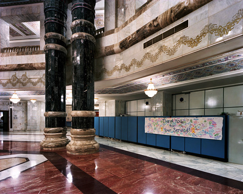
[Image: “Thank you for your service” banner, Al-Faw Palace interior, Camp Victory, Iraq (2009); photo by Richard Mosse].

That said, the palace is a fabulous monument to rushed construction, poor materials, and gaudy pomp. Saddam had apparently insisted that the palace be finished within two years, so many shortcuts were taken during construction. For example, the stairway banisters were made of crystallized gypsum—rather than carved marble—and where pieces didn’t quite fit together, they were just sanded down rather than replaced. Marble that was used in the palace (such as in the great spacious bathrooms) was imported from Italy, in spite of the trade embargo. And the plaster cast frescoes in the ceilings were imported from Morocco.

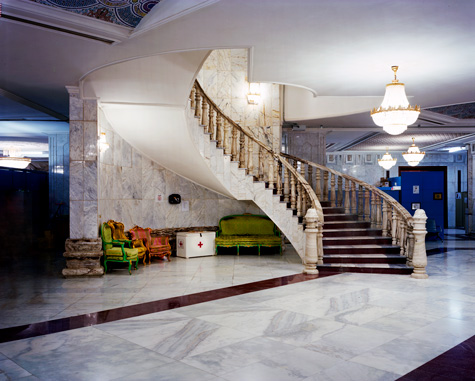
[Image: Stairway, Al-Faw Palace, Camp Victory, Baghdad, Iraq (2009); photo by Richard Mosse].

Al-Faw Palace later became the U.S, Army’s Command HQ, located at the heart of Camp Victory, near Baghdad International Airport. The palace is now teeming with generals, including General Odierno, the commander of coalition forces in Iraq. It’s a great, tiered wedding-cake structure, built around an inner hall with possibly the biggest and ugliest chandelier ever made. In fact, the chandelier is not made of crystal, but from a lattice of glass and plastic.

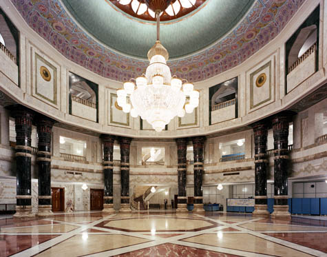
[Image: Chandelier, Al-Faw Palace, Camp Victory, Baghdad, Iraq (2009); photo by Richard Mosse].

The palace itself is then surrounded by a lake, which seems a bit like a moat—and it would be tempting to take a swim there, but the moat has been turned into a standing pool for Camp Victory’s sewage. In the summer, the place must be rather unpleasant: rank in all senses of the word, both military and sanitary. These artificial lakes surrounding the palace are also populated by the infamous “Saddam Bass.” It’s said that Saddam would feed the bodies of his political opponents to these monsters. In fact, they’re not bass at all, but a breed of asp fish. U.S. troops stationed at Camp Victory love to fish on these lakes, and a 105-pound specimen was recently caught.

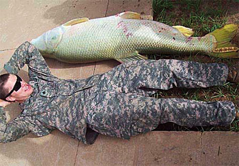
[Image: Tigris Salmon caught at Camp Victory Base, measuring 5 feet 10.5 inches and weighing 105 lbs. Image courtesy of the U.S. Army].

BLDGBLOG: How was your own presence received by those soldiers? Did you present yourself as a photojournalist or as an art photographer?

Mosse: The difference between art and journalism is, for me, of paramount importance—but twenty minutes in Iraq, and the dialectic recedes. I got a vague sense that Americans working there feel a little forgotten—unappreciated by people at home—so they’re very grateful for a camera, any camera, coming through. Even a big 8″x10″ bellows camera with an Irishman in a cape. There were a lot of rather obvious photographs that I chose not to make, and occasionally someone got offended by this.

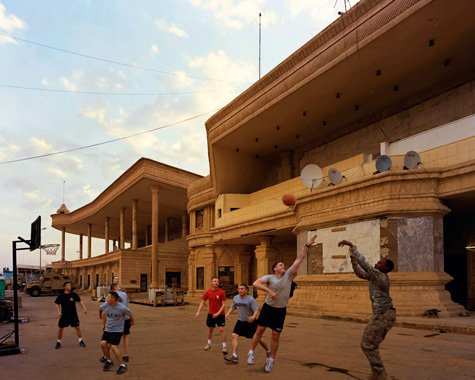
[Image: A game of basketball, Birthday Palace, Tikrit, Iraq (2009); photo by Richard Mosse].

BLDGBLOG: What was the soldiers’ opinion of these buildings? Did they ever just wander around and explore them, for instance, or was that a safety violation?

Mosse: I got the feeling that soldiers who occupied one of Saddam’s palaces were pretty interested in its original function. They seemed a lot more together, and happier with their job, compared with the troops I met on the massive, sprawling, purpose-built military bases in the Iraqi desert. Constant reminders of hierarchy and protocol were everywhere on the bigger bases—but on the more cramped and less comfortable palace bases, soldiers of different ranks seemed much closer and more capable of shooting the shit with each other, to borrow an American turn of phrase.

Though a far tougher environment, there seemed to be real job satisfaction—a sense that they were taking part in a piece of history.

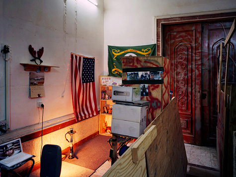
[Image: Detail of U.S. soldier’s living quarters, Birthday Palace interior, Tikrit, Iraq (2009); photo by Richard Mosse].

BLDGBLOG: Architect Jeffrey Inaba once joked, in an interview with BLDGBLOG, that Saddam’s palaces look a bit like McMansions in the suburbs of New Jersey. He quipped that “the architecture of state power and the architecture of first world residences don’t seem that far apart. Saddam’s palaces, while they’re really supposed to be about state power, look not so different from houses in New Jersey.” They’re not intimidating, in other words; they’re just tacky. They’re kitsch. Now that you’ve actually been inside these palaces, though, what do you think of that comparison? 

Mosse: Well, I’ve never been inside a New Jersey McMansion, so I can’t pass judgment. However, “McMansion” is a term borrowed by us in Ireland, where I’m from. Ireland was hard-hit by English penal laws, from the 17th century onward. One of those laws was the Window Tax. This cruel levy was imposed as a kind of luxury tax, to take money from anyone who had it; the result was that Irish vernacular architecture became windowless. The Irish made good mileage on the half-door, for instance, a kind of door that can be closed halfway down to keep the cattle out but still let the light in.

Aside from this innovation, and from subtleties in the method of thatching, Irish architecture never fully recovered—to the point that, even today, almost everyone in my country chooses their house from a book called Plan-a-Home, which you can buy for 15 euros. And if you have extra cash to throw in, you can flick to the back of the book and choose one of the more spectacular McMansions. Those are truly Saddam-esque.

[Image: Birthday Palace, Tikrit, Iraq (2009); photo by Richard Mosse].

BLDGBLOG: Finally, the “Green Zone,” as well as many of these palaces, are notoriously insular, cut-off behind security walls from the rest of Iraq. Did you actually feel like you were in Iraq at all—or in some strange architectural world, of walls and dormitories, surrounded by homesick Americans? 

Mosse: Not all of Saddam’s palaces are as isolated from reality as those situated in the green zone (or international zone, as it’s now called). One I visited near Tikrit—Saddam’s Birthday Palace—was even right at the heart of the city. Saddam was said to visit the palace each year on his birthday.

Wherever you go on the base, you’re eminently shootable—a fantastic sniper target—and can hear the coming and going of Iraqis in the surrounding neighborhoods. It’s a remarkable experience to go up to the roof with the pigeons at dusk and watch the changing light. You get a palpable impression of the great tragedy of the Iraq war, and you can see for yourself the fencing between neighborhoods, the rubbish strewn everywhere, the emptiness of the place, and you can hear the packs of dogs baying about. But you can also hear occasional shots fired in the distance, and you get the distinct feeling that you’re being watched.

I spent a very slow month in Iraq trying to reach as many of these palaces as possible. I only managed to visit six out of eighty-one palaces. It is impossibly slow going over there, working within the war machine. These palaces are currently being handed back to the Iraqis, and many of them will be repurposed, sold to private developers or demolished. If I could get the interest of a publisher, for instance, I would return to Iraq to complete the project before Saddam’s heritage, and the traces of U.S. occupation, are entirely removed.


• • •

Thanks again to Richard Mosse for the incredible opportunity to talk to him about this trip, and for allowing BLDGBLOG to publish these images for the first time.

Be sure to see the rest of Mosse’s work on his website. Hopefully the entirety of Breach will be coming soon to a book or gallery near you.

The Island of Forgotten Diseases

[Images: Vozrozhdeniya Island, via Wikipedia].

On the desolate central Asian island of Vozrozhdeniye – or Vozrozhdeniya – near the south rim of the shrinking Aral Sea, you’ll find “the remains of the world’s largest biological-warfare testing ground.”
As The New York Times reported back in 2002, for nearly four decades Vozrozhdeniye Island was “a practice field for the most hideous kind of warfare.”
The whole site is now abandoned.

Amidst “hundreds of cages designed to hold guinea pigs, hamsters and rabbits,” the New York Times continues, the old Soviet germ labs lie in ruins:

A germproof full-body suit, complete with a glass face mask and an airhose attachment in the back, lies in a corner. An odd smell – ether, chlorine and something indefinable – lingers in the air. Poking out of the rubble are dusty issues of The British Medical Journal and The Journal of Infectious Diseases. It is all surprisingly low tech: nails are everywhere, but no screws. There are books by Marx and Lenin and yellowed, handwritten ledgers that would not seem out of place in a museum devoted to a 19th-century Russian writer.

Despite the island’s pedigree, as a site of weaponized viruses and other unknown contagions, its buildings are now being taken apart by scavengers.
In fact, we’re told, the “only access to the island now is in the company of the scavengers, who say they began stripping the island bare back in 1996.” They’ve now stolen “everything from floorboards to wiring,” and have begun “working on galvanized-steel piping, sealed and towed at a snail’s speed to the mainland shore.”
The real – and much more pressing – question seems to be: what else will these scavengers find on Vozrozhdeniye Island?

When they arrived for last year’s toil, in July, the scavengers discovered that an official U.S.-Uzbek expedition had come earlier in the year and burned down a row of eight warehouses. But much of the contents of the warehouses survived the blaze, including a vast array of test tubes, bottles and petri dishes, some still in their original wrapping. The fire left some half-melted, looking like figures in a Dalì painting, but most are intact underneath a coat of dust.

Like a scene from W.G. Sebald, the actual test site itself is on a nearby plateau. The landscape there is covered with “scrubby trees” that “have leaned into the road,” as there are no cars driving by to stop them. The “range,” as it’s called – where temperatures can apparently reach 120ºF in the summer – is itself lined with “a row of three-foot-high concrete posts at 300-foot intervals, oriented in the direction of the prevailing winds.”

Further on, four poles have been set horizontally on pickets two feet from the ground. Rusty chains hang down, even a few feed troughs. This is where the horses and donkeys were tied up. You can imagine them standing patiently in a row at dusk, when the wind would ease and deadly aerosols would be released. At the highest point on the island, a 40-foot observation tower stands near the foundations of a gutted building. A spindly radio antenna still soars. It was a weather station. From the top of the tower, six dirt roads can be seen stretching in various directions to other test sites. It is all very spare and quiet. The scavengers are silent, too.

Alarmingly, we then read that some of Vozrozhdeniye’s “local rodents” may have been exposed to a super-resilient, weaponized strain of bubonic plague – and that the plague could thus have spread beyond the test range, hopping from flea to flea and following families of rats, just waiting to be passed on to humans.
Bubonic plague, the article quietly notes, already “affects a handful of people each year in Central Asia.”
It’s here that the ongoing risks of the site are made clear: “if a scavenger contracts the plague and makes it to a hospital, he could start an epidemic.”
Worse, Vozrozhdeniye Island is now attracting representatives of the oil industry – who have begun to perform some exploratory drilling. What might they really dig up…?

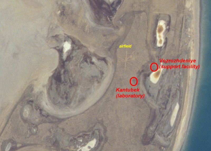
[Image: An aerial view of Kantubek, an abandoned town on Vozrozhdeniye Island; via Wikimedia].

The implied storylines here for future science fiction, or horror, films is totally out of control – and yet there is still more to learn about Vozrozhdeniye Island.
For instance: it’s no longer really an island.
The Aral Sea, in which Vozrozhdeniye sits, has been evaporating since the 1980s, due to catastrophically mismanaged Soviet irrigation plans – which means that Vozrozhdeniye is now a peninsula.
This otherwise unremarkable geographical shift has frightening implications:

Many of the containers holding the [biowarfare agents] were not properly stored or destroyed, and over the last decade many of the containers have developed leaks. As the Aral Sea continues to recede, the area will eventually connect further with the surrounding land. Many scientists fear that animals will move to the surrounding land and eventually carry these deadly biological agents out.

Such a scenario may sound far-fetched, but it’s worth pointing out that there was, indeed, an outbreak of smallpox in 1971 in the nearby city of Aralsk.
According to “a previously secret Soviet medical report,” which included “autopsy reports, pathology reports, containment tactics, and an official Soviet analysis of the outbreak’s source,” there were 10 cases of smallpox reported in Aralsk alone – after which “officials quarantined the city for weeks.”
In the process, “Homes and belongings were decontaminated or burned.”
Potential novelists or screenwriters might want to start paying attention here, though, because this is a near-perfect plot device.

The person believed to have introduced the virus to Aralsk was a young female ichthyologist who had just returned from a four-week research expedition on the Aral Sea aboard the Lev Berg, a small fishing boat. According to official documents, she was bed-ridden with a fever, headache, and muscle aches aboard the ship beginning Aug. 6, five days before returning to Aralsk on Aug. 11. Before public health officials diagnosed smallpox as the cause of her illness six weeks later, the young woman had exposed her nine-year-old brother, who had exposed others.

Even more interesting, this woman – referred to as Patient 1 – is still alive, and she disputes the official narrative of the outbreak. Nonetheless, it’s now more or less accepted that the woman’s ship must “have strayed too close to [Vozrozhdeniye Island] as smallpox viral particles, alighted on the wind by a Soviet weaponizing additive, floated across the ship’s decks, where Patient 1 netted fish day and night.”
You can read more about the outbreak at the website of Sandia Labs.
Finally, there was even speculation, back in 2001, that Vozrozhdeniye Island may have been distantly involved in the U.S. anthrax attacks.
But I could go on and on. If you want to know more, though, just follow the links, above, or check out CNN – and, if you’re a budding novelist, and you decide to go somewhere with this material, let me know!
And if you’re anywhere near the Aral Sea, beware the wind…

(Thanks to Neddal Ayad for pointing Vozrozhdeniye Island out to me!)

The town at risk from cave-ins

In what sounds like the plot of a bad horror film, we read that “kids in Picher, Okla., are exposed to lead, and the ground is at risk of cave-ins” due to the “abandoned mines beneath the city.”

Turns out the whole town is now under “voluntary buyout” by the US government because the place is so polluted that no one should be living there. Tailings from abandoned lead and zinc mines are to blame; indeed, there are “giant gray piles of mining waste, known locally as ‘chat,’ some hundreds of feet tall and acres wide, that loom over abandoned storefronts and empty lots.”

[Image: “Chat piles” looming round the “abandoned storefronts and empty lots” of Picher, OK; photo by Matt Wright, author of the article I’ve been quoting. See also this photo gallery from the US Geological Survey’s own tour of Picher, or this series of images from 1919].

From the Washington Post:

Signs of Picher’s impending death are everywhere. Many stores along Highway 69, the town’s main street, are empty, their windows coated with a layer of grime, virtually concealing the abandoned merchandise still on display. Trucks traveling along the highway are diverted around Picher for fear that the hollowed-out mines under the town would cause the streets to collapse under the weight of big rigs. (!) In some neighborhoods, empty mobile homes sit rusting in the sun, their windows broken, their doors yawning open, the detritus of life—car parts, broken toys, pieces of carpet, rotting sofas—strewn across their front yards.

But what happens in twenty years’ time, when a group of joy-riding teenagers from across state lines find themselves driving through Picher in the late afternoon…? They park their car, laughing, and throw rocks through some windows; one of them sneaks behind the old neighborhood Piggly Wiggly and opens up the door of a small shed only to find the entrance to a mine—when, suddenly, the ground opens up on the main street and swallows all three of his friends.

He hears screaming—as well as what sound like whispering voices coming from beneath the ground. The sun setting, our naive hero of the high school football squad descends into the lead mines to find them…

Or has that film already been made?

(Thanks, Javier! See also Helltown USA and Cancer Villages).

Tativille

[Image: Tativille; a scene from Playtime. As Jacques Tati later explained, “there were no stars in the film, or rather, the set was the star, at least at the beginning of the film. So I opted for the buildings, facades that were modern but of high quality because it’s not my business to criticise modern architecture” – it was only his job to film it].

The idea that an abandoned film set could be archaeologically mistaken for a real city, ten, twenty, even a thousand years in the future, has popped up on BLDGLBOG before.
However, it turns out that there’s an equally interesting story to be found in Tativille, the instant city and film set built for Jacques Tati‘s now legendary Playtime. “Tativille came into existence,” we read in this PDF, “on the ‘Ile de France’ on a huge stretch of waste ground [in Paris]”:

Conceived by Jacques Tati and designed by Eugene Roman, it was strictly a cinema town, born of the needs of the film: big blocks of dwellings, buildings of steel and glass, offices, tarmacked roads, carpark, airport and escalators. About 100 workers laboured ceaselessly for 5 months to construct this revolutionary studio with transparent partitions, which extended over 15,000 square metres. Each building was centrally heated by oil. Two electricity generators guaranteed the maintenance of artificial light on a permanent basis.

During pre-production, “Tati visited many factories and airports throughout Europe before his cinematographer Jean Badal came to the conclusion that he needed to build his own skyscraper. Which is exactly what he did.”
In fact, he built Tativille: an entire city inhabited by no one but actors – who left after each day of filming.
One estimate puts the total mass of built space and material at “11,700 square feet of glass, 38,700 square feet of plastic, 31,500 square feet of timber, and 486,000 square feet of concrete. Tativille had its own power plant and approach road, and building number one had its own working escalator.”
Those hoping to visit the set’s cinematically Romantic remains are out of luck: “I would like to have seen it retained – for the sake of young filmmakers,” Tati claimed, “but it was razed to the ground. Not a brick remains.”

[Image: Tativille; from Playtime].

Notes for future screenwriters (who credit BLDGBLOG): in the summer of 2009 a delightful Ph.D. candidate from Columbia University, studying architectural history and writing her thesis on the lost sets of mid-20th century French cinema, will fly to Paris for three months. There, she rents a flat near the Seine, sketches buildings in blue ink on cafe napkins, reads Manfredo Tafuri, then sets up her most important interviews – but all is not well. She has strange dreams at night; she thinks she’s being followed; she has a mysterious run-in at the Musée D’Orsay; and she begins to suspect, upon deeper research, that Tativille wasn’t destroyed after all… Till, one day, in a beautifully shot scene at the French National Library – all weird angles and reflective glass walls – our heroine discovers that a small note has been slipped into her jacket pocket.
The note is actually a map, however, with directions addressed solely to her.
For, outside the city, in an arson-plagued banlieue, an old cluster of import warehouses silently waits.
She takes the train – and a small pocket-knife.
Then, standing alone inside one of those warehouses, torch in hand, she finds –

(Thanks, Nicky, for the tip! Of earlier interest: City of the Pharaoh).

Urban Fossil Value

[Image: J.M. Gandy, speculations toward the ruins of John Soane’s Bank of England – but, again, how about speculations toward the Bank of England’s fossils…?]

As Hurricane Rita carves away at the Gulf shore, Galveston burns, buses explode outside Houston, and New Orleans refloods through badly built and incompletely repaired levees, I stumbled upon an old article, from 1998, about fossilized cities.

Millions of years from now, in geographical regions “entombed by tectonic disturbances,” entire cities – “the abandoned foundations, subways, roads and pipelines of our ever more extensive urban stratum” – will actually come to form “future trace fossils.”

These “future trace fossils,” the article says, form easily preserved systems that are “a lot more robust than [fossils] of the dinosaurs. They include roads, houses and foundations.”

And yet, for all that, only those cities “that were rapidly buried by floods or sandstorms” will be “preserved for posterity.”

Los Angeles, for instance, “is on an upward trajectory, pushed by pressure from the adjacent San Andreas Fault system, and is doomed to be eroded away entirely.” But if a city is flooded, buried in sand, or otherwise absorbed downward, “the stage is set to produce ideal pickling jars for cities. The urban strata of Amsterdam, New Orleans, Cairo and Venice could be buried wholesale – providing, that is, they can get over one more hurdle: the destructive power of the sea.”

It is often remarked in architectural circles how megalomaniacal Nazi architect Albert Speer came up with his so-called theory of ruin value, in which he proposed a new Romano-Fascist Berlin designed to look good as a ruin in thousands of years.

But that’s boring – let’s talk about cities fossilizing over millions of years.

Urban fossil value.

The already buried, subterranean undersides of our Tube-hollowed, war-bunkered modern cities “will be hard to obliterate. They will be altered, to be sure, and it is fascinating to speculate about what will happen to our very own addition to nature’s store of rocks and minerals, given a hundred million years, a little heat, some pressure (the weight of a kilometre or two of overlying sediment) and the catalytic, corrosive effect of the underground fluids in which all of these structures will be bathed.”

Who knew, for instance, that plastics, “which are made of long chains of subunits, might behave like some of the long-chain organic molecules in fossil plant twigs and branches, or the collagen in the fossilized skeletons of some marine invertebrates”? Who knew, in other words, that plastics will fossilize?

Indeed, “with a favourable concatenation of tectonics and sea level, our species could leave behind in a geological instant a much more striking record than the dinosaurs left in a hundred million years.”

Musicalizing the weather through landscape architecture

The idea of listening to a landscape – how to podcast a landscape, for instance – tends to be literally overlooked in favor of a site’s visual impact or even its smell. When I was in Greece a few years ago, for instance, hiking toward an abandoned village on Tilos, every step I took crushed wild onions, herbs, and different flowers, and a temporary envelope of scent, picked up by breezes, floated all around me as I walked uphill. I may not remember every single detail of what that path *looked* like – but I do remember how it *smelled*.
It was like hiking through salad.
In any case, you don’t often see people packing up the family car, or hopping onto a train, to tour Wales or the Green Mountains of Vermont so that they can listen to the hills – they’ll go out to look at autumn leaf colors, sure, or take photographs of spring wildflowers. But to go all the way to Wales so they can hear a particular autumn wind storm howling through the gorges, a storm that only lasts two days of every year? Specifically going somewhere to *listen to the landscape*.
Seasonal weather events and their sonic after-effects. The Great November Moan.
All of which brings me to the idea of sound mirrors.


Musicalizing a weather system through landscape architecture.
BLDGBLOG here proposes a series of sound mirrors to be built in a landscape with regular, annual wind phenomena. A distant gully, moaning at 2am every second week in October due to northern winds from Canada, has its low, droning, cliff-created reverb carefully echoed back up a chain of sound mirrors to supply natural soundscapes for the sleeping residents of nearby towns.
Or a crevasse that actually makes no sound at all has a sound mirror built nearby, which then amplifies and redirects the ambient air movements, coaxing out a tone – but only for the first week of March. Annually.
Landscape as saxophone.


It’s a question of interacting with the earth’s atmosphere through human geotechnical constructions. Through sound mirrors.
What you’d need: 1) Detailed meteorological charts of a region’s annual wind-flow patterns. 2) Sound mirrors. 3) A very large arts grant.
You could then musicalize the climate.
With exactly placed and arranged sound mirrors atop a mesa, for instance, deep inside a system of canyons – whether that’s in the Peak District or Utah’s Canyonlands National Park – or even in Rajasthan, or western Afghanistan – you could interact with the earth’s atmosphere to create music for two weeks every year, amplifying the natural sounds of seasonal air patterns.
People would come, camp out, check into hotels, open all their windows – and just listen to the landscaped echoes.


A few questions arise: in this context, does Stonehenge make any sounds? What if – and this is just a question – it was built not as a prehistoric astronomical device but as a *landscape wind instrument*? You’d be out there wandering around the Cotswolds, thinking oh – christ, it’s 5000 years ago and we’re lost, but: what’s that? I hear Stonehenge… And then you locate yourself.
Sonic landmark.
This raises the possibility of building smaller versions of these sound mirrors in urban neighborhoods so that, for instance, Berlin’s Prenzlauer Berg sounds different than Mitte, which sounds different than Kreuzberg – which sounds different than South Kensington, which is different than Gramercy Park… Etc.
You’d always know which district of the city you were in – even which city you were in, full stop – based on what the wind sounded like.
(Which reminds me of another idea: that, to attract people to a city without much going for it, you could *flavor the water supply*: make it taste like Doritos, for instance, and then sell that on huge billboards: buy your new home in Detroit, the water tastes like Doritos… the water tastes like tofurky…).
Second: is there a sonic signature to the US occupation of Baghdad? And I don’t mean rumbling Hummers and airplane engines, I mean what if all those Bremer walls –


– generate sounds during passing wind storms? All the American military bases of Iraq moaning at 3am as desert breezes pass by.
What does the occupation *sound like*?
A sonic taxonomy of architectural forms could begin…

Car park picturesque and the Texas tower


On a site that is rather amazingly drenched with typos, misspellings, and other grammatical errors, we found this call for developing a car park picturesque, or “landscaped tarmac for leisure” – surely the post-human car park could be retroverted for this…?
Meanwhile, for all you Maunsell Towers fans –


– there’s the Texas tower: 75 miles east of New Jersey, though now collapsed into the sea, it was “intended to provide advance warning of enemy air attacks,” as “part of the Distant Early Warning system (DEW line) encircling the United States and Canada.” It collapsed into the sea, however, and killed everyone on board. Archigram meets James Cameron’s Abyss.


So I’m writing this at the beginning of a month-long James Bond marathon on AMC-TV, and am thinking, in this context, how all of Bond’s villains seem really to be renegade techno-architectural contractors of some sort: you have that fake volcano movie, the hollow high-tech island of Dr. No, that stupid ice-city of the last (please!) Pierce Brosnan Bond, and what else was there – oh, Moonraker


– in a particularly aerospatial moment of villainous ambition. In any case, then it occurred to me: that’s exactly what Osama bin Laden is/was – he’s a contractor. He built highways.
Plus ça change: he’s an ultra-rightwing Bond villain.

Gunkanjima Island

[Image: Gunkanjima Island (via)].

“Off the westernmost coast of Japan,” we read, “is an island called ‘Gunkanjima’ that is hardly known even to the Japanese.”

Long ago, the island was nothing more than a small reef. Then in 1810, [with] the chance discovery of coal … people came to live here, and through coal mining the reef started to expand continuously. Befor [sic] long, the reef had grown into an artificial island of one kilometer (three quarters of a mile) in perimeter, with a population of 5300. Looming above the ocean, it appeared a concrete labyrinth of many-storied apartment houses and mining structures built closely together.

“Seen from the ocean,” the site continues, “the silhouette of the island closely resembled a battleship – so, the island came to be called Gunkanjima, or Battleship Island.”

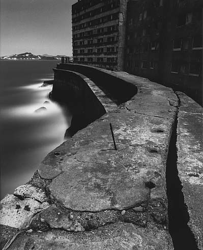
[Images: Gunkanjima Island (via)].

The idea of an entirely artificial mining island seems to lie somewhere between James Bond and Greek mythology. I’ve always wanted to write a short story about a mineral-rich island where a man similar to Conrad’s Kurtz sets up a mining operation; in mining the mineral wealth of his new little island, the architecture and structural engineering – the gantries, vaults, platforms, roads, etc. – come to be built from the island itself. Eventually the island entirely disappears beneath the waterline, mined down to nothing – and yet a small stilt-city of mining platforms, engineering decks, control rooms, and cantilevered walkways still exists there, built from the island it all now replaces.

[Image: Gunkanjima Island (via)].

In The Scar by China Miéville, there’s a floating city made from tightly lashed-together hulls of ships, built so densely that, for those deep within it, it appears simply to be a particularly over-built – albeit floating – island. The rudders and keels of old boats cut through the water at angles contrary to the direction that the ship-island floats in, and thousands of anchors secure the city in place when it needs to find harbor.

What seems to be missing, at least to my experience, from architectural history & design courses are things like – drum roll – offshore mining derricks. Once again, it seems the wrong people are teaching our design labs: instead of more M.Arch grads who’ve read too much – or not enough – Deleuze, we need to bring in junior executives from BP or Halliburton, geologists and NASA engineers, and put them into dialogue with Situationism – and, why not, with China Miéville. Science fiction writers. Get ideas out of the one side, practical engineering science out of the other, and shebang…

What could that produce…? is a legitimate question. A terrible example, but still marginally interesting I think, would be something like the Burning Man festival, thrown not in the desert but in the middle of the Atlantic Ocean. A joint-venture between BP, Halliburton, and Peter Cook of Archigram. And the Mars Homestead Project. Seaborne utopias. Platform cities. Perhaps Atlantis was built by a battalion of rogue Roman engineers lost to history.

[Image: Gunkanjima Island (via)].

It’s not Damien Hirst, Daniel Libeskind, Matthew Barney, or Norman Foster we should be watching, neither artistically nor architecturally, I mean; it’s the Chief Operating Officers of offshore oil-services firms. The architectural patrons of today are not avant-garde, middle class Connecticut home-owners but logistical managers in the US Department of Energy. New building types are not being discovered or invented in the design labs of American architectural offices, but in the flowcharts and budgetary projection worksheets of multinational petrochemical firms. Forget Spiral Jetty – we need a platform city built above the mid-Atlantic rift, an uninhabited, reinforced concrete archipelago ideal for untrained astronomical observation. The Reef Foundation – you win their residency grant and get to spend six months alone staring at the sun on a perfectly calibrated Quikrete lily pad.

We need the wastrel sons of hedge fund billionaires out there patronizing manmade archipelagos in the South China Sea.

We need more Gunkanjima Islands.

[Image: Gunkanjima Island (via)].