The Museum At The Bottom Of The Sea

[Image: Photo by Martin Siegel/Society of Maritime Archaeology, via Der Spiegel].

In 2012, German archaeologists began posting interpretive signs underwater, marking shipwrecks and even crashed airplanes at the bottom of the Baltic Sea as if they are in a museum, in order to make it clear to potential vandals, reckless tourists, and amateur collectors that these are culturally important sites, worthy of preservation.

“Alarmed at the looting of historically valuable shipwrecks in the Baltic Sea,” Der Spiegel reported at the time, “German archaeologists have started attaching underwater signs designating them as protected monuments. Hobby divers and trophy hunters are damaging a precious maritime legacy stretching back thousands of years, they warn.”

The sunken ship seen in the above image, for example, is just one of “some 1,500 marine monuments strewn across the seabed along the coast. The area has a wealth of well-preserved shipwrecks, lost cargo planes and even ancient settlements submerged through subsidence and rising water levels.” That these can be described as monuments is very important: they are not mere wreckage, scattered over the seabed, but artifacts on display for those who can reach them.

[Image: Photo by Martin Siegel/Society of Maritime Archaeology, via Der Spiegel].

The effect is strangely evocative, as if an architectural experiment has been going on beneath the waves of the Baltic Sea for the last few years, in which a museum, entirely without walls and seemingly with only very few visitors, has been secretly installed and constructed. It is a distributed, nonlinear museum of European ruins barely visible in the rising sea.

What’s so interesting from an architectural standpoint, however, is how a group of signs such as these can have such a huge narrative and spatial effect, as if you’ve entered some sort of undefined volumetric space without walls, hidden in the water all around you, a kind of invisible cultural institution stocked with objects that only you and your fellow divers, at that exact moment, can even see.

In fact, it makes me curious how the (totally brilliant and BLDGBLOG-supported) idea of creating a new National Park on the moon might work—and, more to the point, what such a park would really look like. Do we just post a few signs on the lunar surface indicating that historically important artifacts are present up ahead, or do we actually construct some sort of “museum” space there that would more adequately sustain an aura of cultural history?

Either way, it’s both hilarious and deeply strange that we could begin to experiment with what such a park might look like using—of all things—shipwrecks at the bottom of the Baltic Sea, and that German archaeologists, randomly posting cheap signs on the seabed, might have anticipated future strategies of historic preservation in otherwise deeply unearthly situations.

The Snow Mine

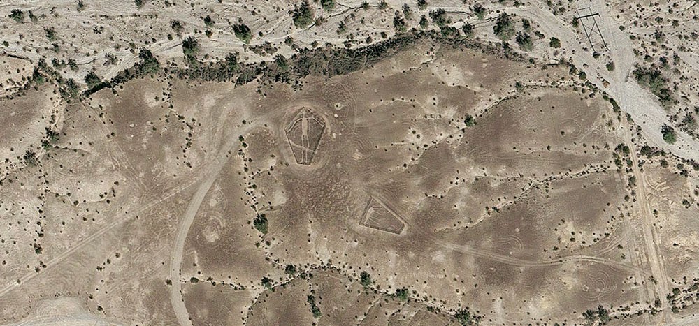
[Image: The “Blythe Intaglios,” via Google Maps].

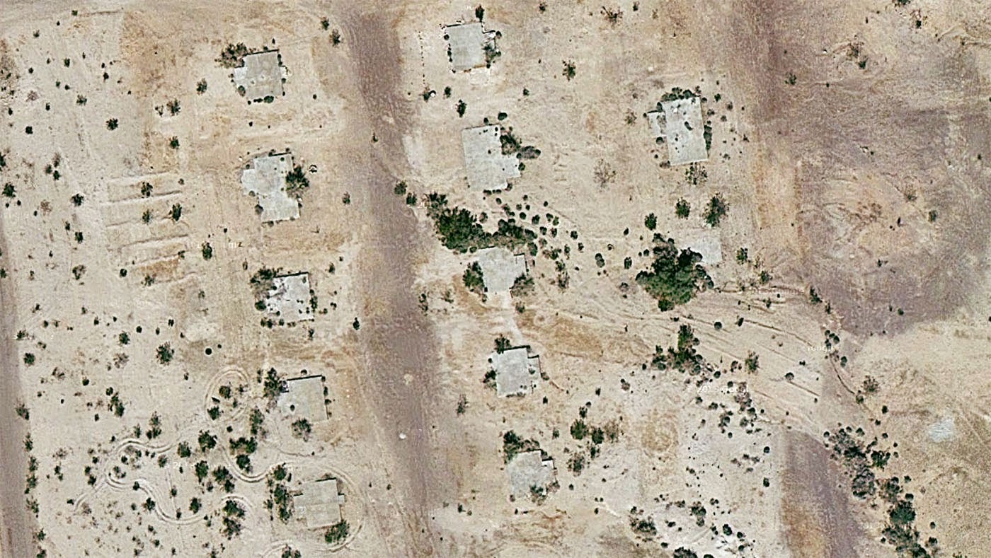
After reading an article about the “Blythe geoglyphs”—huge, 1,000-year old images carved into the California desert north of Blythe, near the border with Arizona—I got to looking around on Google Maps more or less at random and found what looked like a ghost town in the middle of nowhere, close to an old mine.

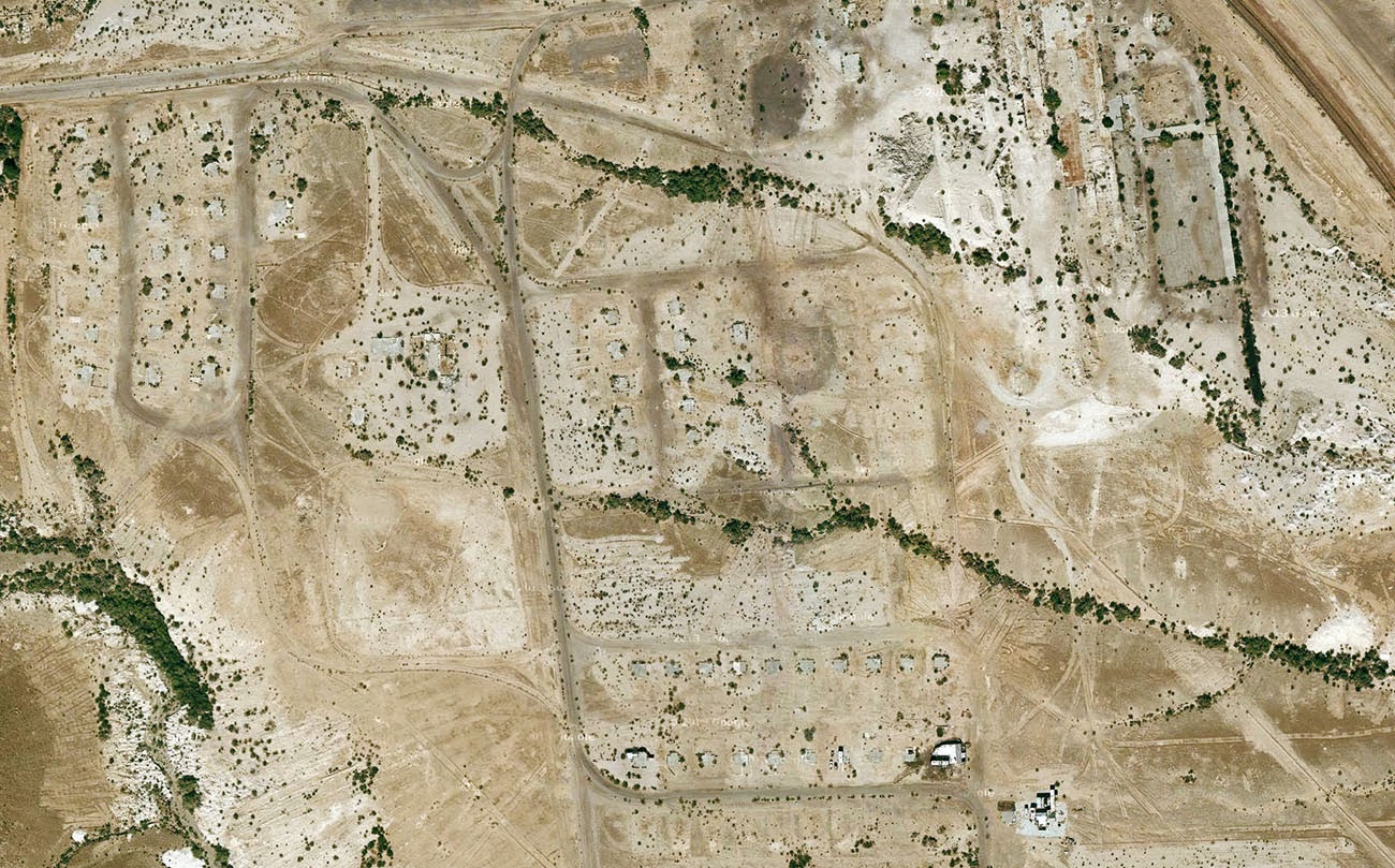
Turns out, it was the abandoned industrial settlement of Midland, California—and it’s been empty for nearly half a century, deliberately burned to the ground in 1966 when the nearby mine was closed.

[Image: Midland, California, via Google Maps].

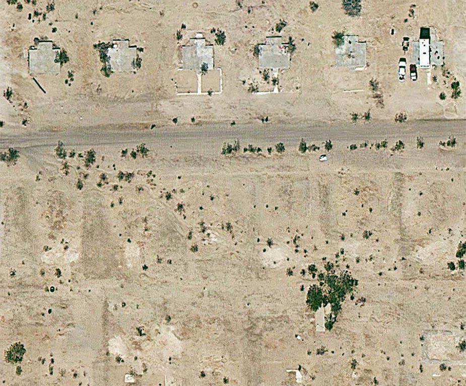
What’s so interesting about this place—aside from the exposed concrete foundation pads now reused as platforms for RVs, or the empty streets forming an altogether different kind of geoglyph, or even the obvious ease with which one can get there, simply following the aptly named Midland Road northeast from Blythe—is the fact that the town was built for workers at the gypsum mine, and that the gypsum extracted from the ground in Midland was then used as artificial snow in many Hollywood productions.

[Image: Midland, California, via Google Maps].

As the L.A. Times reported back in 1970—warning its readers, “Don’t Go To Midland—It’s Gone”—the town served as the mineral origin for Hollywood’s simulated weather effects.

“Midland was started in 1925 as a tent city,” the paper explained, “with miners in the middle of the Mojave Desert digging gypsum out of the Little Marias to meet the demands of movie studios. All the winter scenes during the golden age of Hollywood were filmed with ‘snowflakes’ from Midland.”

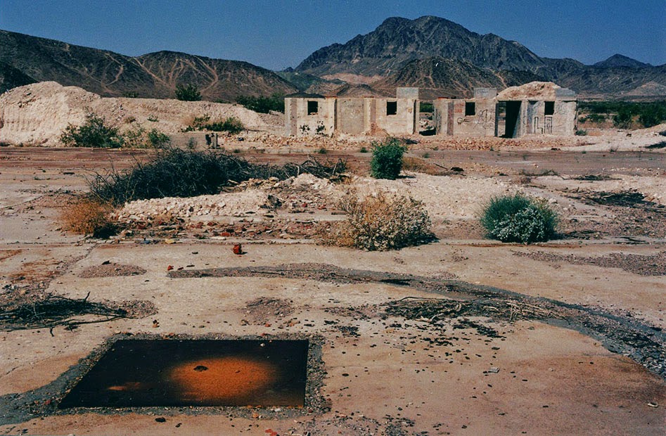
[Image: The abandoned streets of Midland, former origin of Hollywood’s artificial snow; photo via CLUI].

Like some strange, artificial winter being mined from the earth and scattered all over the dreams of cinemagoers around the world, Midland’s mineral snow had all the right qualities without any of the perishability or cold.

See, for example, this patent for artificial snow, filed in 1927 and approved in 1930, in which it is explained how gypsum can be dissolved by a specific acid mix to produce light, fluffy flakes perfect for the purposes of winter simulation. Easy to produce, with no risk of melting.

[Image: Midland, California, via Google Maps].

I’ve long been fascinated by the artificial snow industry—the notion of an industrially controlled climate-on-demand, spraying out snowflakes as if from a 3D printer, is just amazing to me—as well as with the unearthly world of mines, caves, and all things underground, but I had not really ever imagined that these interests might somehow come together someday, wherein fake glaciers and peaceful drifts of pure white snow were actually something scraped out of the planet by the extraction industry.

As if suggesting the plot of a deranged, Dr. Seussian children’s book, the idea that winter is something we pull from a mine in the middle of the California desert and then scatter over the warm Mediterranean cities of the coast is perhaps all the evidence you need that life is always already more dreamlike than you had previously believed possible.

(Very vaguely related: See also BLDGBLOG’s earlier coverage of California City).

A Pyramid in the Middle of Nowhere Built to Track the End of the World

[Image: Photo by Benjamin Halpern, courtesy of the U.S. Library of Congress].

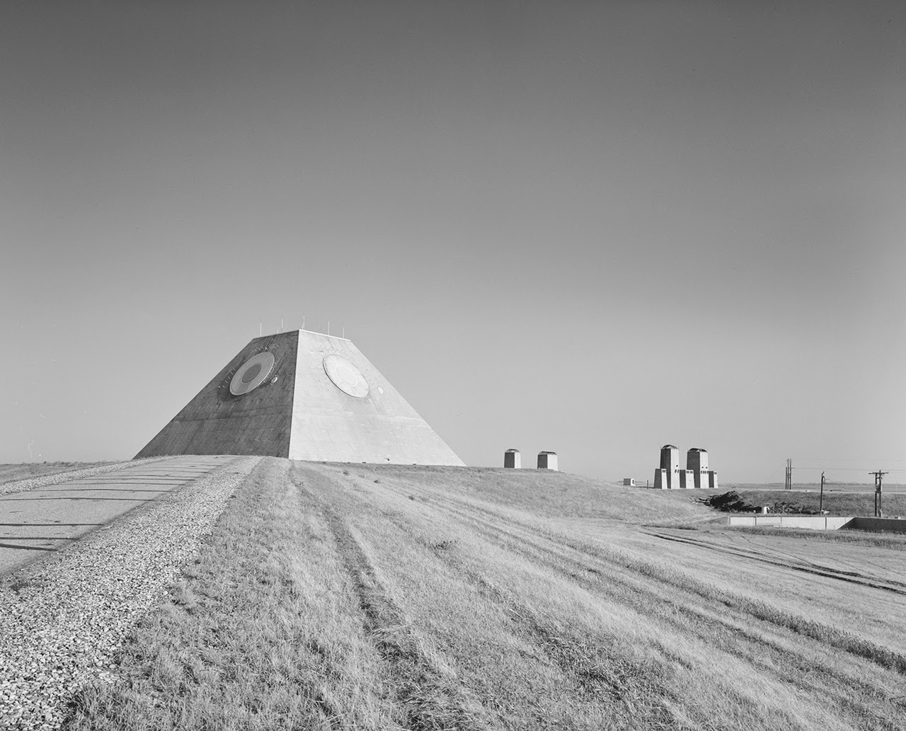
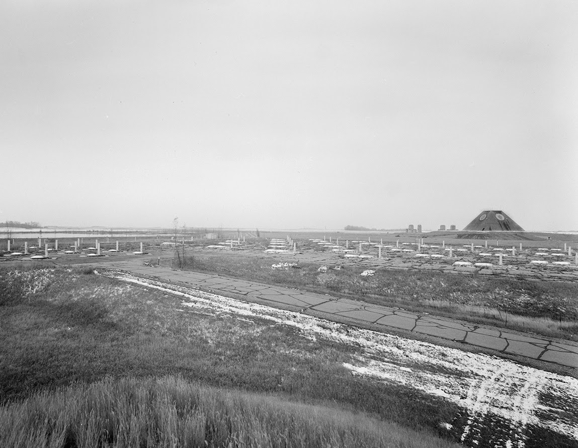
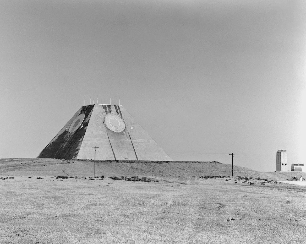
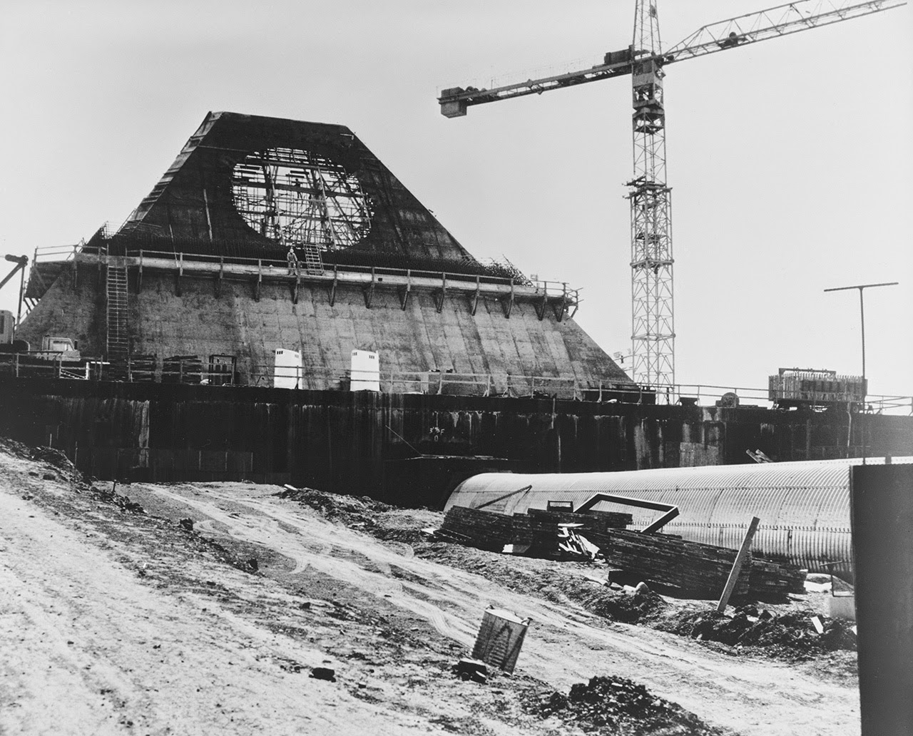
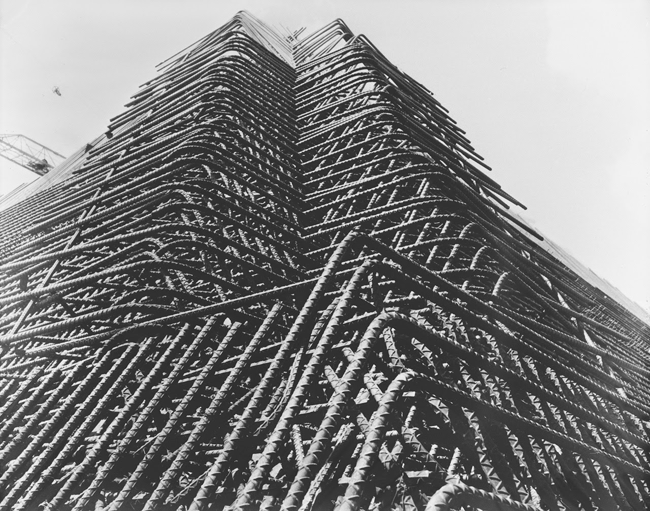
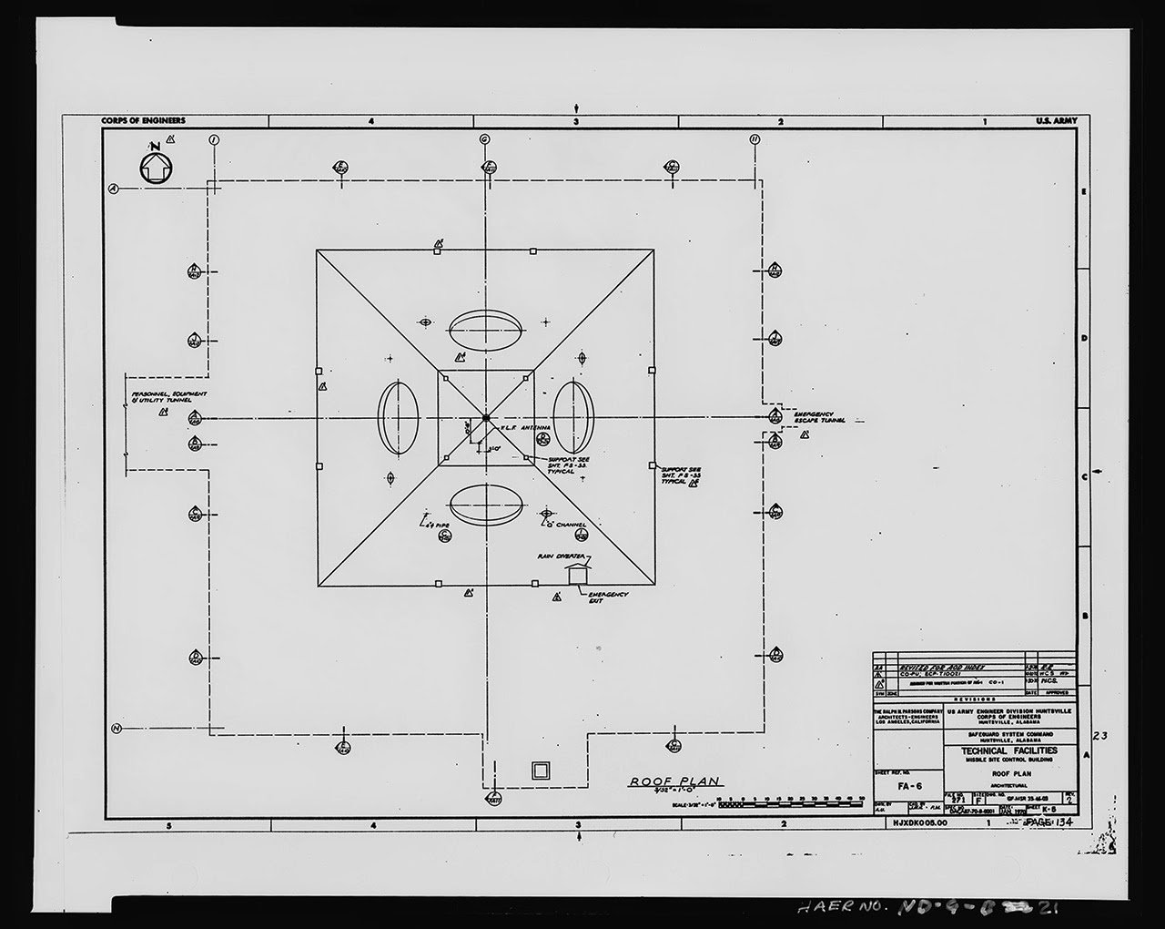
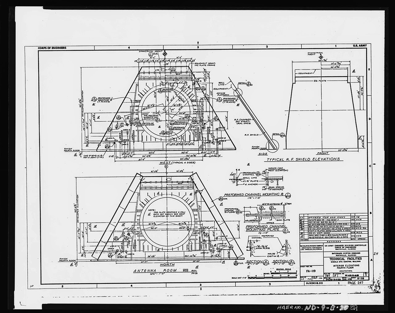
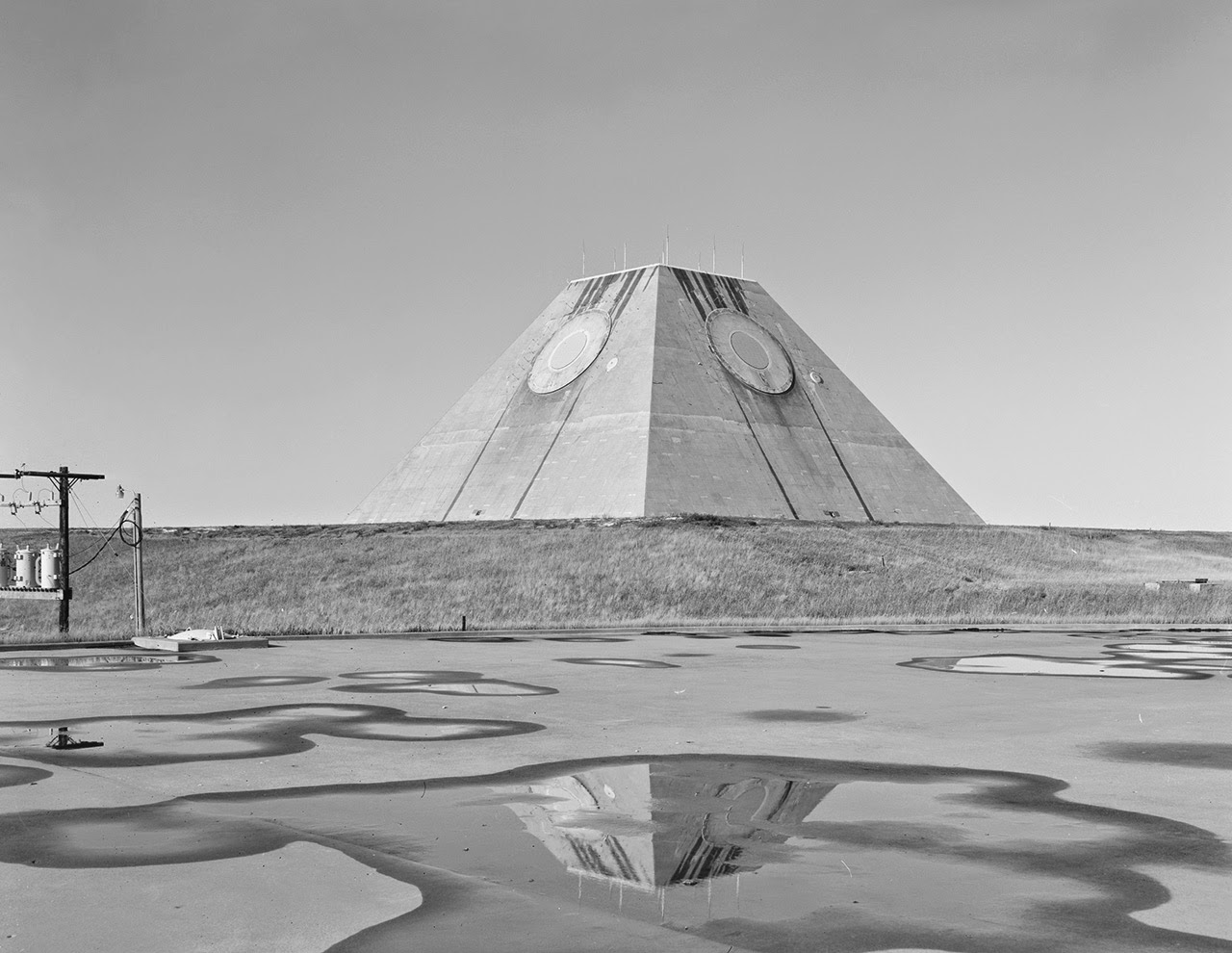
The Stanley R. Mickelsen Safeguard Complex in Cavalier County, North Dakota, is the focus of an amazing set of images hosted by the U.S. Library of Congress, showing this squat and evocative megastructure in various states of construction and completion.

It’s a huge pyramid in the middle of nowhere tracking the end of the world on radar, an abstract geometric shape beneath the sky without a human being in sight, or it could even be the opening scene of an apocalyptic science fiction film—but it’s just the U.S. military going about its business, building vast and other-worldly architectural structures that the civilian world only rarely sees.

[Images: Photos by Benjamin Halpern, courtesy of the U.S. Library of Congress].

As Pruned described these structures back in 2008, it was a “mastaba-shaped radar facility reminiscent of the work of architect Étienne-Louis Boullée.”

As such, Pruned suggests, it offers convincing architectural evidence that we should consider “the “U.S. anti-ballistic landscape as a subset of Land Art”—as lonely pieces of abandoned infrastructure isolated amidst sublime and almost unreachably remote locations.

[Images: Photos by Benjamin Halpern, courtesy of the U.S. Library of Congress].

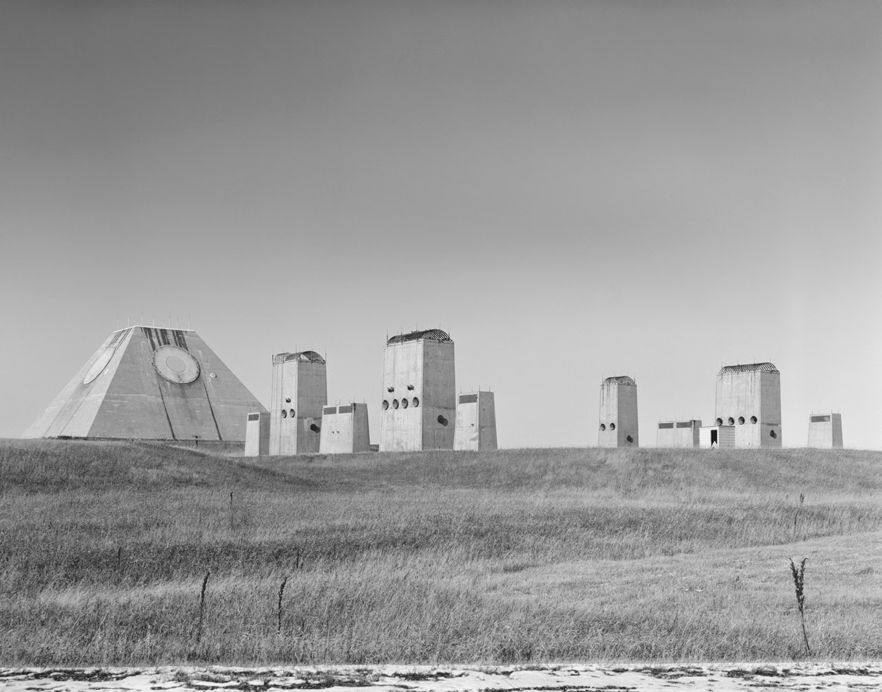
The photos seen here, taken for the U.S. government by photographer Benjamin Halpern, show the central pyramid—pyramid, monument, modular obelisk: whatever you want to call it—that served as the site’s missile-tracking station. Its omnidirectional all-seeing white circles stared endlessly at invisible airborne objects moving beyond the horizon.

The Library of Congress gives the pyramid’s location somewhat absurdly as “Northeast of Tactical Road; southeast of Tactical Road South.” In other words, it’s ensconced somewhere in a maze of self-reference and tautology, perhaps deliberately obscuring exactly how you’re meant to arrive at this place.

[Image: Photo by Benjamin Halpern, courtesy of the U.S. Library of Congress].

Yet the pyramid has become something of a roadtripper’s delight in the last decade or two. When I initially published a slightly different version of this post on Gizmodo, commenters from around the world jumped in with their own photos and memories of driving hours out of their way to find these military ruins looming spookily on the horizon.

Most if not all of them then discovered that it was as easy as simply saying hello to the guard, walking unencumbered through the front gate, and then hanging out for hours, running up the side of the pyramid, taking pictures against the North Dakota sky, and enjoying this American Giza as a peculiarly avant-garde site for an afternoon picnic.

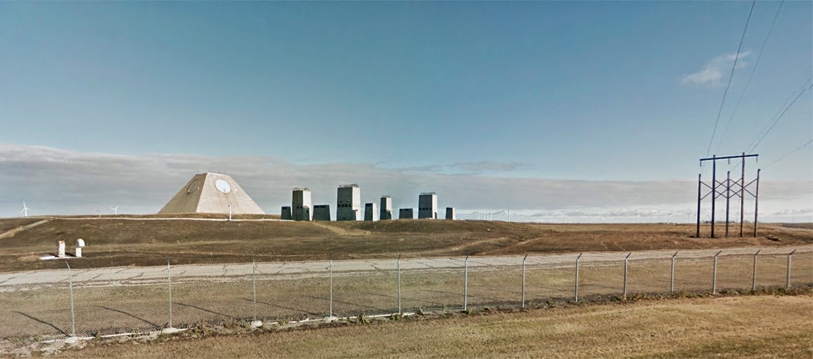
You can even see the structures, arranged like some ritual sequence of spatial objects—a chapel of radar aligned with war—on Google Street View.

[Image: The pyramid, seen somewhat jarringly in full color, via Google Street View].

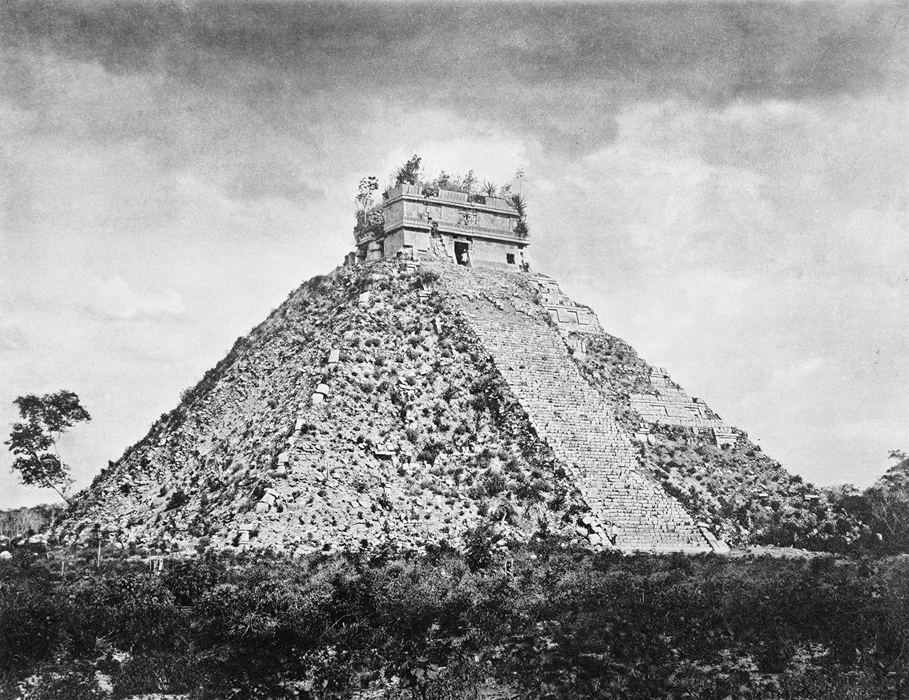
One thing I like so much about these shots is how they resemble early expeditionary photos of the hulking Mayan ruins found at Chichén Itzá.

Check out these comparative shots, for example, where the latter image was taken by photographer Henry Sweet during a 19th-century archaeological journey led by Alfred P. Maudslay. The photo was featured as part of an exhibition at the University of North Carolina back in 2007.

[Images: (top) Photo by Benjamin Halpern, courtesy of the U.S. Library of Congress; (bottom) photo by Henry Sweet, courtesy of the UNC-Chapel Hill].

Of course, there is nothing really to compare outside of their same overall geometry—yet it’s striking to consider the functional, if obviously metaphoric, similarities here as well. 

One structure was built as part of a kind of analogue system for tracking divine events and celestial calendars, as dark constellations of gods spun across the sky; the other was a temple to mathematics built for guiding and pinging missiles as they streaked horizon to horizon, a site of early warning against the apocalypse, as a new zodiac of nuclear warheads would burst open to shine their world-blinding light on the obliterated landscapes below. 

Trajectories, paths, horizons: both pyramids, in a sense, were architectural monuments for navigation of different kinds. Both timeless, strange, and seemingly inhuman: spatial artifacts of lost civilizations.

[Image: Photo by Benjamin Halpern, courtesy of the U.S. Library of Congress].

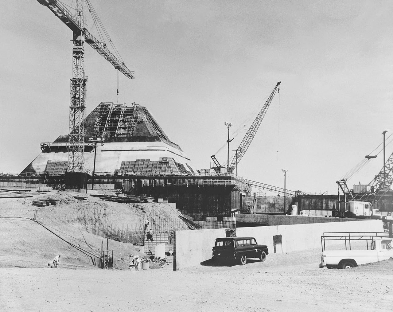
In any case, the original photos on the Library of Congress website are heavily specked with dust and some lens artifacts, but I’ve cleaned up my favorites and posted some of them here. 

[Images: Photos by Benjamin Halpern, courtesy of the U.S. Library of Congress].

This is how modern-day pyramids are made: huge budgets and ziggurats of rebar, as tiny figures wearing hardhats scramble around amidst gargantuan geometric forms, checking diagrams against reality and trying not to think of the nuclear war this structure was being built to track.

[Images: Photos by Benjamin Halpern, courtesy of the U.S. Library of Congress].

(An earlier version of this post previously appeared on Gizmodo).

Guided By Voices

At last week’s inaugural Infrastructure Observatory conference, MacroCity, archivist Rick Prelinger delivered a fantastic opening lecture looking back at the history of telephony in the Bay Area.

From the earliest exposed copper wires vulnerable to shorting out in San Francisco’s morning fog to 1970s phone phreaks and the future of NSA surveillance, it was a great talk; you can view the slides here (and follow Rick on Twitter for yet more).

[Image: From the Ellensburg Daily Record, June 16, 1914].

Amidst dozens of examples and images in his talk, the one that really stood out for architectural purposes was his citation of something called the “human telephone,” as originally reported in the Ellensburg Daily Record on June 16, 1914. A reorganized and cleaned-up version of that article appears above.

As Prelinger described it, the human telephone was like an electromagnetic update to the oracle at Delphi: a lone female figure with access to distant voices, dancing slowly across a dance floor secretly wired from below, an interactive surface whose hidden technology extended up into her very clothing.

There were copper wires woven through her dress, copper-soled shoes on her feet, even copper nails hammered in the floor below, and this all effectively turned her into a living telephone network—the “human telephone” of the article’s title—receiving voices from some continent-scale network invisible to spectators’ eyes. Oracular and alluring, she would then invite members of the audience to join her in this choreography, where ghostly conversations-at-a-distance would ensue.

[Image: An otherwise irrelevant photo of people ballroom dancing, via Wikipedia].

In Prelinger’s own words:

Prior to the opening of PPIE [the Panama Pacific International Exhibition], Pacific Telephone was asked to furnish service to the Ball of All Nations in May 1914. They built a hidden network of wires under the floor, connected with copper nails set close apart in the floor. The spouse of a telco employee wore copper-soled shoes from which wires ran up through her clothing to a telephone set. She asked her dancing partners whom they’d like to talk with, and suddenly they were on the phone. A switchboard operator listened in on all conversations and whenever she heard a name rushed through a call on special lines.

This wired ballroom—like some telephonic update of the khôra, that Platonic dance floor and moving surface so mythologically important to the first days of Western architecture—presents us with an absolutely incredible image of people waltzing amidst voices, metallurgically connected to a matrix of wires and lines extending far beyond the room they first met within.

The copper woman in the center of it all becomes more like an antenna, stepping and turning inside a glossolalia of distant personalities all vying for time on the invisible network she controls with every move of her feet. Sheathed in metal, she is part golem, part conjurer, part modern oracle, kicking off the weird seance that was the early telephone system, guiding us through a switchboard of words from nowhere all woven together in this awesome dance.

Wire-Tapping the Ruins of Pompeii

[Image: Alexander Graham Bell, inventor of the telephone, steps forth into the ruins of the “extinct city” of Pompeii; courtesy U.S. Library of Congress].

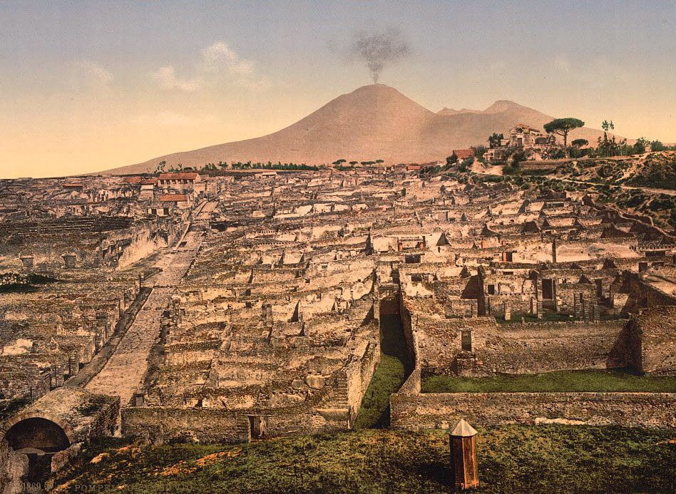
The ruins of Pompeii are being wired-up by a company otherwise known for its work as a manufacturer of military drones and “electronic warfare equipment,” Phys.org reports. Finmeccanica, the “Italian aerospace and defense giant,” has been contracted to install a high-tech sensor network amongst the barely stabilized walls and streets of this city once buried by a volcanic eruption nearly 2,000 years ago, in the hopes of monitoring unstable ground conditions on the sites.

Slippage and instability threaten to bring some of the buildings down, not just putting the site’s UNESCO-designated mansions at risk but potentially injuring (or worse) its annual hordes of international visitors.

[Image: General view of Pompeii and Mt. Vesuvius; courtesy U.S. Library of Congress].

In Phys.org’s words, the sensors are being installed “to assess ‘risks of hydrogeological instability’ at the sprawling site, boost security and test the solidity of structures, as well as set up an early warning system to flag up possible collapses.”

The results are a bit like electronic eavesdropping—a kind of NSA of the ruins—only, instead of wire-tapping a single phone line, the entire city of Pompeii will be listened to from within, hooked up from one side to the other with equipment so sensitive it is normally used in waging “electronic warfare.”

[Image: The Street of Tombs, Pompeii; courtesy U.S. Library of Congress].

The data will eventually be made available online for all to analyze, but it is interesting to read of a more immediate use of the sensors’ findings: Pompeii’s “security guards will be supplied with special radio equipment as well as smartphone apps to improve communication that can pinpoint their position and the type of intervention required.”

In other words, guards will receive electronic updates from the city itself while out on their daily rounds, including automated pings and alerts of impending structural failure or deformations of the ground, like some weird, semi-militarized version of ambient music, as if listening to the real-time groans of a settling city by radio.

Wire-tapping the ruins of a dead city, this mesh of electronic equipment—normally used in military surveillance operations—will thus help to preserve the archaeological site for future generations.

[Image: Fortuna Street, Pompeii; courtesy U.S. Library of Congress].

Like something out of Douglas Kahn’s recent book about the history of terrestrial electromagnetism and audio art, the old crumbling columns and shattered walls of Pompeii will soon find a new voice through repurposed military equipment, a weaponized seance performed on the empty streets of a place that’s more tomb than city.

[Image: The Forum, Pompeii; courtesy U.S. Library of Congress].

The possibilities for interactive apps and other touristic experiences are also mind-boggling here: imagine, at the very least, being able to walk into the center of Pompeii totally alone, with nothing but your phone and some earbuds, tuning into real-time broadcasts of the shuddering masonry all around you, a wireless archaeological orchestra of bleached monuments in the sun, listening from within to the sounds of the ancient city.

Distant HAM radio enthusiasts, tuning in from attics in Indiana, spin the dial every Saturday night hoping to find Pompeii, a destroyed city on the other side of the world with its own location in the ether, whistling and purring as its architecture falls apart, room by room, a catacomb of sound and destruction.

(An earlier, different version of this post first appeared on Gizmodo).

When Hills Hide Arches


Landforms masquerading as architecture and vice versa seem to dominate a few sets of older images hosted at the Library of Congress.

Photos taken between 1865 and 1872, these are—photographically speaking—almost impossibly ancient, approaching a point of chemical age as comparatively old to us today as the structures they depict were to the military expeditions that documented them in the first place.


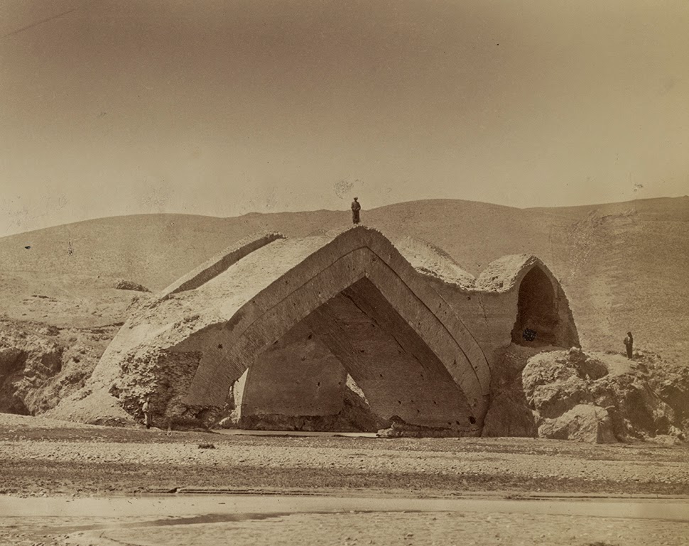
The first shot—depicting the “ruins of the Mulushki Mirza Rabat near Khodzhend,” as the Library of Congress explains it—establishes something of a theme here: works of architecture built from modules of fired clay, their wind-pocked brickwork extracted from the hills around them and transformed by kilns into something artificial, “manmade,” now more artifact than natural object.

Ironically, though, it is exactly their resemblance to the earth that sets the stage for these structures’ later decay, falling apart into mere dust and minerals, little pebbles and grains of sand, literally forming dunes, blending imperceptibly with the landscape. Once they’re gone, it’s as if they were never there.


Domes and extraordinary arches stand in the middle of nowhere, as if left behind by the receding tide of some alien civilization that once slid through, depositing works of architecture in its wake. Like the slime of a snail, these are just residue, empty proof that something much bigger once passed by.

What’s so amazing about these pictures, I’d suggest, is that, among other things, they come with the surreal implication that, beneath or somehow within all the rolling hills and dunes of the surrounding landscape, these sprawling bridges and spinal forms are actually hidden, just waiting there for hooded, 19th-century backpackers to rediscover.

These tiny figures are probably laughing in awe at the anti-gravitational urge that pushes these structures up above the sand line, into the photographs of these seemingly nameless expeditionary teams intent on cataloging every spatially exotic detail they find.


Here, in the ruins of Murza Rabat, seen below, natural hills are actually catacombs of architecture, buildings fooling us for their resemblance to caves, structurally camouflaged as the surface of the earth.

But it’s not the planet—it’s not geology—it’s just architecture: a shaped thing, an artifact, something plastic and formed by human hands. Not hills but abandoned buildings.


In the end, photographs of sand dunes might actually depict scenes of collapsed architecture; that landscape there in front of you might really be a city seen one thousand years after the fact, every wall cracked open and broken into pointless little mounds you’d probably stomp through without even thinking, the desert all around you giving no indication that this all used to be structure.

It used to be arches, bridges, vaults, and domes, huge mosques and cathedrals of human form before crumbling into mindless anthills of mud and clay.


It’s almost like these photographs exist to remind you that everything you now think of as a room—as space, as volume, as creation—will soon just be a suffocation of sand grains packed together in dense, amnesia-ridden hills, landscapes almost laughably quick to forget they once were architecture.

All photos courtesy of the Library of Congress.

Roentgen Objects, or: Devices Larger than the Rooms that Contain Them

[Image: Photo courtesy of the Rijksmuseum Amsterdam and the Metropolitan Museum of Art].

A gorgeous exhibition last year at the Metropolitan Museum of Art featured mechanical furniture designed by the father and son team, Abraham and David Roentgen: elaborate 18th-century technical devices disguised as desks and tables.

First, a quick bit of historical framing, courtesy of the Museum itself: “The meteoric rise of the workshop of Abraham Roentgen (1711–1793) and his son David (1743–1807) blazed across eighteenth-century continental Europe. From about 1742 to its closing in the early 1800s, the Roentgens’ innovative designs were combined with intriguing mechanical devices to revolutionize traditional French and English furniture types.”

Each piece, the Museum adds, was as much “an ingenious technical invention” as it was “a magnificent work of art,” an “elaborate mechanism” or series of “complicated mechanical devices” that sat waiting inside palaces and parlors for someone to come along and activate them.

If you can get past the visual styling of the furniture—after all, the dainty little details and inlays perhaps might not appeal to many BLDGBLOG readers—and concentrate instead only on the mechanical aspect of these designs, then there is something really incredible to be seen here.

[Image: Photo courtesy of the Rijksmuseum Amsterdam and the Metropolitan Museum of Art].

Hidden amidst drawers and sliding panels are keyholes, the proper turning of which results in other unseen drawers and deeper cabinets popping open, swinging out to reveal previously undetectable interiors.

But it doesn’t stop there. Further surfaces split in half to reveal yet more trays, files, and shelves that unlatch, swivel, and slide aside to expose entire other cantilevered parts of the furniture, materializing as if from nowhere on little rails and hinges.

Whole cubic feet of interior space are revealed in a flash of clacking wood flung forth on tracks and pulleys.

As the Museum phrases it, Abraham Roentgen’s “mechanical ingenuity” was “exemplified by the workings of the lower section” of one of the desks on display in the show: “when the key of the lower drawer is turned to the right, the side drawers spring open; if a button is pressed on the underside of these drawers, each swings aside to reveal three other drawers.”

And thus the sequence continues in bursts of self-expansion more reminiscent of a garden than a work of carpentry, a room full of wooden roses blooming in slow motion.

[Images: Photos courtesy of the Rijksmuseum Amsterdam and the Metropolitan Museum of Art].

The furniture is a process—an event—a seemingly endless sequence of new spatial conditions and states expanding outward into the room around it.

Each piece is a controlled explosion of carpentry with no real purpose other than to test the limits of volumetric self-demonstration, offering little in the way of useful storage space and simply showing off, performing, a spatial Olympics of shelves within shelves and spaces hiding spaces.

Sufficiently voluminous furniture becomes indistinguishable from a dream.

[Image: Photo courtesy of the Rijksmuseum Amsterdam and the Metropolitan Museum of Art].

What was so fascinating about the exhibition—and this can be seen, for example, in some of the short accompanying videos (a few of which are archived on the Metropolitan Museum of Art’s website)—is that you always seemed to have reached the final state, the fullest possible unfolding of the furniture, only for some other little keyhole to appear or some latch to be depressed in just the right way, and the thing just keeps on going, promising infinite possible expansions, as if a single piece of furniture could pop open into endless sub-spaces that are eventually larger than the room it is stored within.

The idea of furniture larger than the space that houses it is an extraordinary topological paradox, a spatial limit-case like black holes or event horizons, a state to which all furniture makers could—and should—aspire, devising a Roentgen object of infinite volumetric density.

A single desk that, when unfolded, is larger than the building around it, hiding its own internal rooms and corridors.

Suggesting that they, too, were thrilled by the other-worldly possibilities of their furniture, the Roentgens—and I love this so much!—also decorated their pieces with perspectival illusions.

[Image: Photo courtesy of the Rijksmuseum Amsterdam and the Metropolitan Museum of Art].

The top of a table might include, for example, the accurately rendered, gridded space of a drawing room, as if you were peering cinematically into a building located elsewhere; meanwhile, pop-up panels might include a checkerboard reference to other possible spaces that thus seemed to exist somewhere within or behind the furniture, lending each piece the feel of a portal or visual gateway into vast and multidimensional mansions tucked away inside.

The giddiness of it all—at least for me—was the implication that you could decorate a house with pieces of furniture; however, when unfolded to their maximum possible extent, these same objects might volumetrically increase the internal surface area of that house several times over, doubling, tripling, quadrupling its available volume. But it’s not magic or the supernatural—it’s not quadraturin—it’s just advanced carpentry, using millimeter-precise joinery and a constellation of unseen hinges.

[Images: Photos courtesy of the Rijksmuseum Amsterdam and the Metropolitan Museum of Art].

You could imagine, for example, a new type of house; it’s got a central service core lined with small elevators. Wooden boxes, perhaps four feet cubed, pass up and down inside the walls of the house, riding this network of dumbwaiters from floor to floor, where they occasionally stop, when a resident demands it. That resident then pops open the elevator door and begins to unfold the box inside, unlatching and expanding it outward into the room, this Roentgen object full of doors, drawers, and shelves, cantilevered panels, tabletops, and dividers.

And thus the elevators grow, simultaneously inside and outside, a liminal cabinetry both tumescent and architectural that fills up the space with spaces of its own, fractal super-furniture stretching through more than one room at a time and containing its own further rooms deep within it.

But then you reverse the process and go back through in the other direction, painstakingly shutting panels, locking drawers, pushing small boxes inside of larger boxes, and tucking it all up again, compressing it like a JPG back into the original, ultra-dense cube it all came from. You’re like some homebound god of superstrings tying up and hiding part of the universe so that others might someday rediscover it.

To have been around to drink coffee with the Roentgens and to discuss the delirious outer limits of furniture design would have been like talking to a family of cosmologists, diving deep into the quantum joinery of spatially impossible objects, something so far outside of mere cabinetry and woodwork that it almost forms a new class of industrial design. Alas, their workshop closed, their surviving objects today are limited in number, and the exhibition at the Metropolitan Museum of Art is now closed.

Spatial Delirium: An Interview with Michael Light

Michael Light, Gated “Monaco” Lake Las Vegas Homesites Looking West on Grand Corniche Drive, Bankrupt MonteLago Village and Ponte Vecchio Bridge Beyond, Henderson, Nevada (2010)

Photographer Michael Light divides his time between San Francisco and a remote house near Mono Lake, in the Sierra Nevada. An artist widely known for his aerial work, Light flies the trip himself in a small airplane, usually departing very early in the morning, near dawn, before the turbulence builds up.

Michael Light preps his airplane for flight; photo by Venue.

Venue, BLDGBLOG’s collaborative project with Nicola Twilley of Edible Geography and the Nevada Museum of Art’s Center for Art + Environment, not only had the pleasure of flying with Light around Mono Lake, but of staying in his home for a few nights and learning more, over the course of many long conversations, about his work.
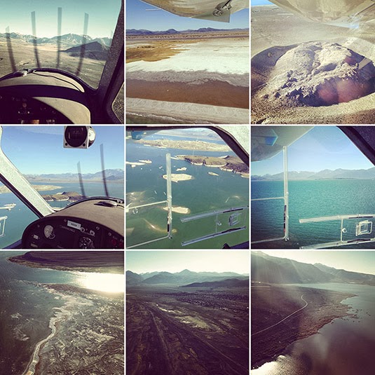
Flying with Michael Light over Mono Lake; photos by Venue.

We took a nighttime hike and hunted for scorpions in the underbrush; we looked at aerial maps of the surrounding area—in fact, most of the U.S. Southwest—to discuss the invisible marbling of military & civilian airspace in the region; and we asked Light about his many projects, their different landscape emphases, the future of photography as a pursuit and profession, and what he might work on next.

From SCUBA diving amidst the nuked ruins of WWII battleships in the most remote waters of the Pacific Ocean to spending years touching up and republishing photos of U.S. nuclear weapons tests for a spectacular and deeply unsettling book called 100 Suns, to his look at the Apollo program of the 1960s as an endeavor very much focused around the spatial experience of another landscape—the lunar surface—to his ongoing visual investigation of housing, urbanization, and rabid over-development in regions like Phoenix and Las Vegas, Light was never less than compelling.

With several great phrases—that “the mine is a city reversed,” or that the sunken ruins of WWII battleships “are dissolving like Alka-Seltzer” in the depths of the Pacific—and with an always caustic sense of humor, Light patiently answered our questions about his work both above the ground and below sea level, discussing what nuclear weapons have done the Western notion of the landscape sublime, what cameraphones have done to the professional photographer, and what it means to transgress today into the corporate-controlled air spaces of vast mining and extraction sites out west.

Michael Light, Shadow at 300’, 1300 hours, Deep Springs Valley, CA (2001)

• • •
Geoff Manaugh: I’d like to start by asking how the aerial view ties into the nature of your work in general. You’ve spoken to William L. Fox in an interview for the Some Dry Space exhibition about a feeling of spatial “delirium,” suggesting that the experience of moving through the sky is something viscerally attractive to you. I’m curious if you could talk about that, as a physical sensation, but also about the representational effects of the bird’s eye—or pilot’s eye—view and how it so thoroughly changes the appearance of a landscape.

Michael Light, Clouds Over the Jonah Natural Gas Field, Pinedale, WY (2007)

Michael Light: The short answer is that the aerial view affords a breadth of scale that offers direct access to many of the bigger, more “meta” themes that have always been of interest to me.

But let me take a few steps back and try to explain where all this came from. I got a B.A. in American Studies from Amherst many years ago, and I have since been an Americanist—not in the sense of being an apologist for America, but in the sense of someone trying to figure out what makes this country tick. It is a very, very vast country.

Michael Light, Sheep Hole Mountains at 400’, 0700 hours, Twentynine Palms, CA (2000)

I grew up on the end of Long Island, and I was always getting onto Highway 80 or onto more southerly interstates and heading west. The metaphor that always accompanied me, oddly enough, was one of falling into America rather than crossing it. I was falling into the vastness of America and the sheer scale of it.

Of course, after I moved to California in 1986, I caught myself coming back east quite a bit, for family or for work, and those commercial air flights across the nation, flying coast to coast, were formative and endlessly interesting to me. I don’t ever lower the window shade as requested. If the weather is clear, the odds are that what’s unfolding below, geologically, is the main attraction for me. I just found myself looking down—or looking into—America a lot, and that sense of falling into the country just grew and evolved.

I did a big piece back in the 1990s, when I was still in graduate school. It took a couple of years, but I figured out how to make pretty decent images from 30,000 feet, from the seat of a commercial airliner. For instance, you have to sit in front of the engine so that the heat doesn’t blow the picture; and it’s a contrast game, trying to get enough clarity through all the atmospheric haze and through two layers of plexiglass, and so on and so forth. That piece was based specifically on commercial flights and it was liberating for me in lots of ways.

While working on one of those images, in particular, I had something of an epiphany—I think it was somewhere over Arizona. It’s very spare, arid country, and the incursions of human settlement into it that you see from above look very much like a colony on Mars might look, or the proverbial lunar colony, and I thought “Ah ha! Look at that!” And I realized, at that moment, that maybe I could try to find or document something like a planetary landscape: the way humans live at a planetary scale and through planetary settlements.

Michael Light, Chidago Canyon at 500’, 1800 hours, Chalfant, CA (2001)

This was what got me, pretty soon thereafter, thinking above and beyond the earth: looking toward NASA, and their various programs over the past few decades, and that eventually became Full Moon.

FULL MOON: Composite of David Scott Seen Twice on Hadley Delta Mountain; Photographed by James Irwin, Apollo 15, 1971 (1999)

Manaugh: There’s an interesting book called Moondust by Andrew Smith, which began with Smith’s realization that we are soon approaching an historical moment when every human being who has walked on the moon will be dead. He set about trying to interview every living person—every American astronaut—who has set foot there. What makes it especially fascinating is that Smith portrays the entire Apollo program as a kind of vast landscape project, or act of landscape exploration, as if the whole thing had really just been at attempt at staging a real-life Caspar David Friedrich painting with seemingly endless Cold War funds to back it up. The place of Full Moon in your own work seems to echo that idea, of NASA lunar photography as something like the apotheosis of American natural landscape photography.

Light: The Apollo program was absolutely a landscape project—but also an extreme aerial project. And Full Moon, of course, was also driven by my own interest in the aerial view, or the aerial exterior. That project is nothing if not a really serious exploration of the aerial: that is, if you keep going up and up, the world becomes quite circular and alien. You see the world quite literally as a planet.

FULL MOON: The Ocean of Storms and the Known Sea; Photographed by Kenneth Mattingly, Apollo 16, April 16-27, 1972 (1999)

Anyway, for me, yes, the aerial view has an intense physicality. I’ve been flying planes since before I was driving. I soloed in gliders—engineless aircraft—by 14, and, by 16, I had a private pilot’s license. A glider offers a particularly intimate and very physical way of flying, because you have to work with thermals and updrafts. You don’t have an engine. You actually want it to be turbulent and bumpy up there, because that means that the air is unstable—that parts of the atmosphere are going up and other parts are going down—and, if you can stay in those up parts and find the updrafts, then you can ride it out for hours.

Also, I was lucky enough to start SCUBA diving at the age of 9.

Michael Light at 9 years old, Bimini, Bahamas (1972)

Flying and going underwater are completely connected, at least in my mind. The three-dimensionality of each of them is something I’ve experienced from a very early age, and it is one of my greatest ongoing pleasures. I would say that there’s a tremendous amount of physical pleasure in both—and that, occasionally, it would even be accurate to call it ecstasy.

It’s like skiing or long-distance running: everything’s in the groove, everything sort of falls into place, you’re flying really beautifully, or, oftentimes in my work, you’re transgressing over something, or you’ve got a very intense subject, and you are trying to figure something out as an artist or as a citizen.

Michael Light at 49 years old, Petaluma, CA (2012)

You mentioned delirium. There’s also a certain kind of delirium—a spatial delirium, sure—simply in the pleasure of learning something new and, for me, hopefully putting that 3-dimensional experience into 2-dimensional photographic form. And if it’s good—if the image is good—then hopefully other people can get some of what I got.

Manaugh: This reminds me of a conversation I had with a writer named Kitty Hauser about the history of aerial archaeology. To make a long story short, aerial archaeology, using photographs, was born from military reconnaissance flights over the European front in World War I. The pilots there began noticing that they could see features in the landscape—such as buried or ruined buildings—that were invisible from the ground. When that technique of viewing from above was later exported to England, particularly as the leisure classes and retired military types found the free time and the personal wealth to purchase private airplanes, aerial archaeology as a pursuit really took off, if you’ll excuse the pun. And these early pioneers began to realize that, for example, there are certain times of day when things are more clearly revealed by the angle of the sun, including shadows appearing in wheat and barley fields that, when seen from above, are revealed to be an archaeological site otherwise hidden beneath the plant life. I’m curious how coming back to the same locations at certain times of day, or in certain kinds of light, can make sites or landscapes into radically different photographic experiences—with different depths or different reliefs—and how you plan for that in your shots.

Light: If I go out on an expedition for weeks shooting with an assistant, I don’t immediately fall into that groove. A few days in, everything will align. It certainly is a kind of discipline. You’re flying and imaging and circling—again and again and again, around and around and around—because you can’t just move the camera two inches to the left, or wait 15 minutes. You’re moving along at 60 miles an hour through space. So you have to shoot it again and again and again, until, finally, you get to a point where your physical senses are moving faster than your mind, and you’ve made all the shots that you think you should make—which are generally the worst ones—and it’s at that point that you come up with something genuinely new.

Specifically, I tend to shoot early in the morning and then again in the evening, which is pretty much standard practice because, of course, the lower axial light gives that 3-dimensionality and creates a feeling of revelation. Every once in a while, though, I will shoot in the desert at midday, but it’s usually only when I’m specifically seeking a flat, blown out, almost stunning or hallucinatory light.

Michael Light, Deep Springs Valley at 500’, 1600 hours, Big Pine, CA (2001)

But, early in the morning, the sun seems to go off in the desert like a gun—and, of course, the sun is much softer in the evening, because there’s so much more dust in the air. You really have to get up early. I’ll shoot for an hour and a half, which is all I can really take with the doors off of the aircraft. It’s very windy. It’s very intense. The camera I use is about 20 pounds. So we’ll come back and we’ll have some breakfast—and I’m exhausted. I’ll probably nap around noon for an hour or two then, come 4:00pm or so, we gather our forces and go back up.

It’s always much more turbulent in the afternoon in summer. Summer is when I tend to fly, though, because, of course, in the colder months it’s just too cold. It’s also just a lot more dangerous to cross the mountains when there’s snow on them.

But, on summer afternoons, it can be a wild ride. You strap in there tight. My glider background is helpful here; I know the plane will continue to fly, for instance, and that there’s nothing to be super-scared of. I know I’m at the edges of my equipment’s performance. The specifications on the plane degrade measurably when you take the doors off, because you generate a tremendous amount of drag. In hot temperatures, the engine also tends to run hot and, the hotter the summer air is, the fewer molecules there are under the wings of the aircraft, the fewer molecules there are to combust with the engine fuel, the fewer molecules there are for the propeller to bite into, and you get much more turbulent air. Your aircraft performance falls off measurably.

Michael Light, Afternoon Thunderstorm Looking West, Near Rock Springs, WY (2007)

For example, I often fly from San Francisco over the Sierras to Mono Lake in the summer. The Sierras, on the west side, have a very gradual slope. But on the east side it’s a very dramatic, very steep escarpment. It’s a drop of 7,000 feet almost in a straight line. You have a very smooth, very fast trip up the western slope, but, when you get to the escarpment, you hit what’s called a “rotor.” That’s a very turbulent place where the usual land-to-airflow relationship completely falls apart, because the support has been taken away. For those five miles or so, going east, you’re in a tumbly, sometimes chaotic atmosphere and it can be extremely dangerous, depending on the speed of the wind.

When I hit the rotor, I just think of it in terms of river rafting: looking for eddies, back-flow currents, whirlpools, and so forth. Even though it’s invisible, I know where I’m going to hit turbulence. Even though I can’t see the air, I know, extrapolating from the way that water behaves, where the turbulence will be—like, beyond that rock mountain spire over there, it’s going to be gnarly.

Michael Light, City-Owned Motocross Park Looking North, I-70 Beyond, Lakewood, CO (2009)

To go back to your question: in the six, almost seven years I’ve been flying with engines, the landscape is so perceptually dependent on the type of light that’s illuminating it. You really do get radically different spaces in different kinds of light. A different kind of vibe. Seasons will also change the way a landscape looks—or, I should say, the light itself seasonally changes.

On an artistic level, the ever-changing nature of what I do and how I do it, and even the instability of my position in the sky over the landscape—it’s all part of my process and it’s something I enjoy.

Manaugh: Let’s go back to SCUBA diving. When we talked four or five years ago in Nevada, you were heading off to the Bikini Atoll, to dive amidst the ruins of U.S. warships, and I’d love to learn more about that project. How did it come about, what were you seeking to document, and what were the results? I’m also fascinated by analogy of being in the empty volume of the sky versus being buried in the very full volume of the ocean and how that affects the sense of space in your photography.

Light: The Bikini work grew out of my earlier involvement with imagery of nuclear detonations, which, as you know, was a project called 100 Suns. That was an archival endeavor that came out in 2003.

100 Suns (2003)

As a photographer or maker of images, I’m always as interested in trying to figure out the meaning of the trillions of photographs that have already been made as I am in making new ones of my own. And, culturally, I find it interesting to think about the meaning of photography, in the very large American contexts of Full Moon and 100 Suns. I think of both projects as landscape projects and, certainly, they are also investigations into American power and the peculiarities of American scale.

Nicola Twilley: As a side note, how does an archival project like 100 Suns work, technically, as far as reproducing the images goes?

Light: You scan them. You go in and you clean them up. You do whatever the approach of the hour is. You wind up almost lovingly inside each of the historical photographs. And you get very fond of them; you think of them almost as your own. Of course, they’re not—primarily because you haven’t had the experience of actually going to that space at that particular time and choosing how to make that image.

But I had a very strong desire to go—to make a pilgrimage—to, if not the Nevada Test Site, which I never could get into, then at least to the Pacific Proving Grounds, which I could get to. I tried to get into the Nevada Test Site. You can visit it, physically, but to get over it—in the air—and to make images is basically impossible. The last person to get permission to do that was Emmet Gowin, with his remarkable images. He got in in the 1990s. It took him a decade, and that was before 9/11. I tried again, and I was negotiating directly with the head of the site, but I just could never do it.

However, one can get out to Bikini, and the way one gets to Bikini hasn’t changed. At the time I went, there was a dive operation there run by the people of Bikini—who actually live 500 miles away, on a rather awful rock without a lagoon, in a place that they were moved to in 1945. They were basically booted off their atoll by the U.S. government. The people run this dive operation really for propaganda reasons, using it as a method to tell their story.

Michael Light, Bikini Island, Radioactively Uninhabitable Since 1954, Bikini Atoll (2003)

What one goes to dive for there are ships that were sunk in the Operation Crossroads tests of 1946.

At that point, the U.S. Navy—this was, of course, right after Hiroshima and Nagasaki—wanted to know if naval warfare was now utterly obsolete. Could a single bomb destroy an entire navy or a flotilla of ships?

100 SUNS: 058 BAKER/21 kilotons/Bikini Atoll/1946 (2003)

So they gathered almost 100 vessels for the tests, making all sorts of strange, mythic gestures. For instance, they brought the Nagato, which Admiral Yamamoto was on when he orchestrated the attack on Pearl Harbor. They brought that all the way from Tokyo. They brought out the Prinz Eugen from Germany, which was Germany’s most modern battleship. They brought the first American aircraft carrier, the U.S.S. Saratoga, out.

The ships they chose were these giant wartime icons, and they were bombed both from the air, with the Able test, and from 90 feet underwater, by the Baker test. The Baker test gave us the most spectacularly iconic images of Bikini: a water column being blasted up into the sky with the Wilson bell cloud around it that we all know so well.

100 SUNS: 059 BAKER/21 kilotons/Bikini Atoll/1946 (2003)

Those ships are 180 feet down at the bottom of Bikini Lagoon, to this day. They were functional at the time, and they were fully loaded with weaponry and fuel. They were unpopulated, although there were farm animals chained to the decks of the ships. So it’s creepy.

Diving there is pretty hairy. It’s way beyond recreational safety diving limits. 180 feet is dark. 180 feet is cold. You take on a tremendous amount of nitrogen down there. It’s pretty technical. You have to do decompression diving, which is inherently dangerous—you have to breathe helium trimix at about thirty feet below the boat for nearly an hour after twenty minutes at depth, hoping that no tiger shark comes along to eat you, as you adjust.

Michael Light, Shark, Bikini Lagoon (2007)

Once you’re down there, you can penetrate the ships, which are dissolving like Alka-Seltzer. It’s very entropic. You’re suffering, at that depth, from nitrogen narcosis. It’s like having three martinis. You’re pretty zonked out.

I went twice: in 2003 and, again, in 2007. During those trips, I made images from the air, on the surface, and underwater. I dove Bikini Lagoon, down to those ships on the bottom, twice.

Michael Light, Diver descending to 180 feet, Bikini Lagoon (2007)

It was one of the most challenging landscapes I have ever worked in, because almost inconceivable violence occurred to these places—both to Bikini Atoll and to Enewetak Atoll. I only physically went to Bikini Atoll, although I did fly over Enewetak. But both atolls were subjected to human gestures that are, as I said, almost inconceivably violent. To try to represent that photographically is very, very difficult.

In fact, the radiological disaster that occurred in 1954 happened simply because the winds changed direction at the wrong time, blowing back over the atoll at Bikini. During the largest nuclear detonation the United States ever did out there, which was 15 megatons, the winds shifted and everything blew back over the islands. It’s the worst radiological disaster in U.S. history.

Manaugh: I don’t want to sound naïve, but is it safe even to be there? Can you walk around and swim in the water and not get radiation poisoning?

Light: Bikini Atoll is still radioactive and still uninhabited to this day, but, yes, you can go there. As long as you don’t drink the water or eat the coconuts—anything that actually comes in contact with the soil, which has a layer of Cesium-137 in it—then you’re fine. The islands have healed. You know, it’s tropical. They’ve healed. There aren’t five-headed crabs walking around. The fish are fine; you can eat the fish. But it’s still pretty radioactive. I’m walking around in a Speedo bathing suit, thinking, “Wow, I’m glad I’m never having kids, ever!” You can’t feel radiation, but it’s there.

So there you are, having a tropical paradise moment, surrounded by tropical paradise visuals, yet you know, in your head, that this is one of the most violent landscapes on earth.

100 SUNS: 086 MOHAWK/360 kilotons/Enewetak Atoll/1956 (2003)

Two commercial aircraft fly the Marshall Islands. There is no access to private aircraft. The distances are too great. Bikini and Enewetak are in the middle of nowhere—that’s why they were used as test sites in the first place. To get aerial access to them was extremely difficult. I had to shoot from those two commercial air shuttles.

Over Enewetak I was able to get some pretty great images of the Mike crater. Mike was the first H-bomb test or, I should say, the first test of a “thermonuclear device.” It was not a bomb.

Michael Light, Mile-Wide, 200’ Deep 1952 MIKE Crater, 10.4 Megatons, Enewetak Atoll (2003)

That was Edward Teller’s baby, and one big-ass crater. That was 10.4 megatons. The scale of that kind of explosion dwarfs all of the ordinance detonated in both world wars combined. Five seconds after that detonation, the fireball alone was five miles wide. These were really, really big explosions. It’s hard to get your head around how big they were.

100 SUNS: 065 MIKE/10.4 megatons/Enewetak Atoll/1952 (2003)

Getting above and working with the Mike crater was terrific. I was able to get above Bikini, but not above the Bravo crater or out to the farthest edge of the atoll. Bravo was the 15-megaton test that left Bikini radioactive.

100 SUNS: 099 BRAVO/15 megatons/Bikini Atoll/1954 (2003)

However, I was able to dive in the Bravo crater while I was there, which was one of the creepiest experiences of my life. It’s still quite radioactive out on the edge of the crater. There’s a bunker right on the edge of Bravo Crater that’s sheared off at the top.

Michael Light, Radioactive Bunker Facing Mile-Wide, 200’ Deep 1954 BRAVO Crater, Bikini Atoll (2003)

Anyway, it’s obviously very deep and very rich territory. It was pretty amazing to be able to make the pilgrimage after having spent so much time with the archival material as I worked on 100 Suns. I have always felt ambivalent about the Bikini work. I’ve never known quite what to do with it. It is hard to work out there. I think that, ultimately, I will do a small book that will move between historical imagery of the ships and of the servicemen. There were 40,000 servicemen stationed there for several years while the Crossroads tests were happening.

I went back in 2007—I think that was right after you and I first talked about this. I got to do some aerial work and some more work on the ground, but, primarily, that trip was about bringing out a digital camera, which I did not have in 2003, and using it underwater. I had a housing and some lights, but I was not very successful in imaging those ships recognizably at those depths. It’s hard.

Michael Light, Ship Sunk by 1946 Crossroads Tests, Bikini Lagoon (2007)

There’s a lot of organic matter in the water. It’s incredibly dark. It’s very difficult to figure out, conceptually, a way to image the country’s first aircraft carrier. For example, I can’t back away from it enough, underwater, to get the whole thing. In theory, one could put together composite images, shot at a fairly close level, and then sort of stitch together what should look like a ship. But it’s a challenge.

Michael Light, Growth on Ship Sunk By 1946 Crossroads Tests, Bikini Lagoon (2007)

For me, throughout the Bikini work, both in 2003 and in 2007, I have taken the approach of reversing the positive as a conceit toward a sense of visually representing radiation and visually suggesting multiple energy sources other than the sun—multiple sources of light. There are also questions about narrative: about entropy, light, Hades, narcosis, dissolution.

You’ve got this kind of X-ray death trip, if you will.

Michael Light, Tower of the IJN Nagato Battleship, Sunk By 1946 Crossroads Tests, Bikini Lagoon (2007)

It’s a very, very strong feeling, diving amongst those ships, and the ghosts of all the people who died on those ships, and knowing what they were used for and how they were sunk. It almost feels like the last gasp of an industrial era that’s now long over and gone. It was really an age of iron. It’s as far from the digital world that we live in now that you can imagine. It’s a dead era, and the work is tough. It’s not warm and fuzzy, or nostalgic. None of that is what Bikini is about. It’s about as dark as you can get.

Michael Light, Along the USS Saratoga, Sunk By 1946 Crossroads Tests, Bikini Lagoon (2007)

Manaugh: In the context of 100 Suns and even hearing you say things like, “as dark as you can get,” it almost seems as though sites like the Mike crater and even these tropical ruins are like spatial byproducts of very large-scale light events. It’s as if the light of a counter-sun—the nuclear explosion—has created its own landscapes of extreme over-exposure and violence. The scenes you’re documenting, in a sense, are byproducts of light.

Light: Yes, some of this is important to me, and I do tend to think oppositionally, in rather binary terms.

Michael Light, Inside Radioactive Photographic Bunker Built In 1956, Aomon Island, Bikini Atoll (2003)

There are so many levels of meaning to the bomb. There are landscape meanings. There are political meanings. There are industrial meanings. There are scientific meanings. To me, as I mentioned, this is a landscape book at bottom.

I personally see the moment that the Mike device detonated in 1952 as the moment when the classical landscape sublime—which, of course, up to that point was the domain of either the divine or of massively powerful natural forces beyond human control—switched. In 1952, the landscape sublime shifted wholly over to humans as the architect.

I was interested in looking closer at that moment when humans became “the divine”—as powerful as, if not more powerful than, the natural forces that they’re subject to on the planet. What was the effect of that—what did that do to landscape representation—when the sublime became an architecture of ourselves?

100 SUNS: 081 TRUCKEE/210 kilotons/Christmas Island/1962 (2003)

With the attainment of a thermonuclear fusion device, humans are igniting their own stars. What does that mean in landscape terms? What does that mean in architectural terms? When you talk about light itself creating a landscape and leaving behind these giant craters, it’s very resonant territory.

Arguably, humans firing up their own stars could be seen as the absolute pinnacle of a tool-bearing civilization—although it’s equally fair to say that it could be seen as humanity’s greatest tragedy, because it came out of a cauldron of violence and was immediately put back into a cauldron of violence.

100 SUNS: 093 BRAVO/15 megatons/Bikini Atoll/1954 (2003)

To bring us back to ground a little bit here, I did 100 Suns, and I did Full Moon, and I continue to do my aerial forays into the American West, because these are things that I want to learn about and try to understand. I just truly didn’t understand fusion and fission; I really didn’t understand space. I think that, while I have a taste—and the human mind has a taste—for scale, there’s only so much scale that we can take. Even then, we need to have it served to us in smaller chunks.

I found that other books and investigations pertaining to outer space were just way too broad and, in the end, didn’t tell me anything. I don’t get much out of the Hubble images, for example. They’re too big. I have no entranceway into those to conceptualize or think about the subject, so I wind up with cotton candy or some nebula image that’s pretty, sure, but I can’t get any substance out of it.

100 Suns never would have happened without having spent five years on the surface of the moon, metaphorically. Studying the nature of light in a vacuum—that was really the primary interest of mine, artistically, in taking on that project.

FULL MOON: Astronaut’s Shadow; Photographed by Harrison Schmitt, Apollo 17, 1972 (1999)

How does light work without atmosphere to break it up? It’s sharper than anything our eyes have evolved to see, and it behaves very differently than it does when diffused by an atmosphere. What does that do to the physical act—the actual technology—of photography as it tries to capture that light? What does that light do to a landscape?

What does that landscape do to all the other landscapes we’ve already seen in the history of landscape photography?

FULL MOON: Morning Sun Near Surveyor Crater, With Blue Lens Flare; Photographed by Charles Conrad, Apollo 12, 1969 (1999)

I spent a lot of time looking at the sun’s effects on the surface of the moon, in near-vacuum conditions, and I thought, “Well, what’s the next logical step for this?”

FULL MOON: Solar Wind Collector; Photographed by Alan Bean, Apollo 12, 1969 (1999)

Certainly, it’s not Mars, as so many publishers would suggest. It seemed more logical to go look directly into that sun and, at least in terms of the 20th century, very clear that I should step back just two or three decades, and deal with the bomb. Of course, the Apollo program never would have happened without ICBMs.

On that level, it’s logical—but it also acts as a kind of psychological journey. In 100 Suns, there’s no handholding that occurs for the viewer to guide them between attraction and repulsion. You’re just thrown into it. There’s science afterward; there’s text afterward; there are explanations afterward; there are politics afterward. But that kind of frontal experience was what I wanted you to feel, as a viewer.

It was a very daunting subject. The scale of America, and the scale of its power, offers an infinite mountain of mystery.

Twilley: In terms of both the moon and some of these military ruins, like the Nevada Test Site, physical access for the photographer is all but impossible. Has this made you interested in remote-viewing, remotely controlled cameras, or even drone photography? What might those technologies do, not necessarily to the future of photography, but to the future of the photographer?

Light: Absolutely. I think it’s important to remember that the vast majority of the Apollo photographs were made without anyone looking through a viewfinder.

Those cameras were mounted on the surface of the moon or on the chest area of the spacesuit. With a proper wide-angle lens and an electric advance, the astronauts basically just pointed their bodies in 360-degree circles, at whatever area they were collecting the samples from, and that was the photograph. They were trained very carefully to make sure they could operate the cameras, and there are certainly examples of handheld camera images on the surface of the moon, but a lot of the images were these sort of automatic images you’re talking about—photography without a photographer.

FULL MOON: Alan Bean at Sharp Crater With the Handtool Carrier; Photographed by Charles Conrad, Apollo 12, 1969 (1999)

It’s one of those things that I find interesting about Full Moon, that what we consider to be interesting, photographically, can happen absent of a human set of eyes making the image. Today, as you mention, it’s only getting more extreme.

I should say, at this particular photographic moment, as a photographer myself, I feel overwhelmed. I have not figured out where photography is going. I don’t think anyone has. I certainly know that it’s changing, radically, and sometimes in ways that make me want to run back to the 19th century.

For one thing, everyone’s a photographer now, because everyone has a phone, and those cameras are getting very good. The cameras themselves are doing more and more of the work, as well, work that, traditionally, was the field of the photographer, so the quality of photographs—in the classic sense of things like quality of exposure, density, resolution, contrast, and so forth—is going up and up and up. And, of course, as you well know, there are now systems in place for total and instantaneous publishing of one’s work via the Internet. I think we are entering a world of total documentation.

Obviously, all of this visual information is going to continue to proliferate. I don’t know how to navigate my way through that. I tell myself—because I have my own methods, my own cameras, and my own crazy aerial platform—that my pictures have a view that you are not going to get from a drone.

Personal drones are going to proliferate, and our eyes, soon enough, are going to be able to go anywhere and everywhere without our bodies. Humans have a tremendous interest—they always have had—in extending themselves where they physically cannot go. That’s just picking up more speed now—it’s going faster and faster—and the density of the data is thickening, becoming smog.

I think that photography, or what we currently consider photography, will become more about the concept or the idea driving the picture than the actual picture itself. Maybe that has always been the case. Metaphors are obviously applicable to everything, and you can find them in everything, if you want to. It’s not so much the picture—or, it’s not so much the information in the picture—it’s the spin on it. Information does not equal meaning. Meaning is bigger than information.

I used to fly model aircraft as a kid. It’s a powerful fantasy: mounting a camera on a little electric helicopter and running it around the corner, lifting off over the fence, the hedgerow, the border, and seeing what you can see. I actually do it physically now, in airplanes, and I’m very invested in the physical experience of that. It’s a big part of my aerial work: the politics of transgressing private property in a capitalist society.

I may not be able to get into that gated community on the outskirts of Las Vegas—which is what I’m photographing now, a place called Lake Las Vegas—but, legally, I can get above it and I can make the stories and the images I want to make.

Michael Light, “Monaco” Lake Las Vegas Homes on Gated Grand Corniche Drive, Henderson, NV (2010)

That homeowners’ association, or that world created by developers, wants total control over its narrative, and, in general, they have it. They exclude anyone who wants to tell a different story. So far, with the exception of military air space and occasional prohibited air space around nuclear power plants and that sort of thing, I can still tell my own stories, and I do.

A couple of years ago I went out to Salt Lake City. I sold one of my big handmade books to the art museum there, and I also made an effort to see Kennecott Copper, which is owned by Rio Tinto. I thought they might be interested in buying some of the work—but, as it turned out, they were not at all interested, and, in fact, seemed to wish I didn’t exist.

I met with their PR person—a very nice, chatty PR kind of lady. I showed her this spectacular, 36-inch high and 44-inch wide book of photographs featuring this incredible, almost Wagnerian hole in the ground. And the only thing that she could say, upon seeing the book, was: “How on earth did you get permission?” Not: Wow, these are interesting pictures, or whatever. She instantly zoomed into the question of the legal permission to represent or tell the story of this site. I said: “Well, I didn’t get permission, actually, because I didn’t need permission.” And that was anathema to her; it was anathema to the whole corporate structure that wants to control the story of the Bingham Mine.

Michael Light, Earth’s Largest Excavation, 2.5 Miles Wide and .5 Miles Deep, Bingham Copper Mine, UT (2006)

Anyway, I think it’s through my own selfishness that I would not want to send a drone up to transgress over a site when I could do it, instead. I could just sit at my computer screen and kick back in my chair—but we spend enough time in chairs as it is. It’s more that I am putting my butt on the line; I’m breaking no laws, but there is the experience of physical exploration that I would be denied by using drones. Obviously, in areas where I truly cannot go—like the moon—or where I wouldn’t want to go—like on the edge of one of those nuclear detonations—then I’d be thrilled to have a remote.

Manaugh: You mentioned control over the narrative of the copper mine. It’s as if Kennecott has two-dimensional control over their narrative, through image rights, but they don’t have volumetric, or three-dimensional, control over the narrative, which you can enter into with an airplane and then relate to others in a totally different way.

Light: Of course.

My particular approach, aerially, is very different. The obvious answer is: why not just Google Map it, and zoom in, and then throw a little three-dimensionality on it by moving a little Google Earth lever? But the actual act of going in at the low altitudes that I do lets me make these particular images. I don’t do verticals; I do obliques, because they allow for a relational tableau to happen. To go in low—to make that physical transgression over Bingham or over Lake Las Vegas or over this or that development—is great, and I think it’s a viewpoint that is unique.

Michael Light, Looking East Over Unbuilt “Ascaya” Lots, Black Mountain Beyond, Henderson, NV (2010)

Manaugh: You’ve mentioned Las Vegas, but I’d also like to talk about your Los Angeles work. You basically have two oppositional series—L.A. Day and L.A. Night—which really makes explicit the role light plays in changing how we see a landscape. For instance, in L.A. Night, the city is represented as this William Blake-like microcosm of the universe, with the lights of the houses in the Hollywood hills, and the cars on the freeways, mimicking the stars above them. The city becomes a copy of the sky.

Michael Light, Untitled/Downtown Dusk, Los Angeles (2005)

Then there’s L.A. Day, which confronts the massive Ballardian geometry of the freeways themselves, baking under the sun.

Michael Light, Long Beach Freeway and Atlantic Boulevard Looking Southeast, L.A. River Beyond (2004)

I’m interested in what the city is doing for you in these photographs. Is it a representation of the end of civilization, or is it a strange depiction of new, golden dawn for urban form? What is your attraction to and metaphoric use of the city—of Los Angeles, in particular?

Light: Well, these are very interesting questions. One thing to bear in mind, first of all, is that the day work and the night work is now quite old work to me. The day work was shot in 2004 and the night work was shot in 2005 and it’s just a Los Angeles; it’s not the Los Angeles. It’s very much a particular spot in time that I found myself at that moment. I’ll get into that in a little more detail in a minute.

Back in 1986, when I moved to San Francisco, I wanted to come west for a lot of reasons, one of which was to work for the environment. I had worked for the Sierra Club doing political lobbying with their D.C. office for a couple of years right out of school in the late 1980s. I’ve remained a pretty strong environmentalist, although I try not to make my work tendentious or overtly activist in that sense. I want to be more complicated than that.

Michael Light, Looking Northwest, Somewhere Near Torrance (2004)

Anyway, in San Francisco, the default attitude is to look down your nose at the Southland—like, “Oh, yeah, Los Angeles. It’s everything that’s wrong with America.” The more I’ve lived in California, though, which is 26 years now, the more I have come to realize that this is an extraordinarily common, but very facile, view of Los Angeles. I hope I have grown in the depth of my views about L.A., I’d say, because, if there’s any one thing I’ve learned about photographing Los Angeles—like anywhere else, but particularly L.A.—it’s that, every time you shoot, it’s a different city. L.A. in the spring is one thing. L.A. in the dry summer is another. L.A. day. L.A. night. L.A. color. L.A. black and white. I have been humbled, I think, in a positive way in my views of Los Angeles. Of course, maybe I’ve just gotten more cynical or maybe I’ve gotten a little more complicatedly environmental. But I’m not condemnatory about that city the way I used to be.

L.A. is a massive thing. This is one of the reasons why I was drawn to it in the first place. It’s so big. It’s so complex. Is it apocalyptic? Well, yes; it has a certain apocalyptic quality to it. But, if I’m trying to understand America, or trying to understand the bomb, how could I not try to understand L.A.?

So L.A. Day came directly out of doing 100 Suns. 100 Suns came out in 2003 and I had been spending a tremendous amount of time metaphorically looking at “suns.” Obviously, in L.A. Day, one of the major tropes is that I am shooting directly into the sun, and I’m dealing with air, light, and atmosphere. In that regard, I’m also exploring many of the same things as Full Moon.

I was also just beginning to work with 4×5 negatives, and wanted to go as high-key as possible, to go back into that annihilating desert light. A lot of it was shot either early in the morning or very late in the day, but the whiteness of the light at midday is a very dry, Western, annihilating light that I was also interested in investigating. There’s an image that I’m particularly fond of: it’s downtown L.A. with the river in front, and the city is almost vaporizing. It’s almost just lifting up into the ether. I guess I wasn’t overtly looking for a nuclear moment, something coming so literally from 100 Suns, but, in my mind, that image really—at least, metaphorically—bridges those two projects.

Michael Light, Downtown Los Angeles Looking West, 1st Street Bridge and L.A. River in Foreground (2004)

The night work was kind of a binary reflex. I had been thinking about the old 19th-century blue-sensitive films, where the skies would go pure white, for a while. Full Moon, obviously, is the reversal of that, where the ground—the surface of the moon—is white with undiluted sunlight and the sky is endlessly black.

In the day in L.A. you get the obverse: a terrestrial sky, if you will. L.A. Night is another reversal and a kind of the binary analogue to the moon and its vacuum sky.

Michael Light, Untitled/River Stars, Los Angeles (2005)

Those things were operating in my mind, although the night work also came out of a technical challenge I wanted to face. I wanted to get this 4×5 camera to work from a helicopter. I can only go one-sixtieth of a second. Slower than that and I get a blur. The challenge was: can I actually get enough light on the film at one-sixtieth of a second, either at dusk or in pure dark? Can I even make this work?

I discovered very cheap—relatively speaking—Robinson R22 helicopters, operating out of Van Nuys, that I could get for something like $230 an hour with a pilot. The physical thrill of having your own private dragonfly, really, which is what these helicopters are, also drove my interest. I was doing all this day work and I thought, well: let’s try a night flight. Let’s actually drift over the vastness and the endlessness of the city, and all the light washing around in that basin. It is exquisitely sparkly. It’s delightful. It has some enchantment in a way that Los Angeles, in daylight, does not. It’s rife with metaphor with all the little lights standing in for all the little people.

Michael Light, Untitled/Hollywood, Los Angeles (2005)

I think that, in all of my work since the late 1980s, there has been a transposition between up and down, or a loss of gravitational pull, and that’s very important to me.

FULL MOON: Edward White at 17,500 mph Over the Gulf of Mexico; Photographed by James McDivitt, Gemini 4, 1965 (1999)

A sense of vertigo or spinning in space, the full 3-dimensionality of space—the spatial delirium we were talking about earlier. I’ve always been interested in imagery that gives me a sense of looking up when I am actually looking down. That reversal is something I try to look for.

Michael Light, Sawtooth Mountains Diptych, ID (2012)

But that night work was very much of a moment in time in my own production—meaning that I would not go back to L.A. and make pictures like that again.

The work I’m doing over Vegas couldn’t be more different. It’s color. It’s very much lower to the ground. It’s much more specific to its content. In aerial work for me, not only is there tremendous pleasure in moving through space, 3-dimensionally, there is also tremendous pleasure in moving over and around and amongst geology and amongst actual formations of the land. Much of the content of the western work is about that dialogue between geology and the built world.

Michael Light, Empty Lots in the “Marseilles” Lake Las Vegas Community, Henderson, NV (2011)

The subtitle of my larger project, Some Dry Space, is An Inhabited West. My point is that there is no place that’s untouched anymore. The west is a giant human park.

But, that said, there is still lot of space left and it’s really fun to move through that space. It’s fun to say, well, okay, here’s Phoenix or here’s Los Angeles, but how can I make images that actually show the power of the geology of a place? How do I represent two different time scales? How do I photograph the human one and the tectonic one? I find that dialogue, between a human time frame and the time frame of the land, to be an interesting one. I try to capture both when I can, preferably adjacent to each other in the same picture.

Michael Light, New Construction On East Porter Drive, Camelback Mountain Beyond, Scottsdale, AZ (2007)

Twilley: What have you been trying to capture or represent in your most recent trips out there?

Light: Every flight is different. Every mindset is different. I find that I take radically different pictures each time I go up. It’s an interesting thing. I’ve contained myself to two areas—Lake Las Vegas and the MacDonald Ranch, which is this whole side of a mountain that’s been completely sculpted into house pads. It is the most spectacular, simple engineering project I think I’ve ever seen. It’s very dramatic. Parts of it are built out; parts of it aren’t. I don’t know what the final awful sales name of the development will be, but these will be very high-end homes.

I’ve really taken on the domestic side of Las Vegas, where “California dreams” are to be had on the cheap—and then on the extraordinarily inflated side of things, the delusional, opulent side of things.

Vegas is a very easy target for the sophisticated East Coast cultural critic to come out and judge. But that line of critique is a dead end. It’s not new territory, and it also dismisses the people—the end-users—without asking any questions about how they got there. I’ll nail the developers any day of the week: this is a calculated, rationalized capitalist agenda for them. But the people at the end, on the receiving side of it, the people who are trying to build their lives and their dreams, on whatever unstable sands that they can or can’t afford out there—I would like to present them critically but without condemnation.

Michael Light, Halted “Bella Fiore” Houses and Bankrupt “Falls” Golf Course, Lake Las Vegas, Henderson, NV (2011)

The L.A. work was too high and atmospheric to get political. Now that I’m down, flying much lower and getting closer and closer to the material, I think the work can carry more of an agenda. It is a presentation with sophisticated layering, I hope, rather than a blanket condemnation. Otherwise, I’m looking down my nose, saying, “Oh, look at these poor fools living in Las Vegas, while I’m up in San Francisco living the way people should live.”

The more work I do in Las Vegas, the more I see parallels between the mining industry—and the extraction history of the west—and the inhabitation industry. They do the same sort of things to the land; they grade, flatten, and format the land in similar ways. It can be hard to tell the difference sometimes between a large-scale housing development being prepped for construction and a new strip mine where some multinational firm is prospecting for metals.

Michael Light, Unbuilt “Ascaya” Lots and Cul De Sac Looking West, Henderson, NV (2011)

In other words, the extraction industry and the inhabitation industry are two sides of the same coin. The terraforming that takes place to make a massive development on the outskirts of a city has the same order, and follows the same structure, as much of the terraforming done in the process of mining.

That was a revelation for me. The mine is a city reversed. It is its own architecture.

Michael Light, Hiking Trail and Unbuilt “Ascaya” Lots, Black Mountain Beyond, Henderson, NV (2010)

This latest shoot also resulted in some structural advances in the photographs, in the way that they are composed and the way that they are offset and fragmenting. I was pleased with it. I was also testing out a new camera I had rented.

Twilley: Are you shooting digital?

Light: I am beginning to. I’m trying. I’m renting all the Hasselblads—60 megapixels—that I can get my hands on.

Michael Light, Houses on the Edge of the Snake River Lava Plain, Jerome, ID (2009)

Anyway, the more I photograph, the more I have become attracted to architecture and the meanings of architecture. As it appears here and there out west in the landscape, architecture stands out so much. It’s just plunked down, naked and exposed. Whatever intentions it has, if there are any, are so apparent.

As I have come to photograph these inhabited landmarks, it’s more and more obvious how the affluent choose to manifest their affluence through architecture. They manifest it by getting or obtaining a certain piece of land—a spectacular piece of land in the spectacular west—and then by building some sort of structure there. They want to insert themselves into the most sublime location possible.

They take in the sublime, as we all would, and as I do, but then they try to project it back out again through a generally dirty and dark architectural mirror. You see it on the Snake River, with the potato barons. You see it in Colorado. You see it in ski towns. In my view, it’s just a re-projection of the American business ego—let’s just call it the American ego—back out into the landscape, via this or that villa. It’s an architectural version of wanting now to be the true authors of the landscape sublime, and part of this abrupt shift from classical, uninhabited landscapes to built landscapes of our own monumental and violent design. That’s all part of what I mean by “the inhabited west.”

Books Received

[Image: Cincinnati Public Library, 1870s; photo via Steve Silberman].

It’s that time of the year again, to take a look at the many, many books that have passed through the halls of BLDGBLOG the past season or two, ranging, as usual, from popular science to fiction, landscape history to the urban future of the refugee camp.

There are some great books included in this round-up, ones I’d love to help find a wider audience—however, as will be clear from a handful of descriptions below, and as is always the case with book round-ups here on BLDGBLOG, I have not read every book included in the following list and not all of them are necessarily new.

However, in all cases, these books are included for the interest of their approach or for their general subject matter, and the wide range of themes present should give anyone at least a few interesting titles to seek out for autumn reading.


1) Exploding the Phone: The Untold Story of the Teenagers and Outlaws Who Hacked Ma Bell by Phil Lapsley (Grove Press)

One of the most enjoyable books of my summer was Exploding the Phone by Phil Lapsley. Lapsley’s history of “phone phreaks,” or people who successfully hacked the early phone networks into giving them free calls to one another and around the world, would read, in a different context, like some strange occult thriller featuring disaffected teenagers tapping into a supernatural world. Weird boxes, unexplained dial tones, and disembodied voices at the end of the line pop up throughout the book, as do surprise cameos from a pre-Apple Steve Wozniak and Steve Jobs.

Teenagers throwing frequencies and sounds at vast machines through telephone handsets managed to unlock another dimension of the phone network, Lapsley explains, a byzantine geography of remote switching centers and international operators. In the process, they helped pave the way for the hackers we know today. I have heard, anecdotally, from a few people who were around and part of these groups at the time, that Lapsley got some of his details wrong, but that didn’t take away from my enjoyment of—or inability to put down—his book. Recommended, and very fun.

2) Robot Futures by Illah Reza Nourbakhsh (MIT Press)

This pamphlet-length book by Carnegie Mellon University’s Illah Reza Nourbakhsh on the future of robotics pays admirable attention to the fundamental problem of even defining what “robotics” is. Better yet, Nourbakhsh prefaces each of his short chapters with fictional interludes exploring speculative scenarios of future robotics gone awry. There is a disturbing vignette in which flying robot toys programmed to recognize human eye contact swarm around and terrify anyone not hiding their gaze behind wearing sunglasses—something the toys’ manufacturer never predicted—as well as a memorable scenario in which new forms of robot-readable graffiti throw entire self-driving traffic systems into a tizzy, making car after car wrongly report that an impenetrable roadblock lies ahead. Call it traffic-hacking.

In the end, Nourbakhsh suggests, robots will prove to be fundamentally different from human beings, and we should be prepared for his. “A robot moving down the street will see in all directions, not simply in front of it like humans,” he writes. “If that robot is connected to a network of video cameras along the street, it will see everywhere on the street, from all angles, the entire time it walks. Imagine this scenario. A not-very-clever robot walking down the street will have access to entire synthesized views of the street—up and down, behind you, down the alley, around the corner—and be able to scroll back through time with perfect fidelity. As you approach this robot, it might be cognitively much dumber than you, but it knows far more about its surroundings than you do. It stops suddenly. What do you do? There is no common ground established between you and this robot, just the fact that you occupy the same sidewalk.”


3) Beyond The Blue Horizon: How The Earliest Mariners Unlocked The Secrets Of The Oceans by Brian Fagan (Bloomsbury Press)

Brian Fagan, an environmental historian known for his books on climate change and civilization, has written a great example of what might be called adventure-history. Beyond the Blue Horizon takes us through roughly twenty thousand—even potentially, depending on how you interpret the archaeological evidence, more than one hundred thousand—years of human seafaring. Every few pages, amidst tales of people sailing in small groups, even drifting, seemingly lost, for days at a time across vast expanses of open water, Fagan makes arresting observations, such as the fact that early Pacific navigators, laden down with seeds and plants, “literally carried their own landscape with them,” he writes.

The importance of the coast in supporting human settlement, and the absolute centrality of the sea—rather than continental interiors—in shaping human history, gives Fagan multiple opportunities to refocus our sense of our own remote past. We are not landed creatures of roads and automobiles, Fagan argues, but a maritime species whose entire childhood and adolescence was spent paddling past unknown coastlines, searching for freshwater rivers and streams—a “world of ceaseless movement,” as he calls it, including now lost islands, deltas, and coasts. Fagan’s brilliance at describing landscapes as they undergo both seasonal changes and variations in climate also applies to his depictions of Earthly geography when sea levels were, for most of the eras described in his book, more than 300 feet lower than it is today. It was another planet—a maritime world—one that humans seem to have lost sight of and forgotten.

4) The Human Shore: Seacoasts in History by John R. Gillis (University of Chicago Press)

John R. Gillis’s look at “seacoasts in history” proves to be compulsively readable, sustaining many long subway rides for me here in New York, although the final few chapters fall off into unnecessarily long quotations from what seems like any random academic source he could find that mentioned the sea. This is too bad, because a shorter, more tightly edited version of this book would be a dream. Gillis is not shy about making outsized claims for revising the history of human civilization. The shore is “the true home of humankind,” he writes, “the original Eden.” He wants Westerners to forget the “terracentric history” they’ve been taught, which is, he points out, simply a historical misunderstanding of where humans actually spent 95%—the number Gillis uses—of their development: on shorelines and coastal islands.

“The book of Genesis would have us believe that our beginnings were wholly landlocked,” he writes, “but it was written at the time that the Hebrews were settling down to an agrarian existence.” Gillis quotes the words of writer Steve Mentz here, who argued that we need “fewer gardens, and more shipwrecks” in our narrative understanding of human prehistory.

Gillis allows his book some intriguing political subthemes. He writes, for example, that “it would be a very long time, almost three hundred years, before Europeans realized the full extent of the Americas’ continental character and grasped the fact that they might have to abandon the ways of seaborne empires for those of territorial states.” He adds, “for the first century or more [of their habitation in the Americas], northern Europeans showed more interest in navigational rights to certain waterways and sea tenures than in territorial possession as such.” Rivers and lakes were the key to ruling North America, for a time; and, seemingly since the interior land rush of U.S. history, the “seaborne” ways of humans, with or without a state to back them, have been forgotten.

As a brief side note, it’s interesting here to look at the Somali pirates so often mythologized in Western media, including the forthcoming Paul Greengrass film Captain Phillips—that stateless, seaborne groups of humans still exist and are the rogue scourge of landed empires (see also The Enemy of All by Daniel Heller-Roazan, etc.).

5) The Great Ocean: Pacific Worlds from Captain Cook to the Gold Rush by Davig Igler (Oxford University Press)

David Igler’s own book on all things anthropologically oceanic focuses solely on the Pacific Ocean, from the first wave of European exploration to early-modern sea trade. Igler, too, finds the land-locked nature of traditional history both claustrophobic and incorrect. “The ‘places’ usually subjected to historical analysis—nations, regions, and localities—have fixed borders enclosing land and thus constitute terrestrial history,” he writes in the book’s introduction. “Historians have far less experience imagining the ways that oceanic space connects people and polities, rather than separating them.” Igler’s larger point—that tides, currents, and winds, even specific ships, are also, in a sense, “places” deserving of historical recognition—animates the rest of the book.

Mankind Beyond Earth: The History, Science, And Future Of Human Space Exploration by Claude A. Piantadosi (Columbia University Press)

6) This book is admittedly quite hampered by its extraordinary practicality: there is very little poetry here, mostly straight talk of musculoskeletal disorders in low gravity and heat-loss from warm bodies in space. We begin on the ground floor, not only with a short and perhaps unnecessary history of the U.S. space program, but with the very basics of human physiology and the mechanics of flight. I suspect, however, that most readers are perfectly willing to jump into the deep end and read what’s on offer in the book’s later chapters: human visits to Mars, to asteroids, to “big planets, dwarf planets, and small bodies,” in Piantadosi’s words, to the “moons of the ice giants” and beyond. Ultimately, though, the book is simply too dry to feel like these later glimpses of “mankind beyond Earth,” as the title teasingly—and, for the most part, misleadingly—promises, are a worthy reward. If you must, one to look for in the local library.


7) Scatter, Adapt, and Remember: How Humans Will Survive a Mass Extinction by Annalee Newitz (Doubleday)

Annalee Newitz, editor-in-chief of io9 and thus, now, a colleague of mine, has exceeded all expectations with the research, depth, and range of this quirkily enthusiastic look at planetary mass extinction. Her early chapters on dinosaurs, plagues, extremophiles, world-altering volcanic eruptions, long geological eras when the Earth was locked in ice, possible human/Neanderthal guerrilla warfare (not to mention inter-breeding), and much more, are like a New Scientist article you hope never ends. It’s an exciting read.

Oddly, though, the central premise of the book—that, through urbanization, human beings will find ways to avoid their own extinction—feels tacked on and unconvincingly developed. If I’m being honest, it feels like Newitz is trying to make more of an ideological point about the political value and cultural centrality of cities today, rather than actually arguing rationally for the possibility that cities will save the human species. This is especially the case if we’re talking about—as, in this book, we are—catastrophic asteroid impacts or the outbreak of a super-virus. This otherwise gripping book thus has a bit of an are-you-serious? feel as it wraps up its final fifty pages or so. While advancing a theory of safety achieved through collective living, urban farming, and social cooperation, Newitz also inadvertently seems to contradict the first command of her book’s title: to scatter. That is, to fling ourselves to the far edges of the universe—to explore, survive, and mutate with the cosmos—not to band together, urbanize, and cooperate.

As such, it seems possible to imagine an identical version of this book—identical, that is, for 200 pages or so—but with a radically differnet ending: one in which truly scattering, adapting ourselves, isolating ourselves, and differentiating our civilizational pursuits—even differentiating our very DNA through evolution in separation—would be the most effective way to avoid human extinction. But that argument, it seems, is ideologically impermissible; it makes you an anti-state survivalist, a cosmic redneck, building bunkers in the Utah desert or on the moons of another world, more Ted Nugent than Stewart Brand.

In any case, putting political arguments like these aside, the book ends with a mind-popper of a quotation. In a conversation with Randii Wessen at the Jet Propulsion Lab in Pasadena, California, Wessen tells Newitz: “Our kids are the last generation who will see no city lights on the Moon.” This is both wonderful and terrible, and as concise a statement as I’ve read anywhere to show the human future rolling on.

8) Five Billion Years of Solitude: The Search for Life Among the Stars by Lee Billings (Current)

Gifted science writer Lee Billings takes us on a search for other Earths—or, more accurately, for habitable “exoplanets” where life like us may or may not have a chance of existing. The book starts off with quite a coup. Billings treats us to a long, at-home visit with astronomer Frank Drake of Drake’s Equation fame: the abstract but reasonable calculation used for decades now to determine whether or not intelligent civilizations might exist elsewhere (and, by extension, how likely it is that humans will find them).

The book is not hard science, it is easy to follow, and Billings is a great writer; his tendency, however, veers toward the humanistic, following the life stories of individual astronomers or physicists here on Earth as they search the outer reaches of the detectable universe for signs of exoplanets.

A sizable diversion late in the book, for example, takes us on a canoe trip far into the Canadian north, past lakes and rivers, with a wary eye on approaching storms, to tell the story of how physicist Sara Seager met and fell in love with one of her colleagues. It is not a short diversion, and you’d be forgiven for thinking that Seager’s canoe trip has little to do with the search for “life among the stars,” as the book’s subtitle suggests. It is at moments like this, as Seager and her partner paddle from one portage to another, that I found myself wondering if the only stories to tell are of other human beings—whether scientists or NASA administrators—then why, in a sense, are we looking for exoplanets at all?

Of course, the book jacket never promised us surreal descriptions of other worlds. But it’s hard not to hope for exactly that: that Billings would focus his considerable rhetorical powers away from our world for a few more chapters and offer those evocative glimpses of Earth-like planets I suspect so many readers will come to his book to find—visions of worlds like ours but magically, cosmically different—and thus communicate the beautiful, poetically irresistible urge to discover them. His introductory descriptions of the formation of our solar system, for instance, are breathtaking, clear, and poetic, and similar passages elsewhere show the pull of the exoplanetary; the narrative structure of the scientist profile seems inadvertently to have focused the bulk of the book’s attention here on Earth, where we are already bound, rather than to let the strange light of the universe shine through more frequently.

But this is like complaining about dessert after a delicious meal. I’ll simply hope that Billings’s next book concentrates more on the inhuman allure so peculiar to astronomy, a field astonishingly rich with worlds mortal humans long to see.

9) Are We Being Watched?: The Search for Life in the Cosmos by Paul Murdin (Thames & Hudson)

The off-putting and sensationalistic title of Paul Murdin’s new book is, thankfully, not a sign of things to come in the text itself. Murdin’s sober yet thrilling look at the history and future of astrobiology is a bright spot in a recent spate of books about the possibility of extraterrestrial life. “The twenty-first century is the century of astrobiology,” he writes in the first sentence of chapter one; indeed, he adds with extraordinary confidence, “this is the era in which we will discover life on other worlds, and learn from it.”

Amidst many interesting tidbits, one worth repeating here actually comes from Murdin’s quotation of paleontologist Simon Conway-Morris. Conway-Morris, referring to the possibility of discovering truly alien life, rightly suggests that we could very well have no idea what we’re looking at. Indeed, he memorably says, these other life forms could be “constructions so unfamiliar that they are only brought home by accident and then inadvertently handed over for curation in a department of mineralogy.” The idea that rocks sitting quietly in a Natural History museum somewhere are actually alien life forms is mind-blowing and but one take-away from this thought-provoking book.

Over the course of Are We Being Watched?, Murdin enjoyably goes all over the place, from amino acids to plate tectonics, to radio-stimulated organic molecules in the atmosphere of Titan. As if channeling H.P. Lovecraft, Murdin at one point writes that, on Jupiter’s ice-covered moon Europa, scientists have seen the same churning processes as witnessed in Antarctica, but, on Europa, “we see the results of this churning as colored stains on ridges of ice at the boundaries of ice floes. Perhaps in these colored stains lie dead creatures, brought up from the depths of the ocean and exposed to view by orbiting spacecraft or landers that can rove over the surface.”

10) Frankenstein’s Cat: Cuddling Up to Biotech’s Brave New Beasts by Emily Anthes (FSG)

Frankenstein’s Cat follows the 21st-century quest to re-engineer biology, to design “the fauna of the future,” as the book promises, or “biotech’s brave new beasts,” where resurrected species, pets with prostheses, and militarized insects crawl through forests of genetically modified trees. At once terrifying and thrilling, and animated in all cases by the gonzo enthusiasm of any science operating at seemingly unstoppable speed, Emily Anthes’s book shows the weird biological breakthroughs that will ultimately create the landscapes of tomorrow: the cities, gardens, parks, oceans, and backyards our descendants will inevitably mistake for nature (and then, eventually, dismiss as mundane).


11) Sweet & Salt: Water And The Dutch by Tracy Metz and Maartje van den Heuvel (NAi Publishers)

Journalist Tracy Metz and art historian Maartje van den Heuvel have teamed up for this collaborative look at “environmental planning” in the Netherlands, with a focus on all things aquatic. While Metz visits the country’s numerous megaprojects and anti-flooding infrastructure to speak with water engineers, “dike wardens,” and other stewards of Holland’s relationship with rain and the sea, van den Heuvel assembles a spectacular catalog featuring visual depictions of waterworks throughout Dutch art history. This is “the visualization of water in art,” as she calls it, revealing “anxieties about flooding” and a deep-rooted infrastructural patriotism inspired by the technical means for controlling that flooding.

Ultimately, the book’s goal is to show how Dutch water management is changing in the face of rising sea levels and climate change, and how “water is coming back into the city,” as Metz writes, changing the nature of contemporary urban design.

12) Dutch New Worlds: Scenarios in Physical Planning and Design in the Netherlands, 1970-2000 by Christian Salewski (010 Publishers)

This well-illustrated history and catalog of large-scale hydrological projects in the Netherlands—and the “Dutch new worlds” those projects helped generate—offers a provocative look at the very idea of infrastructure. Salewski suggests that a nation’s infrastructure is like literature or mythology, a built narrative in which a much larger constellation of dreams and aspirations can be read. “There is no Dutch Hollywood,” Salewski writes, “no cinematic dream machine that constantly processes the current view of the future into easily digestible, mass-consumed science fiction movies. Dutch views into the future are probably best found not in cultural works of literature and art, but in physical planning designs.” That is, in the dams, dikes, levees, and polders the rest of the book goes on to so interestingly describe. Infrastructure, Salewski offers, is one of many ways in which a nation dreams.

13) Bird On Fire: Lessons From The World’s Least Sustainable City by Andrew Ross (Oxford University Press)

Andrew Ross takes a critical look at Phoenix, Arizona, a desert city “sprawling over a thousand square miles, with a population of four and a half million, minimal rainfall, scorching heat, and an insatiable appetite for unrestrained growth and unrestricted property rights.” As the city tries to “green” itself through boosts in public transportation and a more sensible water management strategy—among other things—Ross asks if an urban transformation, something that might save Phoenix from its current parched fate, is even possible.

14) Plutopia: Nuclear Families, Atomic Cities, and the Great Soviet and American Plutonium Disasters by Kate Brown (Oxford University Press)

Kate Brown’s Plutopia creates a horrifying set of conjoined urban twins, so to speak, by both comparing and contrasting the purpose-built plutonium production towns of Richland, Washington, and Ozersk, Russia. These were fully planned and state-supported facilities, yet both were also highly delicate, secret cities—in Ozersk’s case, literally off the map—constantly at risk of nuclear disaster. And disaster, of course, eventually comes.

Brown points out how, between the two of them, Richland and Ozersk released four times the amount of radiation into the environment as the meltdown at Chernobyl, and she tracks the disturbing long-term health and environmental effects in the surrounding regions. In both cases, perhaps cynically, perhaps inspiringly, these polluted regions have become nature reserves.

In a particularly troubling anecdote from the final chapter, referring to the experience of Richland, Brown points out that “periodically deer and rabbits wander from the preserve and leave radioactive droppings on Richland’s lawns,” but also, more seriously, that multiple wineries have sprung up perilously close to the hazard zone, “near the mothballed plutonium plant.” While sipping wine at one of those very vineyards, Brown tries to talk to the locals about the potential for radiation in the soil—and, thus, in the wine—but, unsurprisingly, they react to her questions “testily.”

These carefully manicured utopian towns, like scenes from The Truman Show crossed with Silkwood, with their dark role in the state production of plutonium, give us the “Plutopia” of the book’s title. Ozersk and Richland are “citadels of plutonium,” she writes, instant cities of the atomic age.


15) From Camp To City: Refugee Camps of the Western Sahara by Manuel Herz (Lars Müller Publishers)

Based on original research from a studio taught at the ETH in Zurich, architect Manuel Herz has assembled this fascinating and important guide to the urban and quasi-urban structures of refugee camps. Focusing specifically on camps in extreme southwest Algeria, populated by people fleeing from conflict in the Western Sahara, these camps are, Herz suggests, Western instant urbanism stripped bare, the city shown at its factory presets, revealing the infrastructural defaults and basic political conditions of the modern metropolis. They are “the spatial manifestation of the state of exception,” he writes, citing Giorgio Agamben, mere “holding areas” in which urban forms slowly take shape and crystallize. The camps are where, Herz writes, “Architecture and planning becomes [sic] a replacement for a political solution.”

From the architecture of the tents themselves to the delivery infrastructures that bring water, food, and other vital goods to their inhabitants, to culturally specific spatial accouterments, like carpets and curtains, Herz shows how the camps manage to become cities almost in spite of themselves, and how these cities then offer something like training grounds for future nations to come. In Herz’s own words, “the camps act also as a training phase, during which the Sahrawi society [of the Western Sahara] can develop ideas and concepts of what system of education they want to establish, and learn about public health and medical service provision. The camps become a space where nation-building can be learned and performed, to be later transferred to their original homeland, if it becomes available in the future.”

This idea of the state-in-waiting—and its ongoing spatial rehearsal in the form of emergency camps—runs throughout the book, which is also a detailed, full-color catalog of almost every conceivable spatial detail of life in these refugee camps. In the process, Herz and his team have assembled a highly readable and deeply fascinating look at urbanism in its most exposed or raw condition. “In the blazing sun of the Sahara Desert,” he concludes, “we can observe the birth of the urban condition with a clarity and crispness almost unlike anywhere else in the world.”

16) Roman Disasters by Jerry Toner (Polity)

Cambridge Classicist Jerry Toner had described his wide range of interests as being centered on the notion of “history from below.” He has written prolifically about ancient Rome, in particular, from several unexpected points of view, including popular culture in antiquity, the smellscape of early Christianity, and an currently in-progress work on crime in the ancient metropolis.

Roman Disasters looks specifically at imperial disaster-response, including earthquakes, volcanic eruptions, catastrophic fires, warfare, and disease. Toner describes how the abstract notion of risk was first formulated and understood; the role of religious prophecy in “imagining future disaster”; and halting, ultimately unsuccessful attempts to construct a fireproof metropolis, such as the widening of city streets and the creation of a semi-permanent Roman fire brigade.

Very much a history, rather than a page-turner directed at a popular audience, Roman Disasters nonetheless offers a compelling and unexpected look at the ancient world, one peppered with refugee camps, tent cities, and displaced populations all looking for—and not necessarily finding—imperial beneficence.

17) Picking Up: On the Streets and Behind the Trucks with the Sanitation Workers of New York City by Robin Nagle (FSG)

Robin Nagle is an “anthropologist-in-residence” at the NYC Department Sanitation. Picking Up is her document of that incredible—and strange—backstage pass to the afterlife of the city, where all that we discard or undervalue simply gets tossed to the curb. Nagle tags along with, interviews, and reveals the “garbage faeries” who rid our streets of the unwanted detritus of everyday life, whether trash or snow. In the process, she’s written a kind of narrative map or oral history of another New York, one with its own flows and infrastructure, and one that exists all but invisibly alongside the one we inhabit everyday.

18) Factory Towns of South China: An Illustrated Guidebook edited by Stefan Al (Hong Kong University Press)

Architect Stefan Al, currently teaching at the University of Pennsylvania, leads a team of researchers to the Pearl River Delta, the “factory of the world,” to explore how people live and—even more—how they work in the region. A fascinating glimpse at the “self-contained world” of what amounts to corporate-industrial urbanism, the book nonetheless feels very much like a book assembled by architects who had a grant for producing a publication: it is heavy on comparative infographics, layered images, pie charts, and small-print introductory essays, all on coated paper resistant to underlining. The subject matter is fascinating, but the book is ultimately of less use than, say, sending Robin Nagle to visit these “factory towns of south China,” reporting back about the complicated lives and material cultures found there.


19) Ruin Nation: Destruction And The American Civil War by Megan Kate Nelson (University of Georgia Press)

Megan Kate Nelson’s Ruin Nation is a kind of Piranesian guide to the Civil War ruins of American cities of the 19th century. The book is a bit slow and overly cautious in its descriptions, but it is remarkable for a specific focus on architectural ruins following the Civil War. “Architectural ruins—cities and houses—dominated the stories that soldiers and civilians told about the Civil War,” she writes in the book’s introduction, a time when whole cities were reduced to “lone chimneys” amidst the smoke and obliteration of urban warfare. We often hear—especially post-9/11—that Americans have never really experienced war and destruction on their own soil, but Nelson’s book convincingly and devastatingly shows how inaccurate a statement that is.

20) Line In The Sand: A History Of The U.S.-Mexico Border by Rachel St. John (Princeton University Press)

Heading west from the Gulf Coast, the U.S.-Mexico border takes an unexpected turn when you get past El Paso, Texas—that is, by not really turning at all. The border instead becomes a series of abnormally, mathematically straight lines, cutting, with only a few diversions north and south, all the way to the Pacific Ocean. It thus no longer follows any natural feature, such as the Rio Grande River.

But why is the border exactly here, and why the rigid, linear path that it takes? Rachel St. John’s “history of the western U.S.-Mexico border” looks at sovereignty, surveying, geography, diplomacy, war, conquest, and private property to piece together the tangled story of this “line in the sand” and the people (and economies) it has divided. Line in the Sand—which often has the ungainly feel of a Ph.D. thesis later edited into a book—ends with a critical look at the “operational security” falsely promised by a border fence, and a more hopeful look at mutations of the border region yet to come.

21) The Earthquake Observers: Disaster Science From Lisbon To Richter by Deborah R. Coen (University of Chicago Press)

Deborah Coen’s Earthquake Observers looks at the history of seismology—or the study of earthquakes—but, more specifically, seismology’s transition from something like a folk art of human observation to an instrumented science. It is a consistently interesting book, so much so that I invited Coen to speak to my class at Columbia last semester.

The book includes a great deal worth mentioning here, from the gender of early earthquake observers—writing, for example, specifically in reference to early-modern domesticity, that “a quiet, housebound lifestyle and close attention to the arrangement of domestic objects put many bourgeois women in an excellent position to detect tremors”—to the literally geopolitical effects of earthquakes. In the latter case, a state of emergency following catastrophic seismic events helped to influence 20th-century legal theory as well as to challenge accepted hierarchies of what it means for a state to respond. “Particularly in the Balkans,” she writes, “earthquakes called into question the political framework that tied the monarchy’s fringes to its two capitals: which level of the state’s intricate web of governance would respond?”

John Muir, the San Francisco earthquake of 1906, and the study of earthquake-related traumas, or “seismopathology,” all make their appearance in Coen’s study of how seismology became both modern and scientific.


22) From Roof To Table: Photographs By Rob Stephenson by Rob Stephenson (Design Trust for Public Space)

This magazine-style pamphlet of images by photographer Rob Stephenson documents urban farming efforts—not necessarily limited to roofs—across New York City. Plots of land beside empty brick warehouses, backyards, and even university labs bloom with fruits and vegetables in Stephenson’s full-color shots. “With the influx of people to cities and a continuing rise in the financial and environmental costs of shipping food, the widespread and large-scale adoption of urban agriculture seems inevitable,” Stephenson writes in an accompanying project description. “New York City, with its network of backyard vegetable plots, community gardens and rooftop farms, is at the forefront of this transformation.”

23) The Hermit in the Garden: From Imperial Rome to Ornamental Gnome by Gordon Campbell (Oxford University Press)

Gordon Campbell’s history of the garden hermit attempts to discover why the phenomenon of the live-in hermit—an actual human being, installed in a landscaped garden, acting as a form of living ornament—arose at all. Along the way, he explores what architectural structures these hermits required and the cultural motifs their strange roles kicked off. “Who were these people?” Campbell asks. “Why did landowners think it appropriate to have them in their gardens? What function did they serve?”


24) Out of the Mountains: The Coming Age of the Urban Guerrilla by David Killcullen (Oxford University Press)

Military strategist David Kilcullen takes on the urban future of war, arguing that armed conflict will occur more often, and with increasingly devastating effects, in cities. If the future is such that, in his words, “all aspects of human life—including, but not only, conflict, crime and violence—will be crowded, urban, networked and coastal,” then it only makes sense to attempt to make sense of this, both sociologically and from the perspective of the military.

Citing everything from Richard Norton’s revolutionary notion of the “feral city” to Mike Davis’s Planet of Slums—Davis, in fact, blurbs the book—Kilcullen has written a must-read for anyone unconvinced by the rosy take on cities and their triumphant future currently dominating the best-seller list.

25) Rise of the Warrior Cop: The Militarization of America’s Police Forces by Radley Balko (PublicAffairs)

Radley Blako’s libertarian take on the “militarization of America’s police forces” is more Rand Paul than ACLU, if you will, but it’s a worthy read for all sides of the political debate. It opens with the jarring rhetorical question, “Are cops constitutional?” And it goes on from there to discuss legal debates on federal power and the 3rd and 4th Amendments, a short history of military tactics creeping into the U.S. police arsenal following urban riots in Watts, the rise of reality TV shows seemingly encouraging police belligerence, the War on Drugs, the Occupy Movement, today’s all but ubiquitous Taser (and its abuse), no-knock raids, and more.

If you’re interested in cities, you should also be interested in how those cities are policed, and this is as interesting a place as any to start digging.

26) Manhunts: A Philosophical History by Grégoire Chamayou (Princeton University Press)

I picked up a copy of this book after an interesting, albeit brief, email exchange with L.A. Times architecture critic Christopher Hawthorne, who described a shift from the high-speed chase (that is, a large amount of space covered at high speed) to the manhunt (or a limited space studied with incredible intensity).

I’ve written about Hawthorne’s observation at greater length in my own forthcoming book about crime and architecture, and, while researching that book, I thought Grégoire Chamayou’s Manhunts would be a helpful reference. It was not, if I’m being honest, but it is, nonetheless, a striking work on its own terms: a history of what it means to hunt human beings, from runaway slaves and “illegal aliens” to Jews in World War II. He calls this an “anthropology of the predator”—“a history and a philosophy of hunting powers and their technologies of capture”—wherein the prey subject to destruction is a banished or shunned human being, terrifyingly relegated to the status of animal.

27) Rogue Male by Geoffrey Household (New York Review of Books Classics)

This strange, quite short, and very readable novel, recently brought back into print by the New York Review of Books, tells the story of a British political agent who fails in his attempt to assassinate an unnamed German political leader (who is, clearly, Adolf Hitler). The man flees Germany for the comparative safety of England, only to be relentlessly—and, as it happens, successfully—hunted by German agents intent on revenge.

It both does and does not spoil the rest of the book to reveal that the hunted man literally goes to ground, terrestrializing himself by digging a burrow in the Earth and hiding out there amidst the mud, the exposed tree roots, the darkness, and his own waste, sleeping unwashed in a humiliating cave of his own making, his clothes rotten, his feet swollen by rain, living underground at the side of a small lane in Britain’s agrarian hinterland. When he is found—and he is found—what could descend into a Rambo-like scene of violence and retaliation instead offers something that is still violent but far stranger, as this nearly worldchanging political actor, a failed assassin who could have changed the 20th century, finds a way to escape his grotesque and feral state.

Have a good autumn, and enjoy the books.

* * *

All Books Received: August 2015, September 2013, December 2012, June 2012, December 2010 (“Climate Futures List”), May 2010, May 2009, and March 2009.

(Thanks to Dan Bergevin for my copy of Out of the Mountains).

The Peterborough Tunnels

A weird old story I came across in my bookmarks this morning tells a tale of tunnels under the town of Peterborough, England.

[Image: Gates in Holywell, Peterborough; photo by Rowland Hobson, courtesy of Peterborough Today].

The local newspaper, Peterborough Today, refers to a woman described simply as “a grandmother” who claims “that she crawled through a tunnel under Peterborough Cathedral as a schoolgirl.” That experience—organized as a school trip, of all things—was “terrifying”; in fact, it was “so scary that it gave her nightmares for weeks afterwards.”

About 25 of us went down into the tunnel, one at a time; none of the teachers came in. It was pitch black, had a stone floor and was about two feet high and three feet wide. We crawled along on our hands on knees. The girl in front of me stopped and started screaming, she was so scared. The tunnel started in the Cathedral and ended there too; we were down there for what seemed like ages. When I eventually got home I was in tears. Afterwards I had horrible nightmares for weeks about being buried alive underneath the Cathedral.

What’s fascinating about the story, though, is the fact that not everyone even agrees that these tunnels exist. A “city historian” quoted in the same article says that, while “there are small tunnels under the Cathedral,” they are most likely not tunnels at all, but simply “the ruins of foundations from earlier churches on the site, dating from Saxon times.” The girls would thus have been crawling around amongst the foundations of ruined churches, lost buildings that long predated the cathedral above them.

But local legends insist that the tunnels—or, perhaps, just one very large tunnel—might, in fact, be real. To this end, an amateur archaeologist named Jay Beecher, who works in a local bank by day, has “been intrigued by the legend of the tunnel ever since he was a young boy when he was regaled with tales that had been passed down the generations of a mysterious passageway under the city.” This “mysterious passageway under the city” would be nearly 800 years old, by his reckoning, and more than a mile in length. “Medieval monks may have used the tunnel as a safe route to visit a sacred spring at Holywell to bathe in its healing waters,” we read.

Although Beecher has found indications of the tunnel on city maps, not everyone is convinced, claiming the whole thing is just “folklore.” But it is oddly ubiquitous folklore. One former resident of town who contacted the newspaper “claimed that a series of tunnels ran between Peterborough and Thorney via a secret underground chapel.” Another “said that he recalled seeing part of a tunnel in the cellar at a home in Norfolk Street, Peterborough,” as if the tunnel flashes in and out of existence around town, from basement to basement, church cellar to pub storage room, more a portal or instance gate than an actual part of the built environment. And then, of course, there is the surreal childhood memory—or nightmare—recounted by the “grandmother” quoted above who once crawled beneath the town church with 25 of her schoolmates, worried that they’d all be buried alive in the center of town (surely the narrative premise of a childhood anxiety dream if there ever was one).

No word yet if Beecher has found his archaeological evidence, but the fact that this particular spatial feature makes an appearance in the dreams, memories, or confused geographic fantasies of the people who live there—as if their town can only be complete given this subterranean underside, a buried twin lost beneath churches—is in and of itself remarkable.

(If this interests you—or even if it doesn’t—take a quick look at BLDGBLOG’s tour through the tunnels and sand mines of Nottingham, or stop by this older post on the “undiscovered bedrooms of Manhattan“).

Mountain View

[Image: Courtesy of the U.S. Library of Congress Prints & Photographs Division].

After posting several of these images in our recent Venue interview with outdoor equipment strategist Scott McGuire—easily one of my favorite interviews of late, touching on everything from civilianized military gear used in everyday hiking to REI-augmented wilderness camp sites as the true heirs of Archigram—I was so taken by their weirdly haunting views of humans wandering through extreme landscapes, dressed in 19th-century suits and top hats, carrying canes, that I thought I’d post a larger selection.

[Images: Courtesy of the U.S. Library of Congress Prints & Photographs Division].

Middle class gentlemen and ladies in hooped skirts walk into ice caves and step gingerly across the cracked, abyssal surfaces of old mountain glaciers, pointing up at things they don’t understand.

[Image: Courtesy of the U.S. Library of Congress Prints & Photographs Division].

At times, these feel almost like photos from some as-yet-unwritten Gothic horror story, perhaps a 19th-century Swiss prequel to John Carpenter’s The Thing, in which purely accidental sequences of photos—

[Images: Courtesy of the U.S. Library of Congress Prints & Photographs Division].

—imply a narrative of genial discovery, focused exploration, and eventual solo flight down the mountainside in terror.

In fact, I could easily imagine an Alpine variation on Michelle Paver’s memorably unsettling Arctic ghost novel Dark Matter set in such geologically extravagant landscapes, as humans struggle to survive, both physically and psychologically, in this encounter with an incomprehensibly over-sized landscape millions of years older than they might ever be, naively setting up camp amidst a wilderness that does not want them there.

[Images: Courtesy of the U.S. Library of Congress Prints & Photographs Division].

But then, at other times, these photos are almost like exaggerated set pieces by artists Kahn & Selesnick, whose work proposes fictional expeditions to otherworldly landscapes, missions to the moon, ancient salt cities, and more, all told through an almost unbelievably elaborate series of props, fake postcards, paintings, photographs, and more.

Like some unrealized backstory for their “Eisbergfreistadt” project, for example, or their “Circular River” expedition, men in wool vests pull one another up abstract glacial forms, as an incredible wooden staircase—if you look closely at the next image—races up the mountainside in the middle of nowhere.

[Image: Courtesy of the U.S. Library of Congress Prints & Photographs Division].

After a point, these scenes are Chaplinesque and ridiculous, like turn-of-the-century bankers who got lost on a glacier in a Modernist play.

[Image: Courtesy of the U.S. Library of Congress Prints & Photographs Division].

In any case, these all come courtesy of the U.S. Library of Congress Prints & Photographs Division, where substantially higher-res versions of each photo are available; but don’t miss the additional photos in the interview with Scott McGuire over at Venue.

[Images: Courtesy of the U.S. Library of Congress Prints & Photographs Division].