Nobson Newtown

I just found an old article from frieze about graphic artist Paul Noble‘s “monumental eight-year project… [to create] a fictional city called Nobson Newtown.”


Nobson Newtown was an “exercise in self-portraiture via town planning,” involving “the painstaking design of a special font based on the forms of classic modernist architecture.”
The “city,” in other words, was made of words.


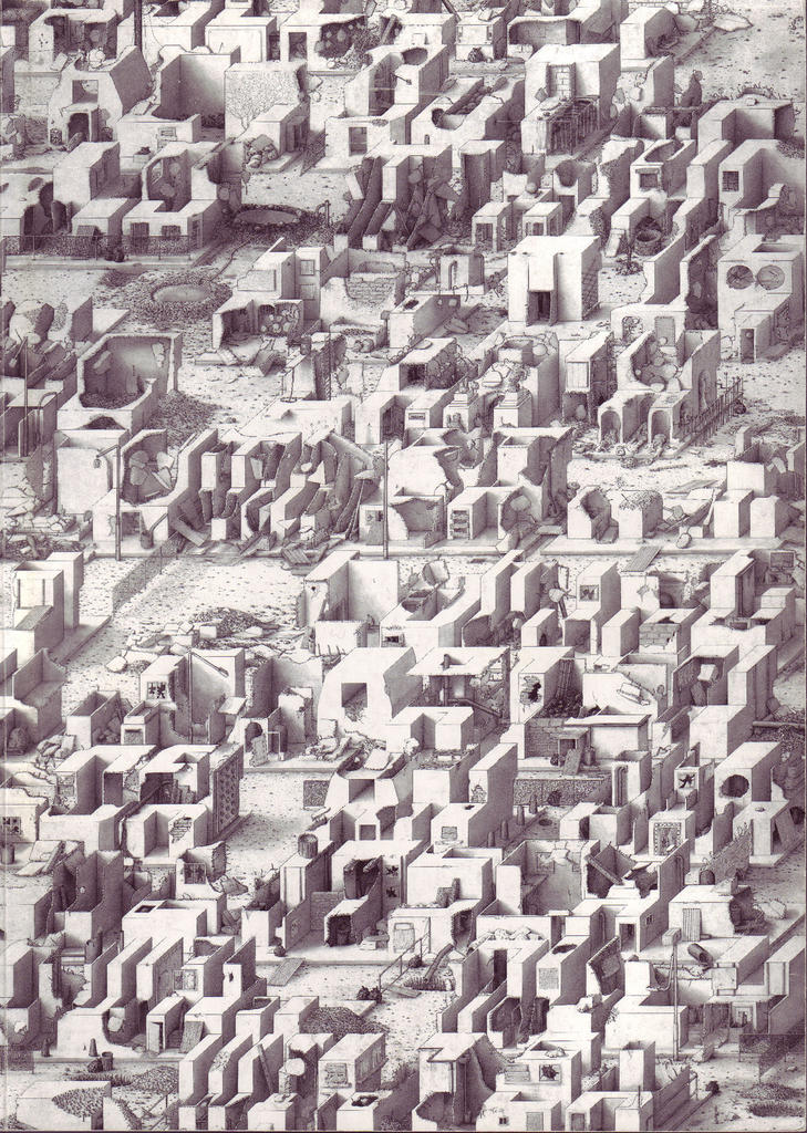
“Variously described as ‘3-D Scrabble tiles’ or ‘Lego blocks’, Noble’s pictograms name the buildings that they depict. From the hospital (Nobspital) to the cemetery (Nobsend) via the town centre (Nobson Central) or the Mall, citations from Omar Khayyam’s Rubaiyat, Gerard Winstanley’s letters to Oliver Cromwell or T.S. Eliot’s The Wasteland are camouflaged within the fields, the trees or the brickwork. Noble’s project embodies a complex infrastructure of civil planning, social policies and historical perspectives” – and it was all done with pencil. (Book available here).


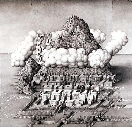
“At first,” says the BBC, “the drawings appear to be depictions of a crazy Babylonian society, with a touch of Brueghel’s Tower Of Babel and Robert Crumb’s rounded comic strips. Then you realise each building is also a 3-D letter of the alphabet spelling out hard to decipher sentences in Noble’s self-created Nobfont.”


But he wasn’t the first.
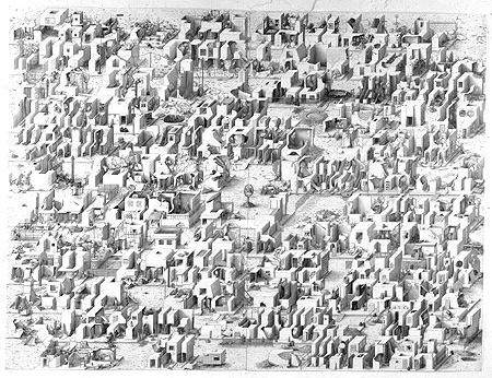
Nearly two decades earlier, in 1980, Steven Holl published his own “Alphabetical City” through Pamphlet Architecture, and it, too, consisted entirely of buildings that were actually letters, that were actually a city, that… – but the funny thing is, Holl’s drawings look absolutely, unpublishably stupid compared to Noble’s:


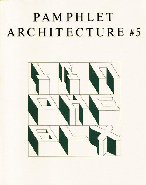
Hello? One wonders which two-minute lunch break Holl took to draw those… Or was it thirty seconds?
In any case, the creation of architectural space through a tweaking of the alphabet is not an inherently interesting proposition, but Noble’s eye-failure-inducing drawings reward repeated viewings. Just blink occasionally.
The buildings, frieze‘s Tom Morton claims, look like, “odd, wind-carved rock formations. Standing on higher ground, squinting against the sun, we’d see that they formed an eroded text.”
Here I’m reminded of the idea of “slow sculpture” from China Miéville’s novel, Iron Council:
“Huge sedimentary stones… each carefully prepared: shafts drilled precisely, caustic agents dripped in, for a slight and so-slow dissolution of rock in exact planes, so that over years of weathering, slabs would fall in layers, coming off with the rain, and at very last disclosing their long-planned shapes. Slow-sculptors never disclosed what they had prepared, and their art revealed itself only long after their deaths.”
Perhaps, in those dissolving rocks, you could plan a slow and secret alphabet…

Katrina 2: New Atlantis (on flooded cities)

New Orleans is not the only city to be faced with a future of indefinite flooding – nor is it the only city in the world below sealevel.
The entire nation of the Netherlands, for instance, provides perhaps the most famous example of urbanized land reclaimed from the Atlantic seafloor. “Polders” is the Dutch name for such rigorously flood-controlled territory, and an exhibition literally even now being held at the Rotterdam-based Netherlands Architecture Institute explores the polders’ geotechnical creation.
The polders’ “rationally organized landscape is unique, but also vulnerable,” the NAI explains. Vulnerable to overdevelopment – as well as to catastrophic flooding.
The 2005 Rotterdam International Architecture Biennale, in fact, takes nothing less than “The Flood” as its central, organizing theme – with one particular sub-focus being Water City*.


[Image: The metropolis, the flood, the boundaries of architectural design.]
In April and May, 2005, The New Yorker ran a three-part article by Elizabeth Kolbert, called “The Climate of Man,” on the subject of human-induced climate change. The third part, published on 9 May 2005, ends with a description of how “one of the Netherlands’ largest construction firms, Dura Vermeer, [has] received permission to turn a former R.V. park into a development of ‘amphibious homes'” – a floating city. (The Guardian also has an article about this.)
“The amphibious homes all look alike,” Kolbert says. Floating on the River Meuse in Maasbommel, “they resemble a row of toasters. Each one is moored to a metal pole and sits on a set of hollow concrete pontoons. Assuming that all goes according to plan, when the Meuse floods the homes will bob up and then, when the water recedes, they will gently be deposited back on land. Dura Vermeer is also working to construct buoyant roads and floating greenhouses” – the entire human race gone hydroponic.
As Dura Vermeer’s environmental director says: “There is a flood market emerging.”


[Image: A floating house, moored to the earth, in Maasbommel.]
Further afield, the year 2005 has seen major flooding in Europe, India, and Bangladesh, to name but a few sites of major hydrological catastrophe.
In Mumbai, India, *The Economist* explains, the 2005 floods “uncovered long-term failures. Not enough had been done to maintain Mumbai’s ageing infrastructure, such as storm-drains and sewers. Worse, new building had weakened the city’s defences. Large areas of protective mangrove had been razed – in one notorious example, to make way for a golf course. Developers have built on wetlands, clogging natural drainage channels. River banks have been reclaimed and become slums.”


And then there is Bangladesh. “From the air,” we read, also in The Economist (most of their articles are for subscribers only, it’s really irritating), “Bangladesh looks less like a country than one vast lake, dotted with thousands of tiny islets, clumps of trees and houses. Few boats ruffle the placid floodwaters: there is nowhere to go.” And yet “[t]he great lake of Bangladesh is in reality a network of nearly 250 rivers.”
New Orleans, Rotterdam, Bangladesh, Mumbai: 2005 will be the year of flooded infrastructure and overwhelmed cities.
And so if Atlantis sets the gold standard for civilizations lost to floods – forget Noah – then it’s interesting that Atlantis, even before Katrina occurred, was back in the news this year (though I suppose it is every year). As already explored elsewhere on BLDGBLOG, Atlantis’s island home may (or may not) be in the Straits of Gibraltar.
The real issue, however, that the infrastructural possibility of Atlantis brings to the fore – or, rather, that Katrina brings to the fore, through the hydrological destruction of New Orleans – is revealed quite clearly in the following artist’s representations of what Atlantis might have looked like:


Atlantis, city of dikes and levees, city of canals and inland seas, city of water-smart urban design and hydrological planning – it, too, was swallowed by the oceans, and destroyed.

This thread continues in Katrina 1: Levee City (on military hydrology); and Katrina 3: Two anti-hurricane projects (on landscape climatology) – both on BLDGBLOG.

Urban rock walks, or: how to podcast a landscape

If you’ve ever wondered what the streets and buildings and monuments of the UK are constructed from, a good enough place to start is the BBC’s Walks with Rocks, where psychogeography meets paleontology meets continental drift. Paleo-psycho-ontogeography, perhaps. In any case, now you can learn the geological origins of paving stones, the density, formation pressures and tectonic ancestry of the architraves on that rockin’ bldg across the street from Boots.


For instance: ‘Looking at the foyer of Berkeley Square House we can see Norwegian igneous combined with Italian freshwater spring limestones. The adjacent Citroen and Rolls Royce showrooms tempt us with Tethyan limestone full of fossils. The Tethyan region was the seaway that lay to the South of the Eurasian Continent and to the North of Australia/India/Africa during the Late Paleozoic and Early Mesozoic periods’ – from Stop 7 on the Dover Street, W1, map.
While you’re at it, my televisual posts continue with British Isles: A Natural History on BBC One: ‘The series and inserts explore how over three billion years Britain has been boiled in lava, buried under tropical swamps and swept by desert sands. They show how it was crushed by enormous glaciers, released by warm winds, forested from north to south and how the influence of human life has dramatically changed the landscape.’ You can also ask what’s beneath your feet – no, it’s not sheepshit, it’s…
Then there are these audio recordings from the BBC’s new *Coast* show, which despite suffering from a rather alarming quantity of badly-accented historical reenactors offers one model for how to podcast a landscape.
Here’s a link to the first episode of the TV show, which, in combination with the second episode, traces out the following geography:


Finally, more Atlantis b.s. in the news, but I still think it’s cool: another tsunami theory, this one about Spartel Island (now submerged) in the Straits of Gibraltar:

Kristian Birkeland’s magnetic museum: or, ‘sunspots like no one else can do better’

Kristian Birkeland, the first scientist correctly to deduce the solar-magnetic origin of the Northern Lights, at one point was obsessed with building an experimental device here on Earth that could reproduce those polar-bound auroral effects.

Though he started off only vaguely over-ambitious, a combination of hyper-caffeination in the Egyptian desert and addiction to veronal produced BLDGBLOG-worthy architectural hubris I feel should be quoted here in full. So, bearing in mind that this is a true story, as told by Lucy Jago’s book The Northern Lights:

1) Birkeland’s vacuum chamber was a ‘machine in which to recreate many phenomena of the solar system beyond the Earth. He drew up plans for a new machine unlike anything that had been made before.

…[L]ike a spacious aquarium, [the box] would provide a window into space. The box would be pumped out to create a vacuum and he would use larger globes and a more powerful cathode to produce charged particles. With so much more room he would be able to see effects, obscured in the smaller tubes, that could take his Northern Lights theory one step further – into a complete cosmogony, a theory of the origins of the universe. (…) All sorts of beautiful solar phenomena could recreated this way, such as the sun’s corona, the shining layers of the sun’s outer atmosphere, usually visible only during a total eclipse. He could reproduce sunspots that moved across the surface of the terrella [the electrical globe-mechanism inside the vacuum chamber itself]… With this extraordinary machine Birkeland was able to simulate Saturn’s rings, comet tails, and the Zodiacal Light. He even experimented with space propulsion using cathode rays. Sophisticated photographs were taken of each simulation, to be included in the next volume of Birkeland’s great work, which would discern the electromagnetic nature of the universe and his theories about the formation of the solar system.

The ensuing period of nearly hypnotised overwork is referred to later as ‘Birkeland’s immersion into the universe of his vacuum chamber’.

2) But then he got ambitious. In a letter written from a hotel in Aboukir, Egypt, where Birkeland’s addiction to caffeine and veronal was driving him insane – along with the Saharan sun – he wrote: ‘And, finally, I am going to tell you about a great idea I have had; it’s a bit premature but I think it will be realised. I am going to get some money from the state and from friends, to build a museum for the discovery of the Earth’s magnetism, magnetic storms, the nature of sunspots, of planets – their nature and creation. On a little hill I will build a dome of granite, the walls will be a metre thick, the floor will be formed of the mountain itself and the top of the dome, fourteen metres in diametre, will be a gilded copper sphere. Can you guess what the dome will cover? When I’m boasting I say to my friends here “next to God, I have the greatest vacuum chamber in the world.” I will make a vacuum chamber of 1,000 cubic metres and, every Sunday, people will have the opportunity to see a ring of Saturn ten metres in diametre, sunspots like no one else can do better, Zodiacal Light as evocative as the natural one and, finally, auroras… four metres in diametre. The same sphere will serve as Saturn, the sun, and Earth, and will be driven round by a motor.’

So, aside from conjuring up images somewhere between Frankenstein, City of Lost Children and Batman, perhaps, Birkeland’s mountaintop cosmogonic laboratory brings up the interesting possibility of modeling – even reproducing – the universe through architecture. Or, at least, through a combination of architecture and machinery (which is what architecture always was in the first place).

In any case, clue the United States Department of Energy in on this and you’ll – wait: they’ve already done it. It’s called Yucca Mountain.

Perhaps a subterranean tour of the carved radioactive vaults of Yucca Mountain will be available to someone in a few ten-thousand years. By which time Birkeland’s almost H.P. Lovecraftian visions of simulating the birth of the universe atop a granite mountaintop, beneath a copper dome, will be long forgotten.

Oh, one more thing – in fact, two more things: 1) note that cathode rays, which Birkeland used in his vacuum chambers, are also what make non-digital television possible (raising the intellectually stimulating idea that television, in and of itself, as a technical object, is a model of the cosmos); and 2) note that Birkeland says ‘next to God, I have the greatest vacuum chamber’, implying of course that the universe already is a vacuum chamber, in which case one could argue – at least rhetorically – that we are living not in the universe as such but in what is already the experimental reproduction of the universe, a universe which lies elsewhere. The universe itself, then, the universe we run tests on and live within, is just a model, a prototype even. But that’s neither here nor there…

Lunar urbanism deux

The abstract of ‘Lunar architecture and urbanism’ by Brent Sherwood reads: ‘Human civilization and architecture have defined each other for over 5000 years on Earth. Even in the novel environment of space, persistent issues of human urbanism will eclipse, within a historically short time, the technical challenges of space settlement that dominate our current view. By adding modern topics in space engineering, planetology, life support, human factors, material invention, and conservation to their already renaissance array of expertise, urban designers can responsibly apply ancient, proven standards to the exciting new opportunities afforded by space. Inescapable facts about the Moon set real boundaries within which tenable lunar urbanism and its component architecture must eventually develop.’
Sherwood was/is with the NASA Goddard Space Flight Center. An otherwise so-so paper, published originally in 1992.
If only he knew about the viab/nozzle