Gravesend is a suburb east of London, hosting on its own eastern edge something of a secondary suburb: a mysterious town on the edge of town that turns out not to be a town at all.
The barren streets and hollow buildings of this militarized non-place were designed for use as an immersive staging ground for police-training exercises, fighting staged riots, burglaries, bank robberies, and other crimes.
Facades with no buildings behind them line the empty streets; in some cases, it is only through the aerial views afforded by a service like Google Maps that this reality is made clear.
Imitation bus stops, make-believe banks, and an oddly whimsical Pizzaland—like an end-times chain restaurant from Shaun of the Dead—sustain the illusion on the ground.
Somewhat incongruously, an airplane fuselage also now rests beside a chainlink fence near the roadway, giving officers an opportunity to prepare for airplane hijackings.
There are even empty Tube carriages parked outside town for improvisatory police raids.
According to AIS, their consultant-designers kitted out the site’s “live-fire ranges with internal ballistic and anti-ricochet finishes, simulation and targetry equipment, and range sound systems,” a complete multimedia package that would soon also include HD video projectors and even “laser-based 3D virtual training environments.”
Architectural simulations embedded with high-tech, upgradeable media technology thus supply the necessary level of detail for repeating crimes, on demand, like strange social rituals.
The photos seen here were all take by designer and photographer Chris Clarke, whose Flickr set of the series, including a dozen or so further images, is worth a look.
For Clarke, the “facsimile” urbanism of this site at the end of Gravesend is actually something of “a warning—a prophecy of society’s potential to alienate itself from itself.” He suggests that these surreal scenes threaten to become indistinguishable from everyday life, our cities and streets stripped down to the civic minimum, used as nothing more than bleak stomping grounds for futuristic security forces armed with military-grade tools.
“We have estates, parks, nightclubs, tube stations,” Clarke writes, “but is the community missing from Gravesend significantly more present in our inhabited cities and towns?” His own answer remains unspoken but obvious.
Writing about this same site back in 2008, Brian Finoki of Subtopia called it a “new theater of the absurd.”
It is, he wrote, “a city standing on the planet for one purpose: to be rioted, hijacked, trashed, held hostage, sacked, and overrun by thousands of chaotic scenarios, only so that it can be reclaimed, retaken, re-propped in circuitous loops of more dazzling proto-militant exercise, stormed by a thousand coordinated boots for eternity, targeted by hundreds of synchronized crosshairs of both lethal and non-lethal weapons.”
It’s hard to resist a story where urban design is blamed for creating tornadoes. But the recent cluster of “freak mini-tornadoes” striking Istanbul offers an anomaly in search of an explanation, and the newly built outer edges of the metropolis are potentially to blame.
According to Ed Danaher at NOAA’s Center for Weather and Climate Prediction, speaking to the Hürriyet Daily News, “we know that tornadoes are exotic to Istanbul, like snow is to Florida.” That article go on to suggest, however, that these tornadoes “are possibly one result of the city’s rapid urbanization,” and that such a claim can be made based on their conversations with other meteorological researchers working at NOAA.
As their headline states bluntly, “Istanbul tornadoes [are] a ‘result of urbanization’.”
This conjures up frankly outrageous images of a city so sprawling—and so thermally ill-conceived—that huge masses of air at different temperatures are now rising into the sky to do battle, violently colliding like mythological titans above the city to generate the surreal tornadoes now ripping through the neighborhoods below.
Weather might be the future of urban design—but the rest of the news story actually includes no such quotations or any relevant evidence that would back up such a claim. They refer to climate change and its effects on regional humidity, of course, but, oddly enough, there is otherwise no attempt to back up the opening statement.
But… But… It’s so tempting to speculate. Beyond just being clickbait, this vision of suburban sprawl inadvertently churning the skies with the introduced turbulence of tornadoes, and thus destroying the landscape like some twisted instant karma of the atmosphere, is too awesome not to entertain for at least the length of a cup of coffee.
What weird old gods of weather have Istanbul’s architects accidentally awoken? As streets and buildings continue to bulge outward into the forests and hills of the region, what else might their spatial activities unleash?
[Image: Liberian security forces implement “a quarantine of the West Point slum, stepping up the government’s fight to stop the outbreak and unnerving residents.” Photo by Abbas Dulleh/AP, via Al Jazeera America].
Of Forcible Blockades and Military Isolation
A neighborhood-scale quarantine was forcibly imposed on the slums of Monrovia, Liberia, yesterday to help prevent the spread of Ebola.
Using makeshift roadblocks—consisting, for the most part, of old furniture, wooden pallets, and barbed wire, as everyday objects were transformed into the raw materials of a police blockade—authorities have forcibly isolated the densely populated neighborhood of West Point from the rest of the city.
Unsurprisingly, however, poor communication, over-aggressive law enforcement tactics, and general misinformation about the nature—even the very existence—of Ebola has led to local resistance.
Al Jazeera reports, for example, that “police in the Liberian capital have fired live rounds and tear gas to disperse a stone-throwing crowd trying to break an Ebola quarantine imposed on their neighborhood.” But they were perhaps simply trying to defend themselves against a badly communicated onslaught of police wielding batons and machine guns, and they would be doing so whether Ebola was in the picture or not.
[Image: Neigborhood-scale quarantine; photo by Abbas Dulleh/AP, via Al Jazeera America].
Ubiquitous Quarantine
But this is only one of the most recent—and one of the more extreme—examples of the spatial practice of quarantine reappearing in the news in recent weeks. At the end of July, for example, the Chinese city of Yumen was partially quarantined due to an outbreak of bubonic plague, as parts of the city were “sealed off” from the neighborhoods around them; and the ongoing Ebola outbreak has led to involuntary quarantines being implemented at nearly every spatial level, from the individual to the city to entire international regions.
In the latter case, recall that just last week a cordon sanitaire was enforced in the international border regions of Guinea, Liberia, and Sierra Leone to stop people possibly infected with Ebola from crossing the borders. As the New York Times described this action, “The Ebola outbreak in West Africa is so out of control that governments there have revived a disease-fighting tactic not used in nearly a century: the ‘cordon sanitaire,’ in which a line is drawn around the infected area and no one is allowed out.”
This spatial technique for managing the spread of microbiological life has “the potential to become brutal and inhumane,” the paper adds. “Centuries ago, in their most extreme form, everyone within the boundaries was left to die or survive, until the outbreak ended.”
[Image: Enforcing quarantine; Photo by Abbas Dulleh/AP, via Al Jazeera America].
Resisting Quarantine
Yet resistance to quarantine is nearly as ubiquitous as attempts to implement it. The very notion of involuntary quarantine is important to emphasize here: this is something that must be spatially imposed on people who have not chosen to bring this condition upon themselves.
Soldiers and police officers in riot gear blocked the roads. Even the waterfront was cordoned off, with the coast guard stopping residents from setting out in canoes. The entire neighborhood, a sprawling slum with tens of thousands of people, awoke Wednesday morning to find that it was under strict quarantine in the government’s halting fight against Ebola.
The reaction was swift and violent. Angry young men hurled rocks and stormed barbed-wire barricades, trying to break out. Soldiers repelled the surging crowd with live rounds, driving back hundreds of young men.
Involuntary quarantine can inspire this type of reaction at any scale. Consider the panic-stricken family who forcibly raided a hospital in Freetown, Sierra Leone, in order to free an Ebola-stricken relative who, they had come to believe, was being held against her will; she later died, but not before passing her infection on to others. Or consider the Nigerian nurse possibly exposed to Ebola while caring for patients who nonetheless “skipped quarantine,” either out of a desperate sense of self-preservation or due to sheer ignorance of the dangers of her actions.
“Don’t Touch The Walls!”
Somewhat incredibly, though, the deliberate breaking of quarantine can also occur not out of survivalist panic or concern for one’s own medical safety, but simply for the purpose of looting. Some of the descriptions here are jaw-dropping, with raiders actually breaking into Ebola wards to steal “property like tents, tarpaulins, buckets, hospital beds, mobile phones and shoes among other things,” literally all of which could bear traces of Ebola and thus spread the contagion elsewhere.
The New York Times had a particularly chilling example of why not to steal from Ebola wards when it ran this haunting sentence two weeks ago: “‘Don’t touch the walls!’ a Western medical technician yelled out. ‘Totally infected.'”
Yet, even in the West Point quarantine zone, misguided acts of theft are rampant: “Residents stormed through” the quarantine zone, we read, also in the New York Times, “running off with a generator and supplies like mattresses, some soaked with the blood of patients who were believed to have Ebola.”
In a situation where even the hospitals are considered to be “death traps,” where the walls themselves are “totally infected” with Ebola, the designation of involuntary and militarily enforced quarantine boundaries is taken to mean the designation of a kind of urban sacrifice zone, a place where patients can be fatally off-loaded and the disease tragically but successfully contained. From this point of view, getting out of the quarantine zone becomes a top priority.
Residents of West Point have even protested that “their community, they believed, was becoming a dumping ground for Ebola patients,” and that quarantine was simply a spatial excuse for putting victims all in one place, uninfected neighbors be damned. “In all,” we read, “residents tried to break through the barricade three times on Wednesday, Col. Prince Johnson, the army’s brigade commander, said Wednesday evening by phone. His soldiers had fired in the air, he said, but he would not comment on whether they had also fired into the crowd.”
[Image: A “quarantine house” in Pennsylvania; courtesy of the U.S. Library of Congress].
Powers of Quarantine
Who has the power to quarantine? Where does this power come from—especially in a Constitutional democracy like the United States—and where exactly are this power’s limits? Does it have any?
Nicola Twilley and I explored these questions last week for the New Yorker, looking at, among other things, the Constitutional implications of quarantine powers. As we point out in that piece, there is an ethically troubling overlap between the notion of the quarantined subject, spatially isolated often against his or her will, and the liminal figure of the “enemy combatant” who potentially never faces the prospect of a legal trial whilst being indefinitely detained.
In both cases, extrajudicial detention can occur on the ground of suspicion alone—presumed guilt or infection—rather than legal or medical certainty.
In fact, writing as a coauthor on two Congressional Research Reports from 2005, legal theorist Jennifer Elsea commented on both of these categories: of the combatant held by the state without rights or legal access to resistance, and the medical subject unable to protest his or her segregation due to being held in a state of involuntary quarantine.
As we see massive international quarantine zones enforced at gunpoint throughout West Africa, and as suspected Ebola cases pop up everywhere from Johannesburg to California, it is well worth discussing where these spatial powers come from, who controls them, and when and where quarantine has reached its limit.
The Return of Quarantine
Indeed, as Twilley and I suggested back in 2010 during the “Landscapes of Quarantine” design studio and exhibition at New York’s Storefront for Art and Architecture, quarantine is a decidedly pre-modern spatial practice that is nonetheless experiencing a contemporary comeback.
Confronted with widespread antibiotic resistance and increased global air travel that can bring diseases like Ebola to every global metropolis in a matter of hours, quarantine is part of “a 14th-century toolbox” that ironically looks perfectly at home in the 21st century.
[Image: Quarantine station, Pennsylvania; courtesy of the U.S. Library of Congress].
Given all these examples of resistance, confusion, and the violence often necessary to impose spatial isolation on people only suspected of bearing a disease, we suggest in the New Yorker essay that quarantine becomes something of a spatial fiction, always and permanently on the verge of collapse. Its premise is a fantasy; the imaginary boundaries it seeks to defend are legally loose and physically porous.
Nonetheless, for all its apparent instability, quarantine offers a necessary fiction of separation and control at a time when the boundaries between health and contagion have become so vertiginous and blurred.
(Note: Parts of this post were co-written with Nicola Twilley).
For thousands of years, animal bodies have been used as living 3D printers—or sentient printheads, we might say—but the range of possible material outputs is set to change quite radically. In fact, bioengineering is rapidly making this idea—that spiders, silkworms, and honeybees, to name just a few, are already 3D printers—more than just a poetic metaphor.
Those creatures are organic examples of depositional manufacturing, and they have been domesticated and used throughout human history for specific creative ends, whether it’s to produce something as mundane as honey or silk, or something far more outlandish, including automotive plastics, military armaments, and even concrete, as we’ll see below.
Animal Printheads
Researchers in Singapore discovered several years ago, for example, that silkworms fed a chemically peculiar diet could produce colored silk, readymade for use in textiles, as if they are actually biological ink cartridges; and other examples—in which animal bodies have been temporarily tweaked or even specifically bred to produce new, economically useful materials on a semi-industrial scale—are not hard to come by.
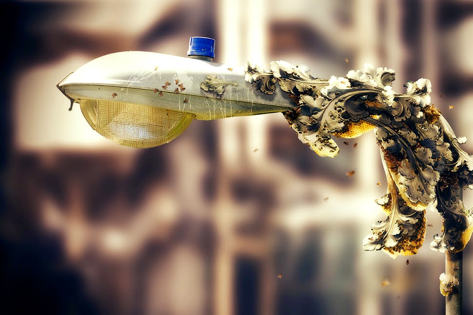
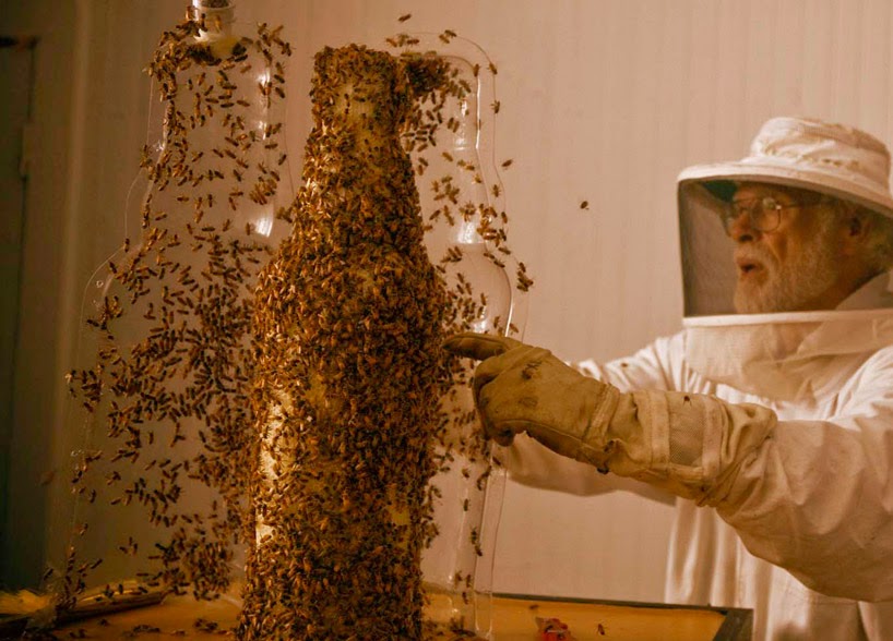
As it happens, for example, using bees as 3D printers is quickly becoming something of an accepted artistic process and its deep incorporation into advanced manufacturing processes will not be far behind.
Perhaps the most widely seen recent exploration of the animal-as-3D-printer concept was done last year for, of all things, a publicity stunt by Dewar’s, in which the company “3D printed” a bottle of Dewar’s using nothing but specially shaped and cultivated beehives.
These pictures tell the story clearly enough: using a large glass bottle as a mold in which the bees could create new hives, the process then ended with the removal of the glass and the revealing of a complete, bottle-shaped, “3D-printed” hive.
Or take the Silk Pavilion, another recent project you’ve undoubtedly already seen, in which researchers at MIT, led by architect Neri Oxman, 3D-printed a room-sized dome using carefully guided silkworms as living printheads.
The Silk Pavilion was an architectural experiment in which the body of the silkworm, guided along a series of very specific paths, was “deployed as a biological printer in the creation of a secondary structure.”
The primary structure, meanwhile—the pattern used by the silkworms as a kind of depositional substrate—was nothing more than a continuous thread wrapped around a metal scaffold like a labyrinth, seen in the image below.
It was at this point in the process that a “swarm of 6,500 silkworms was positioned at the bottom rim of the scaffold spinning flat non-woven silk patches as they locally reinforced the gaps across CNC-deposited silk fibers.” In other words, they infested the labyrinth and laid down architecture with their passing.
What both of these examples demonstrate—despite the fact that one is a somewhat tongue-in-cheek media ploy by an alcohol company—is that animal bodies can, in fact, be guided, disciplined, or otherwise regulated to produce large-scale structures, from consumer objects to whole buildings.
After all, the very origins of architecture were a collaboration with animal bodies, and experiments like these only update those earliest constructions.
In both cases, however, the animals are simply depositing, or “printing,” what they would normally (that is, naturally, in the absence of human augmentation) produce: silk and honey. Things get substantially more interesting, on the other hand, when we look at more exotic biological materials.
Bee Plastic
For half a decade or more, materials scientist Debbie Chachra at New England’s Olin College of Engineering has been researching what’s known as “bee plastic”: a cellophane-like biopolymer produced by a species native to New England, called Colletes inaequalis.
These bees secrete tiny, cocoon-like structures in the soil—one such structure can be seen in the photo, below—using a special gland unique to its species. The resulting, non-fossil-fuel-based natural polyester not only resists biodegradation, it also survives the temperate extremes of New England, from the region’s sweltering summers to its subzero winter storms.
[Image: Courtesy of Deb Chachra].
More intriguingly, however, the cellophane-like bee plastic “doesn’t come from petroleum,” Chachra explained to me for a 2011 end-of-year article in Wired UK. “The bees are pretty much just eating pollen and producing this plastic,” she continued, “and we’re trying to understand how they do it.”
Bee plastic, Chachra justifiably speculates, could perhaps someday be used to manufacture everything from office supplies to car bumpers, acting as an oil-free alternative to the plastics we use today. In the process, it could perhaps even kickstart a homegrown bio-industry for New England, where the species already thrives, wherein the very idea of a factory needs to be fundamentally reimagined.
The most exciting architectural possibilities here come less from the bees themselves and more from the elaborate structures that would be required to house their activities; imagine a brand new BMW factory somewhere in the suburbs of Boston populated only by plastic-producing bees, and you get some sense of where industrial manufacturing might go in an alternate future. Not unlike Dewar’s bee-printed bottle, then, augmented cousins of Chachra’s plastic-producing bees could thus 3D-print whole car bodies, kitchen counters, architectural parts, and other everyday products.
But even this, of course, is a vision of animal-based manufacturing that relies on the already-existent excretions of living creatures. Could we—temporarily putting aside the ethical implications of this, simply to discuss the material possibilities—perhaps genetically modify bees, silkworms, spiders, and so on to produce substantially more robust biopolymers, something not just strong enough to resist biodegrading but that could be produced and used on an industrial scale?
Recall, for example, that the U.S Army, working with a Canadian firm called Nexia Biotechnologies, was successful in its attempt to genetically engineer a goat that would produce spider-silk proteins in its milk. Incredibly, those “Biosteel goats,” as they were later known, were eventually housed in old ammunition bunkers on a New York State military base, as if they were living bioweapons that needed to be held in quarantine.
[Image: Biosteel goats summed-up in one simple equation (via)].
The ultimate goal of producing these goats was to generate an unbreakable super-fiber that could be used in battle gear, including “lightweight body armor made of artificial spider silk,” and other military armaments; but others have speculated that entire bridges or other pieces of urban infrastructure could someday be woven by goats.
These possibilities become even more strange and promising when we move to materials like concrete.
Concrete Honey
As part of an ongoing collaborative project, NYC-based designer John Becker and I have been looking at the possibility of using bees that have been genetically modified to print concrete. We could call them architectural printheads.
Initially inspired by a somewhat willful misreading of a project published under the title “Bees Make Concrete Honey,” John and I began to imagine and illustrate a series of science-fictional scenarios in which a new urban bee species, called Apis caementicium—or cement bees—could be deployed throughout the city as a low-cost way to repair statues and fix architectural ornament, even to produce whole, free-standing structures, such as cathedrals.
In a process not unlike that used for the Dewar’s bottle, above, the bees would be given an initial form to work within. Then, buzzing away inside this mold or cast, and additively depositing the ingredients for bio-concrete on the walls, frames, or structures they’ve been attached to, the bees could 3D-print new architectural forms into existence.
This includes, for example, the iconic stone lions found outside the New York Public Library; they’ve been damaged by exposure and human contact, but can now be fixed from within by concrete bees. Think this as a kind of organic caulking.
Yet tidy plots such as these invariably spin out of control and things don’t quite go as planned.
Feral Printers
Predictably, these concrete bees eventually escape: first just a few here and there, but then an upstart colony takes hold elsewhere in the city. They breed, speciate, and expand.
Within a few years, as the bees reproduce and thrive, and as their increasingly far-flung colonies grow, people become aware of the scale of the problem: rogue 3D-printing bees have begun to infest the region.
They print where they shouldn’t print and, without the direction of their carefully made formwork and molds, what they produce often makes no sense.
They print on signs and phone poles; they take over parks and gardens where they print strange forms on flowers, sealing orchids and roses in masonry shells. Bizarre gardens of hardened geometry form on windowsills and ledges, deep in urban forests and along railways and roads.
Tiny fragments of concrete can soon be seen atop plants and door frames, beneath cars and on chain-link fences, coiling up and consuming the sides of structures where they were never meant to be, like kudzu; and, of course, strange bee bodies are found now and again, these little concrete-laden corpses lying in the deep grass of backyards, on parking lots and rooftops.
Their fallen bodies, augmented and extraordinary, thus dot the very city they’ve also beautified and improved—this place where they once printed church steeples and apartment ornament, where they fixed cracked statues, sidewalks, and walls.
Of course, other, more adventurous or simply disoriented bees make their way further, hitching inadvertent rides in the holds of planes and cargo ships, mistakenly joining other hives then shipped around the world.
The bees are soon found in Europe, China, and—for reasons never quite clear to materials scientists—throughout India, where, as in the sample image below, they can be seen adding unnecessary ornamentation to temples in Rajasthan. Swarming and uncountable, they busily speck the outside of the building with bulbous and tumid additions no architect would ever have planned.
As the bees speciate yet further, and their concrete itself begins to mutate—in some cases, so hard it can only be removed by the toughest drills and demolition equipment, other times more like a slow-drying sandstone incapable of achieving any structure at all—this experiment in animal printheads, these living 3D printers producing architecture and industrial objects, comes to end.
A Bee Amidst The Machines
Most designers learn from the—in retrospect—obvious mistakes that led to these feral printers, returning to more easily controlled inorganic factories and industrial processes. But, even then, on quiet spring days, a tiny buzzing sound can occasionally be heard beneath someone’s front porch, out in the suburban gardens somewhere, deep inside National Parks, and even inside huge machines, where whole automobile assembly lines come shuddering to a halt.
There, within the gears, just doing what it’s used to doing—what we made it do—a tiny family of 3D-printing bees has taken root, leaving errant clumps of concrete wherever they alight.
(Thanks to John Becker for the fun. An earlier version of this post was previously published on Gizmodo).
The technical systems by which autonomous, self-driving vehicles will safely navigate city streets are usually presented as some combination of real-time scanning and detailed mnemonic map or virtual reference model created for that vehicle.
As Alexis Madrigal has written for The Atlantic, autonomous vehicles are, in essence, always driving within a virtual world—like Freudian machines, they are forever unable to venture outside a sphere of their own projections:
The key to Google’s success has been that these cars aren’t forced to process an entire scene from scratch. Instead, their teams travel and map each road that the car will travel. And these are not any old maps. They are not even the rich, road-logic-filled maps of consumer-grade Google Maps.
They’re probably best thought of as ultra-precise digitizations of the physical world, all the way down to tiny details like the position and height of every single curb. A normal digital map would show a road intersection; these maps would have a precision measured in inches.
The vehicle can thus respond to the city insofar as its own spatial expectations are never sufficiently contradicted by the evidence at hand: if the city, as scanned by the vehicle’s array of sensors and instruments, corresponds to the vehicle’s own internal expectations, then it can make the next rational decision (to turn a corner, stop at an intersection, wait for a passing train, etc.).
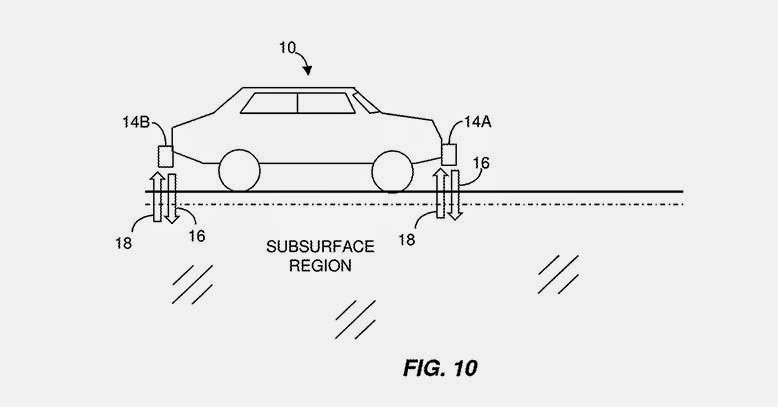
However, I was very interested to see that an MIT research team led by Byron Stanley had applied for a patent last autumn that would allow autonomous vehicles to guide themselves using ground-penetrating radar. It is the subterranean realm that they would thus be peering into, in addition to the plein air universe of curb heights and Yield signs, reading the underworld for its own peculiar landmarks.
How would it work? Imagine, the MIT team suggests, that your autonomous vehicle is either in a landscape blanketed in snow. It is volumetrically deformed by all that extra mass and thus robbed not only of accurate points of measurement but also of any, if not all, computer-recognizable landmarks. Or, he adds, imagine that you have passed into a “GPS-denied area.”
In either case, you and your self-driving vehicle run the very real risk of falling off the map altogether, stuck in a machine that cannot find its way forward and, for all intents and purposes, can no longer even tell road from landscape.
Stanley’s group has thus come up with the interesting suggestion that you could simply give autonomous vehicles the ability to see through the earth’s surface and scan for recognizable systems of pipework or other urban infrastructure down below. Your vehicle could then just follow those systems through the obscuring layers of rain, snow, or even tumbleweed to its eventual destination.
These would be cars attuned to the “subsurface region,” as the patent describes it, falling somewhere between urban archaeology and speleo-cartography.
In fact, with only the slightest tweaking of this technology and you could easily imagine a scenario in which your vehicle would more or less seek out and follow archaeological features in the ground. Picture something like an enormous basement in Rome or central London—or perhaps a strange variation on the city built entirely for autonomous vehicles at the University of Michigan. It is a vast expanse of concrete built—with great controversy—over an ancient site of incredible archaeological richness.
Climbing into a small autonomous vehicle, however, and avidly referring to the interactive menu presented on a touchscreen dashboard, you feel the vehicle begin to move, inching forward into the empty room. The trick is that it is navigating according to the remnant outlines of lost foundations and buried structures hidden in the ground around you, like a boat passing over shipwrecks hidden in the still but murky water.
The vehicle shifts and turns, hovers and circles back again, outlining where buildings once stood. It is acting out a kind of invisible architecture of the city, where its routes are not roads at all but the floor plans of old buildings and, rather than streets or parking lots, you circulate through and pause within forgotten rooms buried in the ground somewhere below.
In this “subsurface region” that only your vehicle’s radar eyes can see, your car finds navigational clarity, calmly poking along the secret forms of the city.
[Image: A perspectival representation of the “ideal city,” artist unknown].
There’s an interesting throwaway line in The Verge‘s write-up of yesterday’s Amazon phone launch, where blogger David Pierce remarks that the much-hyped public unveiling of Amazon’s so-called Fire Phone was “oddly focused on art history and perspective.”
As another post at the site points out, “Amazon CEO Jeff Bezos likened it to the move from flat artwork to artwork with geometric perspective which began in the 14th century.”
These are passing comments, sure, and, from Amazon’s side, it’s more marketing hype than anything like rigorous phenomenological theorizing. Yet there’s something strangely compelling in the idea that a seemingly gratuitous new consumer product—just another smartphone—might actually owe its allegiance to a different technical lineage, one less connected to the telecommunications industry and more from the world of architectural representation.
[Image: Jeff Bezos as perspectival historian. Courtesy of The Verge].
It would be a smartphone that takes us back to, say, Albrecht Dürer and his gridded drawing machines, making the Fire Phone a kind of perspectival object that deserves a place, however weird, in architectural history. Erwin Panofksy, we might say, would have used a Fire Phone—or at least he would have written a blog post about it.
In this context, the amazing image of billionaire Jeff Bezos standing on stage, giving a kind of off-the-cuff history of perspectival rendering surely belongs in future works of architectural history. Smiling and schoolteacher-like, Bezos gestures in front of an infinite grid ghosted-in over this seminal work of urban scenography, in one moment aiming to fit his product within a very particular, highly Western tradition of representing the built environment.
The launch of the Fire Phone did indeed give perspectival representation its due, showing how a three-dimensionally or relationally accurate perception of geometric space can change quite dramatically with only a small move of the viewer’s own head.
The phone’s “dynamic perspective,” engineered to correct this, seems a little rickety at best, but it is meant as way to account for otherwise inconsequential movements of the viewer through the landscape, whether it’s a crowded city street or the vast interiors of a hotel. To do so requires an almost comical amount of technical hand-waving. From The Verge:
The key to making dynamic perspective work is knowing exactly where the user’s head is at all times, in real time, many times per second, Bezos said. It’s something that the company has been working on for four years, and [the] best way to do it is with computer vision, he went on to note. The single, standard front-facing camera wasn’t sufficient because its field of view was too narrow—so Amazon included four additional cameras with a much wider field of view to continuously capture a user’s head. At the end of the day, it features four specialized front-facing cameras in addition to the standard front-facing camera found near the earpiece, two of which can be used in case the other cameras were covered; it uses the best two at any given time. Lastly, Amazon included infrared lights in each camera to allow the phone to work in the dark.
Five hundred years ago, we’d instead be reading about some fabulous new system of mirrors, lens, prisms, and strings, all tied back to or operated by way of complexly engineered works of geared furniture. Unfolding tables and adjustable chairs, with operable flaps and windows.
[Image: One of several perspectival objects—contraptions for producing spatially accurate drawings—by Albrecht Dürer].
These precursors of the Fire Phone, after seemingly endless acts of fine-tuning, would then, and only then, allow their users to see the scene before them with three-dimensional accuracy.
Now, replace those prisms and mirrors with multiple forward-facing cameras and infrared sensors, and market the resulting object to billions of potential users in front of gridded scenes of Western urbanism, and you’ve got the strange moment that happened yesterday, where a smartphone aimed to collapse all of Western art history into a single technical artifact, a perspectival object many of us will soon be carrying in our bags and pockets.
[Image: Another “ideal city,” artist unknown].
More interestingly, though, with its odd focus “on art history and perspective,” Amazon’s event raises the question of how electronic mediation of the built environment might be affecting how our cities are designed in the first place—how we see buildings, streets, and cities through the dynamic lens of automatic perspective correction and other visual algorithms.
Put another way, is there a type of architecture—Classical, Romanesque—particularly well-suited for perspectival objects like the Fire Phone, and, conversely, are there types of built space that throw these devices off altogether? Further, could artificial environments that exceed the rendering capacity of smartphones and other digital cameras be deliberately designed—and, if so, what would they “look like” to those sensors and objects?
Recall that, at one point in his demonstration, Bezos explained how Amazon’s new interface “uses different layers to hide and show information on the map like Yelp reviews,” effectively tagging works of architecture with digital metadata in a kind of Augmented Reality Lite.
But what this suggests, together with Bezos’s use of “ideal city” imagery, is that smartphone urbanism will have its own peculiar stylistic needs. Perhaps, if visually defined, that will mean that phones will require cities to be gridded and legible, with clear spatial differentiation between buildings and objects in order to function most accurately—in order to line up with the clouds of virtual tags we will soon be placing all over the structures around us. Perhaps, if more GPS-defined, that will mean overlapping buildings and spaces are just fine, but they nonetheless must allow unblocked access to satellite signals above so that things don’t get confused down at street level—a kind of celestial perspectivism where, from the phone’s point of view, the roof is the new facade, the actual “front” of the building through which vital navigational signals must travel.
Either way, the possibility that there is a particular type of space, or a particular type of urbanism, most suited to the perspectival needs of new smartphones is totally fascinating. Perhaps in retrospect, this photograph of Jeff Bezos, grinning at the world in front of a gigantic image of Western perspective, will become a canonical architectural image of where digital objects and urban design intersect.
The last few weeks have been extremely busy, and there’s been no real time to post here on BLDGBLOG; so many interesting stories have come and gone, so many ideas to discuss and write about here, but I’ve primarily been working full-throttle in my new role as Editor-in-Chief of Gizmodo, where I’ve joined a team tasked with continuing the site’s transition away from pure tech news and gadget reviews to include the worlds of architecture, urbanism, and design. Any sufficiently large technology is indistinguishable from a landscape, we might say; any sufficiently ubiquitous machine indistinguishable from a city.
[Image: Inside a wind tunnel, courtesy of NASA, via Gizmodo].
In any case, I will be very busy for the foreseeable future in my new role—but we’ve published some really fantastic features there over the past few weeks alone, and I thought I’d throw up a quick post to give BLDGBLOG readers a taste of what’s to come. Here’s a solid list for a long day’s perusal:
—Gizmodo was part of the first media tour since the 1980s of Hart Island, the largest mass grave site in the United States, run by the Department of Corrections on the outer maritime edge of New York City.
—”Capture houses” are entire decoy apartments and homes—furnished, lit, and run like actual residences—that, in reality, are elaborate traps for capturing burglars.
Enjoy! Meanwhile, I’ll see you on the internet, here, there, and elsewhere, though the frequency of posting here will now be closer to just 2 or 3 times a month.
Military strategist David Kilcullen was in New York City earlier this week to talk about the future of urban warfare at the World Policy Institute. I tagged along to learn more about “future conflicts and future cities,” as Kilcullen describes it, and to see what really happens when urban environments fail: when cities fall apart or disintegrate into ungovernable canyons of semi-derelict buildings ruled by cartels, terrorist groups, and paramilitary gangs.
Kilcullen’s overall thesis is a compelling one: remote desert battlegrounds and impenetrable mountain tribal areas are not, in fact, where we will encounter the violence of tomorrow. For Kilcullen—indeed, for many military theorists writing today—the war in Afghanistan was not the new normal, but a kind of geographic fluke, an anomaly in the otherwise clear trend for conflicts of an increasingly urban nature.

The title of Kilcullen’s book—Out of the Mountains—suggests this. War is coming down from the wild edges of the world, driving back toward our lights and buildings from the unstructured void of the desert, and arriving, at full force, in the hearts of our cities, in our markets and streets. The recent siege in Nairobi and the Mumbai attacks, to name only two examples that came up in Kilcullen’s discussion, are evidence of the urbanization of violence and war.
But if cities—particularly in the world’s coastal, developing regions—are a hotbed for future aggression, as Kilcullen and other military theorists suggest, then is it possible that we could somehow design away this growing problem? Kilcullen, a former soldier with the Australian military, said repeatedly that there is no military solution here. If we want to war-proof our cities, so to speak, then we’ll need more than guns and ammo.

So violence is coming down out of the mountains, Kilcullen explained, and it is taking root in the spaces of everyday life, in cities and suburbs where both infrastructure and governance have failed. This is the “future environment” or operational theater that military planners both fear and rigorously prepare for, one populated by feral cities—one of my favorite phrases of all time, coined in 2003 by Richard Norton—dystopian urban wastelands ruled over by loose constellations of gangs.
However, these same military planners are not the ones who should be most closely focused on the darkening horizon: rather, Kilcullen emphasized, we need to push civilian designers and professionals into thinking about “urban environments that are dramatically under stress,” as he phrased it during his talk.

Kilcullen’s own professional role—a member of the executive team at Caerus Associates, a “strategy and design firm” working with architects and urban planners from its base in Washington D.C.—is, in and of itself, a vote of confidence in a non-military solution. “We help clients understand and thrive in complex, conflict-afflicted, and disaster-affected environments,” they write.
 [Image: David Kilcullen, from Out of the Mountains].
An articulate and precise speaker—his somewhat menacing message, of overpopulated cities trapped in death spirals, tempered only slightly by a soothing and intact Aussie accent—Kilcullen outlined where the cities of the world are going, how violence is following them, and where this conflict comes from in the first place. There were multiple take-aways.
Crime is Warfare on Another Scale
There has been “a blurring of the distinction between crime and warfare” in urban environments, he pointed out. Armed gangs and paramilitary terrorist groups are blurring together. Look no further than cartel violence in northern Mexico and you can see that a sufficiently organized criminal is no different than a warlord.
We might say that a large enough crime spree is indistinguishable from an insurgency—a revolution against order in the city.
Feral Suburbs
It is not always correct to call these environments “cities,” on the other hand, nor to assume that all of the violence is, in fact, truly “urban”—rather, much of these conflicts are bred in what Kilcullen described as “diffuse” environments, or informal settlements on the “peri-urban” edge of the metropolis.
So, while we might say feral cities or cities gone wild, the problem is actually the violence of the diffuse and the decentered—the disorganized and the anti-urban—unexpectedly popping up in the city core.
Urban Embassies
We need to move beyond the nation-state and to think, instead, at the level of cities. Kilcullen here made the observation that, rather than having an India desk or an Egypt desk, for example, whether at a major newspaper or in the U.S. State Department, we should think much more specifically: assigning groups of analysts to particular conurbations for their unique urban needs. A Mumbai desk, a Nairobi desk.
As but one example, Kilcullen mentioned the NYPD has established what are, in effect, “New York embassies,” in Kilcullen’s words, in cities abroad. These overseas branches of the New York Police Department form a global circuit of city-to-city intelligence gathering operations; these are important sources of coordination and local expertise, both more subtle and far cheaper than a military operation.
Even beyond this, Kilcullen emphasized the growing political importance of cities, as administrative units, and the urgency with which we need to understand their functioning. His analysis also suggests a new and surprising geopolitical actor in the world: the mayor. The mayor of a mega-city like New York can be far more important on the international stage than even the leader of a nation-state, and the city itself—whether it’s Lagos or Mexico City—can often punch far above the weight of the nation-state it’s found within.
Failure From Above
During the Q&A, Kilcullen briefly mentioned the work of Crisis Mappers, who have developed tools for visually analyzing urban form using satellite photos. According to Kilcullen, they are able to do this with an astonishing degree of accuracy, diagnosing what parts of cities seem most prone to failure. Whether this is due to empty lots and abandoned buildings or to infrastructural isolation from the rest of the city, the factors that determine “ferality” in the built environment is a kind of aerial application of the Broken Windows theory.
The implication—conceptually fascinating, but by no means convincing, at least for me—was that we could, in theory, develop a visual algorithm for identifying environments tending toward failure, and thus find a way to intervene before things truly fall apart. Teams of architects with their own dedicated satellites could thus scan the cities of the world from above, algorithmically identifying urban regions prone to collapse, then intervening with a neighborhood redesign. It sounds great—it’s very high-tech and would make a great comic book—but it seems highly unlikely as the true way forward.

In the end, then, it was this larger notion of “intervening” that became the elephant in the room. How is it to be done? What is intervention in the first place? How do we de-stress an urban landscape through design?
Again, this is something not achieved by blowing things up with cruise missiles, Kilcullen made clear, but by reorganizing the city, strengthening local lines of communication and governance, and treating urban planning as an alternative to war.
In any case, Kilcullen himself is a better advocate of his ideas, and his book is a better place to start, delving into all of the above points in greater detail (and including further examples, such a series of drug raids in Kingston, Jamaica, and their spatial legacy in British colonialism).
(This post originally appeared on Gizmodo; reproduced with permission.)
[Image: Screenshot of our own SimCity—called, for reasons that made sense at the time, We Are The Champignons—after three hours of game play].
(This interview was originally published on Venue).
In the nearly quarter-century since designer Will Wright launched the iconic urban planning computer game, SimCity, not only has the world’s population become majoritatively urban for the first time in human history, but interest in cities and their design has gone mainstream.
In March 2013, the first new iteration of SimCity in a decade was launched, amidst a flurry of critical praise mingled with fan disappointment at Electronic Arts’ “always-online” digital rights management policy and repeated server failures.
A few weeks before the launch, Venue—BLDGBLOG’s ongoing collaboration with Edible Geography‘s Nicola Twilley, supported by the Nevada Museum of Art‘s Center for Art + Environment—had the opportunity to play the new SimCity at its Manhattan premiere, during which time we feverishly laid out curving roads and parks, drilled for oil while installing a token wind turbine, and tried to ignore our city’s residents’—known as Sims—complaints as their homes burned before we could afford to build a fire station.
We emerged three hours later, blinking and dazed, into the gleaming white and purple lights of Times Square, and were immediately struck by the intensity of abstraction required to translate such a complex, dynamic environment into a coherent game structure, and the assumptions and values embedded in that translation.
Fortunately, the game’s lead designer, Stone Librande, was happy to talk with us further about his research and decision-making process, as well as some of the ways in which real-world players have already surprised him. We spoke to him both in person and by telephone, and our conversation appears below.
• • •
Nicola Twilley: I thought I’d start by asking what sorts of sources you used to get ideas for SimCity, whether it be reading books, interviewing urban experts, or visiting different cities?
Stone Librande: From working on SimCity games in the past, we already have a library here with a lot of city planning books. Those were really good as a reference, but I found, personally, that the thing I was most attracted to was using Google Earth and Google Street View to go anywhere in the world and look down on real cities. I found it to be an extremely powerful way to understand the differences between cities and small towns in different regions.
Google has a tool in there that you can use to measure out how big things are. When I first started out, I used that a lot to investigate different cities. I’d bring up San Francisco and measure the parks and the streets, and then I’d go to my home town and measure it, to figure out how it differed and so on. My inspiration wasn’t really drawn from urban planning books; it was more from deconstructing the existing world.
Then I also really got into Netflix streaming documentaries. There is just so much good stuff there, and Netflix is good at suggesting things. That opened up a whole series of documentaries that I would watch almost every night after dinner. There were videos on water problems, oil problems, the food industry, manufacturing, sewage systems, and on and on—all sorts of things. Those covered a lot of different territory and were really enlightening to me.
Geoff Manaugh: While you were making those measurements of different real-world cities, did you discover any surprising patterns or spatial relationships?
Librande: Yes, definitely. I think the biggest one was the parking lots. When I started measuring out our local grocery store, which I don’t think of as being that big, I was blown away by how much more space was parking lot rather than actual store. That was kind of a problem, because we were originally just going to model real cities, but we quickly realized there were way too many parking lots in the real world and that our game was going to be really boring if it was proportional in terms of parking lots.
Manaugh: You would be making SimParkingLot, rather than SimCity.
Librande: [laughs] Exactly. So what we do in the game is that we just imagine they are underground. We do have parking lots in the game, and we do try to scale them—so, if you have a little grocery store, we’ll put six or seven parking spots on the side, and, if you have a big convention center or a big pro stadium, they’ll have what seem like really big lots—but they’re nowhere near what a real grocery store or pro stadium would have. We had to do the best we could do and still make the game look attractive.
[Image: Using the zoning tool for the city designed by We Are the Champignons].
Twilley: I’d love to hear more about the design process and how you went about testing different iterations. Did you storyboard narratives for possible cities and urban forms that you might want to include in the game?
Librande: The way the game is set up, it’s kind of infinite. What I mean by that is that you could play it so many different ways that it’s basically impossible to storyboard or have a defined set of narratives for how the player will play it.
[Images: Stone Librande’s storyboards for “Green City” and “Mining City” at the start of play].
Instead, what I did was that I came up with two extreme cases—around the office we call them “Berkeley” and “Pittsburgh,” or “Green City” and “Dirty City.” We said, if you are the kind of player who wants to make utopia—a city with wind power, solar power, lots of education and culture, and everything’s beautiful and green and low density—then this would be the path you would take in our game.
But then we made a parallel path for a really greedy player who just wants to make as much money as possible, and is just exploiting or even torturing their Sims. In that scenario, you’re not educating them; you’re just using them as slave labor to make money for your city. You put coal power plants in, you put dumps everywhere, and you don’t care about their health.
[Image: Stone Librande’s storyboard for “Green City” at mid-game].
I made a series of panels, showing those two cities from beginning to late stage, where everything falls apart. Then, later on, when we got to multiplayer, I joined those two diagrams together and said, “If both of these cities start working together, then they can actually solve each other’s problems.”
The idea was to set them up like bookends—these are the extremes of our game. A real player will do a thousand things that fall somewhere in between those extremes and create all sorts of weird combinations. We can’t predict all of that.
Basically, we figured that if we set the bookends, then we would at least understand the boundaries of what kind of art we need to build, and what kind of game play experiences we need to design for.
[Image: Stone Librande’s storyboard for “Mining City” at mid-game].
Twilley: In going through that process, did you discover things that you needed to change to make game play more gripping for either the dirty city or the clean city?
Librande: It was pretty straightforward to look at Pittsburgh, the dirty city, and understand why it was going to fail, but you have to try to understand why the clean one might fail, as well. If you have one city—one path—that always fails, and one that always succeeds, in a video game, that’s really bad design. Each path has to have its own unique problems.
What happened was that we just started to look at the two diagrams side-by-side, and we knew all the systems we wanted to support in our game—things like power, utilities, wealth levels, population numbers, and all that kind of stuff—and we basically divided them up.
We literally said: “Let’s put all of this on this side over in Pittsburgh and the rest of it over onto Berkeley.” That’s why, at the very end, when they join together, they are able to solve each other’s problems because, between the two of them, they have all the problems but they also have all the answers.
[Image: Stone Librande’s storyboard for the “Green City” and “Mining City” end-game symbiosis].
Twilley: One thing that struck me, after playing, was that you do incorporate a lot of different and complex systems in the game, both physical ones like water, and more abstract ones, like the economy. But—and this seems particularly surprising, given that one of your bookend cities was nicknamed Berkeley—the food system doesn’t come into the game at all. Why not?
Librande: Food isn’t in the game, but it’s not that we didn’t think about it—it just became a scoping issue. The early design actually did call for agriculture and food systems, but, as part of the natural process of creating a video game, or any situation where you have deadlines and budgets that you have to meet, we had to make the decision that it was going to be one of the things that the Sims take care of on their own, and that the Mayor—that is, the player—has nothing to do with it.
I watched some amazing food system documentaries, though, so it was really kind of sad to not include any of that in the game.
[Image: Data layer showing ore deposits].
[Image: Data layer showing happiness levels. In SimCity, happiness is increased by wealth, good road connections, and public safety, and decreased by traffic jams and pollution].
Manaugh: Now that the game is out in the world, and because of the central, online hosting of all the games being played right now, I have to imagine that you are building up an incredible archive of all the decisions that different players have made and all the different kind of cities that people have built. I’m curious as to what you might be able to make or do with that kind of information. Are you mining it to see what kinds of mistakes people routinely make, or what sorts of urban forms are most popular? If so, is the audience for that information only in-house, for developing future versions of SimCity, or could you imagine sharing it with urban planners or real-life Mayors to offer an insight into popular urbanism?
Librande: It’s an interesting question. It’s hard to answer easily, though, because there are so many different ways players can play the game. The game was designed to cover as many different play patterns as we could think of, because our goal was to try to entertain as many of the different player demographics as we could.
So, there are what we call “hardcore players.” Primarily, they want to compete, so we give them leader boards and we give them incentives to show they are “better” than somebody else. We might say: “There’s a competition to have the most people in your city.” And they are just going to do whatever it takes to cram as many people into a city as possible, to show that they can win. Or there might be a competition to get the most rich people in your city, which requires a different strategy than just having the most people. It’s hard to keep rich people in a city.
Each of those leader boards, and each of those challenges, will start to skew those hardcore people to play in different ways. We are putting the carrot out there and saying: “Hey, play this way and see how well you can do.” So, in that case, we are kind of tainting the data, because we are giving them a particular direction to go in and a particular goal.
On the other end of the spectrum, there are the “creative players” who are not trying to win—they are trying to tell a story. They are just trying to create something beautiful. For instance, when my wife plays, she wants lots of schools and parks and she’s not at all concerned with trying to make the most money or have the most people. She just wants to build that idealized little town that she thinks would be the perfect place to live.
[Image: A regional view of a SimCity game, showing different cities and their painfully small footprints].
So, getting back to your question, because player types cover such a big spectrum, it’s really hard for us to look at the raw data and pull out things like: “This is the kind of place that people want to live in.” That said, we do have a lot of data and we can look at it and see things, like how many people put down a park and how many people put in a tram system. We can measure those things in the aggregate, but I don’t think they would say much about real city planning.
Twilley: Building on that idea of different sorts of players and ways of playing, are there a variety of ways of “winning” at SimCity? Have you personally built cities that you would define as particularly successful within the game, and, if so, what made them “winners”?
Librande: For sure, there is no way to win at SimCity other then what you decide to put into the game. If you come in with a certain goal in mind—perhaps, say, that you want a high approval rating and everyone should be happy all the time— then you would play very differently than if you went in wanting to make a million dollars or have a city with a million people in it.
As far as my personal city planning goes, it has varied. I’ve played the game so much, because early on I just had to play every system at least once to understand it. I tried to build a power city, a casino city, a mining city—I tried to build one of everything.
Now that I’m done with that phase, and I’m just playing for fun at home, I’ve learned that I enjoy mid-density cities much more then high-density cities. To me, high-density cities are just a nightmare to run and operate. I don’t want to be the mayor of New York; I want to be the mayor of a small town. The job is a lot easier!
Basically, I build in such a way as to not make skyscrapers. At the most, I might have just one or two because they look cool—but that’s it.
[Image: Screenshot from SimCity 4].
Manaugh: I’m curious how you dealt with previous versions of SimCity, and whether there was any anxiety about following that legacy or changing things. What are the major innovations or changes in this version of the game, and what kinds of things did you think were too iconic to get rid of?
Librande: First of all, when we started the project, and there were just a few people on the team, we all agreed that we didn’t want this game to be called SimCity 5. We just wanted to call it SimCity, because if we had a 5 on the box, everybody would think it had to be SimCity 4 with more stuff thrown in. That had the potential to be quite alienating, because SimCity 4 was already too complicated for a lot of people. That was the feedback we had gotten.
Once we made that title decision, it was very liberating—we felt like, “OK, now we can reimagine what the brand might be and how cities are built, almost from scratch.”
Technically, the big difference is the “GlassBox” engine that we have, in which all the agents promote a bottom-up simulation. All the previous SimCity games were literally built on spreadsheets where you would type a number into a grid cell, and then it propagated out into adjacent grid cells, and the whole city was a formula.
SimCity 4 was literally prototyped in Excel. There were no graphics—it was just a bunch of numbers—but you could type a code that represented a particular type of building and the formulae built into the spreadsheet would then decide how much power it had and how many people would work there. It just statically calculated the city as if it were a bunch of snapshots.
[Image: A fire breaks out in the city designed by We Are The Champignons].
Because our SimCity—the new SimCity—is really about getting these agents to move around, it’s much more about flows. Things have to be in motion. I can’t look at anybody’s city as a screenshot and tell you what’s going on; I have to see it live and moving before I can fully understand if your roads are OK, if your power is flowing, if your water is flowing, if your sewage is getting dumped out, if your garbage is getting picked up, and so on. All that stuff depends on trucks actually getting to the garbage cans, for example, and there’s no way to tell that through a snapshot.
[Image: Sims queue for the bus at dawn].
Once we made that decision—to go with an agent-driven simulation and make it work from the bottom up—then all the design has to work around that. The largest part of the design work was to say: “Now that we know agents are going to run this, how do schools work with those agents? How do fire and police systems work with these agents? How do time systems work?” All the previous editions of SimCity never had to deal with that question—they could just make a little table of crimes per capita and run those equations.
Manaugh: When you turned things over to the agents, did that have any kind of spatial effect on game play that you weren’t expecting?
Librande: It had an effect, but it was one that we were expecting. Because everything has to be in motion, we had to have good calculations about how distance and time are tied together. We had to do a lot of measurements about how long it would really take for one guy to walk from one side of the city to the other, in real time, and then what that should be in game time—including how fast the cars needed to move in relationship to the people walking in order to make it look right, compared to how fast would they really be moving, both in game time and real time. We had all these issues where the cars would be moving at eighty miles an hour in real time, but they looked really slow in the game, or where the people were walking way, way too fast, but actually they were only walking at two miles an hour.
We knew this would happen, but we just had to tweak the real-life metrics so that the motion and flow look real in the game. We worked with the animators, and followed our intuition, and tried to mimic the motion and flow of crowds.
[Image: We Are The Champignons’ industrial zone, carefully positioned downwind of the residential areas].
In the end, it’s not one hundred percent based on real-life metrics; it just has to look like real life, and that’s true throughout the game. For example, if we made the airport runways actual size, they would cover up the entire city. Those are the kinds of things where we just had to make a compromise and hope that it looked good.
Twilley: Actually, one of the questions we wanted to ask was about time in the game. I found it quite intriguing that there are different speeds that you can choose to play at, but then there’s also a distinct sense of the phases of building a city and how many days and nights have to pass for certain changes to occur. Did you do any research into how fast cities change and even how the pace of city life is different in different places?
Librande: We found an amazing article about walking speeds in different cities. That was something I found really interesting. In cities like New York, people walk faster, and in medium-sized or small towns, they walk a lot slower. At one point, we had Sims walking faster as the city gets bigger, but we didn’t take it that far in the final version.
I know what you are talking about, though: in the game, bigger cities feel a lot busier and faster moving. But there’s nothing really built into the game to do that; it’s just the cumulative effect of more moving parts, I guess. In kind of a counter-intuitive way, when you start getting big traffic jams, it feels like a bigger, busier city even though nothing is moving—it’s just to do with the way we imagine rush-hour gridlock as being a characteristic of a really big city.
The fact that there’s even a real rush hour shows how important timing is for an agent-based game. We spent a lot of time trying to make the game clock tick, to pull you forward into the experience. In previous SimCities, the day/night cycle was just a graphical effect—you could actually turn it off if you didn’t like it, and it had no effect on the simulation. In our game, there is a rush hour in the morning and one at night, there are school hours, and there are shopping hours. Factories are open twenty-four hours a day, but stores close down at night, so different agents are all working on different schedules.
The result is that you end up getting really interesting cycles—these flows of Sims build up at certain times and then the buses and streets are empty and then they build back up again. There’s something really hypnotic about that when you play the game. I find myself not doing anything but just watching in this mesmerized state—almost hypnotized—where I just want to watch people drive and move around in these flows. At that point, you’re not looking at any one person; you’re looking at the aggregate of them all. It’s like watching waves flow back and forth like on a beach.
For me, that’s one of the most compelling aspects of our game. The timing just pulls you forward. We hear this all the time—people will say, “I sat down to play, and three hours had passed, and I thought, wait, how did that happen?” Part of that is the flow that comes from focusing, but another part of it is the success of our game in pulling you into its time frame and away from the real-world time frame of your desk.
Twilley: Has anything about the way people play or respond to the game surprised you? Is there anything that you already want to change?
Librande: One thing that amazed me is that, even with the issues at the launch, we had the equivalent of nine hundred man-years put into SimCity in less than a week.
Most of the stuff that people are doing, we had hoped or predicted would happen. For example, I anticipated a lot of the story-telling and a lot of the creativity—people making movies in the cities, and so on—and we’re already seeing that. YouTube is already filled with how-to videos and people putting up all these filters, like film noir cities, and it’s just really beautiful.
[Video: SimCity player Calvin Chan’s film noir montage of his city at night].
The thing I didn’t predict was that, in the first week, two StarCraft players—that’s a very fast-paced space action game, in case you’re not familiar with it, and it’s fairly common for hardcore players to stream their StarCraft battles out to a big audience—decided to have a live-streamed SimCity battle against each other. They were in a race to be the first to a population of 100,000; they live-streamed their game; and there were twenty thousand people in the chat room, cheering them on and typing in advice—things like “No, don’t build there!” and “ What are you doing—why are you putting down street cars?” and “Come on, dude, turn your oil up!” It was like that, nonstop, for three hours. It was like a spectator sport, with twenty thousand people cheering their favorite on, and, basically, backseat city planning. That really took me by surprise.
I’m not sure where we are going to go with that, though, because we’re not really an eSport, but it seems like the game has the ability to pull that out of people. I started to try to analyze what’s going on there, and it seems that if you watch people play StarCraft and you don’t know a lot about it, your response is going to be something like, “I don’t know what I’m looking at; I don’t know if I should be cheering now; and I don’t know if what I just saw was exciting or not.”
But, if you watch someone build a city, you just know. I mean, I don’t have to teach you that putting a garbage dump next to people’s houses is going to piss them off or that you need to dump sewage somewhere. I think the reason that the audience got so into it is that everyone intuitively knows the rules of the game when it comes to cities.
• • •
For more Venue interviews, on human interactions with the built, natural, and virtual environments, check out the Venue website in full.
ScanLAB Projects, a reliably interesting and enthusiastic design-research duo formed by Bartlett graduates Matthew Shaw and William Trossell, explores, in their words, “the potential of large scale terrestrial laser scanning as a tool for design, visualization and fabrication. We use a range of state-of-the-art 3D scanning technologies to capture buildings, objects and spaces.”
As it happens, they mean this quite literally, as they aim to “capture” and then illicitly reproduce, using multi-axis milling machines, architectural details scanned around London. These are what they call “detail thefts… arguably cloning the original architect’s intellectual property.”
You can read an earlier write-up of their many projects—from “stealth objects” to scanner-jamming architectural ornament installed on an urban scale—here on BLDGBLOG (as well as in the forthcoming Landscape Futures book).
What I find so consistently interesting in their work, though, is that, over the past few years, they’ve been expanding the representational range of the laser scanner, using it to document highly ephemeral, even ethereal, spatial events.
Whether scanning mist and humidity or traveling north to the Arctic to shoot lasers at pressure ridges and melting ice floes, their work is almost a kind of documentary holography: not a film, not a photograph, not a 3D model, but also not simply a point-cloud, their work operates almost narratively as they capture objects or places in the process of becoming something else, blurred by passing fog or pulled apart by unseen ocean currents. You could write a screenplay for scanners.
For a more recent project, one that indicates a growing environmental or ecological emphasis in their work, the duo found themselves in the presence of heavy forestry equipment, a haunting and behemoth machine busy uprooting, de-branching, and stacking trees, converting a living forest to mere timber. The satiny black background makes it all that much more dreamlike, as if occurring in secret at 2am.
Cast in black and white and seeming to gleam in the laser light, the machine is both dinosaur-like and ghostly, implying the total gutting of the forest around it as the orderly bar code of the trees is disrupted by this artificial clearing.
In all cases, the images are much more evocative when viewed at a larger size (see captions for direct links), which you can also find on the ScanLAB Projects website.
Finally, if all this interests you, consider signing up for a 10-day workshop with ScanLAB Projects up in Ottawa, Canada, from 5-13 July 2013, focusing on “post-industrial landscapes.” Here’s the course description:
Set within the context of a post-industrial era, we find ourselves venturing through the Canadian wilderness of Gatineau Park, walking in the footsteps of industrial alchemist Thomas “Carbide” Willson. Within this natural blossom lie the ruins of his former empire, the decaying heart of industrialization and manufacturing in a factory that never fully materialized.
The course will explore 3D devices that can scan the unnatural post-industrial landscape in an attempt to fuse the accidental qualities of discovery—such as Willson’s trial and error of calcium carbide—with the mathematical precision of laser-scanned environments. Students will form their own architectural “carbide,” a fusion of scans and digital modeling to generate a landscape that materialies from Willson’s place of decay into a new architectural ground.
More information, including registration, is available here.
[Image: Machines slide beneath the streets, via Crossrail].
The Crossrail tunnels in London—for now, Europe’s largest construction project, scheduled to finish in 2018—continue to take shape, created in a “tunneling marathon under the streets of London” that aims to add 26 new miles of underground track for commuter rail traffic.
It’s London as Laocoön, wrapped in tunnel-boring machines, mechanical snakes that coil through their own hollow nests beneath the city.
[Image: Looking down through shafts into the subcity, via Crossrail].
What interested me the most in all this, however, was simply that fact that the first tunneling machine put to work in this round of excavation is called Phyllis—
—named after Phyllis Pearsall, widely (but incorrectly?) mythologized as the founder of the legendary A-Z book of London street maps.
There’s something very Psychogeography Lite™ in this, weaving your city together from below with a giant machine-needle named after the woman who (supposedly) first walked the streets of the capital, assembling her book of maps, as if the only logical direction to go, once you’ve mapped the surface of your city, is down, passing through those surfaces to explore larger and darker volumes of urban space.

 [Image: From Gravesend—The Death of Community by Chris Clarke].
 [Image: From Gravesend—The Death of Community by Chris Clarke].
 [Image: From Gravesend—The Death of Community by Chris Clarke].
 [Image: From Gravesend—The Death of Community by Chris Clarke].
 [Image: From Gravesend—The Death of Community by Chris Clarke].
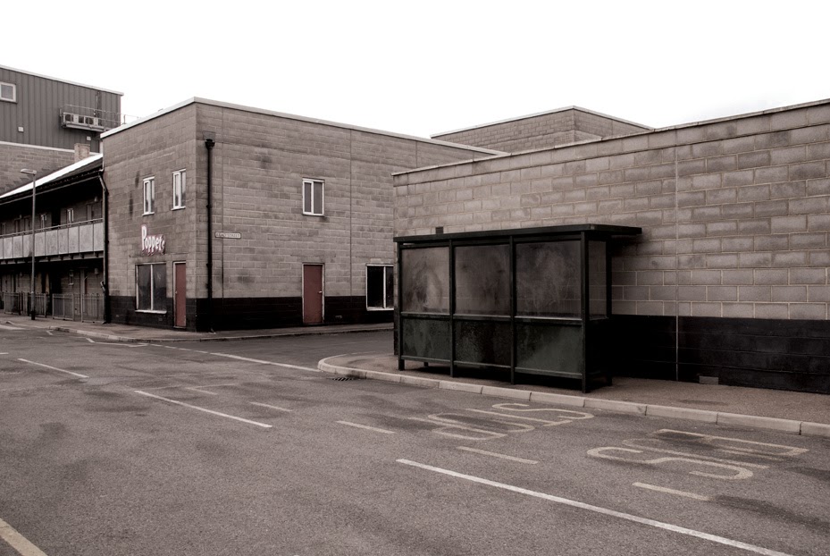 [Image: From Gravesend—The Death of Community by Chris Clarke].
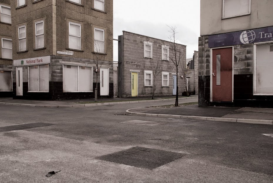
 [Images: From Gravesend—The Death of Community by Chris Clarke].
 [Image: From Gravesend—The Death of Community by Chris Clarke].
 [Image: From a
 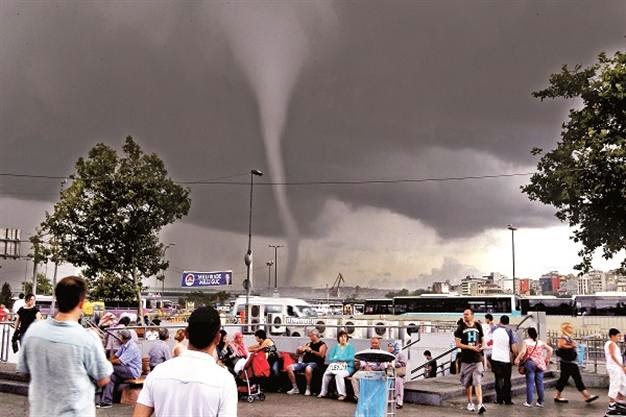 [Image: Photographer uncredited; via the
 [Image: Liberian security forces implement “a quarantine of the West Point slum, stepping up the government’s fight to stop the outbreak and unnerving residents.” Photo by Abbas Dulleh/AP, via
 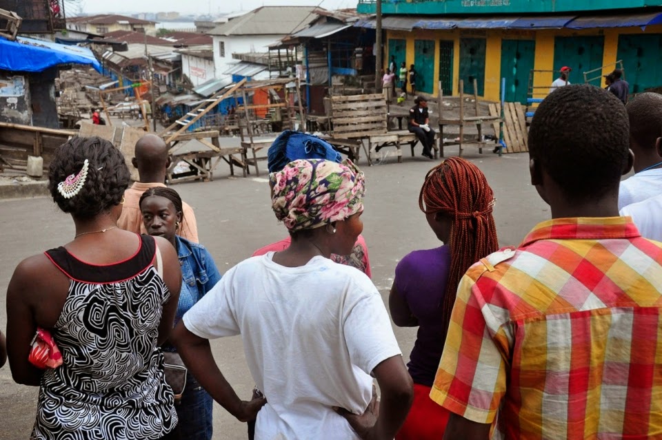 [Image: Neigborhood-scale quarantine; photo by Abbas Dulleh/AP, via
  [Image: Enforcing quarantine; Photo by Abbas Dulleh/AP, via
 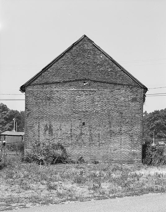 [Image: A “quarantine house” in Pennsylvania; courtesy of the U.S.
  [Image: Quarantine station, Pennsylvania; courtesy of the U.S.
 [Image: By
 [Images: Courtesy of Dewar’s, via

 [Images: Courtesy of Dewar’s, via
  [Image: Courtesy of
  [Image: Courtesy of
  [Image: Courtesy of
 [Images: Courtesy of
  [Image: Courtesy of Deb Chachra].
 [Image: Biosteel goats summed-up in one simple equation (
 [Image: By
  [Image: By
  [Image: By
  [Image: By
  [Image: By
  [Image: By
 [Image: From a patent filed by MIT, courtesy
 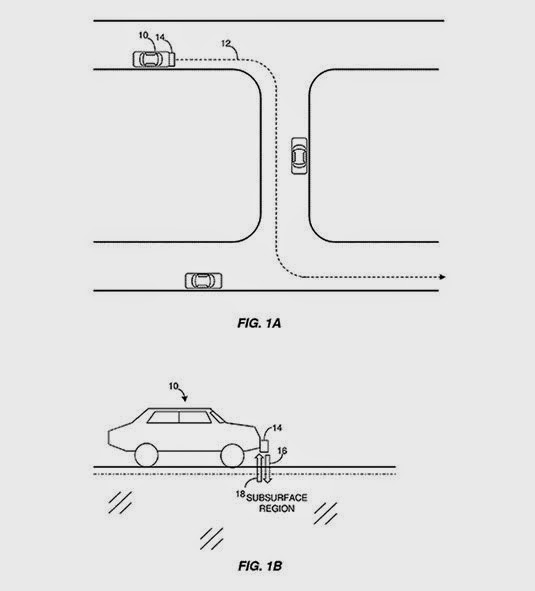 [Image: From a patent filed by MIT, courtesy
  [Image: From a patent filed by MIT, courtesy
 [Image: A perspectival representation of the “ideal city,” artist unknown].
 [Image: Jeff Bezos as perspectival historian. Courtesy of
  [Image: Courtesy of
  [Image: One of several perspectival objects—contraptions for producing spatially accurate drawings—by Albrecht Dürer].
 [Image: Another “ideal city,” artist unknown].
 [Image: Collage by
  [Image: Inside a wind tunnel, courtesy of NASA, via
 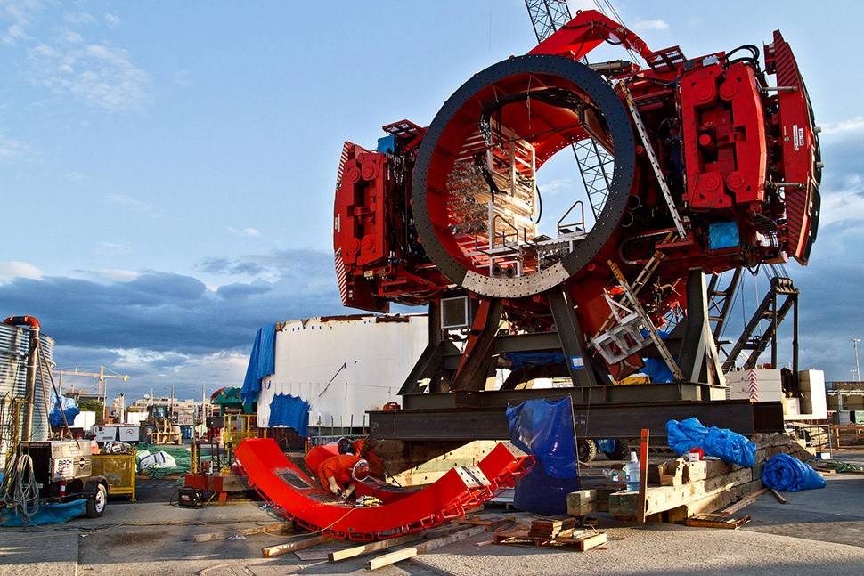 [Image: Bertha, a tunneling
  [Image: David Kilcullen, from
  [Image: David Kilcullen, from
 [Image: Screenshot of our own SimCity—called, for reasons that made sense at the time, We Are The Champignons—after three hours of game play].
 [Image: A


 [Image: Using the zoning tool for the city designed by We Are the Champignons].
 [Images: Stone Librande’s storyboards for “Green City” and “Mining City” at the start of play].
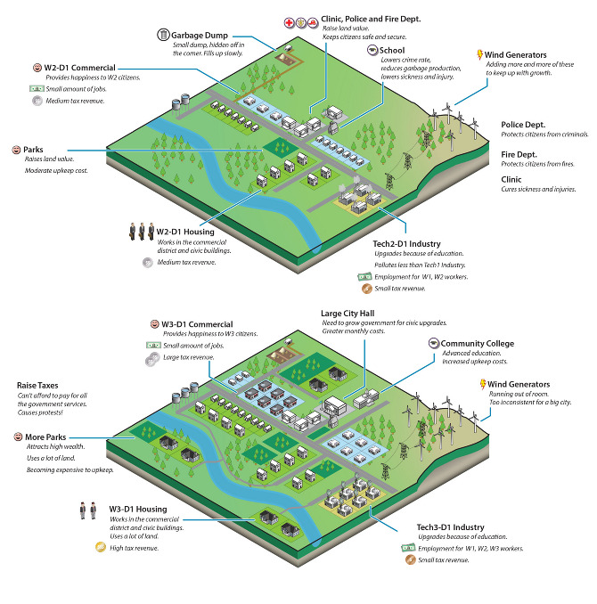 [Image: Stone Librande’s storyboard for “Green City” at mid-game].
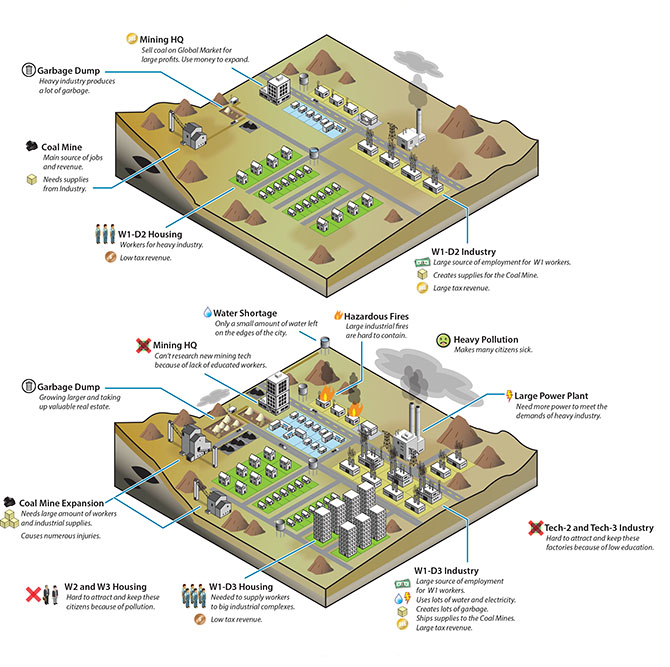 [Image: Stone Librande’s storyboard for “Mining City” at mid-game].
 [Image: Stone Librande’s storyboard for the “Green City” and “Mining City” end-game symbiosis].
 [Image: Data layer showing ore deposits].
 [Image: Data layer showing happiness levels. In SimCity, happiness is increased by wealth, good road connections, and public safety, and decreased by traffic jams and pollution].
 [Image: A regional view of a SimCity game, showing different cities and their painfully small footprints].
 [Image: Screenshot from SimCity 4].
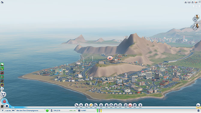 [Image: A fire breaks out in the city designed by We Are The Champignons].
 [Image: Sims queue for the bus at dawn].
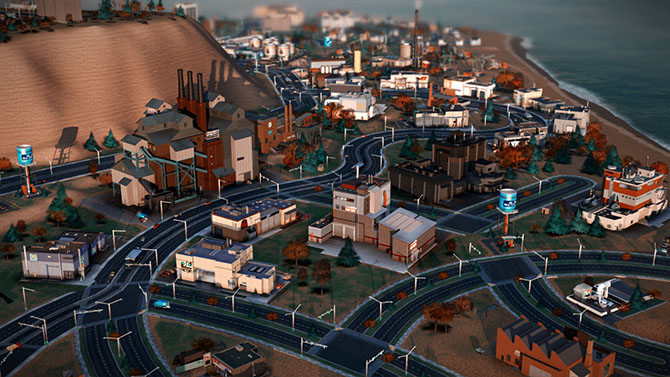 [Image: We Are The Champignons’ industrial zone, carefully positioned downwind of the residential areas].


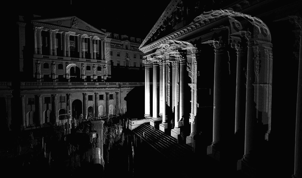 [Image: A “
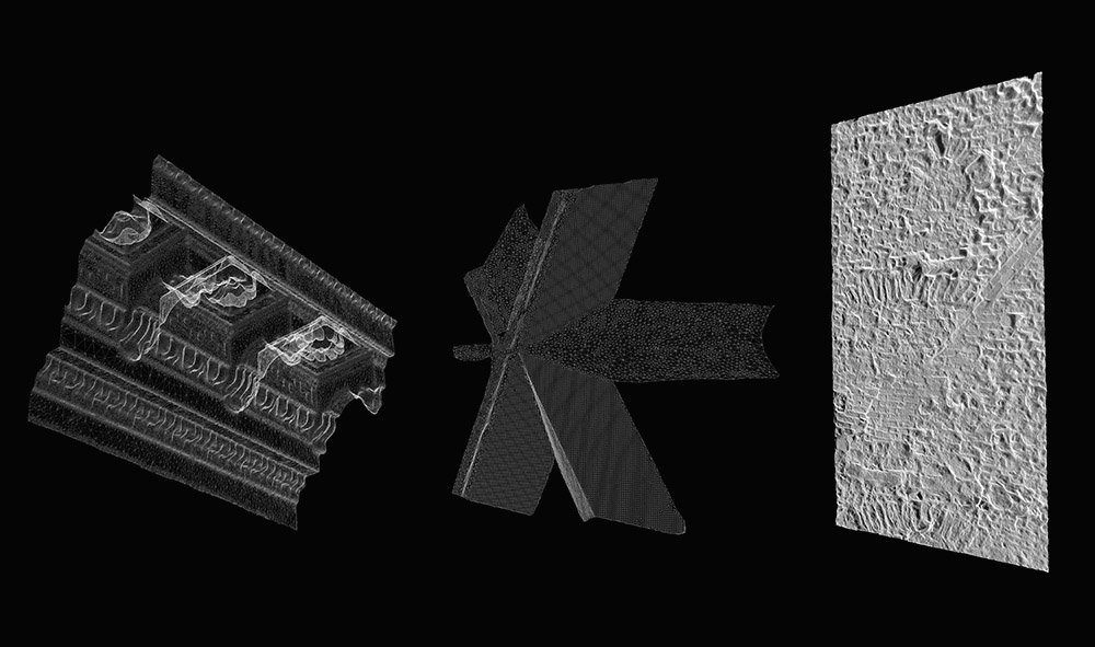 [Image: A “
 [Images: From the “
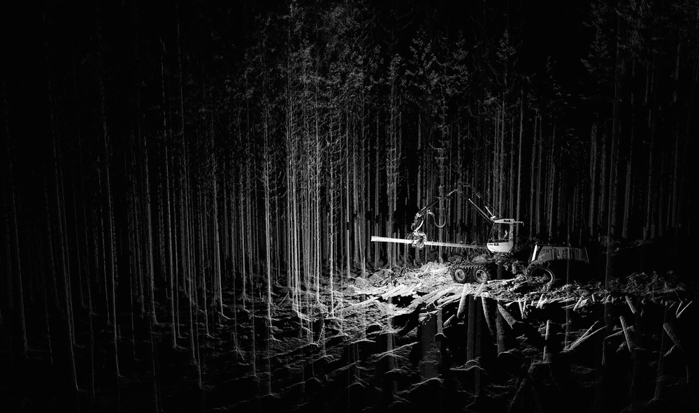 [Image:
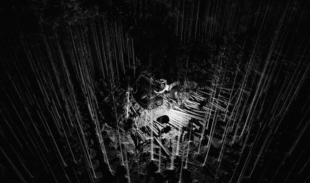
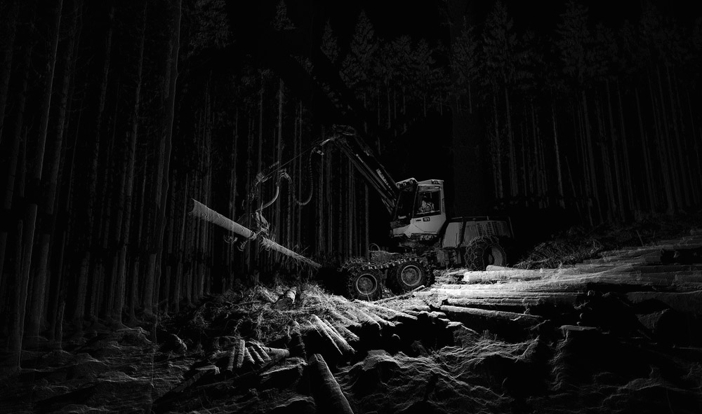
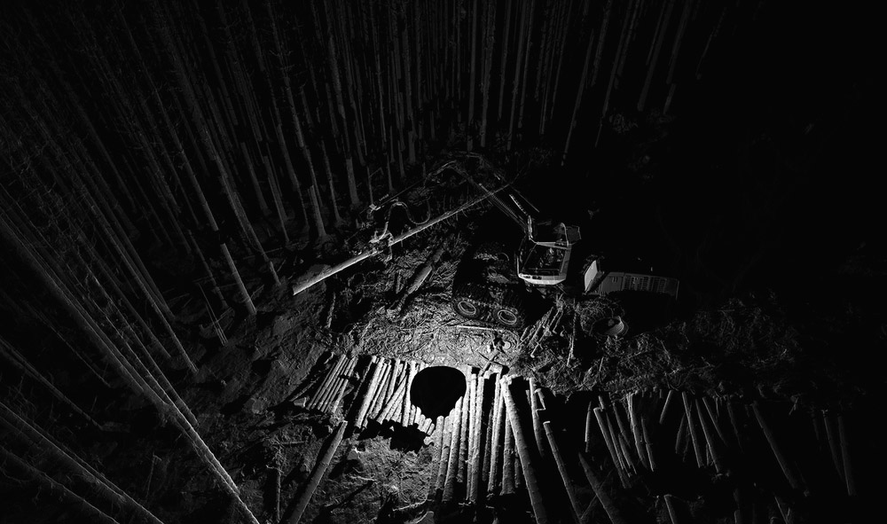
 [Image: Scans of a
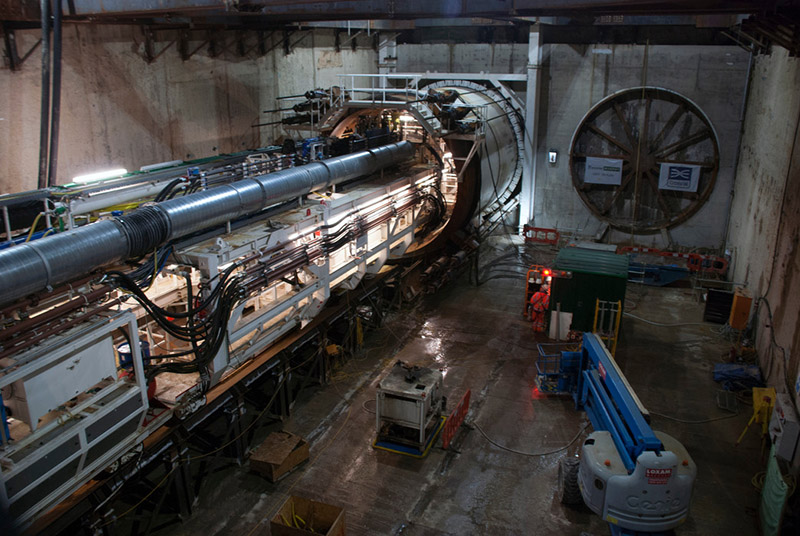 [Image: Machines slide beneath the streets, via
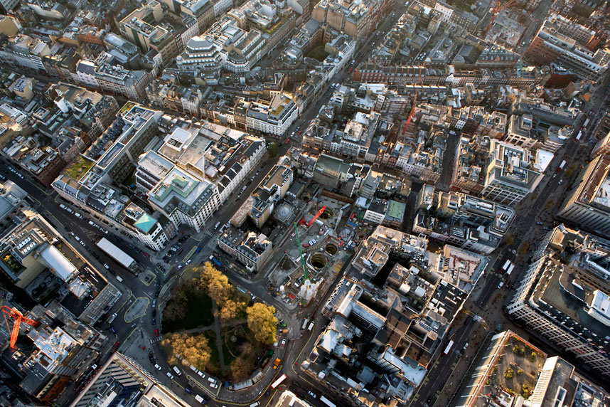

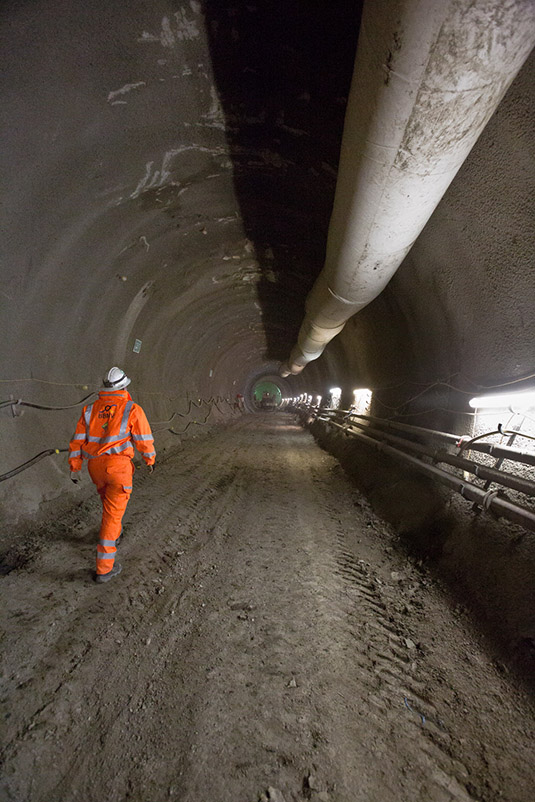 [Image: Looking down through shafts into the subcity, via
  [Image: Phyllis, via
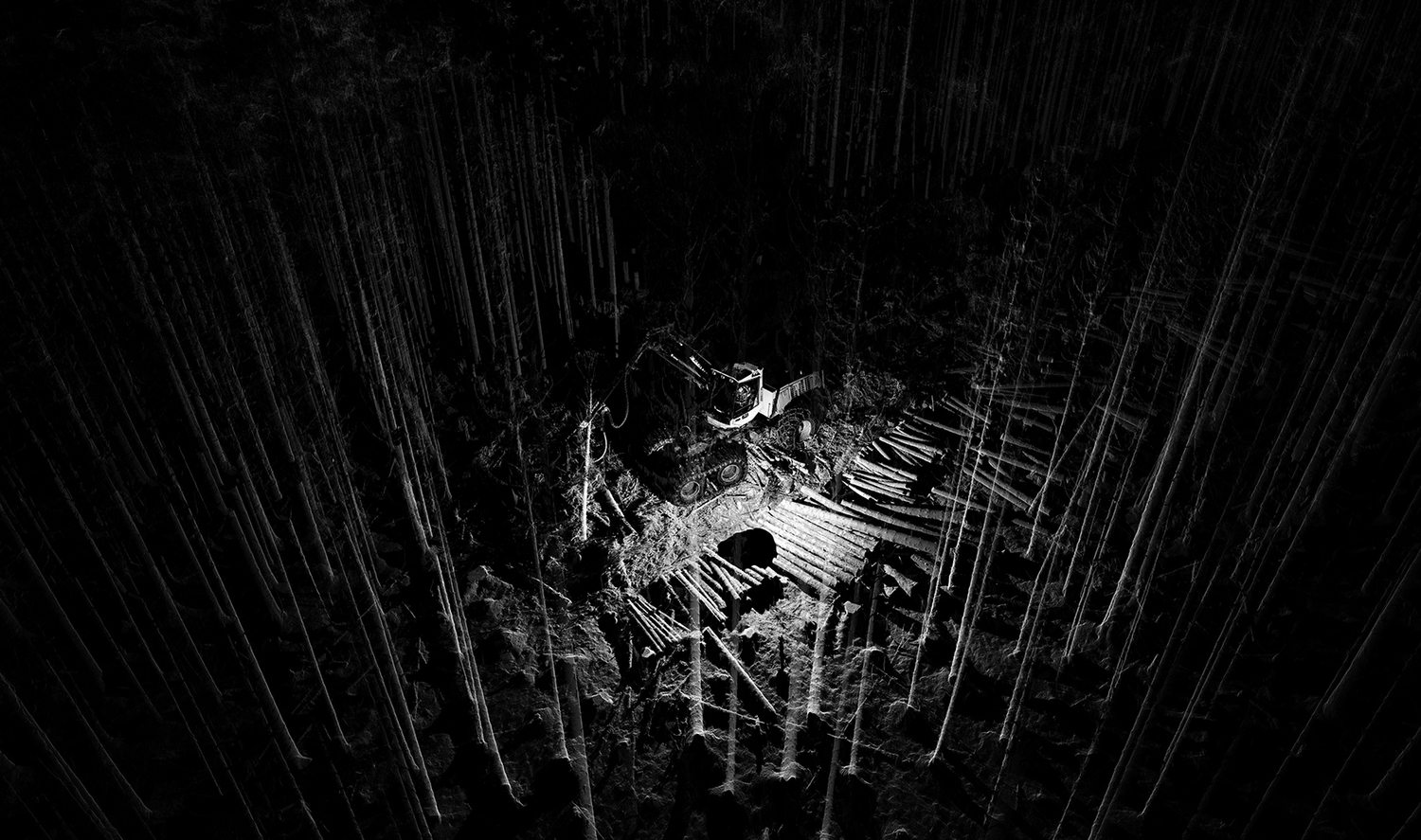
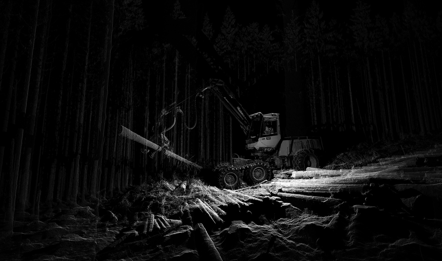
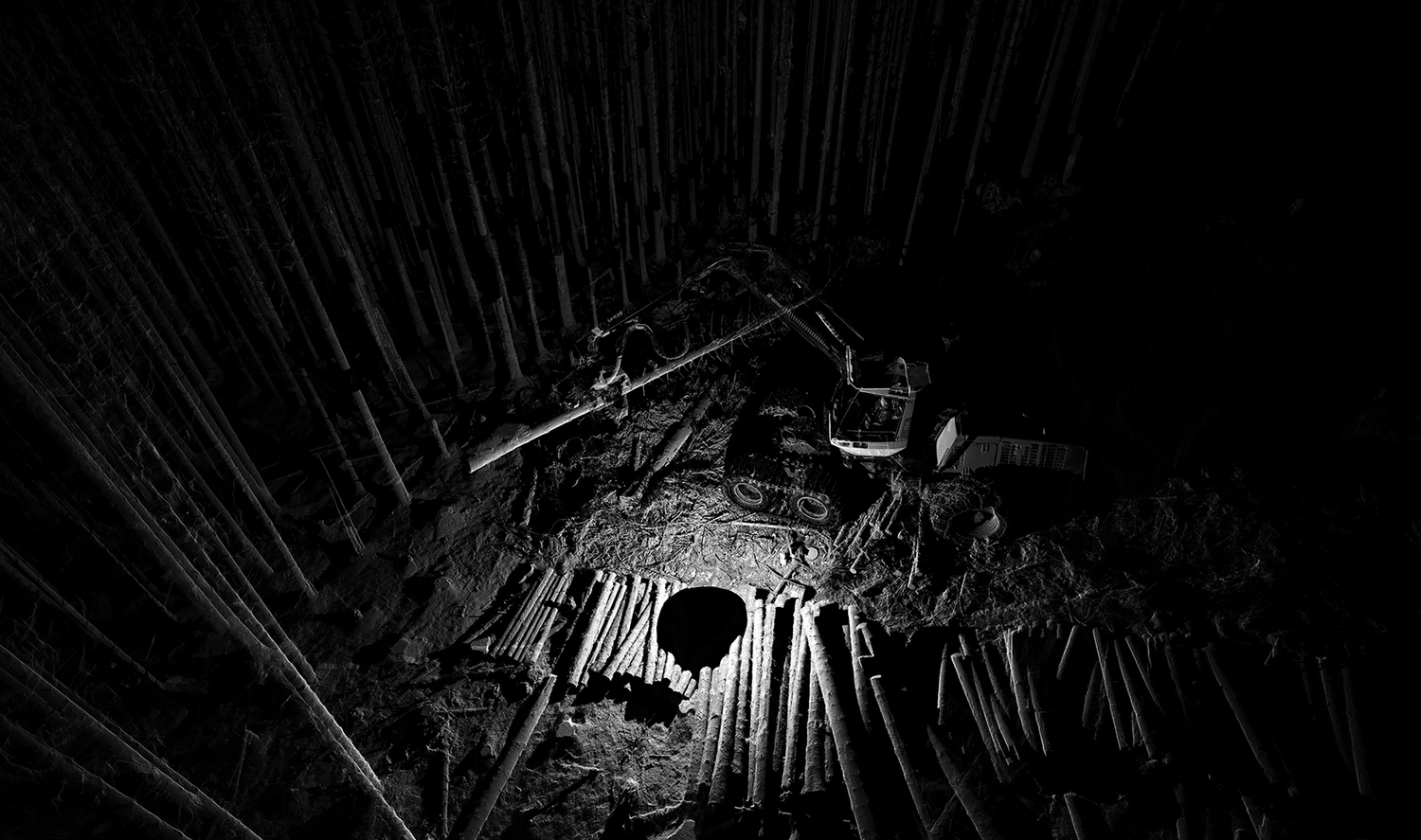
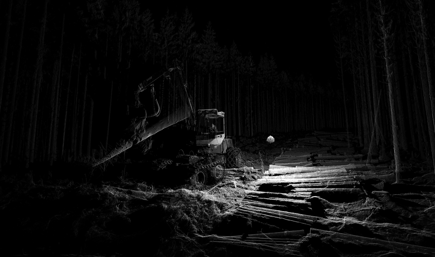