Every Room A Battlefield

[Image: Looking out over the center of “Razish,” a simulated city at the Fort Irwin National Training Center; photo by Geoff Manaugh.]

I had an opportunity to revisit the Fort Irwin National Training Center this weekend as part of a series of field trips I’ve put together for the Los Angeles-based Berggruen Institute’s Antikythera program. One of their major topics of discussion this spring is models and simulations.

[Image: Downtown Razish, part of the fictional nation of “Atropia”; photo by Geoff Manaugh.]

Fort Irwin is a U.S. Army base the size of Rhode Island, roughly three hours outside Los Angeles in the Mojave Desert. Already huge, Fort Irwin fits into a much larger jigsaw puzzle of other military lands, including Edwards Air Force Base and the Marine Corps Logistics Base Barstow, forming a truly vast, almost state-level presence in the mountains and desert.

Its scale and isolation make it an ideal setting for immersive training exercises, which are staged in a series of 14 simulated towns and cities.

[Image: A multistory reconfigurable plywood interior used for building-clearance operations at the Fort Irwin National Training Center; photo by Geoff Manaugh.]

My last trip to Fort Irwin was back in September 2012, long enough for significant changes to occur, both architecturally, in terms of the training center itself, and geopolitically, in terms of current events.

[Image: Views of “Razish” at the Fort Irwin National Training Center; photos by Geoff Manaugh.]

When I was there in 2012, our visitor group witnessed a staged combat scenario set in a small Afghan village; today’s geopolitical context has changed, resulting in a kind of theatrical shift in what—and who—is being simulated. In another post, I have referred to this as imperial dramaturgy: how we stage and engage with representations of our purported adversaries. Indeed, dramaturgy, stagecraft, and set design all offer a useful lens through which to understand politics—and, of course, also cast Fort Irwin in a different light, where members of the public are permitted to watch carefully orchestrated events whose purpose seems equally split between operatic braggadocio (“look what we can do!”) and practical fundraising (“here’s where your taxes go!”).

The city we visited on Friday is called “Razish,” the provincial capital of a fictional nation known as “Atropia.” With more than 750 individual buildings, some of which are five stories tall, and multiple tunnel complexes, Razish is not only much larger than the village market I saw back in 2012, but the signs are also now written in Cyrillic. Russian-speaking actors hired from a local jobs agency played live-action roles for us, including a gruff mayor and his monosyllabic chief of police; there were also upward of three dozen civilian residents whose job would soon become simply screaming out of sight for psychological effect as the simulated military operation began.

The aesthetic effect was that of a geopolitical uncanny valley: Razish was not Iraq or Iran, it looked nothing particularly like Russia, and it did not have Chinese characteristics, so to speak. It felt like a looking-glass version of a Central Asian breakaway republic, a windswept landscape of cinder blocks, cargo containers, and outdoor markets, with attack helicopters buzzing by in the distance. An ersatz mosque stood atop one hill, with strategic views of the surrounding terrain.

[Images: Photos by Geoff Manaugh.]

Idle speculation amongst some of my fellow visitors suggested that the Army was leaning into this portrayal of a Russian opponent as a deliberate feint or ruse, hiding the fact that the Army might be preparing for urban combat in Central Asia, sure, but likely with a different Asian nation-state in mind.

But rather than try to interpret what we saw in terms of its imperial messaging, I’ll stick with a brief description of the architectural experience. The building interiors were dense, modular labyrinths of rooms framed by plywood, their walls porous at various scales with doors, chutes, and openings. In some cases, trapdoors led up—or down—through the buildings along a different axis of approach, such that an unexpected ambush could be staged in nearly any spatial circumstance. Many walls were stenciled with warnings that they were load-bearing and not to be removed; others had “demo,” for demolish, spray-painted across them.

It seems highly likely that, upon future return, entirely different interiors would greet us, a continuously revised maze of threats and imminent violence.

[Images: Interiors at Fort Irwin; photos by Geoff Manaugh.]

We were able to speak with active-duty soldiers throughout the day, including over lunch, and I asked one of them about building-clearance operations and how it might differ from the simulated outdoor raid we had just seen performed. “Every room is a battlefield,” the soldier replied, noting that combat now often takes place inside architecture, not just on the muddy plains of vast continental interiors. This would be the “four-floor war” described elsewhere.

[Image: The back streets of Razish; photo by Geoff Manaugh.]

The Fort Irwin National Training Center offers public tours once a month, every spring and summer; interested visitors can sign up online.

My True Love Gave to Me…

[Image: U.S. Army soldiers “provide security while clearing an underground complex during dense urban environment training,” photo by Captain Scott Kuhn.]

I had missed this “urban warfare Christmas wish list” posted back in 2018, complete with specific but speculative tools for intra-architectural combat. Who doesn’t think about urban warfare on Christmas?

The list suggests developing a military-grade “industrial foam thrower” (perhaps suggesting a future black-market for used rave equipment). “I want an industrial foam-throwing gun,” John Spencer writes, “that will seal each opening as I find and move past them. Foam is already used to lift concrete house foundations, streets, and sidewalks in the private sector. Adapting this tool to the needs of the urban warrior would pay huge dividends.”

Spencer’s wish list continues: “I would want a mining robot that could drill or punch holes in walls in advance of my movements. The robot would have the software, data, and sensing capability to know where to go through walls most easily and with the least amount of damage.”

In fact, this gives me the perfect excuse to post something I’ve had bookmarked for years: remote controlled demolition robots. Husqvarna, for example, makes “a small and very versatile demolition robot that can be transported inside a van.” Surely, a militarized line of portable, remotely controlled demolition robots is just one purchase-order away from becoming reality.

The list continues. Spencer calls for wheeled barriers, allowing “concrete walls to roll directly off of a flatbed truck into position”; giant, grenade-launcher-deployed curtains for blocking entire streets and buildings from view (what he has elsewhere referred to as “an invisibility kit for urban combat”); and, among other things, military-grade jumper cables for tapping into the batteries of ruined cars left junked out on the street in order to power a unit’s portable electronic gear.

[Image: From Tenet, courtesy Warner Brothers.]

Spencer also hosts a podcast called the “Urban Warfare Project,” one episode of which adds another, somewhat Tenet-like piece of gear to this list: air tanks for prolonged missions in underground spaces. (In Christopher Nolan’s recent film, Tenet, the characters need to wear air tanks so that they can breathe while moving back in time.)

In any case, as I write in A Burglar’s Guide to the City, one of the reasons for studying these sorts of tools—whether they are military or criminal, whether they are used by firefighters or by demolition crews—is to understand both how works of architecture are internally connected and how those same structures can be dismantled.

Indeed, nearly every tool on Spencer’s list would also be of use for a sufficiently ambitious burglary crew—firing curtains across the street to hide entry and exit points, using demolition machines to break into vaults—but whether you pay attention to this stuff purely as an academic exercise or as a spur toward designing works of architecture that can resist, confuse, or baffle such equipment is up to you.

Check out the rest of Spencer’s list over at the Modern War Institute.

(Very vaguely related: Nakatomi Space.)

Tactical Geography

[Image: A map of the Battle of Villmanstrand (1741), via George III’s Collection of Military Maps, assembled by Yolande Hodson.)

A vast collection of old military maps has been made available online through the UK’s Royal Collection Trust, taken from the collection of King George III, thanks to the exhaustive work of Yolande Hodson. While the troop positions and tactical maneuvers they document are fascinating, the maps are also a spatial survey of building types, terrains, and urban plans, including star forts, walled villages, protected natural landscape features, from bays to river valleys, and other strategic environments.

As the blog Ian Visits explains, “Maps were an important part of George’s early life and education, and he built up a huge collection of more than 55,000 topographical, maritime and military prints, drawings, maps and charts. Upon the King’s death, his son, George IV, gave his father’s collections of topographical views and maritime charts to the British Museum (now in the British Library), but retained the military plans due to their strategic value and his own keen interest in the tactics of warfare.” The new website apparently documents a mere 3,000 of those documents.

The whole thing is searchable by conflict, which means that you can look specifically for maps related to, say, the Franco-Spanish War of 1635-59, including the Siege of Cremona (1648)—seen below—or, say, the Russo-Swedish War of 1741-43, which included the Battle of Villmanstrand (1741), the image that opens this post.

[Image: A map of the Siege of Cremona (1648), via George III’s Collection of Military Maps, assembled by Yolande Hodson.)

Perhaps even better, however, you can also click on maps by region, from North America to India to, of course, all over Europe and the Caribbean. This includes, among the thousands of examples, an incredible map from the American Revolution depicting New York City in all of its topographic glory.

[Image: Long Island, New York and Staten Island (1776), via George III’s Collection of Military Maps, assembled by Yolande Hodson.)

Indeed, as Ian Visits notes, “Highlights of the collection include two-metre-wide maps of the American War of Independence. These vast maps were probably hung on purpose-made mahogany stands in Buckingham House, enabling the King to follow the steady erosion of his hold on the American colonies.”

The collection is spectacular. The Siege of Memel (1757). The Siege of Olmütz (1758). A view of Gotha (1567). The Siege of Prague (1757). I could go on and on. The Plan of Pilau (1757). The Siege of Bangalore (1791)…

Check out the guide to the online catalog, then dive in.

(Vaguely related: Feral Cities, Indirect Streets, and Soft Fortification.)

Feral Cities, Indirect Streets, and Soft Fortification

[Image: “Thomas de Leu, engraver. Perspective view of an ideal city, 1602. From Jacques Perret, Architectura et perspectiva des fortifications & artifices de laques Perret. Courtesy CCA].

[Nearly a decade ago, I wrote a series of blog posts as part of a Fellowship at the Canadian Centre for Architecture. Those posts appear to be falling into an internet memory hole, so I thought I’d reproduce lightly edited versions of some of them here, simply for posterity.]

In 1564, the Tuscan urban planner, archaeologist, military theorist, mathematician, and writer Girolamo Maggi published a work of military urbanism called Della fortificatione delle città, written by his colleague Giacomo Fusto Castriotto.

That work, on the fortification of cities, devoted several passages to what might be called indirect or soft fortification: protecting an urban population from attack not through the use of heavy walls, inner citadels, or armed bastions—although the book is, of course, filled with such things—but through nothing more than a complex street plan.

Indirect streets and narrow walkways could be put to use, Castriotto argued, as agents of spatial disorientation, leading an invader everywhere but where they actually wanted to go. It was a kind of urban judo, or the city as martial art.

The city itself could be weaponized, in other words, its layout made militarily strategic: you could transform the speed at which your enemy arrives into exactly what would entrap him, lost, unable to retrace his footsteps, fatally vulnerable and spatially exposed.

The CCA exhibited much of its collected manuscripts on urban fortification seventeen years ago, under the name The Geometry of Defence: Fortification Treatises and Manuals, 1500–1800.

In the accompanying pamphlet, curator and former CCA historiographer Michael J. Lewis describes the geometric complexification that the fortified cities of the Renaissance underwent in the name of self-protection (Alberto Pérez-Gómez’s Architecture and the Crisis of Modern Science also contains a lengthy history of this same material and is worth consulting in full). A constantly shifting imbalance of power between the wall-builders and the invaders led to new spatializations of the metropolis. Whether due to the invention of gunpowder, massed assaults or simply new building techniques, the urban landscape was constantly reformatted according to the weapons that might be used against it.

Of course, this will be a very familiar story to most readers, so I don’t want to repeat it; I do, however, want to focus on the idea of forsaking mass—thick walls—for complexity in the name of strategic disorientation. There are well-known stories, for instance, of English coastal villages during World War II removing their road and street signs so as to prevent logical navigation by German aggressors, even erecting dummy signs to send confused Nazi paratroopers wandering off in the wrong direction.

But if the well-fortified Renaissance city could be seen, for the sake of argument, as something like the Hummer of military urbanism, what is the city-as-Bruce-Lee? A city that is lean, even physically underwhelming, but brilliantly fast and highly flexible? What is the city that needs no defensive walls at all?

[Image: “Unknown engraver. Series of views showing the development of the modern bastion system from its medieval origins. Plate A from Matthias Dögen, Matthiae Dögen Dramburgensis marchici Architectura militaris moderna, 1st ed. (Amsterdam, Ludovic Elzevir, 1647).” Courtesy CCA].

There are a variety of possible answers here, all of which would be interesting to discuss; but I’m most struck by the possibility that the phenomenon recently dubbed the “feral city” is, in a sense, an anti-fortress in precisely this spatial sense.

In a now-canonical 2003 paper for the Naval War College Review, author Richard J. Norton describes the feral city as “a great metropolis covering hundreds of square miles. Once a vital component in a national economy, this sprawling urban environment is now a vast collection of blighted buildings, an immense petri dish of both ancient and new diseases, a territory where the rule of law has long been replaced by near anarchy in which the only security available is that which is attained through brute power.”

From the perspective of a war planner or soldier, Norton explains, the feral city is spatially impenetrable; it is a maze resistant to aerial mapping and far too dangerous to explore on foot. Indeed, its “buildings, other structures, and subterranean spaces would offer nearly perfect protection from overhead sensors, whether satellites or unmanned aerial vehicles,” Norton writes, creating, in the process, an environment where soldiers are as likely to die from rabies, tetanus, and wild dog attacks as they are from armed combat.

I’m led to wonder here what a twenty-first-century defensive literature of the feral city might look like—from temporary barricades to cartographically incoherent slums experimenting with limited forms of micro-sovereignty. If the feral city is a city with no external walls but an infinite interior—endless spaces made of oblique architecture and indirect streets—then its ability to defend itself comes precisely through letting invaders in and fatally disorienting them, not by keeping them out.

So if a city does away with defensive walls altogether, what specific spatial strategies are left for it to protect itself? For instance, can a city deliberately be made feral as an act of preemptive self-defense—and, if so, what architectural steps would be necessary to achieve such a thing? Channeling Archigram—or perhaps even Cisco—we might call this the insurgent instant city complete with its own infrastructural practices, its own rogue designers, and its own anti-architects.

How, then, could the spatial practice of urban feralization be codified, and what architectural lessons might be learned if this were to happen?

Michael J. Lewis, describing the treatises on display at the CCA nearly two decades ago for The Geometry of Defence, refers to “fortification literature” or “the literature of the fortification,” including the publishing practices peculiar to this—for its time—top secret field of study. For example, privately circulated manuscripts, incomplete essayistic reflections, and even word-of-mouth gradually solidified into full-length narratives; only at that point were they intended to communicate finely tuned, often firsthand, military knowledge of a city under siege to anyone who might want to discover it, whether that was a king, a layperson, or an enemy general (indeed, much of the literature of fortification went on to the form the core of an emergent field known as urban planning).

In another fifty, one hundred, or even five hundred years, will there be a defensive literature of the feral city, its systematic description, techniques for its defense (or obliteration), and its urban logic (or lack thereof)? Even if only on the level of urban form, this would be a fascinating journey, going from Castriotto’s and Maggi’s indirect streets to whole cities gone wild in the name of resisting outside intervention.

War Simulant

[Image: From Battle: Los Angeles (2011)].

In an era when military action is increasingly shifting toward cities, it’s interesting to note that the U.S. Army is conducting drills in the skies above Los Angeles this week.

As NBC Los Angeles reports, the exercises are for “the purpose of enhancing soldier skills by operating in various urban environments and settings… Residents around the L.A. area may hear sounds associated with training, including aircraft and weapon simulations.”

Recall—as cited by Mike Davis in his book City of Quartz—that this is not the first time L.A. has been used as an urban-warfare simulator. “Scores of residents in the Bunker Hill and Civic Center areas complained of the racket Thursday night after several of the Army helicopters began maneuvering close to high-rise apartments and condominiums at about 10 p.m.,” the L.A. Times reported way back in 1989. At the time, these close-building maneuvers were meant to test “urban approach and departure techniques.”

(Thanks to Nicola Twilley for the tip!)

The Four-Floor War


[Image: Russian troops in Grozny, February 2000; image courtesy of AP].

“U.S. land forces will eventually find themselves locked in fights within huge, dense urban environments where skyscrapers tower over enormous shanty towns, and these troops need more realistic training to operate within these future megacities,” Brigadier General Julian Alford of the U.S. Marine Corps Warfighting Laboratory explained earlier this month, as reported by Defense News.

It’s war in the age of megacities: “We talk about the three-block war, but we are moving quickly to the four-floor war,” Alford adds.

We are going to be on the top floor of a skyscraper… evacuating civilians and helping people. The middle floor, we might be detaining really bad people that we’ve caught. On the first floor we will be down there killing them. …At the same time they will be getting away through the subway or subterrain. How do we train to fight that? Because it is coming, that fight right there is coming I do believe with all my heart.

The verticalization of Alford’s metaphor—“the four-floor war”—is an interesting revision of the existing “three-block war” paradigm. In that earlier version, U.S. General Charles C. Krulak suggested that three separate and very different military goals—humanitarian assistance, peace-keeping, and “traditional warfighting”—could all occur within only three blocks of one another in the urban combat of the future. In his words, soldiers would be confronted by “the entire spectrum of tactical challenges in the span of a few hours and within the space of three contiguous city blocks.”

This would not only be a problem of so-called “feral cities,” but of feral buildings within a functional metropolis.

The idea that this is now a “four-floor” problem—that “the entire spectrum of tactical challenges” could now be experienced within the space of four floors of a single high-rise—is a dark indicator not only that our own everyday surroundings are now being modeled and war-gamed as sites of speculative combat, but also how terrifying full-scale architectural warfare would be. Battling upward through the interior of skyscrapers, perhaps even zip-lining from one tower to another, it would be Nakatomi space taken to its logical, militarized extreme.

Recall Mike Davis’s observation from more than a decade ago that so-called Third World cities were being viewed as the “key battlespace of the future,” and that U.S. forces were thus preparing “for protracted combat in the near impassable, maze-like streets of the poverty-stricken cities of the Third World.” Davis elaborates on these points in an old interview with BLDGBLOG called Planet of Slums: An Interview with Mike Davis, Parts One and Two.

(Earlier on BLDGBLOG: Cities Under Siege.)

Out of the Mountains

[Image: David Kilcullen, from Out of the Mountains].

Military strategist David Kilcullen was in New York City earlier this week to talk about the future of urban warfare at the World Policy Institute. I tagged along to learn more about “future conflicts and future cities,” as Kilcullen describes it, and to see what really happens when urban environments fail: when cities fall apart or disintegrate into ungovernable canyons of semi-derelict buildings ruled by cartels, terrorist groups, and paramilitary gangs.

Kilcullen’s overall thesis is a compelling one: remote desert battlegrounds and impenetrable mountain tribal areas are not, in fact, where we will encounter the violence of tomorrow. For Kilcullen—indeed, for many military theorists writing today—the war in Afghanistan was not the new normal, but a kind of geographic fluke, an anomaly in the otherwise clear trend for conflicts of an increasingly urban nature.

The title of Kilcullen’s book—Out of the Mountains—suggests this. War is coming down from the wild edges of the world, driving back toward our lights and buildings from the unstructured void of the desert, and arriving, at full force, in the hearts of our cities, in our markets and streets. The recent siege in Nairobi and the Mumbai attacks, to name only two examples that came up in Kilcullen’s discussion, are evidence of the urbanization of violence and war. 

But if cities—particularly in the world’s coastal, developing regions—are a hotbed for future aggression, as Kilcullen and other military theorists suggest, then is it possible that we could somehow design away this growing problem? Kilcullen, a former soldier with the Australian military, said repeatedly that there is no military solution here. If we want to war-proof our cities, so to speak, then we’ll need more than guns and ammo.

So violence is coming down out of the mountains, Kilcullen explained, and it is taking root in the spaces of everyday life, in cities and suburbs where both infrastructure and governance have failed. This is the “future environment” or operational theater that military planners both fear and rigorously prepare for, one populated by feral cities—one of my favorite phrases of all time, coined in 2003 by Richard Norton—dystopian urban wastelands ruled over by loose constellations of gangs.

However, these same military planners are not the ones who should be most closely focused on the darkening horizon: rather, Kilcullen emphasized, we need to push civilian designers and professionals into thinking about “urban environments that are dramatically under stress,” as he phrased it during his talk. 

Kilcullen’s own professional role—a member of the executive team at Caerus Associates, a “strategy and design firm” working with architects and urban planners from its base in Washington D.C.—is, in and of itself, a vote of confidence in a non-military solution. “We help clients understand and thrive in complex, conflict-afflicted, and disaster-affected environments,” they write. 

[Image: David Kilcullen, from Out of the Mountains].

An articulate and precise speaker—his somewhat menacing message, of overpopulated cities trapped in death spirals, tempered only slightly by a soothing and intact Aussie accent—Kilcullen outlined where the cities of the world are going, how violence is following them, and where this conflict comes from in the first place. There were multiple take-aways. 

Crime is Warfare on Another Scale

There has been “a blurring of the distinction between crime and warfare” in urban environments, he pointed out. Armed gangs and paramilitary terrorist groups are blurring together. Look no further than cartel violence in northern Mexico and you can see that a sufficiently organized criminal is no different than a warlord.

We might say that a large enough crime spree is indistinguishable from an insurgency—a revolution against order in the city.

Feral Suburbs

It is not always correct to call these environments “cities,” on the other hand, nor to assume that all of the violence is, in fact, truly “urban”—rather, much of these conflicts are bred in what Kilcullen described as “diffuse” environments, or informal settlements on the “peri-urban” edge of the metropolis.

So, while we might say feral cities or cities gone wild, the problem is actually the violence of the diffuse and the decentered—the disorganized and the anti-urban—unexpectedly popping up in the city core.

Urban Embassies

We need to move beyond the nation-state and to think, instead, at the level of cities. Kilcullen here made the observation that, rather than having an India desk or an Egypt desk, for example, whether at a major newspaper or in the U.S. State Department, we should think much more specifically: assigning groups of analysts to particular conurbations for their unique urban needs. A Mumbai desk, a Nairobi desk.

As but one example, Kilcullen mentioned the NYPD has established what are, in effect, “New York embassies,” in Kilcullen’s words, in cities abroad. These overseas branches of the New York Police Department form a global circuit of city-to-city intelligence gathering operations; these are important sources of coordination and local expertise, both more subtle and far cheaper than a military operation.  

Even beyond this, Kilcullen emphasized the growing political importance of cities, as administrative units, and the urgency with which we need to understand their functioning. His analysis also suggests a new and surprising geopolitical actor in the world: the mayor. The mayor of a mega-city like New York can be far more important on the international stage than even the leader of a nation-state, and the city itself—whether it’s Lagos or Mexico City—can often punch far above the weight of the nation-state it’s found within. 

Failure From Above

During the Q&A, Kilcullen briefly mentioned the work of Crisis Mappers, who have developed tools for visually analyzing urban form using satellite photos. According to Kilcullen, they are able to do this with an astonishing degree of accuracy, diagnosing what parts of cities seem most prone to failure. Whether this is due to empty lots and abandoned buildings or to infrastructural isolation from the rest of the city, the factors that determine “ferality” in the built environment is a kind of aerial application of the Broken Windows theory.

The implication—conceptually fascinating, but by no means convincing, at least for me—was that we could, in theory, develop a visual algorithm for identifying environments tending toward failure, and thus find a way to intervene before things truly fall apart. Teams of architects with their own dedicated satellites could thus scan the cities of the world from above, algorithmically identifying urban regions prone to collapse, then intervening with a neighborhood redesign. It sounds great—it’s very high-tech and would make a great comic book—but it seems highly unlikely as the true way forward.  

In the end, then, it was this larger notion of “intervening” that became the elephant in the room. How is it to be done? What is intervention in the first place? How do we de-stress an urban landscape through design?

Again, this is something not achieved by blowing things up with cruise missiles, Kilcullen made clear, but by reorganizing the city, strengthening local lines of communication and governance, and treating urban planning as an alternative to war. 

In any case, Kilcullen himself is a better advocate of his ideas, and his book is a better place to start, delving into all of the above points in greater detail (and including further examples, such a series of drug raids in Kingston, Jamaica, and their spatial legacy in British colonialism).  

(This post originally appeared on Gizmodo; reproduced with permission.)

Cities Under Siege

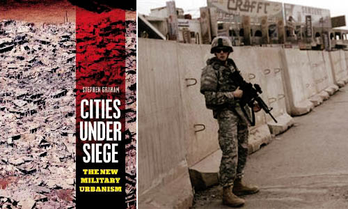
[Image: Stephen Graham’s Cities Under Siege].

In a 2003 paper for the Naval War College Review, author Richard J. Norton defined the term feral cities. “Imagine a great metropolis covering hundreds of square miles,” Norton begins, as if narrating the start of a film pitch. “Once a vital component in a national economy, this sprawling urban environment is now a vast collection of blighted buildings, an immense petri dish of both ancient and new diseases, a territory where the rule of law has long been replaced by near anarchy in which the only security available is that which is attained through brute power.”

With the city’s infrastructure having collapsed long ago—or perhaps having never been built in the first place—there are no works of public sanitation, no sewers, no licensed doctors, no reliable food supply, no electricity. The feral city is a kind of return to medievalism, we might say, back to the future of a dark age for anyone but criminals, gangs, and urban warlords. It is a space of illiterate power—strength unresponsive to rationality or political debate.

From the perspective of a war planner or soldier, the feral city is also spatially impenetrable, a maze resistant to aerial mapping. Indeed, its “buildings, other structures, and subterranean spaces, would offer nearly perfect protection from overhead sensors, whether satellites or unmanned aerial vehicles,” Norton writes.

This is something Russell W. Glenn, formerly of the RAND Corporation—an Air Force think tank based in Southern California—calls “combat in Hell.” In his 1996 report of that name, Glenn pointed out that “urban terrain confronts military commanders with a synergism of difficulties rarely found in other environments,” many of which are technological. For instance, the effects of radio communications and global positioning systems can be radically limited by dense concentrations of architecture, turning what might otherwise be an exotic experience of pedestrian urbanism into a claustrophobic labyrinth inhabited by unseen enemy combatants.

Add to this the fact that military ground operations of the near future are more likely to unfold in places like Sadr City, Iraq—not in paragons of city planning like Vancouver—and you have an environment in which soldiers are as likely to die from tetanus, rabies, and wild dog attacks, Norton suggests, as from actual armed combat.

Put another way, as Mike Davis wrote in Planet of Slums, “the cities of the future, rather than being made out of glass and steel as envisioned by earlier generations of urbanists, are instead largely constructed out of crude brick, straw, recycled plastic, cement blocks, and scrap wood. Instead of cities of light soaring toward heaven, much of the twenty-first-century urban world squats in squalor, surrounded by pollution, excrement, and decay.”

But feral cities are one thing, cities under siege are something else.
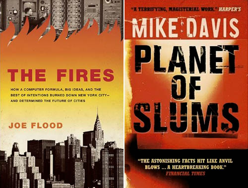
[Images: The Fires by Joe Flood and Planet of Slums by Mike Davis].

In his new book Cities Under Siege, published just two weeks ago, geographer Stephen Graham explores “the extension of military ideas of tracking, identification and targeting into the quotidian spaces and circulations of everyday life,” including “dramatic attempts to translate long-standing military dreams of high-tech omniscience and rationality into the governance of urban civil society.” This is just part of a “deepening crossover between urbanism and militarism,” one that will only become more pronounced, Graham fears, over time.

One particularly fascinating example of this encroachment of “military dreams… into the governance of urban civil society” is actually the subject of a forthcoming book by Joe Flood. The Fires tells the story of “an alluring proposal” offered by the RAND Corporation, back in 1968, “to a city on the brink of economic collapse [New York City]: using RAND’s computer models, which had been successfully implemented in high-level military operations, the city could save millions of dollars by establishing more efficient public services.” But all did not go as planned:

Over the next decade—a time New York City firefighters would refer to as “The War Years”—a series of fires swept through the South Bronx, the Lower East Side, Harlem, and Brooklyn, gutting whole neighborhoods, killing more than two thousand people and displacing hundreds of thousands. Conventional wisdom would blame arson, but these fires were the result of something altogether different: the intentional withdrawal of fire protection from the city’s poorest neighborhoods—all based on RAND’s computer modeling systems.

In any case, Graham’s interest is in the city as target, both of military operations and of political demonization. In other words, cities themselves are portrayed “as intrinsically threatening or problematic places,” Graham writes, and thus feared as sites of economic poverty, moral failure, sexual transgression, rampant criminality, and worse (something also addressed in detail by Steve Macek’s book Urban Nightmares). All cities, we are meant to believe, already exist in a state of marginal ferality. I’m reminded here of Frank Lloyd Wright’s oft-repeated remark that “the modern city is a place for banking and prostitution and very little else.”

In some of the book’s most interesting sections, Graham tracks the growth of urban surveillance and the global “homeland security market.” He points out that major urban events—like G8 conferences, the Olympics, and the World Cup, among many others—offer politically unique opportunities for the installation of advanced tracking, surveillance, and facial-recognition technologies. Deployed in the name of temporary security, however, these technologies are often left in place when the event is over: a kind of permanent crisis, in all but name, takes over the city, with remnant, military-grade surveillance technologies gazing down upon the streets (and embedded in the city’s telecommunications infrastructure). A moment of exception becomes the norm.

Graham outlines a number of dystopian scenarios here, including one in which “swarms of tiny, armed drones, equipped with advanced sensors and communicating with each other, will thus be deployed to loiter permanently above the streets, deserts, and highways” of cities around the world, moving us toward a future where “militarized techniques of tracking and targeting must permanently colonize the city landscape and the spaces of everyday life.”

In the process, any real distinction between a “homeland” and its “colonies” is irreparably blurred. Here, he quotes Michel Foucault: “A whole series of colonial models was brought back to the West, and the result was that the West could practice something resembling colonization, or an internal colonialism, on itself.” If it works in Baghdad, the assumption goes, then let’s try it out in Detroit.

This is just one of many “boomerang effects” from militarized urban experiments overseas, Graham writes.
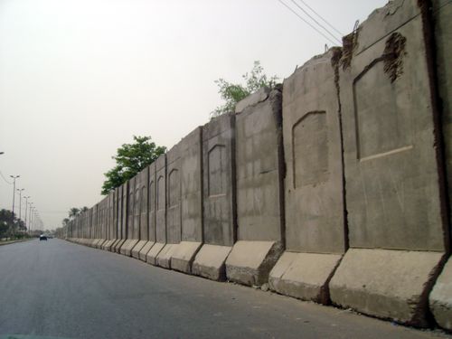
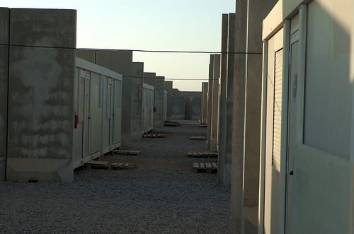
[Images: Blast walls in Iraq].

But what does this emerging city—this city under siege—actually look like? What is its architecture, its urban design, its local codes? What is its infrastructure?

Graham has many evocative answers for this. The city under siege is a place in which “hard, military-style borders, fences and checkpoints around defended enclaves and ‘security zones,’ superimposed on the wider and more open city, are proliferating.”

Jersey-barrier blast walls, identity checkpoints, computerized CCTV, biometric surveillance and military styles of access control protect archipelagos of fortified social, economic, political or military centers from an outside deemed unruly, impoverished and dangerous. In the most extreme examples, these encompass green zones, military prisons, ethnic and sectarian neighborhoods and military bases; they are growing around strategic financial districts, embassies, tourist and consumption spaces, airport and port complexes, sports arenas, gated communities and export processing zones.

Cities Under Siege also extensively covers urban warfare, a topic that intensely interests me. From Graham’s chapter “War Re-Enters the City”:

Indeed, almost unnoticed within “civil” urban social science, a shadow system of military urban research is rapidly being established, funded by Western military research budgets. As Keith Dickson, a US military theorist of urban warfare, puts it, the increasing perception within Western militaries is that “for Western military forces, asymmetric warfare in urban areas will be the greatest challenge of this century… The city will be the strategic high ground—whoever controls it will dictate the course of future events in the world.”

Ralph Peters phrased this perhaps most dramatically when he wrote, back in 1996 for the U.S. Army War College Quarterly, that “the future of warfare lies in the streets, sewers, high-rise buildings, industrial parks, and the sprawl of houses, shacks, and shelters that form the broken cities of our world.” The future of warfare, that is, lies in feral cities.

In this context, Graham catalogs the numerous ways in which “aggressive physical restructuring,” as well as “violent reorganization of the city,” is used, and has been used throughout history, as a means of securing and/or controlling a city’s population. At its most extreme, Graham calls this “place annihilation.” The architectural redesign of cities can thus be used as a military policing tactic as much as it can be discussed as a topic in academic planning debates. There are clearly echoes of Eyal Weizman in this.

On one level, these latter points are obvious: small infrastructural gestures, like public lighting, can transform alleyways from zones of impending crime to walkways safe for pedestrian use—and, in the process, expand political control and urban police presence into that terrain. But, as someone who does not want to be attacked in an alleyway any time soon, I find it very positive indeed when the cityscape around me becomes both safer by design and better policed. Equally obvious, though, when these sorts of interventions are scaled-up—from public lighting, say, to armed checkpoints in a militarized reorganization of the urban fabric—then something very drastic, and very wrong, is occurring in the city. Instead of a city simply with more cops (or fire departments), you begin a dark transition toward a “city under siege.”

I could go on at much greater length about all of this—but suffice it to say that Cities Under Siege covers a huge array of material, from the popularity of SUVs in cities to the blast-wall geographies of Baghdad, from ASBOs in London to drone helicopters in the skies above New York. Raytheon’s e-Borders program opens the book, and Graham closes it all with a discussion of “countergeographies.”

(Parts of this post, on feral cities, originally appeared in AD: Architectures of the Near Future, edited by Nic Clear).