Every Room A Battlefield

[Image: Looking out over the center of “Razish,” a simulated city at the Fort Irwin National Training Center; photo by Geoff Manaugh.]

I had an opportunity to revisit the Fort Irwin National Training Center this weekend as part of a series of field trips I’ve put together for the Los Angeles-based Berggruen Institute’s Antikythera program. One of their major topics of discussion this spring is models and simulations.

[Image: Downtown Razish, part of the fictional nation of “Atropia”; photo by Geoff Manaugh.]

Fort Irwin is a U.S. Army base the size of Rhode Island, roughly three hours outside Los Angeles in the Mojave Desert. Already huge, Fort Irwin fits into a much larger jigsaw puzzle of other military lands, including Edwards Air Force Base and the Marine Corps Logistics Base Barstow, forming a truly vast, almost state-level presence in the mountains and desert.

Its scale and isolation make it an ideal setting for immersive training exercises, which are staged in a series of 14 simulated towns and cities.

[Image: A multistory reconfigurable plywood interior used for building-clearance operations at the Fort Irwin National Training Center; photo by Geoff Manaugh.]

My last trip to Fort Irwin was back in September 2012, long enough for significant changes to occur, both architecturally, in terms of the training center itself, and geopolitically, in terms of current events.

[Image: Views of “Razish” at the Fort Irwin National Training Center; photos by Geoff Manaugh.]

When I was there in 2012, our visitor group witnessed a staged combat scenario set in a small Afghan village; today’s geopolitical context has changed, resulting in a kind of theatrical shift in what—and who—is being simulated. In another post, I have referred to this as imperial dramaturgy: how we stage and engage with representations of our purported adversaries. Indeed, dramaturgy, stagecraft, and set design all offer a useful lens through which to understand politics—and, of course, also cast Fort Irwin in a different light, where members of the public are permitted to watch carefully orchestrated events whose purpose seems equally split between operatic braggadocio (“look what we can do!”) and practical fundraising (“here’s where your taxes go!”).

The city we visited on Friday is called “Razish,” the provincial capital of a fictional nation known as “Atropia.” With more than 750 individual buildings, some of which are five stories tall, and multiple tunnel complexes, Razish is not only much larger than the village market I saw back in 2012, but the signs are also now written in Cyrillic. Russian-speaking actors hired from a local jobs agency played live-action roles for us, including a gruff mayor and his monosyllabic chief of police; there were also upward of three dozen civilian residents whose job would soon become simply screaming out of sight for psychological effect as the simulated military operation began.

The aesthetic effect was that of a geopolitical uncanny valley: Razish was not Iraq or Iran, it looked nothing particularly like Russia, and it did not have Chinese characteristics, so to speak. It felt like a looking-glass version of a Central Asian breakaway republic, a windswept landscape of cinder blocks, cargo containers, and outdoor markets, with attack helicopters buzzing by in the distance. An ersatz mosque stood atop one hill, with strategic views of the surrounding terrain.

[Images: Photos by Geoff Manaugh.]

Idle speculation amongst some of my fellow visitors suggested that the Army was leaning into this portrayal of a Russian opponent as a deliberate feint or ruse, hiding the fact that the Army might be preparing for urban combat in Central Asia, sure, but likely with a different Asian nation-state in mind.

But rather than try to interpret what we saw in terms of its imperial messaging, I’ll stick with a brief description of the architectural experience. The building interiors were dense, modular labyrinths of rooms framed by plywood, their walls porous at various scales with doors, chutes, and openings. In some cases, trapdoors led up—or down—through the buildings along a different axis of approach, such that an unexpected ambush could be staged in nearly any spatial circumstance. Many walls were stenciled with warnings that they were load-bearing and not to be removed; others had “demo,” for demolish, spray-painted across them.

It seems highly likely that, upon future return, entirely different interiors would greet us, a continuously revised maze of threats and imminent violence.

[Images: Interiors at Fort Irwin; photos by Geoff Manaugh.]

We were able to speak with active-duty soldiers throughout the day, including over lunch, and I asked one of them about building-clearance operations and how it might differ from the simulated outdoor raid we had just seen performed. “Every room is a battlefield,” the soldier replied, noting that combat now often takes place inside architecture, not just on the muddy plains of vast continental interiors. This would be the “four-floor war” described elsewhere.

[Image: The back streets of Razish; photo by Geoff Manaugh.]

The Fort Irwin National Training Center offers public tours once a month, every spring and summer; interested visitors can sign up online.

Feral Cities, Indirect Streets, and Soft Fortification

[Image: “Thomas de Leu, engraver. Perspective view of an ideal city, 1602. From Jacques Perret, Architectura et perspectiva des fortifications & artifices de laques Perret. Courtesy CCA].

[Nearly a decade ago, I wrote a series of blog posts as part of a Fellowship at the Canadian Centre for Architecture. Those posts appear to be falling into an internet memory hole, so I thought I’d reproduce lightly edited versions of some of them here, simply for posterity.]

In 1564, the Tuscan urban planner, archaeologist, military theorist, mathematician, and writer Girolamo Maggi published a work of military urbanism called Della fortificatione delle città, written by his colleague Giacomo Fusto Castriotto.

That work, on the fortification of cities, devoted several passages to what might be called indirect or soft fortification: protecting an urban population from attack not through the use of heavy walls, inner citadels, or armed bastions—although the book is, of course, filled with such things—but through nothing more than a complex street plan.

Indirect streets and narrow walkways could be put to use, Castriotto argued, as agents of spatial disorientation, leading an invader everywhere but where they actually wanted to go. It was a kind of urban judo, or the city as martial art.

The city itself could be weaponized, in other words, its layout made militarily strategic: you could transform the speed at which your enemy arrives into exactly what would entrap him, lost, unable to retrace his footsteps, fatally vulnerable and spatially exposed.

The CCA exhibited much of its collected manuscripts on urban fortification seventeen years ago, under the name The Geometry of Defence: Fortification Treatises and Manuals, 1500–1800.

In the accompanying pamphlet, curator and former CCA historiographer Michael J. Lewis describes the geometric complexification that the fortified cities of the Renaissance underwent in the name of self-protection (Alberto Pérez-Gómez’s Architecture and the Crisis of Modern Science also contains a lengthy history of this same material and is worth consulting in full). A constantly shifting imbalance of power between the wall-builders and the invaders led to new spatializations of the metropolis. Whether due to the invention of gunpowder, massed assaults or simply new building techniques, the urban landscape was constantly reformatted according to the weapons that might be used against it.

Of course, this will be a very familiar story to most readers, so I don’t want to repeat it; I do, however, want to focus on the idea of forsaking mass—thick walls—for complexity in the name of strategic disorientation. There are well-known stories, for instance, of English coastal villages during World War II removing their road and street signs so as to prevent logical navigation by German aggressors, even erecting dummy signs to send confused Nazi paratroopers wandering off in the wrong direction.

But if the well-fortified Renaissance city could be seen, for the sake of argument, as something like the Hummer of military urbanism, what is the city-as-Bruce-Lee? A city that is lean, even physically underwhelming, but brilliantly fast and highly flexible? What is the city that needs no defensive walls at all?

[Image: “Unknown engraver. Series of views showing the development of the modern bastion system from its medieval origins. Plate A from Matthias Dögen, Matthiae Dögen Dramburgensis marchici Architectura militaris moderna, 1st ed. (Amsterdam, Ludovic Elzevir, 1647).” Courtesy CCA].

There are a variety of possible answers here, all of which would be interesting to discuss; but I’m most struck by the possibility that the phenomenon recently dubbed the “feral city” is, in a sense, an anti-fortress in precisely this spatial sense.

In a now-canonical 2003 paper for the Naval War College Review, author Richard J. Norton describes the feral city as “a great metropolis covering hundreds of square miles. Once a vital component in a national economy, this sprawling urban environment is now a vast collection of blighted buildings, an immense petri dish of both ancient and new diseases, a territory where the rule of law has long been replaced by near anarchy in which the only security available is that which is attained through brute power.”

From the perspective of a war planner or soldier, Norton explains, the feral city is spatially impenetrable; it is a maze resistant to aerial mapping and far too dangerous to explore on foot. Indeed, its “buildings, other structures, and subterranean spaces would offer nearly perfect protection from overhead sensors, whether satellites or unmanned aerial vehicles,” Norton writes, creating, in the process, an environment where soldiers are as likely to die from rabies, tetanus, and wild dog attacks as they are from armed combat.

I’m led to wonder here what a twenty-first-century defensive literature of the feral city might look like—from temporary barricades to cartographically incoherent slums experimenting with limited forms of micro-sovereignty. If the feral city is a city with no external walls but an infinite interior—endless spaces made of oblique architecture and indirect streets—then its ability to defend itself comes precisely through letting invaders in and fatally disorienting them, not by keeping them out.

So if a city does away with defensive walls altogether, what specific spatial strategies are left for it to protect itself? For instance, can a city deliberately be made feral as an act of preemptive self-defense—and, if so, what architectural steps would be necessary to achieve such a thing? Channeling Archigram—or perhaps even Cisco—we might call this the insurgent instant city complete with its own infrastructural practices, its own rogue designers, and its own anti-architects.

How, then, could the spatial practice of urban feralization be codified, and what architectural lessons might be learned if this were to happen?

Michael J. Lewis, describing the treatises on display at the CCA nearly two decades ago for The Geometry of Defence, refers to “fortification literature” or “the literature of the fortification,” including the publishing practices peculiar to this—for its time—top secret field of study. For example, privately circulated manuscripts, incomplete essayistic reflections, and even word-of-mouth gradually solidified into full-length narratives; only at that point were they intended to communicate finely tuned, often firsthand, military knowledge of a city under siege to anyone who might want to discover it, whether that was a king, a layperson, or an enemy general (indeed, much of the literature of fortification went on to the form the core of an emergent field known as urban planning).

In another fifty, one hundred, or even five hundred years, will there be a defensive literature of the feral city, its systematic description, techniques for its defense (or obliteration), and its urban logic (or lack thereof)? Even if only on the level of urban form, this would be a fascinating journey, going from Castriotto’s and Maggi’s indirect streets to whole cities gone wild in the name of resisting outside intervention.

Immersive and Oceanic

By now you’ve no doubt seen Hyper-Reality, the new short film produced by visualization wunderkind Keiichi Matsuda, whose early video experiments, produced while still a student at the Bartlett School of Architecture, I posted about here a long while back.


As you can see in the embedded video, above, Matsuda’s film is a POV exploration of information overload, identity gamification, and the mass burial of public space beneath impenetrable curtains of privately relevant, interactive marketing data, all cranked up to the level of cacophony; when it all shuts off at one point, leaving viewers stranded in a nearly silent, everyday supermarket, the effect is almost therapeutic, an intensely relieving escape back to cognition free from popup ads.

[Image: From Hyper-Reality by Keiichi Matsuda].

I was reminded of Matsuda’s film, however, by the recent news that so-called heads-up displays, or HUDs, are coming to an underwater experience near you: the U.S. Navy has developed an augmented reality helmet for undersea missions.

This unique system enables divers to have real-time visual display of everything from sector sonar (real-time topside view of the diver’s location and dive site), text messages, diagrams, photographs and even augmented reality videos. Having real-time operational data enables them to be more effective and safe in their missions—providing expanded situational awareness and increased accuracy in navigating to a target such as a ship, downed aircraft, or other objects of interest.

Wandering among enemy seamounts, swimming through immersive 3-dimensional visualizations of currents and tides, watching instructional videos for how to infiltrate an adversary’s port defenses, the U.S. Navy attack crews of the near-future will be like characters in an aquatic Hyper-Reality, negotiating drop-down menus and the threat of moray eels simultaneously.

[Image: From Hyper-Reality by Keiichi Matsuda].

This raises the question of how future landscape architects, given undersea terrains as a possible target of design, might use augmented reality on the seabed.

Recall the preservation program underway today in the Baltic Sea, whereby historically valuable shipwrecks are being given interpretive signage to remind people—that is, possible looters—that what they are seeing down there is not mere debris. They are, in effect, swimming amidst an open-water museum, a gallery of the lost and sunken.

So here’s to someone visualizing the augmented reality underwater shipwreck museum of tomorrow, narratives of immersive data gone oceanic.

Machine Quarantines and “Persistent Drones”

scout[Image: An otherwise unrelated photo of a “Scout” UAV, via Wikipedia].

There’s an interesting short piece by Jacob Hambling in a recent issue of New Scientist about the use of “persistent drones” to “hold territory in war zones,” effectively sealing those regions off from incursion. It is an ominous vision of what we might call automated quarantine, or a cordon it’s nearly impossible to trespass, maintained by self-charging machines.

Pointing out the limitations of traditional air power and the tactical, as well as political, difficulties in getting “boots on the ground” in conflict zones, Hambling suggests that military powers might turn to the use of “persistent drones” that “could sit on buildings or trees and keep watch indefinitely.” Doing so “expands the potential for intervention without foot soldiers,” he adds, “but it may lessen the inhibitions that can stop military action.”

Indeed, it’s relatively easy to imagine a near-future scenario in which a sovereign or sub-sovereign power—a networked insurgent force—could attempt to claim territory using Hambling’s “persistent drones,” as if playing Go with fully armed, semi-autonomous machines. They rid the land of its human inhabitants—then watch and wait.

Whole neighborhoods of cities, disputed terrains on the borders of existing nations, National Wildlife Refuges—almost as an afterthought, in a kind of political terraforming, you could simply send in a cloud of machine-sentinels to clear and hold ground until the day, assuming it ever comes, that your actual human forces can arrive.

Bomblight

Los_Angeles_Civic_Center_buildings_by_Nevada_A_Bomb_blast_1955[Image: “Los Angeles Civic Center buildings by Nevada A Bomb blast, 1955,” courtesy USC Libraries/Los Angeles Examiner Collection].

I first saw this photo back in August while searching through the archives at USC as part of the recent L.A.T.B.D. project, and was floored. The caption is awesomely, stunningly blunt: “Los Angeles Civic Center buildings by Nevada A Bomb blast, 1955.” A metropolis lit up by a weaponized sun.

Coverage at the time was Homeric and naive, with talk of two dawns ascending over the city—violent and stroboscopic, rather than the rosy-fingered morning of Greek myth—as this experimental sunrise detonated in the neighboring deserts of Nevada.

TwoDawns[Image: “Los Angeles had two dawns yesterday…” from the Los Angeles Examiner, courtesy USC Libraries/Los Angeles Examiner Collection].

In any case, I’ve written a short post over at KCET about the photo, so check it out if you get a chance.

The Mirror War and the Light Brigade

MirrorFire-sm[Image: A cosmetically touched-up view of villages being set alight by mirrors; view slightly larger. From Deliciae physico (1636) by Daniel Schwenter].

Perhaps you remember the Austrian village of Rattenberg, so thoroughly hidden in the mountain shadows every winter that it installed a huge system of mirrors to bring the sun back in. The town of Rjukan, Norway, recently experimented with the same thing.

“High on the mountain opposite,” the Guardian reported back in 2013, “450 metres above the town, three large, solar-powered, computer-controlled mirrors steadily track the movement of the sun across the sky, reflecting its rays down on to the square and bathing it in bright sunlight.”

A far more sinister version of this exact sort of system was illustrated in a German book called Deliciae physico, published back in 1636, by Daniel Schwenter.

There, a woodcut shows a kind of reflective super-weapon mounted atop pillars, made of concave mirrors and magnifying lenses, setting fire to two distant buildings simultaneously the way a bumbling child might torture ants.

MirrorFire-big[Image: The full original page; view larger. From Deliciae physico (1636) by Daniel Schwenter].

Interestingly, this Apollonian death ray—a frighteningly literal light brigade—is presented in the book’s much larger context of telescopes, astronomy, and other optical devices, including distorting mirrors and cameras obscura.

Check out all 650 pages of the book here, courtesy of the U.S. Library of Congress, including some very cool images.

(Originally spotted via the excellent Twitter feed, @HistAstro).

Mehrangarh Fort

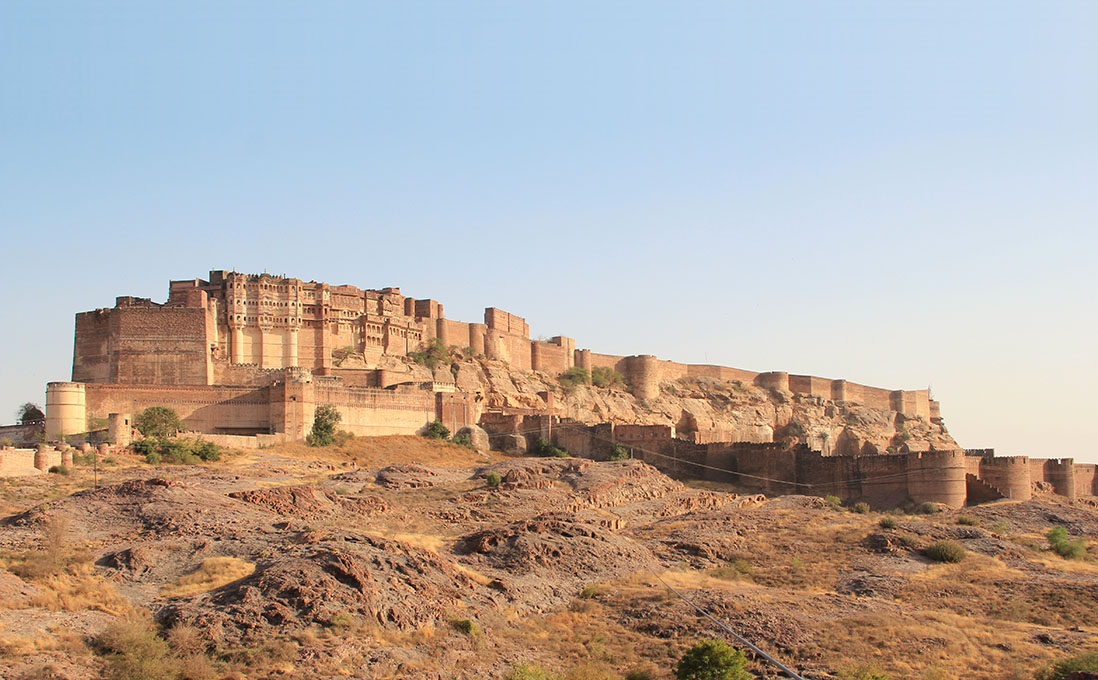
[Image: Mehrangarh Fort, Jodhpur, Rajasthan, India; photo by BLDGBLOG (view larger)].

Continuing with the recent series of posts showing photos from India—with apologies in advance for anyone who doesn’t want to see these, as I will doubtless keep going for at least several more posts—here are some photos from the utterly fantastic 15th-century Mehrangarh Fort in Jodhpur, Rajasthan.

[Image: Mehrangarh Fort, Jodhpur; photo by BLDGBLOG].

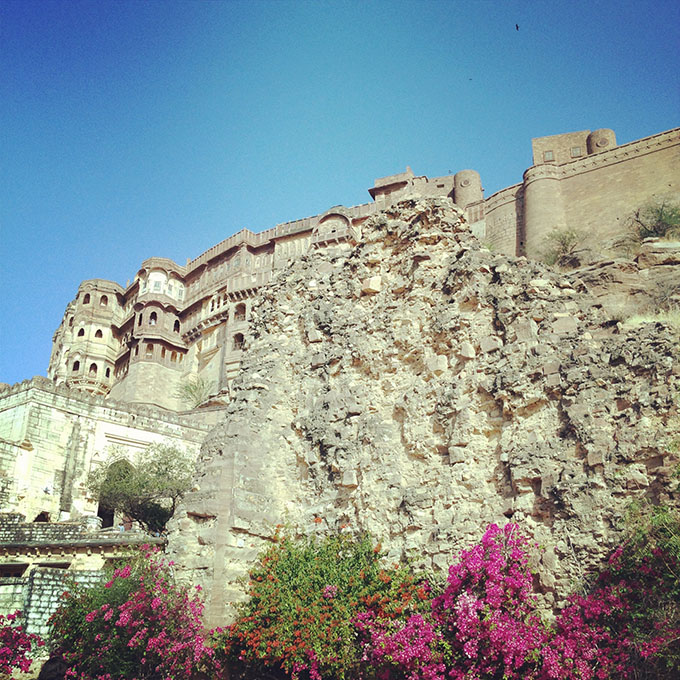
Mehrangarh is a massive hillside castle on a rocky site filled with moats, walls, battlements, gardens (holding what was described to us, rightly or wrongly, as one of India’s first pomegranate trees), an elaborate palace of balconies, arched galleries, and heavily ornamented private residences, and seemingly miles of strategically twisty, misleading passageways and stairs.

[Image: Inside Mehrangarh Fort, Jodhpur; photo by BLDGBLOG].

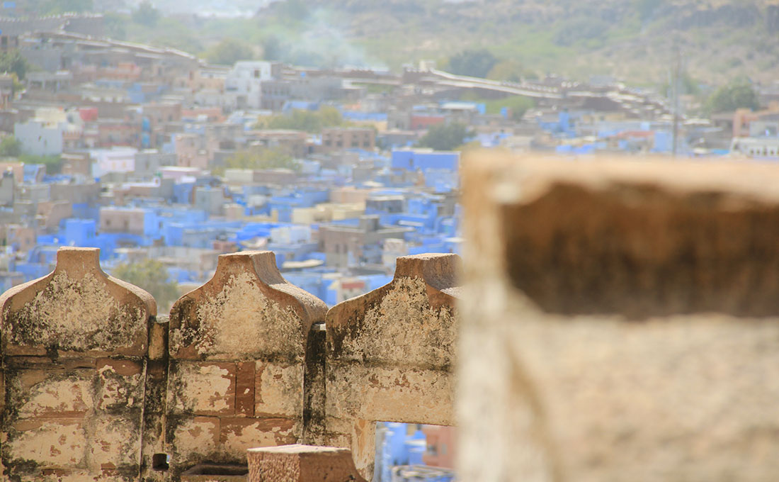
All of it overlooks a sprawling desert city lined with the beautiful blue-washed houses of local brahmins.

[Images: Overlooking Jodhpur, including the city’s many blue brahmin houses; photos by BLDGBLOG].

Nicola Twilley and I spent the entire day wandering out from our hotel through often absurdly narrow streets, down to the city’s broad central marketplace and back—

[Images: Walking around Jodhpur; photos by BLDGBLOG].

—heading up and around again to the fort itself, that hangs over everything like a ship.

[Image: Mehrangarh Fort, Jodhpur, as seen from our hotel; photo by BLDGBLOG].

As I believe the next post—or, at least, a future post at some point—will show, we even did some zip-line tourism over the moats and castle walls…

[Image: Birds flying over Mehrangarh Fort, Jodhpur; photo by BLDGBLOG].

For now, though, here are many, many, many, many photographs, mixing both DSLR and Instagram (where I am bldgblog, if you want to follow my feed).

[Image: Inside Mehrangarh Fort, Jodhpur; photo by BLDGBLOG].

However, for the sake of not spending the entire day captioning these images, I will simply let the photos themselves tell the story of our visit. Note, though, because I particularly like this detail, that the spike-studded door you’ll see pictured down below is found at the end of a very long, slowly rising ramp, but that that the door itself is installed 90-degrees off from the angle of direct approach. This right angle dramatically reduced the threat (and velocity) of direct charges from battle-elephants, who would thus have been forced to turn extremely quickly in order to collide with the door at all (and, even if the elephant could pivot successfully, it would then ram its head onto the spikes).

Details like this—let alone the dust-covered otherworldly feel of the entire place—give any castle in Europe a run for its money. At times, Mehrangarh felt like a Norman castle—or remote Welsh keep—on steroids (but wait till you see the even more massive and remote fortress of Kumbhalgarh, photos of which I’ll also post soon).

[Images: Mehrangarh Fort, Jodhpur; photos by BLDGBLOG].

Anyway, here are some images.

[Images: Mehrangarh Fort, Jodhpur; photos by BLDGBLOG].

Meanwhile, don’t miss recent posts exploring Chand Baori and the Raniji Ki stepwell.

Tunnel / Countertunnel

For a variety of reasons, I was recently looking at a May 2011 report from the Air Force Research Laboratory on “Robotics: Research and Development.”

[Image: From an Air Force Research Laboratory presentation on “Robotics: Research and Development”].

There—amidst plans for unmanned robotic ground convoys and autonomous perimeter defense systems for future bases and cities, not to mention fleets of robotic bulldozers field-tested for use in mine-clearance operations—there was one slide about something called “counter tunnel robotics.”

Being obsessed with all things underground, this immediately caught my eye—especially as this is a program whose goal is to “develop an unmanned system with the capability to access, traverse, navigate, map, survey, and disrupt operations in rough subterranean environments.” A “miniature mapping payload” is under development, one that will allow for accurate cartographic surveys of complex underground spaces; but, because current methods “will not work in the more challenging (non-planar) tunnel environments,” the Air Force explains, the new focus for R&D “will be on developing 3D mapping techniques using 3D sensors.”

From last month’s Association for Unmanned Vehicle Systems International—or AUVSI—conference in Washington D.C., where this technology was discussed in detail:

The [Counter Tunnel Robotics] system is an innovative all-terrain mobility platform capable of accessing tunnel systems through a small (8 inch) borehole and traversing adverse tunnel terrain including vertical obstacles up to 2ft in height and chasms up to 2ft in length. The system’s function is to provide a platform capable of carrying a small sensor package while navigating and overcoming terrain obstacles inside the tunnel. Counter tunnel technologies are needed to support intelligence gathering and safety of troops and personnel in unmapped and unknown tunnel environments. The system is the initial step in achieving a fully autonomous counter tunnel system.

A few things worth pointing out here include the mind-boggling image of “a fully autonomous counter tunnel system” operating on its own somewhere inside the earth’s surface, like something out of a Jonathan Lethem novel, surely fueling the imaginations of scifi screenplay writers the world over—a planet infested with artificially intelligent tunneling machines. But it is also worth noting that these systems will very likely not be confined to use on—or in—the earth. In fact, autonomous tunnel-exploration robots will find a very hearty market for themselves exploring caves on the moon, on Mars, on asteroids, and perhaps elsewhere, in a fairly clear-cut example of military research finding a productive home for itself in other contexts.

However, I also want to mention how fascinating it is to see that the Air Force Research Laboratory is involved in this, as it actually penetrates the surface of the earth and is very much a project of the ground. It is a landscape project. But the implication here is that these autonomous spelunking units are perhaps seen as a new type of ordnance—that is, they are intelligent bombs that don’t explode so much as explore. They are artillery and surveillance rolled into one. Imagine a bomb that doesn’t destroy a building: instead, it drops into that building and proceeds to map every room and hallway.

But, much more interestingly, there is perhaps also an indication here that a conceptual revolution is underway within the Air Force, where the earth itself—geological space—is seen as merely a thicker version of the sky. That is, the ground is now seen by Air Force strategists as an abstract, three-dimensional space through which machines can operate, like planes in the sky, navigating past “terrain obstacles” like so much turbulence. In a sense, the inside of the earth becomes ontologically—and, certainly, technically—identical to the atmosphere: it is an undifferentiated space that can be traversed in all directions by the appropriate machinery.

Flying and tunneling thus become elided, revealed as one and the same activity; and the Air Force is understandably now in the business of the underground.

[Image: “A U.S. Air Force F-22A Raptor Stealth Fighter Jet Executes A Maneuver Through A Cloud Of Vapor”—that is, it tunnels through the sky—”At The 42nd Naval Base Ventura County Air Show, April 1, 2007, Point Mugu, State of California, USA”; photo by Technical Sgt. Alex Koenig, United States Air Force; Courtesy of Defense Visual Information and the United States Department of Defense].

That, of course, or it was simply an issue of the wrong office receiving research funds for this, and, next fiscal quarter, the Army dutifully takes over…

(For a bit more on underground military activity, see this older post on BLDGBLOG).

Terrain Deformation Grenades

Something I mentioned the other day in my talk at the Australian National Architecture Conference – and that came up again in Peter Wilson‘s conference summary – was the game Fracture by LucasArts.
Specifically, I referred to that game’s “terrain deformation grenades” (actually, ER23-N Tectonic Grenades).

[Image: A screenshot from Fracture, courtesy of LucasArts].

The game’s own definition of terrain deformation is that it is a “warfare technology” through which “soldiers utilize specialized weaponry to reshape earth to their own strategic advantage.” In an interview with GameZone, David Perkinson, a producer from LucasArts, explains that any player “will be able to use a tectonic grenade to raise the ground and create a hill.”

He will also be able to then lower that same hill by using a subsonic grenade. From there, he could choose to throw another tectonic to rebuild that hill, or add on another subsonic to create a crater in the ground. The possibilities are, quite literally, limitless for the ways in which players can change the terrain.

Other of the game’s terrestrial weapons include a “subterranean torpedo.”
In any case, if you were at the conference and want to know more about either the game or its implications for landscape design, I thought I’d post a quick link back to the original post in which I first wrote about this: Tactical Landscaping and Terrain Deformation.
While we’re on the subject, though, it’d be interesting if terrain deformation weaponry not only was real, but if it could be demilitarized… and purchased at REI.
You load up your backpack with tectonic grenades, head off to hike the Appalachian Trail – and whenever the path gets boring, you just toss a few bombs ahead and create instant slopes and hillsides. An artificial Peak District is generated in northern England by a group of well-armed hikers from Manchester.
In other words, what recreational uses might terrain deformation also have – and need these sorts of speculative tools only be treated as weaponry?
If Capability Brown had had a box of Tectonic Grenades, for instance, England today might look like quite different…