 [Image: Looking out over the center of “Razish,” a simulated city at the Fort Irwin National Training Center; photo by Geoff Manaugh.]
I had an opportunity to revisit the Fort Irwin National Training Center this weekend as part of a series of field trips I’ve put together for the Los Angeles-based Berggruen Institute’s Antikythera program. One of their major topics of discussion this spring is models and simulations.
 [Image: Downtown Razish, part of the fictional nation of “Atropia”; photo by Geoff Manaugh.]
Fort Irwin is a U.S. Army base the size of Rhode Island, roughly three hours outside Los Angeles in the Mojave Desert. Already huge, Fort Irwin fits into a much larger jigsaw puzzle of other military lands, including Edwards Air Force Base and the Marine Corps Logistics Base Barstow, forming a truly vast, almost state-level presence in the mountains and desert.
Its scale and isolation make it an ideal setting for immersive training exercises, which are staged in a series of 14 simulated towns and cities.
 [Image: A multistory reconfigurable plywood interior used for building-clearance operations at the Fort Irwin National Training Center; photo by Geoff Manaugh.]
My last trip to Fort Irwin was back in September 2012, long enough for significant changes to occur, both architecturally, in terms of the training center itself, and geopolitically, in terms of current events.

 [Image: Views of “Razish” at the Fort Irwin National Training Center; photos by Geoff Manaugh.]
When I was there in 2012, our visitor group witnessed a staged combat scenario set in a small Afghan village; today’s geopolitical context has changed, resulting in a kind of theatrical shift in what—and who—is being simulated. In another post, I have referred to this as imperial dramaturgy: how we stage and engage with representations of our purported adversaries. Indeed, dramaturgy, stagecraft, and set design all offer a useful lens through which to understand politics—and, of course, also cast Fort Irwin in a different light, where members of the public are permitted to watch carefully orchestrated events whose purpose seems equally split between operatic braggadocio (“look what we can do!”) and practical fundraising (“here’s where your taxes go!”).
The city we visited on Friday is called “Razish,” the provincial capital of a fictional nation known as “Atropia.” With more than 750 individual buildings, some of which are five stories tall, and multiple tunnel complexes, Razish is not only much larger than the village market I saw back in 2012, but the signs are also now written in Cyrillic. Russian-speaking actors hired from a local jobs agency played live-action roles for us, including a gruff mayor and his monosyllabic chief of police; there were also upward of three dozen civilian residents whose job would soon become simply screaming out of sight for psychological effect as the simulated military operation began.
The aesthetic effect was that of a geopolitical uncanny valley: Razish was not Iraq or Iran, it looked nothing particularly like Russia, and it did not have Chinese characteristics, so to speak. It felt like a looking-glass version of a Central Asian breakaway republic, a windswept landscape of cinder blocks, cargo containers, and outdoor markets, with attack helicopters buzzing by in the distance. An ersatz mosque stood atop one hill, with strategic views of the surrounding terrain.

 [Images: Photos by Geoff Manaugh.]
Idle speculation amongst some of my fellow visitors suggested that the Army was leaning into this portrayal of a Russian opponent as a deliberate feint or ruse, hiding the fact that the Army might be preparing for urban combat in Central Asia, sure, but likely with a different Asian nation-state in mind.
But rather than try to interpret what we saw in terms of its imperial messaging, I’ll stick with a brief description of the architectural experience. The building interiors were dense, modular labyrinths of rooms framed by plywood, their walls porous at various scales with doors, chutes, and openings. In some cases, trapdoors led up—or down—through the buildings along a different axis of approach, such that an unexpected ambush could be staged in nearly any spatial circumstance. Many walls were stenciled with warnings that they were load-bearing and not to be removed; others had “demo,” for demolish, spray-painted across them.
It seems highly likely that, upon future return, entirely different interiors would greet us, a continuously revised maze of threats and imminent violence.


 [Images: Interiors at Fort Irwin; photos by Geoff Manaugh.]
We were able to speak with active-duty soldiers throughout the day, including over lunch, and I asked one of them about building-clearance operations and how it might differ from the simulated outdoor raid we had just seen performed. “Every room is a battlefield,” the soldier replied, noting that combat now often takes place inside architecture, not just on the muddy plains of vast continental interiors. This would be the “four-floor war” described elsewhere.
 [Image: The back streets of Razish; photo by Geoff Manaugh.]
The Fort Irwin National Training Center offers public tours once a month, every spring and summer; interested visitors can sign up online.
 [Image: From
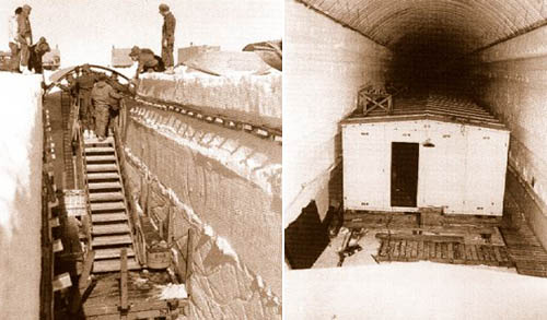
 [Image: Camp Century under construction; photograph via
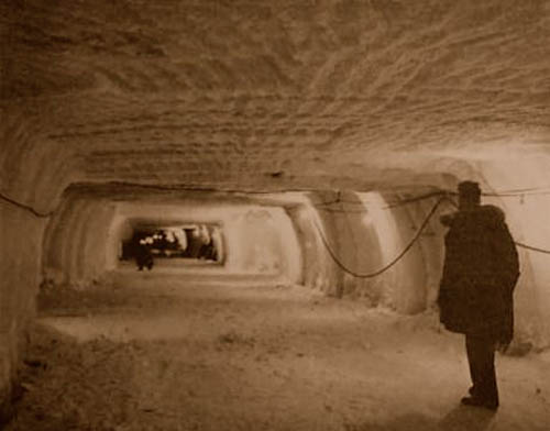
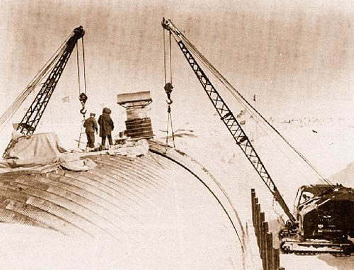
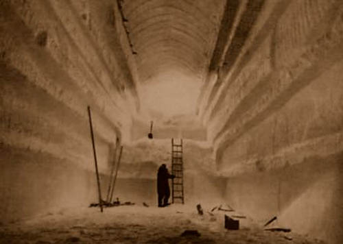 [Images: Camp Century under construction; photographs via
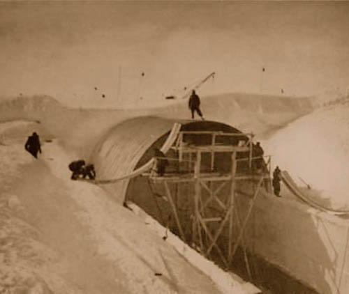
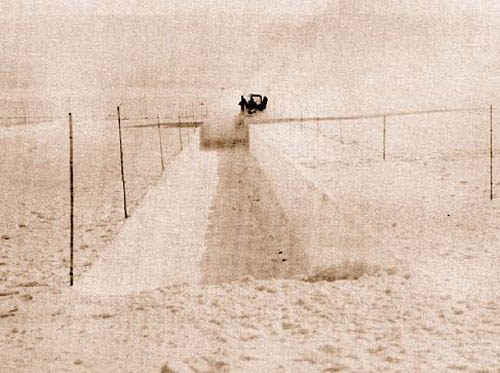
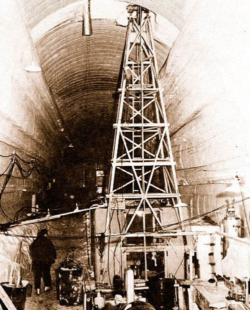 [Images: Camp Century under construction; photographs via
 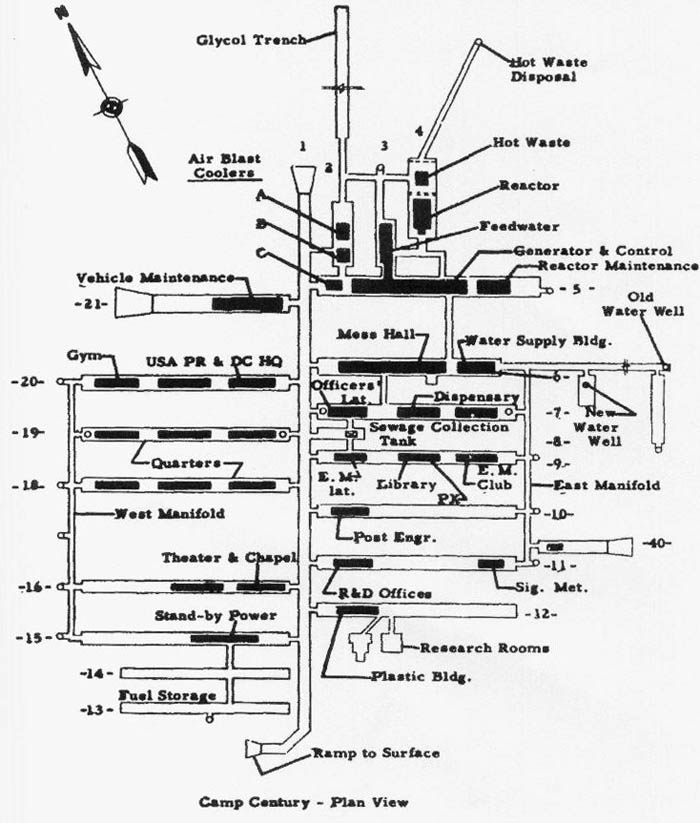 [Image: The plan of Camp Century; via
  [Image: U.S. Army photograph, via the