Metropolitan Accomplice

[Image: Photo by Jonas Roosens/AFP/Getty Images, courtesy of the Guardian].

You might have seen the news that a crew of burglars used sewer tunnels beneath the diamond district in Antwerp, Belgium, to break into a nearby bank vault.

“Detectives in Antwerp are searching for clues in a sewage pipe under the Belgian city’s diamond quarter after burglars apparently crawled through it to break into a bank holding safe deposit boxes full of jewels,” the Guardian reported.

The heist allegedly began across the street, in a separate building, where they dug into the sewer network; one of the city’s many subterranean pipes led close enough to the bank that the crew could then tunnel just a few more meters to make entrance.

A couple of details stand out. For example, the police apparently had to hang back long enough to take gas measurements above the newly opened sewer tunnel, fearing either that the air quality would be so bad that they could risk asphyxiation or that the sewer emanations themselves might be explosive.

Either way, this suggests a possible strategic move by future burglars, who night now know that police—or, at the very least, police not equipped with gas masks—will be delayed due to chemical concerns. Infrastructural off-gassing could become a kind of criminal camouflage.

The other detail is simply that, when the police began investigating the crime, “The first the residents of the central Antwerp district knew of the incident was when police raised all the manhole covers running down the centre of Nerviërsstraat,” the Guardian reported. This otherwise inexplicable sight—law enforcement officers suddenly raising the lid on the city’s underworld—was actually part of a forensic investigation.

I’ve already written at length about tunnel jobs used in bank heists—including a still-unsolved crime from Los Angeles, back in the 1980s—in my book, A Burglar’s Guide to the City, so I will defer to that book in terms of addressing specific aspects of underground crime. In fact, I would perhaps even more specifically recommend the book Flawless by Scott Selby and Greg Campbell, about another, massive heist in Antwerp’s diamond district pulled off in 2003.

[Images: Sewer maps and diagrams are now freely available online; the ones seen here are from Los Angeles and detail the same neighborhood in which a 1986 bank heist occurred, where the bandits tunneled into a vault using the city’s stormwater network. Read more in A Burglar’s Guide to the City or in retired FBI agent Bill Rehder’s absurdly enjoyable memoir, Where The Money Is].

Instead, what seems worth commenting on here is simply the very nature of urban infrastructure and the ease with which it can be repurposed for designing, planning, and committing crimes. The city itself can be an accomplice in acts entirely unrelated to the infrastructure in question. A freeway route enables a bank-heist getaway, a sewer tunnel offers jewel thieves a subterranean method of entry, a specific intersection’s geometric complexity means that carjackings are more likely to occur there: the city is filled with silent accomplices to future criminal activity, activities and events unforeseen by most city planners.

Will this intersection lead to more carjackings? is unlikely to be high on the list of questions posed by community feedback, yet it’s exactly that sort of tactical thinking that might allow designers to stay one step ahead of the criminals who seek to abuse those same designers’ finished projects.

(Thanks to Nicola Twilley for the tip!)

Cities of the Sun

[Image: Ningbo, China, via Google Maps].

Although I’ll leave it up to you to decide if you agree with the author’s critique of planning regulations, there is a fascinating post over at NYU’s Marron Institute. It was originally published back in 2014, but I just saw it the other day thanks to a tweet from Nicola Twilley.

There, Alain Bertaud describes a planning rule from 1950s China: “In the 1950s,” Bertaud writes, “China established a regulation requiring that at least one room in each apartment receive a minimum of one hour of sunshine on the day of the winter solstice, December 21.”

As an architectural constraint, this is actually quite amazing: it needn’t inspire identical towers with identical windows all pointing in the same direction, but could very easily lead to a riot of creativity and innovation, pushing architects to imagine increasingly clever structural and material means for opening even the deepest megastructural interior to winter sunlight.

In a sense, I might say, it is not the regulation’s fault if architects come to the table with a yawning and lackluster response. While this is admittedly an anachronistic comment, given what little I know about city planning in China’s state-driven economy of the 1950s, my larger point is simply that even extreme design constraints can be implemented with subtleness and creativity.

[Image: Guangzhou, China, via Google Maps].

Bertaud continues: “even though the rule no longer applies, its impact on the spatial structure of Chinese cities remains.” This kicks off a kind of forensic examination of Chinese urban form, with the goal of finding the sun of the winter solstice shining somewhere at each city’s regulatory core.

First of all, right away stuff like this is incredible: it is urban-planning analysis as astronomical inquiry, or, more abstractly speaking, it is the suggestion that, hidden somewhere in the fabric of the world we’ve built for ourselves, there are traces of older rules or beliefs that still make their presence known.

This is why things like apotropaic marks are so interesting, for example, not because you have to believe in the occult, but because these marks reveal that even superstition and folklore have spatial effects, and that these beliefs have influenced the design and construction of thresholds and hearths for centuries. Even apparently secular architecture has irrational patterns of belief built into it.

[Image: Beijing, China, via Google Maps].

In any case, the solstice-planning rule “boiled down to a simple mathematical formula: distance d between buildings is determined by the height of building h multiplied by the tangent of the angle α of the sun on the winter solstice at 11:30 in the morning using solar time.” It is “a mathematical formula linked to the movement of the sun,” which, for Bertaud, falsely lent it the air of science, creating the illusion that this approach was rational—in short, that it was a good idea.

One interesting emergent side-effect of the rule, however, is that, by necessity, it had different spatial effects at different latitudes due to the curvature of the Earth. Chinese urban form became a kind of diagram of the Earth’s relationship to the solar system: the distances between buildings, the layouts of rooms inside those buildings, the locations of windows inside those rooms, all taking their cue from a celestial source.

Like a careful study of Stonehenge, you could reverse-engineer the precise location of the sun on a specific day of the year from the layouts of Chinese cities.

But is such poetry really worth it, economically and spatially? Bertaud certainly thinks not. Check out the original post for more.

(The images in this post were arbitrarily taken from Google Maps purely based on locations referred to by Bertaud’s post; they should not be seen as visual evidence of the 1950s planning law discussed here.)

The Remnants

[Image: From An Enduring Wilderness: Toronto’s Natural Parklands by Robert Burley].

Photographer Robert Burley has a new book due out in two weeks called An Enduring Wilderness: Toronto’s Natural Parklands.

[Images: From An Enduring Wilderness: Toronto’s Natural Parklands by Robert Burley].

While it would seem at first to be only of local interest to those living in and around Toronto, the photos themselves are gorgeous and the conditions they document are nearly universal for other North American cities: scenes of natural, remnant ecosystems butting up against, but nonetheless resisting, the brute force of urban development.

[Image: From An Enduring Wilderness: Toronto’s Natural Parklands by Robert Burley].

As Burley explains, many of the parks depicted are informal—that is, they are undesigned—and almost all of them follow old creeks and ravines that meander through the ancestral terrain. (This, as you might recall, is also the premise for much of Michael Cook’s work, who has been tracking those same waterways in their Stygian journey underground.)

[Images: From An Enduring Wilderness: Toronto’s Natural Parklands by Robert Burley].

However, Burley warns, “these ravine systems are in danger of being loved to death by city dwellers desperate for green space.” From the book:

Toronto has one of the largest urban park systems in the world, and yet it is unknown to most, including many of the city’s three million inhabitants. This extensive ravine network of sunken rivers, forested vales, and an expansive shoreline has historically been overlooked, neglected, or forgotten, but in recent years these unique wild spaces have been rediscovered by a growing population embracing nature inside the city limits. The parklands were not designed or constructed for a greater public good but rather are landscape remnants of pre-settlement times that have stubbornly refused to conform to urban development.

The book comes out later this month, and a number of events are planned in Toronto over the coming week, including an exhibition of Burley’s work from the book; more info is available at the John B. Aird Gallery.

Directions Might Not Terminate

Katherine Ye has posted short descriptions of “twenty tiny cities,” an homage to Italo Calvino, and some of them are so good. Clockwork City: “Buildings are constantly sliding, turning, merging, separating. Directions: ‘Your destination will arrive in 1.5 hours.’” Fractal City: “Directions are given recursively. ‘Go to the middle triangle, then to its top triangle. Repeat until you arrive.’ Directions might not terminate.” Desire Path City: “They covered the city with meadows of grass, then after a year, built roads where foot traffic had worn grass to dirt.” Nondeterministic City: “Every time you reach an intersection, you take all of them at once. There are few maps of the city, because you’ll always find what you’re looking for.” (Spotted via @katierosepipkin).

Under the Bridge

Photographer Gisela Erlacher has been documenting “the spaces found hidden underneath highways and flyovers across Europe and China,” as seen in the many photos posted over at Creative Boom. “Each photograph reveals not only her own fascination with these massive concrete monstrosities, but also her interest in how they’re now being used by the people who choose to wedge themselves into these forgotten areas.”

The Electromagnetic Fortification of the Suburbs

[Image: A drone from DJI].

It’s hardly surprising to read that drones can be repurposed as burglars’ tools; at this point, take any activity, add a drone, and you, too, can have a news story (or Kickstarter) dedicated to the result.

“Why not send an inexpensive drone, snoop in your windows, see if you have any pets, see if you have any expensive electronics, maybe find out if you have any jewelry hanging around,” a security expert wonders aloud to Hawaii’s KITV, describing what he sees as the future of burglary. Burglars “can do all that with a drone without ever stepping a foot on your property line.”

“So what’s a homeowner to do?” the TV station asks.

They suggest following the drone back to its owner, who, due both to battery life and signal range, will be nearby; or even installing “new expensive high-tech drone detection systems that claim to detect the sounds of a drone’s propellers.” This is absurd—suggesting that some sort of drone alarm will go off at 3am, driving you out of bed—but it’s such a perfectly surreal vision of the suburbs of tomorrow.

Fortifying our homes against drone incursion will be the next bull market in security: whole subdivisions designed to thwart drone flights, marketed to potential homeowners specifically for that very reason.

You go home for the weekend to visit your parents where, rather than being enlisted to mow the lawn or clean the gutters, you’re sent you out on drone duty, installing perimeter defenses or some sort of jamming blanket, an electromagnetically-active geotextile disguised beneath the mulch. Complex nets and spiderweb-like antennas go on sale at Home Depot, perfect for snaring drone rotors and leading to an explosion in suburban bird deaths.

[Image: A drone from DJI].

This news comes simultaneously with a story in Forbes, where we read that drone manufacturer DJI is implementing a GPS block on its products: they will no longer be able to fly within 15.5 miles of the White House.

The company is issuing “a mandatory firmware update to all Phantom drones that will restrict flight within a 15.5 mile radius centered around downtown Washington D.C. Pilots looking to operate their Phantom drone will not be able to take off or fly within the no-fly-zone.”

Based off a drone’s GPS coordinates, the technology to geo-fence drones from entering a particular airspace, especially around major airports, has been around in Phantoms since early last year. The new update will add more airports to its no-fly-zone database as the 709 no-fly-zones already in the Phantom’s flight controller software will expand to more than 10,000, with additional restrictions added to prevent flight across national borders.

This is remarkable for a number of reasons, not the least of which is the fact that firmware updates and geography now work together to disable entire classes of products within a given zone or GPS range. Put another way, drones today—but what tomorrow?

Geofencing or “locationized” firearms have already been discussed as a possible future form of gun control, for example, and it would not be at all surprising to see “locationized” smartphones or geofenced cameras becoming a thing in the next few years.

All a government (or criminal syndicate) would have to do is release a (malicious) firmware update, temporarily shutting down certain types of electronics within range of, say, a presidential inauguration (or a bank heist).

[Image: A drone from DJI].

More to the point of this post, however, GPS-based geofencing will also become part of the electromagnetic armature of future residential developments, a new, invisible layer of security for those who are willing to pay for it.

Think, for example, of the extraordinary geographic dazzle effects used by government buildings to camouflage their real-world locations: as Dana Priest and William Arkin wrote for The Washington Post back in 2012, “most people don’t realize when they’re nearing the epicenter of Fort Meade’s, even when the GPS on their car dashboard suddenly begins giving incorrect directions, trapping the driver in a series of U-turns, because the government is jamming all nearby signals.”

If half the point of living in the suburbs is to obtain a certain level of privacy, personal safety, and peace of mind, then it is hardly science fiction to suggest that the electromagnetic fortification of suburbia is on the immediate horizon.

You won’t just turn on a burglar alarm with your handy smartphone app; you’ll also switch on signal-jamming networks hidden in the trees or a location-scrambling geofence camouflaged as a garden gnome at the edge of your well-mown lawn. Drones, dazzled by invisible waves of unpredictable geographic information, will perform U-turns or sudden dives, even racing off to a pre-ordained security cage where they can be pulled from the air and disabled.

The truly high-end residential developments of tomorrow will be electromagnetically fortified, impervious to drones, and, unless you’ve been invited there, impossible for your cars and cellphones even to find.

Weather is the Future of Urban Design

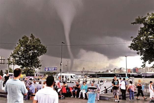
[Image: From a newscast about Istanbul’s recent tornadoes].

It’s hard to resist a story where urban design is blamed for creating tornadoes. But the recent cluster of “freak mini-tornadoes” striking Istanbul offers an anomaly in search of an explanation, and the newly built outer edges of the metropolis are potentially to blame.

According to Ed Danaher at NOAA’s Center for Weather and Climate Prediction, speaking to the Hürriyet Daily News, “we know that tornadoes are exotic to Istanbul, like snow is to Florida.” That article go on to suggest, however, that these tornadoes “are possibly one result of the city’s rapid urbanization,” and that such a claim can be made based on their conversations with other meteorological researchers working at NOAA.

As their headline states bluntly, “Istanbul tornadoes [are] a ‘result of urbanization’.”

This conjures up frankly outrageous images of a city so sprawling—and so thermally ill-conceived—that huge masses of air at different temperatures are now rising into the sky to do battle, violently colliding like mythological titans above the city to generate the surreal tornadoes now ripping through the neighborhoods below.

Weather might be the future of urban design—but the rest of the news story actually includes no such quotations or any relevant evidence that would back up such a claim. They refer to climate change and its effects on regional humidity, of course, but, oddly enough, there is otherwise no attempt to back up the opening statement.

[Image: Photographer uncredited; via the Hürriyet Daily News].

But… But… It’s so tempting to speculate. Beyond just being clickbait, this vision of suburban sprawl inadvertently churning the skies with the introduced turbulence of tornadoes, and thus destroying the landscape like some twisted instant karma of the atmosphere, is too awesome not to entertain for at least the length of a cup of coffee.

What weird old gods of weather have Istanbul’s architects accidentally awoken? As streets and buildings continue to bulge outward into the forests and hills of the region, what else might their spatial activities unleash?

(Originally spotted via @urbanphoto_blog. Vaguely related: The Weather Bowl).

Calling All Agents

Here are some opportunities for writers, designers, and filmmakers, in case you’re looking for ways to challenge yourself over the summer.

[Image: “Angels” (2006) by Ruairi Glynn, one of the co-organizers of Stories of Change].

1) Arup Foresight and the Bartlett School of Architecture have teamed up to gather what they call “responses to some of the world’s most pressing issues as featured in the publication, Drivers of Change. We would like you to tell us your Stories of Change.” Original films, texts, and architectural designs are all eligible and welcome; the texts could even “be a poem, a letter, a blog-post, even a currated collection of tweets.” Which is good news, but the deadline is approaching quickly: Friday, 24 June 2011. See the Stories of Change website for more.

2) For its new call for papers, the Bauhaus-Universität’s Horizonte journal begins by quoting architect Raimund Abraham: “From earliest times,” Abraham writes, “architecture has complied with that order of logical forms which is contained in the nature of each material. That is to say: each material can only be used within the limits imposed by its organic and technical possibilities.” This fourth issue of the consistently well-designed journal explores the materiality of building: the issue thus “challenges the constraints and possibilities of architectural production, in order to reflect on the material and constructive methodologies of the present day.” I imagine essays and even speculative fiction covering everything from genetically engineered building materials to 3D printers—to new types of brick to artisanal craftwork—would be of interest. Your deadline is 8 July 2011.

3) The Architectural League wants to give New York the Greatest Grid:

On the occasion of the two hundredth anniversary of the 1811 Commissioners’ Plan for New York, the foundational document that established the Manhattan street plan from Houston Street to 155th Street, the Architectural League invites architects, landscape architects, urban designers, and other design professionals to use the Manhattan street grid as a catalyst for thinking about the present and future of New York. For two centuries, the Manhattan street grid has demonstrated an astonishing flexibility to accommodate the architectural gestures and urban planning theories of successive generations of architects, urban designers, private developers, and city officials. Given its capacity for reinvention, how might the Manhattan grid continue to adapt and respond to the challenges and opportunities—both large and small—that New York faces now and into the future?

Your deadline is 26 September 2011; see the competition website for much more information.

4) A new Advanced Architecture Contest has been announced, sponsored by the Institute for Advanced Architecture and Hewlett Packard. The theme this year is “CITY-SENSE: Shaping our environment with real-time data.” Aim to submit “a proposal capable of responding to emerging challenges in areas such as ecology, information technology, architecture, and urban planning, with the purpose of balancing the impact real-time data collection might have on sensor-driven cities.” Read more at the Advanced Architecture Contest website; the deadline is 26 September 2011.

5) The California Architectural Foundation, in partnership with the Arid Lands Institute and the Academy for Emerging Professionals, has launched what it calls “an open ideas competition for retrofitting the American West.” The Drylands Competition seeks new ways of “anticipating, mitigating, and adapting to projected impacts of climate change” and other “critical challenges” facing the region. These challenges include water scarcity, obsolete infrastructure, and even the growing gap between scientific knowledge and public policy. “Design teams are invited to generate progressive proposals that suggest to policy makers and the public creative alternatives for the American west, ideas that may be replicated throughout the world.” Register by 15 November 2011; see their website for much more info.

6) Meanwhile, across the pond, the Architects Journal is seeking essays of up to 1,500 words, by writers under the age of 35, for their £1,000 AJ Writing Prize (the money will be split amongst all winners). The jury consists of Christine Murray, Alan Berman, Joseph Rykwert, and Mary Banham; you only have until 30 June 2011 to participate, so get cracking.

7) Finally, this one doesn’t open till September 2011, but it sounds fascinating. Sponsored by Architecture for Humanity, [un]restricted access is “a design competition that will re-envision the future of decommissioned military space. This is an open invite to the global design and construction community to identify retired military installations in their own backyard, to collaborate with local stakeholders, and to reclaim these spaces for social, economic, and environmental good.” As I say, thought, it doesn’t launch until September, but keep your eyes on the [un]restricted access website for emerging info.

Zone for Cloud

[Image: Detail of a zoning map for New York City].

Earlier this month, mammoth – just two months old, but already one of the more interesting architecture blogs out there – cited climatological research that certain land use patterns can dramatically affect the formation of clouds above.

In other words, pastures, forests, suburbs, cities, farms, and so on, all affect the skies in very particular spatial ways. Deforestation, for instance, has “substantially altered cloud patterns” in the Amazon; specifically, we read that “patches of trees behave as ‘green oceans’ while cleared pastures act like ‘continents’,” generating a new marbling of the local atmosphere.

The same thing can be found to happen above cities, of course. Instead of “being zoned ‘R-3 Residential Low Density’,” mammoth continued, “a block might be zoned ‘Cumulus H-2’.” Or Mammatus H-3. In this tongue-in-cheek vision of sky-centric urban development, all new buildings would have to be cleared with a Meteorological Bureau to ensure that they produce the right types of cloud. Atmospheric retrofitting comes to mean attaching bizarre cantilevers, ramps, and platforms to the roofs and walls of existing houses till the clouds above look just right.

Sky vandals are people who deliberately misengineer the weather through the use of inappropriate roof ornamentation.

Over generations, you and your friends and the descendants of your friends sculpt vast, urban-scale volumes of air, guiding seasonal rain events toward certain building types – where, as mammoth‘s own earlier paper about fog farming suggests, “fog nets” might capture a new water source for the city.

(Incidentally, there is a short vignette in The BLDGBLOG Book about bespoke, privatized, and extremely local weather control).

The Weather Bowl

[Image: A passing Illinois lightning storm and supercell, the clouds peeling away to reveal evening stars; photo ©Extreme Instability/Mike Hollingshead. If you can overlook pet photos, meanwhile, don’t miss Hollingshead’s other storm work from 2006 and 2005 – including these Nebraskan auroras. While you’re at it, this storm sequence has some stunning, pre-storm landscape shots].

During a disastrously moderated talk at the MAK Center last night in West Hollywood, where the panelists could hardly get a word in edgewise because of the barely coherent, self-answering, 40-minute monologue of the moderator, Karl Chu briefly managed to say that he was interested in constructing and designing whole continents and weather systems.

Which got me thinking.

Given time, some digging equipment, a bit of geotechnical expertise, and loads of money, for instance, you could turn the entirety of greater Los Angeles into a weather bowl, dedicated to the recreation of famous storms. Install some rotating fans and open-air wind tunnels, build some deflection screens in the Hollywood Hills, scatter smaller fans and blowers throughout Culver City or overlooking Burbank, amplify the natural sea winds blowing in through Long Beach – and you could re-enact famous weather systems of the 18th and 19th centuries, reproducing hurricanes, even bringing back, for one night, the notorious storm that killed Shelley.

You consult your table of weather histories, choose your storm and go: fans deep in hillsides start turning, the wind tunnels roar, and lo! The exact speed and direction of Hurricane Andrew is unleashed. Seed the clouds a bit and reprogram the fans, and you can precisely reproduce the atmospheric conditions from the night William Blake was born. Or the ice storm that leveled electrical gantries outside Montreal, now whirling in a snow-blurred haze through Echo Park.

You could build competing weather colosseums in London, San Francisco, Tokyo, and Beijing. Every night new storms are reenacted, moving upward in scale and complexity. The storm Goethe saw as a nineteen year-old, contemplating European history, kills a family of seven outside Nanking. You soon get Weather Olympics, or a new Pritzker Prize for Best Weather Effects.

One day, a man consumed with nostalgia hacks the control program to recreate the exact breeze on which he once flew a kite over the Monbijouplatz in Berlin…

(For more on the exhibition now up at the MAK Center, download this PDF).