The origin of the television set was heavily shrouded in both spiritualism and the occult, Stefan Andriopoulos writes in his new book Ghostly Apparitions. In fact, as its very name implies, the television was first conceived as a technical device for seeing at a distance: like the telephone (speaking at a distance) and telescope (viewing at a distance), the television was intended as an almost magical box through which we could watch distant events unfold, a kind of technological crystal ball.
Andriopoulos’s book puts the TV into a long line of other “optical media” that go back at least as far as popular Renaissance experiments involving technologically-induced illusions, such as concave mirrors, magic lanterns, disorienting walls of smoke, and other “ghostly apparitions” and “phantasmagoric projections” created by specialty devices. These were conjuring tricks, sure—mere public spectacles, so to speak—but successfully achieving them required sophisticated understandings of basic physical factors such as light, shadow, and acoustics, making an audience see—and, most importantly, believe in—the illusion.
A Magic Lantern for Watching Events at a Distance
What’s central to Andriopoulos’s argument is that these devices incorporated earlier experimental instruments devised specifically for pursuing supernatural research—for visualizing the invisible and showing the subtle forces at work in everyday life. In his words, these were “devices developed in occult research”—including explicitly “televisionlike devices”—that had been invented in the name of spiritualism toward the end of the 19th century and that, only a decade or two later, “played a constitutive role in the emergence of radio and television.”
[Image: From Etienne-Gaspard Robertson’s 1834 study of technical phantasmagoria, via Ghostly Apparitions].
In Andriopoulos’s words, this was simply part of “the reciprocal interaction between occultism and the natural sciences that characterized the cultural construction of new technological media in the late nineteenth century,” a “two-directional exchange between occultism and technology.” New forms of broadcast technology and belief in the occult? No big deal.
So, while the television itself—the object you and I most likely know as the utterly mundane fixture of family distraction sitting centrally ensconced in a nearby living room—might not be a supernatural mechanism, it nonetheless descends from a strange and convoluted line of esoteric experimentation, including early attempts at controlling electromagnetic transmissions, directing radio waves, and even experiencing various forms of so-called “remote viewing.”
The idea of a medium takes on a double meaning here, Andriopoulos explains, as the word refers both to the media—in the sense of a professional world of publishing and transmission—and to the medium, in the sense of a specific, vaguely shamanic person who acts as a psychic or seer. The medium thus acts as an intermediary between humans and the supernatural world in a very literal sense.
Indeed, in Andriopoulos’s version of television’s origin story, the notion of spiritual clairvoyance was very much part of the overall intention of the device.
Clairvoyance—a word that literally means clear vision, yet that has now come to refer almost exclusively to a supernatural ability to see things at a distance or before events even happen—offered an easy metaphor for this new mechanism.
Television promised clairvoyance in the sense that a TV could allow seeing without interference or noise. It would give viewers a way to tune into and clearly see a broadcast’s invisible signals—with the implication that an esoteric remote-viewing apparatus with forgotten supernatural intentions is now mounted and enshrined in nearly everyone’s home.
[Image: A “moving face” transmitted by John Logie Baird at a public demonstration of TV in 1926 (photo via the BBC)].
I’ll leave it to curious readers to look for Andriopoulos’s book itself—with the caveat that it is quite heavy on German idealism and rather light on real tech history—but it is worth mentioning the fact that at least one other technical aspect of the 20th-century television also followed a very bizarre historical trajectory.
Part Tomb, Part Church, Part Planetarium
The cathode ray—a vacuum tube technology found in early television sets—took on an unexpected and extraordinary use in the work of gonzo Norwegian inventor Kristian Birkeland. Birkeland used cathode rays in his attempt to build a doomed scale model of the solar system.
I genuinely love this story and I have written about it elsewhere, including both here on BLDGBLOG and in The BLDGBLOG Book, but it’s well worth retelling.
In a nutshell, Birkeland was the first scientist to correctly hypothesize the origins of the Northern Lights, rightly deducing from his own research into electromagnetic phenomena that the aurora borealis was actually caused by interactions between charged particles constantly streaming toward earth from the sun and the earth’s own protective magnetic field. This produced the extraordinary displays of light Birkeland had seen in the planet’s far north.
However, as Birkeland fell deeper into an eventually fatal addiction to extreme levels of caffeine and a slow-acting hypnotic drug called Veronal, he also—awesomely—became fixated on the weirdly impossible goal of precisely modeling the Northern Lights in miniature. He sought to build a kind of Bay Model of the Northern Lights.
[Image: Kristian Birkeland stares deeply into his universal simulator (via)].
As author Lucy Jago tells Birkeland’s amazing story in her book The Northern Lights, he was intent on producing a kind of astronomical television set: a “televisionlike device,” in Andriopoulos’s words, whose inner technical workings would not just broadcast actions and characters seen elsewhere, but would actually model the electromagnetic secrets of the universe.
As Jago describes his project, Birkeland “drew up plans for a new machine unlike anything that had been made before.” It resembled “a spacious aquarium,” she writes, a shining box that would act as “a window into space.”
The box would be pumped out to create a vacuum and he would use larger globes and a more powerful cathode to produce charged particles. With so much more room he would be able to see effects, obscured in the smaller tubes, that could take his Northern Lights theory one step further–into a complete cosmogony, a theory of the origins of the universe.
It was a multifaceted and extraordinary undertaking. With it, Jago points out, “Birkeland was able to simulate Saturn’s rings, comet tails, and the Zodiacal Light. He even experimented with space propulsion using cathode rays. Sophisticated photographs were taken of each simulation, to be included in the next volume of Birkeland’s great work, which would discern the electromagnetic nature of the universe and his theories about the formation of the solar system.”
However, this “spacious aquarium” was by no means the end of Birkeland’s manic (tele)vision.
[Image: From Birkeland’s The Norwegian Aurora Polaris Expedition 1902-1903, Vol. 1: On the Cause of Magnetic Storms and The Origin of Terrestrial Magnetism (via)].
His ultimate goal—devised while near-death in a hotel room in Egypt—was to construct a vacuum chamber partially excavated into the solid rock of a mountain peak, an insane mixture of tomb, church, and planetarium.
The resulting cathedral-like space—think of it as a three-dimensionally immersive, landscape-scale television set carved directly into bedrock—would thus be an artificial cavern inside of which flickering electric mirages of stars, planets, comets, and aurorae would spiral and glow for a hypnotized audience.
Birkeland wrote about this astonishing plan in a letter to a friend. He was clearly excited about what he called a “great idea I have had.” It would be—and the emphasis is all Birkeland’s—”a museum for the discovery of the Earth’s magnetism, magnetic storms, the nature of sunspots, of planets—their nature and creation.”
His excitement was justified, and the ensuing description is worth quoting at length; you can almost feel the caffeine. “On a little hill,” he scribbled, presumably on his Egyptian hotel’s own stationery, perhaps even featuring a little image of the pyramids embossed in its letterhead, reminding him of the ambitions of long-dead pharaohs, “I will build a dome of granite, the walls will be a meter thick, the floor will be formed of the mountain itself and the top of the dome, fourteen meters in diameter, will be a gilded copper sphere. Can you guess what the dome will cover? When I’m boasting I say to my friends here ‘next to God, I have the greatest vacuum chamber in the world.’ I will make a vacuum chamber of 1,000 cubic metres and, every Sunday, people will have the opportunity to see a ring of Saturn ten metres in diameter, sunspots like no one else can do better, Zodiacal Light as evocative as the natural one and, finally, auroras… four meters in diametre. The same sphere will serve as Saturn, the sun, and Earth, and will be driven round by a motor.”
Every Sunday, as if attending Mass, congregants of this artificial solar system would thus hike up some remote mountain trail, heading deep into the cavernous and immersive television of Birkeland’s own astronomy, hypnotized by the explosive whirls of its peculiar, peacock-like displays of electromagnetism, shimmering cathedrals of artificially controlled planetary light.
Seen in the context of the occult mechanisms, psychic TVs, and clairvoyant media technologies of Stefan Andriopoulos’s book, Birkeland’s story reveals just one particularly monumental take on the other-worldly possibilities implied by televisual media, bypassing the supernatural altogether to focus on something altogether more extreme: a direct visual engagement with nature itself, in all its blazing detail.
Of course, Birkeland’s cathode ray model of the solar system might not have conjured ghosts or visualized the spiritual energies that Andriopoulous explores in his book, but it did try to bring the heavens down to earth in the form of a 1,000 cubic meter television set partially hewn from mountain granite.
It was the most awesome TV ever attempted, a doomed and never-realized invention that nonetheless puts all of today’s visual media to shame.
(An earlier version of this post previously appeared on Gizmodo).
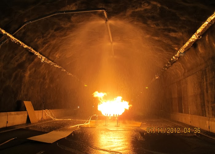
The abandoned Runehamar road tunnel on the southwest coast of Norway has been redesigned and given new life as a site for the experimental burning of trucks, cargo, and other vehicular structures in order to learn how subterranean road fires can best be extinguished.
It’s a kind of Nordic funeral pyre built not for the bodies of kings but for the products of the automotive industry, an underground bonfire of simulated car wrecks that seems more like something you’d see in the fiction of J.G. Ballard.
The overall structure has been modified to serve as a closely-controlled thermal environment—more a furnace than a piece of transportation infrastructure—complete with an array of instruments and sensors, and a system of sprinklers and ventilation fans that let observers try out novel methods of fire suppression.
In a sense, this is what might happen if someone like architect Philippe Rahm was given a limited budget and hired to design experimental subterranean road infrastructure, with his work’s focus on the thermal behavior of spaces and other non-visual dimensions of the built environment.
There is a need for more detailed knowledge on how and why various semi-trailer cargos burn so strongly and why they spread so quickly. The high heat exposure from the semi-trailers to the tunnel linings also needs more focus. The only reasonable way of finding an answer to these questions is to carry out systematic large scale experiments that can provide a better basis for the design of technical systems in road tunnels.
There’s more to write about the tunnel, I’m sure, and there is a bit more detail in the original post on Gizmodo—including, for those of you curious, this PDF that comes complete with structural and thermal diagrams of the burning apparatus.
But I suppose I’m more interested in the sheer strangeness of an old road tunnel being transformed into a venue for controlled thermal events. It is ritualistic, repetitive, and pyromaniacal, as if vitamin-D-deprived engineers in lab coats have been endlessly sacrificing sacred cargo for some infernal mountain, an altar for automotive transubstantiation, where unknown driving objects are reduced to ash and studied, again and again, filmed and re-watched—until the next fire, when the sprinklers fill up again and the vents, like a buried engine, begin to roar.
Fort Irwin is a U.S. army base nearly the size of Rhode Island, located in the Mojave Desert about an hour’s drive northeast of Barstow, California. There you will find the National Training Center, or NTC, at which all U.S. troops, from all services, spend a twenty-one day rotation before they deploy overseas.
Coincidentally, as we explored the Painted Rocks located just outside the gate while waiting for the tour to start, an old acquaintance from Los Angeles—architect and geographer Rick Miller—pulled up in his Prius, also early for the same tour.
We laughed, said hello, and caught up about a class Rick had been teaching at UCLA about the military defense of L.A. during World War II, through to the present. An artificial battlefield, beyond even the furthest fringes of Los Angeles, Fort Irwin thus seemed like an appropriate place to meet.
We were soon joined by a small group of other visitors—consisting, for the most part, of family members of soldiers deployed on the base, as well as two architecture students from Montréal—before a large white tour bus rolled up across the gravel.
Renita, a former combat videographer who now handles public affairs at Fort Irwin, took our names, IDs, and signatures for reasons of liability (we would be seeing live explosions and simulated gunfire, and there was always the risk that someone might get hurt).
The day began with a glimpse into the economics and culture of how a nation prepares its soldiers for war; an orientation, of sorts, before we headed out to visit one of fifteen artificial cities scattered throughout the base.
In the plush lecture hall used for “After Action Reviews”—and thus, Renita apologized, air-conditioned to a morgue-like chill in order to keep soldiers awake as their adrenalin levels crash—we received a briefing from the base’s commander, Brigadier General Terry Ferrell.
With pride, Ferrell noted that Fort Irwin is the only place where the U.S. military can train using all of the systems it will later use in theater. The base’s 1,000 square miles of desert is large enough to allow what Ferrell called “great maneuverability”; its airspace is restricted; and its truly remote location ensures an uncluttered electromagnetic spectrum, meaning that troops can practice both collection and jamming. These latter techniques even include interfering with GPS, providing they warn the Federal Aviation Administration in advance.
Oddly, it’s worth noting that Fort Irwin also houses the electromagnetically sensitive Goldstone Deep Space Communications Complex, part of NASA’s global Deep Space Network. As science writer Oliver Morton explains in a paper called “Moonshine and Glue: A Thirteen-Unit Guide to the Extreme Edge of Astrophysics” (PDF), “when digitized battalions slug it out with all the tools of modern warfare, radio, radar, and electronic warfare emissions fly as freely around Fort Irwin as bullets in a battle. For people listening to signals from distant spacecraft on pre-arranged frequency bands, this noise is not too much of a problem.” However, he adds, for other, far more sensitive experiments, “radio interference from the military next door is its biggest headache.”
Unusually for the American West, where mineral rights are often transferred separately, the military also owns the ground beneath Fort Irwin, which means that they have carved out an extensive network of tunnels and caves from which to flush pretend insurgents.
This 120-person strong insurgent troop is drawn from the base’s own Blackhorse Regiment, a division of the U.S. Army that exists solely to provide opposition. Whatever the war, the 11th Armored is always the pretend enemy. According to Ferrell, their current role as Afghan rebels is widely envied: they receive specialized training (for example, in building IEDs) and are held to “reduced grooming standards,” while their mission is simply to “stay alive and wreak havoc.”
If they die during a NTC simulation, they have to shave and go back on detail on the base, Ferrell added, so the incentive to evade their American opponents is strong.
In addition to the in-house enemy regiment, there is an entire 2,200-person logistics corps dedicated to rotating units in and out of Fort Irwin and equipping them for training. Every ordnance the United States military has, with the exception of biological and chemical weapons, is used during NTC simulations, Ferrell told us. What’s more, in the interests of realism (and expense be damned), troops train using their own equipment, which means that bringing in, for example, the 10th Mountain Division (on rotation during our visit), also means transporting their tanks and helicopters from their home base at Fort Drum, New York, to California, and back again.
Units are deployed to Fort Irwin for twenty-one days, fourteen of which are spent in what Fort Irwin refers to as “The Box” (as in “sandbox”). This is the vast desert training area that includes fifteen simulated towns and the previously mentioned tunnel and caves, as well as expansive gunnery ranges and tank battle arenas.
Following our briefing, we headed out to the largest mock village in the complex, the Afghan town of Ertebat Shar, originally known, during its Iraqi incarnation, as Medina Wasl. Before we re-boarded the bus, Renita issued a stern warning: “‘Afghanistan’ is not modernized with plumbing. There are Porta-Johns, but I wanted to let you know the situation before we roll out there.”
A twenty-minute drive later, through relatively featureless desert, our visit to “Afghanistan” began with a casual walk down the main street, where we were greeted by actors trying to sell us plastic loaves of bread and piles of fake meat. Fort Irwin employs more than 350 civilian role-players, many of whom are of Middle Eastern origin, although Ferrell explained that they are still trying to recruit more Afghans, in order “to provide the texture of the culture.”
The atmosphere is strangely good-natured, which was at least partially amplified by a feeling of mild embarrassment, as the rules of engagement, so to speak, are not immediately clear; you, the visitor, are obviously aware of the fact that these people are paid actors, but it feels distinctly odd to slip into character yourself and pretend that you might want to buy some bread.
In fact, it’s impossible not to wonder how peculiar it must be for a refugee, or even a second-generation immigrant, from Iraq or Afghanistan, to pretend to be a baker in a simulated “native” village on a military base in the California desert, only to see tourists in shorts and sunglasses walking through, smiling uncomfortably and taking photos with their phones before strolling away without saying anything.
Even more peculiarly, as we reached the end of the street, the market—and all the actors in it—vanished behind us, dispersing back into the fake city, as if only called into being by our presence.
By now, with the opening act over, we were stopped in front of the town’s “Lyndon Marcus International Hotel” to take stock of our surroundings. In his earlier briefing, Ferrell had described the simulated villages’ close attention to detail—apparently, the footprint for the village came from actual satellite imagery of Baghdad, in order to accurately recreate street widths, and the step sizes inside buildings are Iraqi, rather than U.S., standard.
Dimensions notwithstanding, however, this is a city of cargo containers, their Orientalized facades slapped up and plastered on like make-up. Seen from above, the wooden frames of the illusion become visible and it becomes more and more clear that you are on a film set, an immersive theater of war.
This kind of test village has a long history in U.S. war planning. As journalist Tom Vanderbilt writes in his book Survival City, “In March 1943, with bombing attacks on cities being intensified by all sides, the U.S. Army Corps of Engineers began construction at Dugway [Utah] on a series of ‘enemy villages,’ detailed reproductions of the typical housing found in the industrial districts of cities in Germany and Japan.”
The point of the villages at Dugway, however, was not to train soldiers in urban warfare—with, for instance, simulated street battles or house-to-house clearances —but simply to test the burn capacity of the structures themselves. What sorts of explosives should the U.S. use? How much damage would result? The attention to architectural detail was simply a subset of this larger, more violent inquiry. As Vanderbilt explains, bombs at Dugway “were tested as to their effectiveness against architecture: How well the bombs penetrated the roofs of buildings (without penetrating too far), where they lodged in the building, and the intensity of the resulting fire.”
During the Cold War, combat moved away from urban settings, and Fort Irwin’s desert sandbox became the stage for massive set-piece tank battles against the “Soviet” Blackhorse Cavalry. But, in 1993, following the embarrassment of the Black Hawk Down incident in Mogadishu, Fort Irwin hosted its first urban warfare, or MOUT (Military Operations on Urbanized Terrain) exercise. This response was part of a growing realization shared amongst the armed forces, national security experts, and military contractors that future wars would again take the city as their battlefield.
Massed, professional, and essentially symmetrical armies no longer confront one another on the broad forests and plains of central Europe, the new tactical thinking goes; instead, undeclared combatants living beside—sometimes even with—families in stacked apartment blocks or tight-knit courtyards send out the occasional missile, bullet, or improvised explosive device from a logistically confusing tangle of streets, and “war” becomes the spatial process of determining how to respond.
At Fort Irwin, mock villages began to pop up in the desert. They started out as “sheds bought from Shed World,” Ferrell told us, before being replaced by shipping containers, which, in turn, have been enhanced with stone siding, mosque domes, awnings, and street signs, and, in some cases, even with internal staircases and furniture, too. Indeed, Ertebat Shar/Medina Wasl began its simulated existence in 2007, with just thirteen buildings, but has since expanded to include more than two hundred structures.
The point of these architectural reproductions is no longer, as in the World War II test villages of Dugway, to find better or more efficient methods of architectural destruction; instead, these ersatz buildings and villages are used to equip troops to better navigate the complexity of urban structures—both physical, and, perhaps most importantly, socio-cultural.
In other words, at the most basic level, soldiers will use Fort Irwin’s facsimile villages to practice clearing structures and navigating unmapped, roofed alleyways through cities without clear satellite communications links. However, at least in the training activities accessible to public visitors, the architecture is primarily a stage set for the theater of human relations: a backdrop for meeting and befriending locals (again, paid actors), controlling crowds (actors), rescuing casualties (Fort Irwin’s roster of eight amputees are its most highly paid actors, we learned, in recompense for being literally dragged around during simulated combat operations), and, ultimately, locating and eliminating the bad guys (the Blackhorse regiment).
In the series of set-piece training exercises that take place within the village, the action is coordinated from above by a ring of walkie-talkie connected scenographers, including an extensive internal media presence, who film all of the simulations for later replay in combat analysis. The sense of being on an elaborate, extremely detailed film set is here made explicit. In fact, visitors are openly encouraged to participate in this mediation of the events: we were repeatedly urged to take as many photographs as possible and to share the resulting images on Facebook, Twitter, and more.
Appropriately equipped with ear plugs and eye protection, we filed upstairs to a veranda overlooking one of the village’s main throughways, where we joined the “Observer Coaches” and film crew, taking our positions for the afternoon’s scripted exercise.
Loud explosions, smoke, and fairly grisly combat scenes ensued—and thus, despite their simulated nature, involving Hollywood-style prosthetics and fake blood, please be warned that many of the forthcoming photos could still be quite upsetting for some viewers.
The afternoon’s action began quietly enough, with an American soldier on patrol waving off a man trying to sell him a melon. Suddenly, a truck bomb detonated, smoke filled the air, and an injured woman began to wail, while a soldier slumped against a wall, applying a tourniquet to his own severed arm.
In the subsequent chaos, it was hard to tell who was doing what, and why: gun trucks began rolling down the streets, dodging a live goat and letting off round after round as insurgents fired RPGs (mounted on invisible fishing line that blended in with the electrical wires above our heads) from upstairs windows; blood-covered casualties were loaded into an ambulance while soldiers went door-to-door with their weapons drawn; and, in the episode’s climax, a suicide bomber blew himself up directly beneath us, showering our tour group with ashes.
Twenty minutes later, it was all over. The smoke died down; the actors reassembled, uninjured, to discuss what just occurred; and the sound of blank rounds being fired off behind the buildings at the end of the exercise echoed through the streets.
Incredibly, blank rounds assigned to a particular exercise must be used during that exercise and cannot be saved for another day; if you are curious as to where your tax dollars might be going, picture paid actors shooting entire magazines full of blank rounds out of machine guns behind simulated Middle Eastern buildings in the Mojave desert. Every single blank must be accounted for, leading to the peculiar sight of a village’s worth of insurgents stooped, gathering used blank casings into their prop kettles, bread baskets, and plastic bags.
Finally, we descended back down onto the street, dazed, ears ringing, and a little shocked by all the explosions and gunfire. Stepping carefully around pools of fake blood and chunks of plastic viscera, we made our way back to the lobby of the International Hotel for cups of water and a debrief with soldiers involved in planning and implementing the simulation.
Our hosts there were an interesting mix of earnest young boys who looked like they had successful careers in politics ahead of them, standing beside older men, almost stereotypically hard-faced, who could probably scare an AK-47 into misfiring just by staring at it, and a few female soldiers.
Somewhat subdued at this point, our group sat on sofas that had seen better days and passed around an extraordinary collection of injury cards handed out to fallen soldiers and civilians. These detail the specific rules given for role-playing a suite of symptoms and behavior—a kind of design fiction of military injury.
A few of us tried on the MILES (Multiple Integrated Laser Engagement System) harnesses that soldiers wear to sense hits from fired blanks, and then an enemy soldier demonstrated an exploding door sill.
While the film crew and Observer Coaches prepared for their “After Action Review,” our guides seemed talkative but unwilling to discuss how well or badly the afternoon’s session had gone. We asked, instead, about the future of Fort Irwin’s villages, as the U.S. withdraws from Afghanistan. The vision is to expand the range of urban conditions into what Ferrell termed a “Decisive Action Training Environment,” in which U.S. military will continue to encounter “the world’s worst actors” [sic]—”guerrillas, criminals, and insurgents”—amidst the furniture of city life.
As he escorted us back down the market street to our bus, one soldier off-handedly remarked that he’d heard the village might be redesigned soon as a Spanish-speaking environment—before hastily and somewhat nervously adding that he didn’t know for sure, and, anyway, it probably wasn’t true.
The “town” is visible on Google Maps, if you’re curious, and it is easy to reach from Barstow. Tours of “The Box” are run twice a month and fill up quickly; learn more at the Fort Irwin website, including safety tips and age restrictions.
• • •
For more Venue content, exploring human interactions with the built, natural, and virtual environments through 16 months of travel around the continental United States, check out the Venue website in full.
[Image: Screenshot of our own SimCity—called, for reasons that made sense at the time, We Are The Champignons—after three hours of game play].
(This interview was originally published on Venue).
In the nearly quarter-century since designer Will Wright launched the iconic urban planning computer game, SimCity, not only has the world’s population become majoritatively urban for the first time in human history, but interest in cities and their design has gone mainstream.
In March 2013, the first new iteration of SimCity in a decade was launched, amidst a flurry of critical praise mingled with fan disappointment at Electronic Arts’ “always-online” digital rights management policy and repeated server failures.
A few weeks before the launch, Venue—BLDGBLOG’s ongoing collaboration with Edible Geography‘s Nicola Twilley, supported by the Nevada Museum of Art‘s Center for Art + Environment—had the opportunity to play the new SimCity at its Manhattan premiere, during which time we feverishly laid out curving roads and parks, drilled for oil while installing a token wind turbine, and tried to ignore our city’s residents’—known as Sims—complaints as their homes burned before we could afford to build a fire station.
We emerged three hours later, blinking and dazed, into the gleaming white and purple lights of Times Square, and were immediately struck by the intensity of abstraction required to translate such a complex, dynamic environment into a coherent game structure, and the assumptions and values embedded in that translation.
Fortunately, the game’s lead designer, Stone Librande, was happy to talk with us further about his research and decision-making process, as well as some of the ways in which real-world players have already surprised him. We spoke to him both in person and by telephone, and our conversation appears below.
• • •
Nicola Twilley: I thought I’d start by asking what sorts of sources you used to get ideas for SimCity, whether it be reading books, interviewing urban experts, or visiting different cities?
Stone Librande: From working on SimCity games in the past, we already have a library here with a lot of city planning books. Those were really good as a reference, but I found, personally, that the thing I was most attracted to was using Google Earth and Google Street View to go anywhere in the world and look down on real cities. I found it to be an extremely powerful way to understand the differences between cities and small towns in different regions.
Google has a tool in there that you can use to measure out how big things are. When I first started out, I used that a lot to investigate different cities. I’d bring up San Francisco and measure the parks and the streets, and then I’d go to my home town and measure it, to figure out how it differed and so on. My inspiration wasn’t really drawn from urban planning books; it was more from deconstructing the existing world.
Then I also really got into Netflix streaming documentaries. There is just so much good stuff there, and Netflix is good at suggesting things. That opened up a whole series of documentaries that I would watch almost every night after dinner. There were videos on water problems, oil problems, the food industry, manufacturing, sewage systems, and on and on—all sorts of things. Those covered a lot of different territory and were really enlightening to me.
Geoff Manaugh: While you were making those measurements of different real-world cities, did you discover any surprising patterns or spatial relationships?
Librande: Yes, definitely. I think the biggest one was the parking lots. When I started measuring out our local grocery store, which I don’t think of as being that big, I was blown away by how much more space was parking lot rather than actual store. That was kind of a problem, because we were originally just going to model real cities, but we quickly realized there were way too many parking lots in the real world and that our game was going to be really boring if it was proportional in terms of parking lots.
Manaugh: You would be making SimParkingLot, rather than SimCity.
Librande: [laughs] Exactly. So what we do in the game is that we just imagine they are underground. We do have parking lots in the game, and we do try to scale them—so, if you have a little grocery store, we’ll put six or seven parking spots on the side, and, if you have a big convention center or a big pro stadium, they’ll have what seem like really big lots—but they’re nowhere near what a real grocery store or pro stadium would have. We had to do the best we could do and still make the game look attractive.
[Image: Using the zoning tool for the city designed by We Are the Champignons].
Twilley: I’d love to hear more about the design process and how you went about testing different iterations. Did you storyboard narratives for possible cities and urban forms that you might want to include in the game?
Librande: The way the game is set up, it’s kind of infinite. What I mean by that is that you could play it so many different ways that it’s basically impossible to storyboard or have a defined set of narratives for how the player will play it.
[Images: Stone Librande’s storyboards for “Green City” and “Mining City” at the start of play].
Instead, what I did was that I came up with two extreme cases—around the office we call them “Berkeley” and “Pittsburgh,” or “Green City” and “Dirty City.” We said, if you are the kind of player who wants to make utopia—a city with wind power, solar power, lots of education and culture, and everything’s beautiful and green and low density—then this would be the path you would take in our game.
But then we made a parallel path for a really greedy player who just wants to make as much money as possible, and is just exploiting or even torturing their Sims. In that scenario, you’re not educating them; you’re just using them as slave labor to make money for your city. You put coal power plants in, you put dumps everywhere, and you don’t care about their health.
[Image: Stone Librande’s storyboard for “Green City” at mid-game].
I made a series of panels, showing those two cities from beginning to late stage, where everything falls apart. Then, later on, when we got to multiplayer, I joined those two diagrams together and said, “If both of these cities start working together, then they can actually solve each other’s problems.”
The idea was to set them up like bookends—these are the extremes of our game. A real player will do a thousand things that fall somewhere in between those extremes and create all sorts of weird combinations. We can’t predict all of that.
Basically, we figured that if we set the bookends, then we would at least understand the boundaries of what kind of art we need to build, and what kind of game play experiences we need to design for.
[Image: Stone Librande’s storyboard for “Mining City” at mid-game].
Twilley: In going through that process, did you discover things that you needed to change to make game play more gripping for either the dirty city or the clean city?
Librande: It was pretty straightforward to look at Pittsburgh, the dirty city, and understand why it was going to fail, but you have to try to understand why the clean one might fail, as well. If you have one city—one path—that always fails, and one that always succeeds, in a video game, that’s really bad design. Each path has to have its own unique problems.
What happened was that we just started to look at the two diagrams side-by-side, and we knew all the systems we wanted to support in our game—things like power, utilities, wealth levels, population numbers, and all that kind of stuff—and we basically divided them up.
We literally said: “Let’s put all of this on this side over in Pittsburgh and the rest of it over onto Berkeley.” That’s why, at the very end, when they join together, they are able to solve each other’s problems because, between the two of them, they have all the problems but they also have all the answers.
[Image: Stone Librande’s storyboard for the “Green City” and “Mining City” end-game symbiosis].
Twilley: One thing that struck me, after playing, was that you do incorporate a lot of different and complex systems in the game, both physical ones like water, and more abstract ones, like the economy. But—and this seems particularly surprising, given that one of your bookend cities was nicknamed Berkeley—the food system doesn’t come into the game at all. Why not?
Librande: Food isn’t in the game, but it’s not that we didn’t think about it—it just became a scoping issue. The early design actually did call for agriculture and food systems, but, as part of the natural process of creating a video game, or any situation where you have deadlines and budgets that you have to meet, we had to make the decision that it was going to be one of the things that the Sims take care of on their own, and that the Mayor—that is, the player—has nothing to do with it.
I watched some amazing food system documentaries, though, so it was really kind of sad to not include any of that in the game.
[Image: Data layer showing ore deposits].
[Image: Data layer showing happiness levels. In SimCity, happiness is increased by wealth, good road connections, and public safety, and decreased by traffic jams and pollution].
Manaugh: Now that the game is out in the world, and because of the central, online hosting of all the games being played right now, I have to imagine that you are building up an incredible archive of all the decisions that different players have made and all the different kind of cities that people have built. I’m curious as to what you might be able to make or do with that kind of information. Are you mining it to see what kinds of mistakes people routinely make, or what sorts of urban forms are most popular? If so, is the audience for that information only in-house, for developing future versions of SimCity, or could you imagine sharing it with urban planners or real-life Mayors to offer an insight into popular urbanism?
Librande: It’s an interesting question. It’s hard to answer easily, though, because there are so many different ways players can play the game. The game was designed to cover as many different play patterns as we could think of, because our goal was to try to entertain as many of the different player demographics as we could.
So, there are what we call “hardcore players.” Primarily, they want to compete, so we give them leader boards and we give them incentives to show they are “better” than somebody else. We might say: “There’s a competition to have the most people in your city.” And they are just going to do whatever it takes to cram as many people into a city as possible, to show that they can win. Or there might be a competition to get the most rich people in your city, which requires a different strategy than just having the most people. It’s hard to keep rich people in a city.
Each of those leader boards, and each of those challenges, will start to skew those hardcore people to play in different ways. We are putting the carrot out there and saying: “Hey, play this way and see how well you can do.” So, in that case, we are kind of tainting the data, because we are giving them a particular direction to go in and a particular goal.
On the other end of the spectrum, there are the “creative players” who are not trying to win—they are trying to tell a story. They are just trying to create something beautiful. For instance, when my wife plays, she wants lots of schools and parks and she’s not at all concerned with trying to make the most money or have the most people. She just wants to build that idealized little town that she thinks would be the perfect place to live.
[Image: A regional view of a SimCity game, showing different cities and their painfully small footprints].
So, getting back to your question, because player types cover such a big spectrum, it’s really hard for us to look at the raw data and pull out things like: “This is the kind of place that people want to live in.” That said, we do have a lot of data and we can look at it and see things, like how many people put down a park and how many people put in a tram system. We can measure those things in the aggregate, but I don’t think they would say much about real city planning.
Twilley: Building on that idea of different sorts of players and ways of playing, are there a variety of ways of “winning” at SimCity? Have you personally built cities that you would define as particularly successful within the game, and, if so, what made them “winners”?
Librande: For sure, there is no way to win at SimCity other then what you decide to put into the game. If you come in with a certain goal in mind—perhaps, say, that you want a high approval rating and everyone should be happy all the time— then you would play very differently than if you went in wanting to make a million dollars or have a city with a million people in it.
As far as my personal city planning goes, it has varied. I’ve played the game so much, because early on I just had to play every system at least once to understand it. I tried to build a power city, a casino city, a mining city—I tried to build one of everything.
Now that I’m done with that phase, and I’m just playing for fun at home, I’ve learned that I enjoy mid-density cities much more then high-density cities. To me, high-density cities are just a nightmare to run and operate. I don’t want to be the mayor of New York; I want to be the mayor of a small town. The job is a lot easier!
Basically, I build in such a way as to not make skyscrapers. At the most, I might have just one or two because they look cool—but that’s it.
[Image: Screenshot from SimCity 4].
Manaugh: I’m curious how you dealt with previous versions of SimCity, and whether there was any anxiety about following that legacy or changing things. What are the major innovations or changes in this version of the game, and what kinds of things did you think were too iconic to get rid of?
Librande: First of all, when we started the project, and there were just a few people on the team, we all agreed that we didn’t want this game to be called SimCity 5. We just wanted to call it SimCity, because if we had a 5 on the box, everybody would think it had to be SimCity 4 with more stuff thrown in. That had the potential to be quite alienating, because SimCity 4 was already too complicated for a lot of people. That was the feedback we had gotten.
Once we made that title decision, it was very liberating—we felt like, “OK, now we can reimagine what the brand might be and how cities are built, almost from scratch.”
Technically, the big difference is the “GlassBox” engine that we have, in which all the agents promote a bottom-up simulation. All the previous SimCity games were literally built on spreadsheets where you would type a number into a grid cell, and then it propagated out into adjacent grid cells, and the whole city was a formula.
SimCity 4 was literally prototyped in Excel. There were no graphics—it was just a bunch of numbers—but you could type a code that represented a particular type of building and the formulae built into the spreadsheet would then decide how much power it had and how many people would work there. It just statically calculated the city as if it were a bunch of snapshots.
[Image: A fire breaks out in the city designed by We Are The Champignons].
Because our SimCity—the new SimCity—is really about getting these agents to move around, it’s much more about flows. Things have to be in motion. I can’t look at anybody’s city as a screenshot and tell you what’s going on; I have to see it live and moving before I can fully understand if your roads are OK, if your power is flowing, if your water is flowing, if your sewage is getting dumped out, if your garbage is getting picked up, and so on. All that stuff depends on trucks actually getting to the garbage cans, for example, and there’s no way to tell that through a snapshot.
[Image: Sims queue for the bus at dawn].
Once we made that decision—to go with an agent-driven simulation and make it work from the bottom up—then all the design has to work around that. The largest part of the design work was to say: “Now that we know agents are going to run this, how do schools work with those agents? How do fire and police systems work with these agents? How do time systems work?” All the previous editions of SimCity never had to deal with that question—they could just make a little table of crimes per capita and run those equations.
Manaugh: When you turned things over to the agents, did that have any kind of spatial effect on game play that you weren’t expecting?
Librande: It had an effect, but it was one that we were expecting. Because everything has to be in motion, we had to have good calculations about how distance and time are tied together. We had to do a lot of measurements about how long it would really take for one guy to walk from one side of the city to the other, in real time, and then what that should be in game time—including how fast the cars needed to move in relationship to the people walking in order to make it look right, compared to how fast would they really be moving, both in game time and real time. We had all these issues where the cars would be moving at eighty miles an hour in real time, but they looked really slow in the game, or where the people were walking way, way too fast, but actually they were only walking at two miles an hour.
We knew this would happen, but we just had to tweak the real-life metrics so that the motion and flow look real in the game. We worked with the animators, and followed our intuition, and tried to mimic the motion and flow of crowds.
[Image: We Are The Champignons’ industrial zone, carefully positioned downwind of the residential areas].
In the end, it’s not one hundred percent based on real-life metrics; it just has to look like real life, and that’s true throughout the game. For example, if we made the airport runways actual size, they would cover up the entire city. Those are the kinds of things where we just had to make a compromise and hope that it looked good.
Twilley: Actually, one of the questions we wanted to ask was about time in the game. I found it quite intriguing that there are different speeds that you can choose to play at, but then there’s also a distinct sense of the phases of building a city and how many days and nights have to pass for certain changes to occur. Did you do any research into how fast cities change and even how the pace of city life is different in different places?
Librande: We found an amazing article about walking speeds in different cities. That was something I found really interesting. In cities like New York, people walk faster, and in medium-sized or small towns, they walk a lot slower. At one point, we had Sims walking faster as the city gets bigger, but we didn’t take it that far in the final version.
I know what you are talking about, though: in the game, bigger cities feel a lot busier and faster moving. But there’s nothing really built into the game to do that; it’s just the cumulative effect of more moving parts, I guess. In kind of a counter-intuitive way, when you start getting big traffic jams, it feels like a bigger, busier city even though nothing is moving—it’s just to do with the way we imagine rush-hour gridlock as being a characteristic of a really big city.
The fact that there’s even a real rush hour shows how important timing is for an agent-based game. We spent a lot of time trying to make the game clock tick, to pull you forward into the experience. In previous SimCities, the day/night cycle was just a graphical effect—you could actually turn it off if you didn’t like it, and it had no effect on the simulation. In our game, there is a rush hour in the morning and one at night, there are school hours, and there are shopping hours. Factories are open twenty-four hours a day, but stores close down at night, so different agents are all working on different schedules.
The result is that you end up getting really interesting cycles—these flows of Sims build up at certain times and then the buses and streets are empty and then they build back up again. There’s something really hypnotic about that when you play the game. I find myself not doing anything but just watching in this mesmerized state—almost hypnotized—where I just want to watch people drive and move around in these flows. At that point, you’re not looking at any one person; you’re looking at the aggregate of them all. It’s like watching waves flow back and forth like on a beach.
For me, that’s one of the most compelling aspects of our game. The timing just pulls you forward. We hear this all the time—people will say, “I sat down to play, and three hours had passed, and I thought, wait, how did that happen?” Part of that is the flow that comes from focusing, but another part of it is the success of our game in pulling you into its time frame and away from the real-world time frame of your desk.
Twilley: Has anything about the way people play or respond to the game surprised you? Is there anything that you already want to change?
Librande: One thing that amazed me is that, even with the issues at the launch, we had the equivalent of nine hundred man-years put into SimCity in less than a week.
Most of the stuff that people are doing, we had hoped or predicted would happen. For example, I anticipated a lot of the story-telling and a lot of the creativity—people making movies in the cities, and so on—and we’re already seeing that. YouTube is already filled with how-to videos and people putting up all these filters, like film noir cities, and it’s just really beautiful.
[Video: SimCity player Calvin Chan’s film noir montage of his city at night].
The thing I didn’t predict was that, in the first week, two StarCraft players—that’s a very fast-paced space action game, in case you’re not familiar with it, and it’s fairly common for hardcore players to stream their StarCraft battles out to a big audience—decided to have a live-streamed SimCity battle against each other. They were in a race to be the first to a population of 100,000; they live-streamed their game; and there were twenty thousand people in the chat room, cheering them on and typing in advice—things like “No, don’t build there!” and “ What are you doing—why are you putting down street cars?” and “Come on, dude, turn your oil up!” It was like that, nonstop, for three hours. It was like a spectator sport, with twenty thousand people cheering their favorite on, and, basically, backseat city planning. That really took me by surprise.
I’m not sure where we are going to go with that, though, because we’re not really an eSport, but it seems like the game has the ability to pull that out of people. I started to try to analyze what’s going on there, and it seems that if you watch people play StarCraft and you don’t know a lot about it, your response is going to be something like, “I don’t know what I’m looking at; I don’t know if I should be cheering now; and I don’t know if what I just saw was exciting or not.”
But, if you watch someone build a city, you just know. I mean, I don’t have to teach you that putting a garbage dump next to people’s houses is going to piss them off or that you need to dump sewage somewhere. I think the reason that the audience got so into it is that everyone intuitively knows the rules of the game when it comes to cities.
• • •
For more Venue interviews, on human interactions with the built, natural, and virtual environments, check out the Venue website in full.
A few other things that will probably come up this evening at the Architectural Association, in the context of the British Exploratory Land Archive project, are the so-called “Starfish sites” of World War II Britain. Starfish sites “were large-scale night-time decoys created during The Blitz to simulate burning British cities.”
Their nickname, “Starfish,” comes from the initials they were given by their designer, Colonel John Turner, for “Special Fire” sites or “SF.”
As English Heritage explains, in their list of “airfield bombing decoys,” these misleading proto-cities were “operated by lighting a series of controlled fires during an air raid to replicate an urban area targeted by bombs.” They would thus be set ablaze to lead German pilots further astray, as the bombers would, at least in theory, fly several miles off-course to obliterate nothing but empty fields camouflaged as urban cores.
Being in a hotel without my books, and thus relying entirely on the infallible historical resource of Wikipedia for the following quotation, the Starfish sites “consisted of elaborate light arrays and fires, controlled from a nearby bunker, laid out to simulate a fire-bombed town. By the end of the war there were 237 decoys protecting 81 towns and cities around the country.”
The specific system of visual camouflage used at the sites consisted of various special effects, including “fire baskets,” “glow boxes,” reflecting pools, and long trenches that could be set alight in a controlled sequence so as to replicate the streets and buildings of particular towns—1:1 urban models built almost entirely with light.
In fact, in some cases, these dissimulating light shows for visiting Germans were subtractively augmented, we might say, with entire lakes being “drained during the war to prevent them being used as navigational aids by enemy aircraft.”
Operational “instructions” for turning on—that is, setting ablaze—”Minor Starfish sites” can be read, courtesy of the Arborfield Local History Society, where we also learn how such sites were meant to be decommissioned after the war. Disconcertingly, despite the presence of literally tons of “explosive boiling oil” and other highly flammable liquid fuel, often simply lying about in open trenches, we read that “sites should be de-requisitioned and cleared of obstructions quickly in order to hand the land back to agriculture etc., as soon as possible.”
The remarkable photos posted here—depicting a kind of pyromaniac’s version of Archigram, a temporary circus of flame bolted together from scaffolding—come from the St. Margaret’s Community Website, where a bit more information is available.
In any case, if you’re around London this evening, Starfish sites, aerial archaeology, and many other noteworthy features of the British landscape will be mentioned—albeit in passing—during our lecture at the Architectural Association. Stop by if you’re in the neighborhood…
(Thanks to Laura Allen for first pointing me to Starfish sites).
Yodaville is a fake city in the Arizona desert used for bombing runs by the U.S. Air Force. Writing for Air & Space Magazine back in 2009, Ed Darack wrote that, while tagging along on a training mission, he noticed “a small town in the distance—which, as we got closer, proved to have some pretty big buildings, some of them four stories high.”
As towns go, this one is relatively new, having sprung up in 1999. But nobody lives there. And the buildings are all made of stacked shipping containers. Formally known as Urban Target Complex (R-2301-West), the Marines know it as “Yodaville” (named after the call sign of Major Floyd Usry, who first envisioned the complex).
As one instructor tells Darack, “The urban layout is actually very similar to the terrain in many villages in Iraq and Afghanistan.”
The Urban Target Complex, or UTC, was soon “lit up with red tracer rounds and bright yellow and white rocket streaks,” till it “looked like it was barely able to keep standing”:
The artillery and mortars started firing, troops advanced toward the target complex, and aircraft of all types—carefully controlled by students on the mountain top—mounted one attack run after another. At one point so much smoke and dust filled the air above the “enemy” that nothing could be seen of the target—just one of the real-world problems the students had to learn to cope with that day.
In a recent article for the Tate, writer Matthew Flintham explores “the idea of landscape as an extension of the military imagination.” Referring specifically to the UK, he adds that what he perceives as a contemporary “lack of artistic engagement with the activities of the Ministry of Defence (MoD) is perhaps principally due to the relative segregation of defence personnel, land and airspace from the civil domain.”
Flintham points out—again, referring to the UK—that “today’s MoD has its own vast training estate with numerous barracks and an enormous stock of housing, all of which are detached from public scrutiny. The public are prevented from accessing many areas of the defence estate for two reasons: the extreme danger of live weapons and hazardous activities (and related issues of potential litigation), and the restrictions on privileged, strategic or commercial information in the interests of national security.” This has the effect that these sorts of military landscapes not only fall outside critical scrutiny—and also remain, withveryfewexceptions, all but invisible to architectural critique—but that their only real role in the public imagination is entirely speculative, often based solely on rumor and verging on conspiracy.
While Flintham thus calls for a more active artistic engagement with military landscapes, exploring what he calls the “military-pastoral complex,” I would echo that with a related suggestion that spaces such as Yodaville belong on the architectural itinerary of today’s design writers, critics, and students.
Given the mitigation of the very obvious problems Flintham himself points out—such as site contamination, unexploded ordnance, and national security leaks—it would be thrilling to see a new kind of “fortifications tour,” one that might bring these sorts of facilities into the public experience.
An interesting possibility for this sort of national refocusing on military landscapes comes from artists Richard and Myriam Misrach. The Misrachs have proposed a “Bravo 20 National Park“—that is, “turning the blasted range into a National Park of bombing,” as the Center for Land Use Interpretation phrases it. “When the Navy’s use of Bravo 20 was up for Congressional review in 1999,” CLUI continues, “Misrach made one more heroic, quixotic, and failed attempt to get his proposal seriously considered. Instead, the Navy has increased its use of Bravo 20, and the four other ranges around Fallon, and has been authorized to expand their terrestrial holdings in the area by over 100,000 acres.”
So what, for instance, might something like a Yodaville National Park, or Urban Target Complex National Monument, look like? How would it be managed, touristed, explored, mapped, and understood? What sorts of trails and interpretive centers might it host? Alternatively, in much the same way that the Unabomber’s cabin is currently on display at the Newseum in Washington D.C., could Yodaville somehow, someday, become part of a distributed collection of sites owned and operated by the Smithsonian, the National Building Museum, or, for that matter, UNESCO, in the latter case with Arizona’s simulated battlegrounds joining Greek temples as world heritage sites?
In any case, bringing spaces of military simulation into the architectural discussion, and reading about Yodaville in, say, Architectural Record instead of—or in addition to—Air & Space Magazine, would help to demystify the many, otherwise off-limits, landscapes produced (and, of course, destroyed) by military activity. Better, this would reveal even the cloudiest of federal lands as spatial projects, nationally important places that—again, given declassification and appropriate environmental remediation—might hold unexpected insights for design practitioners, let alone for critics, the public, and national historians.
This morning’s post about a robot-city on the slopes of Mount Fuji reminded me of this thing called the CyberMotion Simulator, operated by the Max Planck Institute for Biological Cybernetics in Germany (and featured in this month’s issue of Wired UK).
The Simulator, Wired writes, is “a RoboCoaster industrial robotic arm adapted and programmed to simulate an F1 Ferrari F2007.”
Testers are strapped into a cabin two metres above ground, and use a steering wheel, accelerator and brake to control CyberMotion. The simulator can provide accelerations of 2G and its display shows a 3D view of the circuit at Monza. The arm’s six axes allow for the replication of twists and turns on the track and can even turn the subjects upside down.
But I’m curious what everyday architectural uses such a robo-arm might have. An office full of moving cubicles held aloft by black robotic arms that lift, turn, and rotate each desk based on who the worker wants to talk to; mobile bedroom furniture for a depressed ex-astronaut; avant-garde set design for a new play in East London; a vertigo-treatment facility designed by Aristide Antonas; surveillance towers for traffic police in outer Tokyo; a hawk-watching platform in Fort Washington State Park.
You show up for your first day of high school somewhere in a Chinese colonial city in central Africa and find that everyone—in room after room, holding hundreds of people—is sitting ten feet off the ground in these weird and wormy chairs, dipping and weaving and reading Shakespeare.
The parallels and disparities between videogames and movies are endlessly debated, but there’s one certainty: they both return, routinely, to the architecture of New York City. The most frequently filmed city in the world is also the most frequently modeled.
The canyons of New York are as useful for game designers as they are for film directors. If the decision is arbitrary, then New York represents a kind of go-to alpha city: the logical choice if you need a city at all. For film directors it’s a grand and familiar backdrop, and the same bold geometry is relatively straightforward for game technologies to render. The grid-like topology, an added bonus, is easy for gamers to understand and navigate, too.
Models of the city exist, at many different levels of fidelity, for many different gaming scenarios. From the crude polygonal outlines of early iterations of Microsoft Flight Sim, to the normal-mapped biomorphic horrors of last year’s ultraviolent brawler, Prototype, Manhattan’s skyline and the districts beyond are etched into virtuality, over and over. These models exist on countless DVDs and hard-discs across the world, in ten of thousands of memory-states within the architecture of game consoles and PCs that are modeling the city right now, in real time. It might be impossible to say how many different (or identical) instances of New York are stored, digitally, within the city itself. It seems likely that a model of New York sits just an arm-length away from every Xbox-inhabited TV stand in the greater metropolitan area.
There have been dozens of instances of New York remade for the escape-hatch sub-realities of gaming in studios around the world. In just the past decade we could name Alone In The Dark, True Crime, The Hulk, World In Conflict, Forza 2, Project Gotham, 50 Cent, Max Payne 1 & 2, Gran Turismo 3, and Def Jam Vendetta. This number spills into scores more across the previous decades, and it’s a figure which becomes hazier still when mods, expansions, analogues, and cancelled or lost projects are counted in the mix.
This reliance on New York isn’t simply about providing a visually interesting backdrop, of course, because it has also provided some of the strongest connections to character. When the noir ultraviolence of Max Payne was moved to Sao Paulo for Max Payne 3, there was uproar. If you took Max out of the tenements of New York, was he really Max at all? What was the New York cop without his delirious nightmare of New York’s criminal innards? Similarly, when it was announced that Crysis 2 would be moving from its technologically impressive jungle-island home to the exploding streets of Manhattan, no one really thought to comment. Of course it would be set in New York. Indeed, if they really wanted to see/destroy it all, where else would the aliens want to go next?
Crysis 2‘s ash-hazed avenues are impeccably damaged, while surly pedestrians in any sandbox city are happy to pick a fight if you don’t look where you’re going. These models new look increasingly like New York City, and more often behave like it, too. As the complexity of games increases, it seems that we are speeding towards a completionist model of the city—one that whirs and hums and yells like the real thing. As the models made by game studios march toward reality, they march towards Manhattan.
Yet realism is not a goal that games should really be striving for. Leave that to the CAD programs and the satellite maps. Instead games should explore the aspects of Manhattan that make less sense, like its dreams, or the models of the city that represent it not as it is, but as we are able to explore it, thanks to the mutational potentials of digital simulation. Examine those aspects of the city and perhaps the issue becomes less about New York as a fabulous piece of set design, and more about New York as a vital raw material for the business of fantasy.
This is a relationship that has moved on from simply being a straightforward practical connection to something that is embroiled in deeper meaning. New York city has become gaming’s ideal and idealized urban environment, and it has done so by becoming refictionalized and reimagined. The finest example of a city yet given to gaming, that of Grand Theft Auto IV, isn’t really New York at all, and yet it is more like New York than ever before. It’s the essence of New York—a distillation that is only possible thanks to the unique way in which games are able to make the figurative and the abstract resonate with us even more profoundly than the infinite detail of the everyday.
It’s worth noting that the superficial New Yorkness of other, real cities often counts in their favor when it comes to making movies. At the end of American Psycho, for instance, Toronto’s TD Centre convincingly stands in for the fictional Patrick Bateman’s office in the real-world Seagram Building—both buildings by Mies van der Rohe, but the latter is in Manhattan. The TD Centre thus becomes an architectural stunt double—or perhaps a sinewy body double helping the real New York look good. Not only that, but Pinewood Toronto Studios recently announced that they will be investing further in their home city to create lived-in, urban areas that look like residences in New York, Chicago and London—real districts of a city that are permanently and deliberately cast as a “living movie set.”
Where games are concerned, New York, and the modeling thereof, is a primary conduit for things that cannot happen, or things that need to happen over and over in a slightly different way each time. Not just a conveniently located backdrop, but a thing that can be toyed with digitally, again and again, first by the game developers and then by the gamers themselves. Occasionally, even, the simulations might accidentally model things that have yet to happen. Conspiratorial cyber-fantasy Deus Ex was awash with its own ideas about the sinister possibilities of our politico-military techno-future, but what was the meaning behind the twin towers missing from its future skyline? A year before the towers were destroyed? The silent bells of paranoia began to ring.
In truth the skyline had been cheaply mirrored to reduce the game’s memory footprint, and the Twin Towers portion had simply been left out to make the game run more smoothly. It was nothing more than a technical conceit of the kind games are riddled with, one of the limiting factors of memory or processing that makes the computerized cities so much less than their real counterparts. But it was also a manifestation of something that became inevitable as New York was modeled over and over—as speculation mingled with outright fantasy—the inevitability that games could become a form of architectural prophecy.
Something I meant to post three few weeks ago, before October became the Great Lost Month of constant busyness and over-commitment, is the story of a 70-ton relief map of California, unseen by the public for half a century, that has been re-discovered in San Francisco, sitting in “an undisclosed location on the city’s waterfront.”
In its time, the map was considered far too marvelous for simply cutting up and storing—but that’s exactly what’s happened to it.
It was as long as two football fields and showed California in all its splendor, from Oregon to Mexico, with snow-capped mountains, national parks, redwood forests, a glorious coastline, orchards and miniature cities basking in the sun. It was made of plaster, wire, paint, and bits of rock and sand. In the summer of 1924, Scientific American magazine said it was the largest map in the world.
However, we read, “The problem with the map is simple: it is huge and would cost a lot of money to move, restore and display it. The last estimate was in the range of $500,000. And that was 30 years ago. It is a classic white elephant, too valuable to scrap, but too expensive to keep.”
And, today, it’s not going anywhere: “The Port of San Francisco has no plans to be anything but stewards of its storage, and no one else has come forward in half a century to rescue the map.” If you have half-a-million dollars or so, and heavy moving equipment at your disposal, then perhaps it could soon be yours.
[Image: The CAVE at the Desert Research Institute in Reno, now called the CAVCaM].
I mentioned a week or two ago that I had been out to Reno, Nevada, visiting, among other things, the Desert Research Institute, where Nicola Twilley of Edible Geography, Mark Smout of Smout Allen, and I began a roadtrip down to Los Angeles, through San Francisco—less a city than a peninsular amphitheater of conflicting microclimates—by way of the Virtual Reality CAVE that you see pictured here.
[Image: Daniel Coming, Principle Investigator of the CAVCaM, manipulates geometries that don’t exist, and we photograph him as he does so].
The facility is no longer called the CAVE, I should add; it’s now the CAVCaM, or Center for Advanced Visualization, Computation and Modeling. CAVCaM “strives to maintain a state-of-the-art visualization system, improve data collections, simulations, and analyses of scientific information from the environment.”
Advancements will create new capabilities for multidisciplinary research, produce top tier visualization environments for use by the broader scientific community, and offer opportunities to improve management decisions including prediction, planning, mitigation, and public education throughout Nevada and the world.
It also blows the minds of landscape theorists and practitioners in the process.
[Image: Touring virtual light].
In most of the photos here you see Matthew Coolidge from the Center for Land Use Interpretation, Bill Gilbert from the Land Arts of the American West program, and activist landscape historian and theorist Lucy Lippard all trying their hands at setting virtual forest fires, chasing digital terrains off cliffs, and navigating a world of overlapping proximities that sewed together around us like high-end neurological garmentry—a perfectly tailored world of pharaonic nonexistence, standing in tombs of imagery and light—to become almost seamlessly 3D. Glimpsing, in advance, possible afterlives of the optic nerve.
[Image: Cthulhoid satellites appear in space before you, rotating three-dimensionally in silence].
Of course, these photos also show the inteprid Dr. Daniel Coming, “Principle Investigator” of the CAVCaM—a fantastic job title, implying that this strange machinic environment that the DRI has built isn’t so much put to use, in a dry, straight-forward, functional way, but investigated, researched, explored. Daniel showed us all how to use the hand controls, putting on a display of virtual light and shadows. Objects that were never built, reflecting light that isn’t real.
We were all there on an invitation from the staff of the Nevada Museum of Art—who don’t appear in these photographs, but were absolutely key in making this tour happen.
For whatever reason, meanwhile, that last photograph, above, featuring Matthew Coolidge, Bill Gilbert, and LucyLippard seemingly entranced—as we all were—by this new altarpiece of virtual surfaces, reminds me of the final lines from R.S. Thomas’s old poem “Once”:
Confederates of the natural day, We went forth to meet the Machine.
Or perhaps it was the Machine that has come to meet us.
[Image: The CAVCaM reboots after a universe of simulation].
First thing tomorrow morning, I will be presenting at Ruairi Glynn’s Digital Architecture London conference, alongside Neil Spiller, Murray Fraser, and Alan Penn. Our topic is “Digital Architecture & Space.”
Anticipating a day filled with formal discussions, I’ll be speaking – albeit briefly – about what might be called the psychiatric effects of simulated environments. Specifically referring to the U.S. military’s Virtual Iraq project, I want to bring into the discussion the idea that “digital space” can be used for therapeutic purposes.
[Image: Brains].
To quote at length from a fascinating article in The New Yorker about the use of virtual reality as a treatment for Post-Traumatic Stress Disorder:
P.T.S.D. is precipitated by a terrifying event or situation—war, a car accident, rape, planes crashing into the World Trade Center—and is characterized by nightmares, flashbacks, and intrusive and uncontrollable thoughts, as well as by emotional detachment, numbness, jumpiness, anger, and avoidance. [A recently returned soldier from Iraq’s] doctor prescribed medicine for his insomnia and encouraged him to seek out psychotherapy, telling him about an experimental treatment option called Virtual Iraq, in which patients worked through their combat trauma in a computer-simulated environment. The portal was a head-mounted display (a helmet with a pair of video goggles), earphones, a scent-producing machine, and a modified version of Full Spectrum Warrior, a popular video game.
The purpose of discussing this is to look beyond formal analyses of digital architecture and virtual space, and to focus instead on their therapeutic possibilities. Put another way, to what extent could architectural simulations help to treat or even cure Post-Traumatic Stress Disorder?
With only a slight shift in emphasis, could you produce a building project that used the techniques of digital architecture to create an elaborate spatial memory system – a kind of RHINO mnemonics – that neurologically stimulated the act of remembering?
Of course, the use of architectural space as a road toward mental self-improvement, so to speak, is not at all new. A memory palace, for instance, is the art of remembering something by associating it with specific spatial details in a fantasy architectural structure, and this idea goes back at least to Cicero.
So is there a way to discuss the impact of digital design on architecture, with all of its implications of cinematic immersion and real-time animation, without getting stuck on questions of form? How might we discuss digital architecture’s impacts on things like memory – and can we do so in the context of experimental psychiatry and so-called exposure therapy?
I should add that each speaker will only be presenting for about five minutes – so the above remarks will be quite short, before turning into a much more general panel discussion.


 [Image: From Etienne-Gaspard Robertson’s 1834 study of technical phantasmagoria, via Ghostly Apparitions].
 [Image: A “moving face” transmitted by John Logie Baird at a public demonstration of TV in 1926 (photo via the BBC)].
 [Image: Kristian Birkeland stares deeply into his universal simulator (via)].
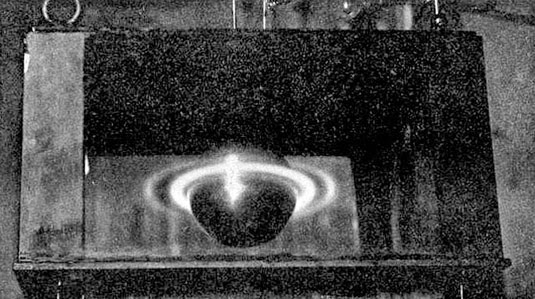 [Image: From Birkeland’s The Norwegian Aurora Polaris Expedition 1902-1903, Vol. 1: On the Cause of Magnetic Storms and The Origin of Terrestrial Magnetism (via)].
 [Image: Cropping in on the pic seen above (via)].
 [Image: Via
 [Image: Photo courtesy of
  [Image: Photo courtesy of
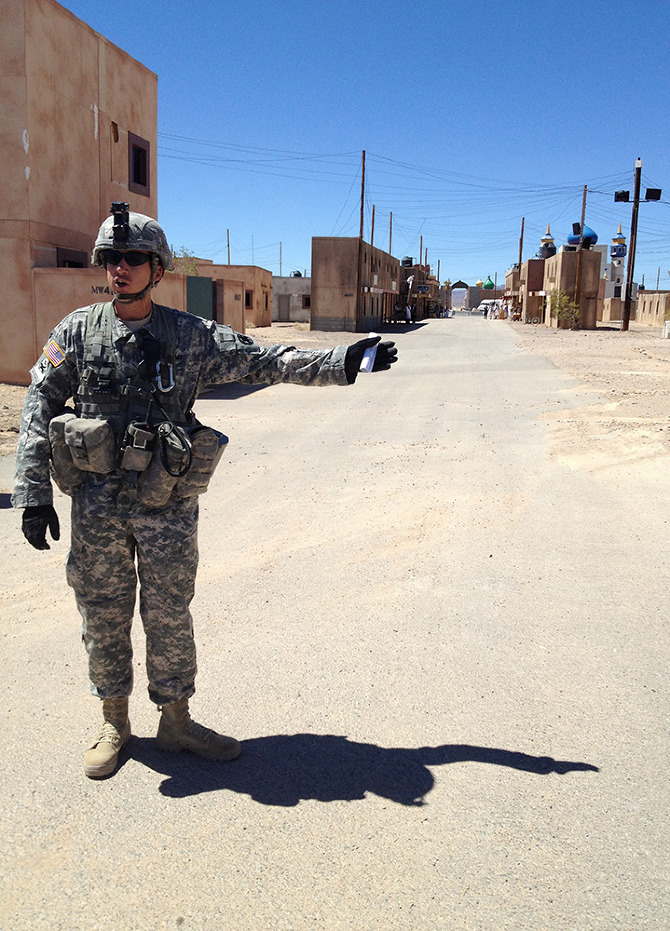
 [Images: Photos courtesy of
  [Image: Photo courtesy of
 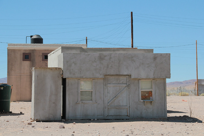 [Image: Photo courtesy of
  [Image: Photo courtesy of
 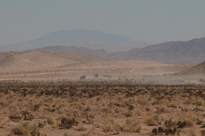 [Image: Photo courtesy of
  [Image: Photo courtesy of
  [Image: Photo courtesy of
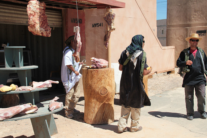
 [Images: Photos courtesy of
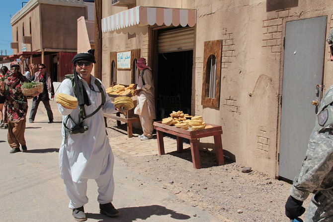
 [Images: Photos courtesy of
  [Image: Photo courtesy of
  [Image: Photo courtesy of
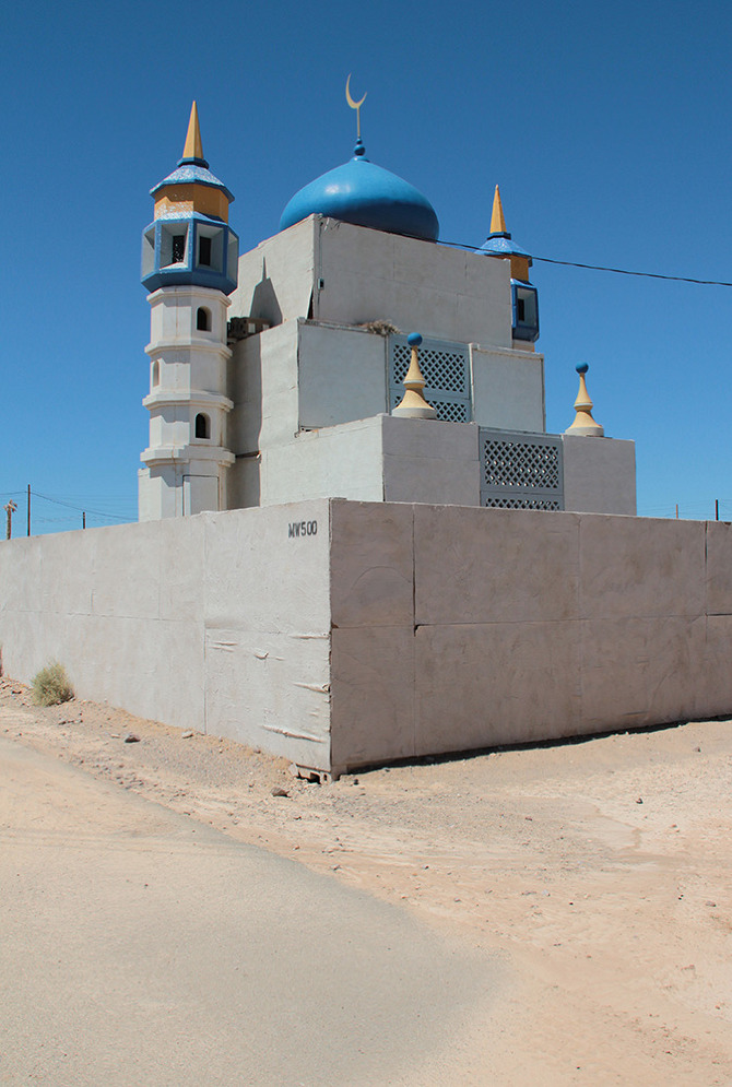
 [Images: Photos courtesy of
  [Image: Photo courtesy of
  [Image: Photo courtesy of
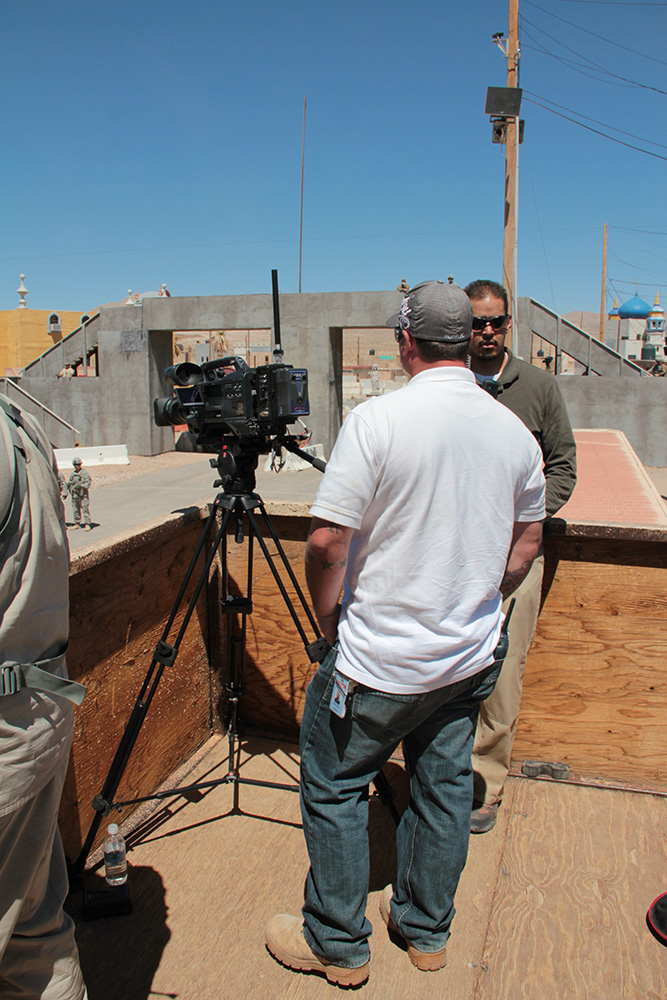
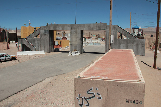 [Images: Photos courtesy of
  [Image: Photo courtesy of
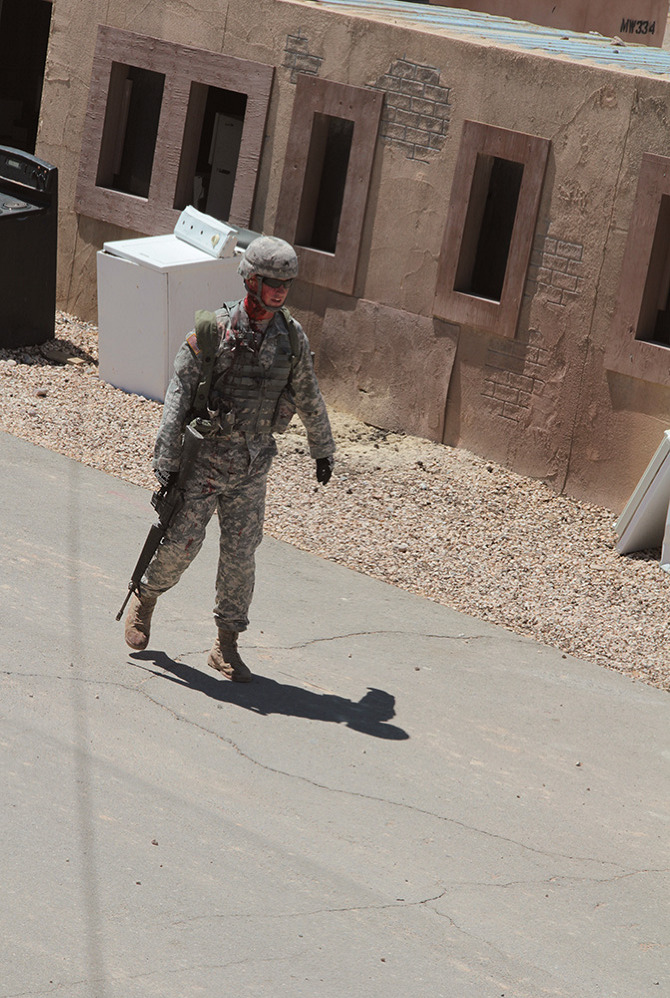
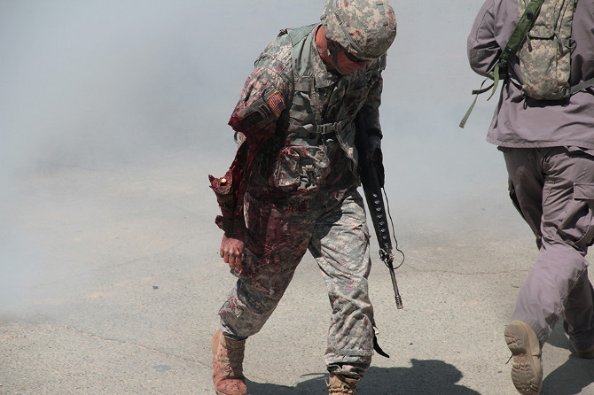
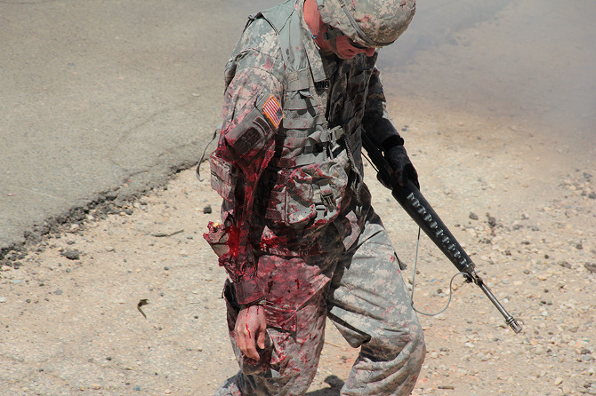
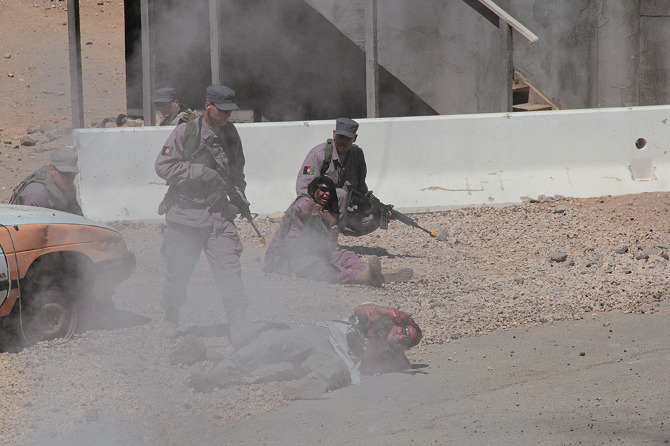
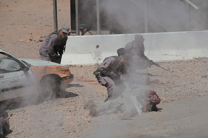
 [Images: Photos courtesy of
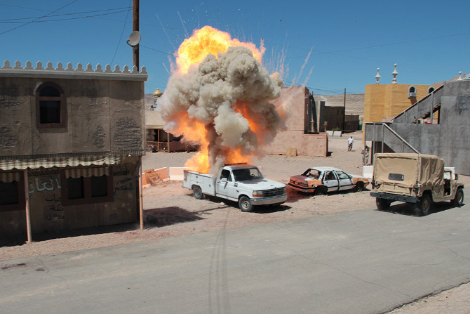
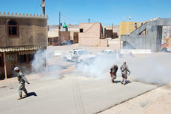
 [Images: Photos courtesy of
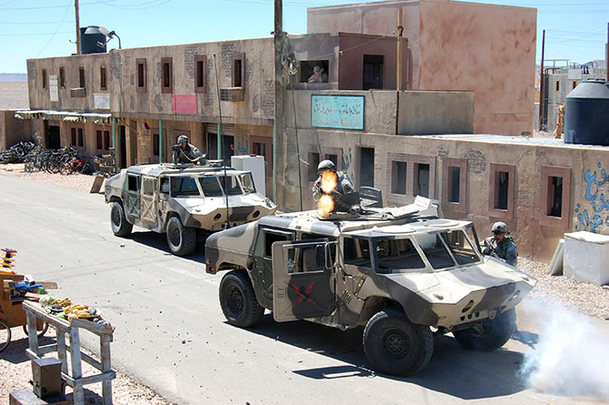
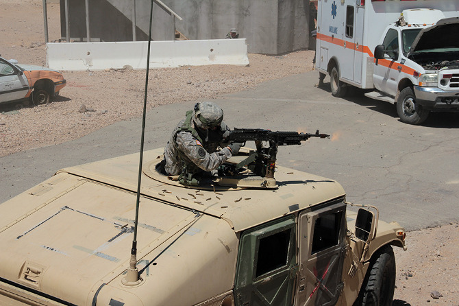
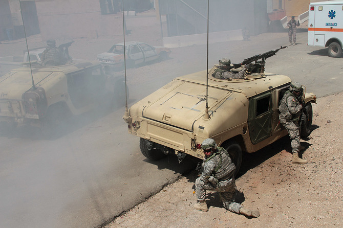
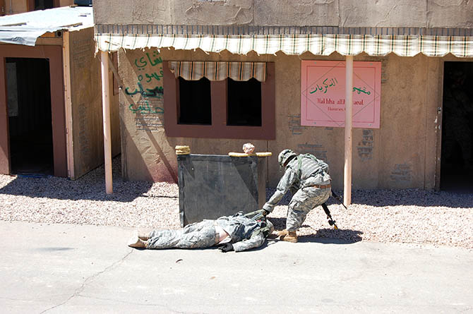
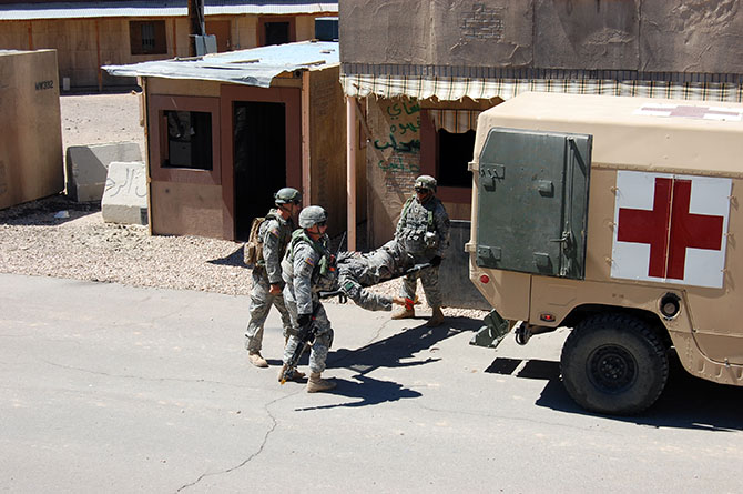
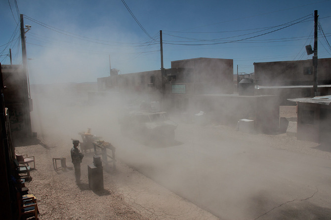
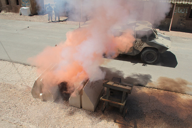
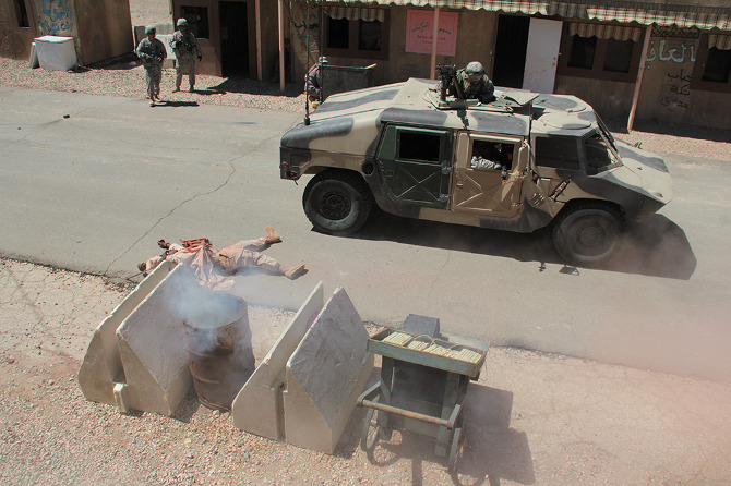
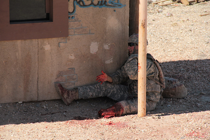
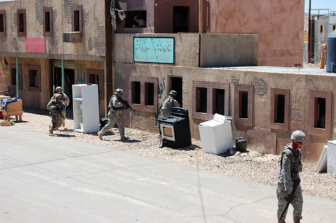
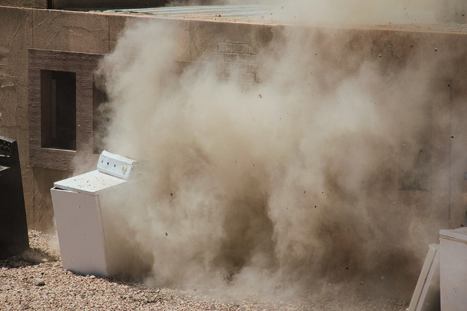 [Images: Photos courtesy of
  [Image: Photo courtesy of
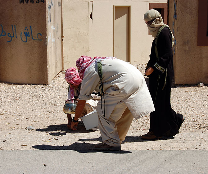
 [Images: Photos courtesy of
 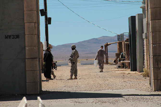 [Image: Photo courtesy of
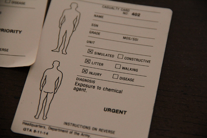
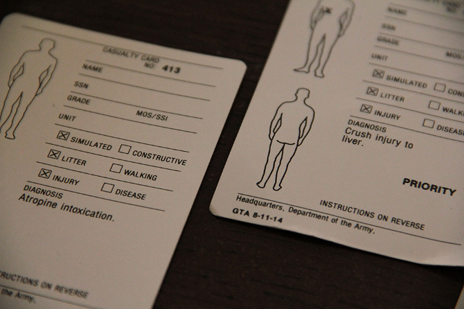
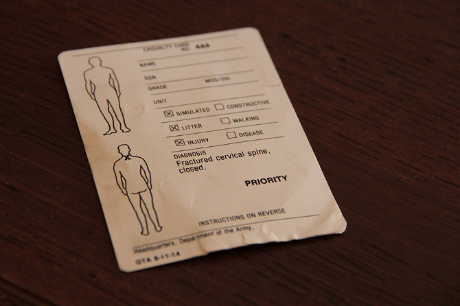
 [Images: Photos courtesy of
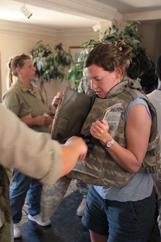
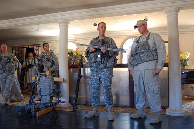
 [Images: Photos courtesy of
  [Image: Photo courtesy of
 [Image: Screenshot of our own SimCity—called, for reasons that made sense at the time, We Are The Champignons—after three hours of game play].
 [Image: A


 [Image: Using the zoning tool for the city designed by We Are the Champignons].
 [Images: Stone Librande’s storyboards for “Green City” and “Mining City” at the start of play].
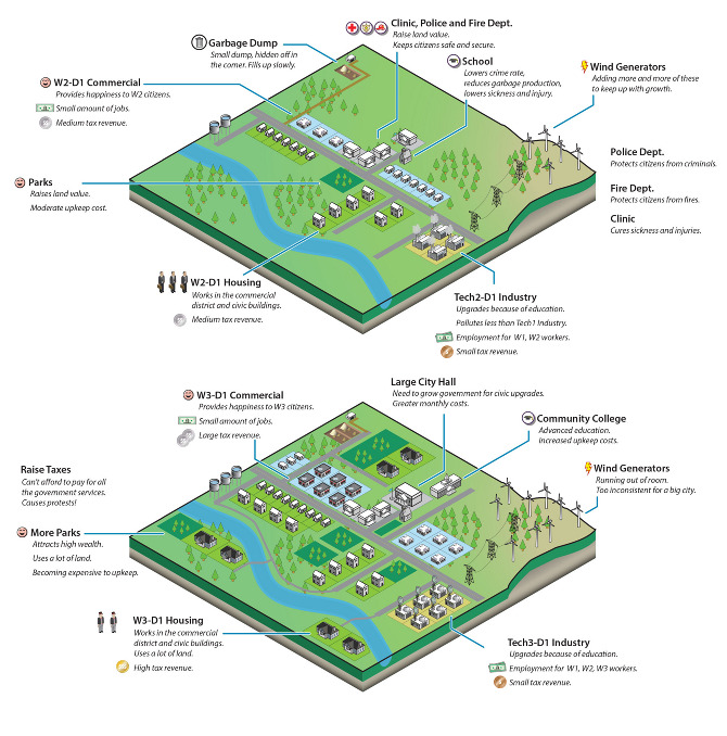 [Image: Stone Librande’s storyboard for “Green City” at mid-game].
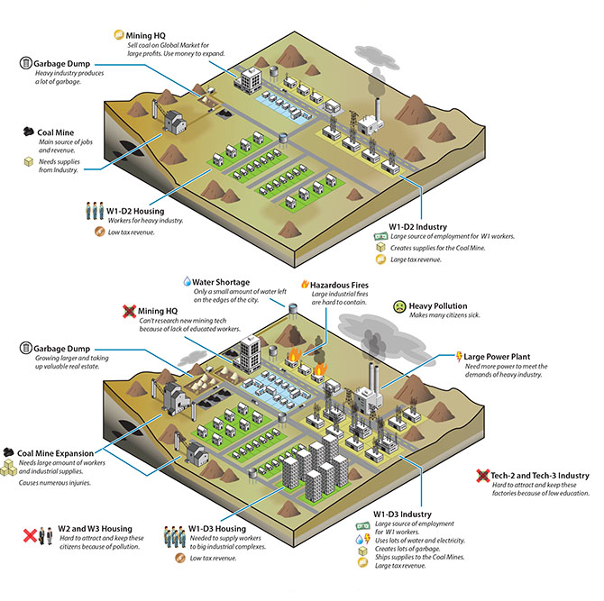 [Image: Stone Librande’s storyboard for “Mining City” at mid-game].
 [Image: Stone Librande’s storyboard for the “Green City” and “Mining City” end-game symbiosis].
 [Image: Data layer showing ore deposits].
 [Image: Data layer showing happiness levels. In SimCity, happiness is increased by wealth, good road connections, and public safety, and decreased by traffic jams and pollution].
 [Image: A regional view of a SimCity game, showing different cities and their painfully small footprints].
 [Image: Screenshot from SimCity 4].
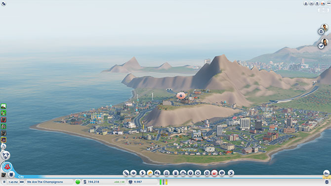 [Image: A fire breaks out in the city designed by We Are The Champignons].
 [Image: Sims queue for the bus at dawn].
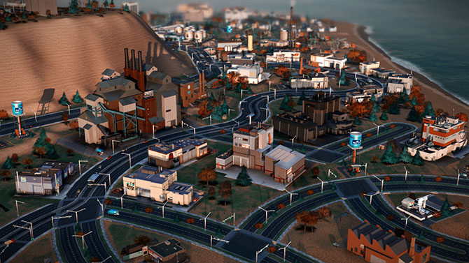 [Image: We Are The Champignons’ industrial zone, carefully positioned downwind of the residential areas].


 [Image: A Starfish site, like a pyromaniac’s version of
  [Image: A Starfish site burning, via the
  [Image: Zooming-in on the Starfish site, seen above; image via the
 [Image: Yodaville, via
 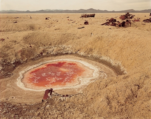 [Image: Photo by Richard Misrach, courtesy of the
 [Image: Photo by
 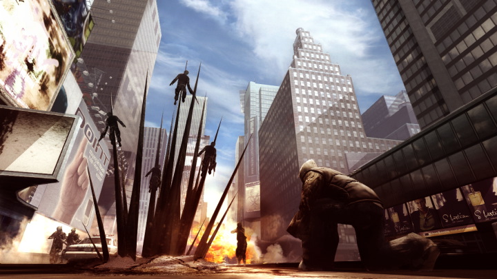 [Image: From
 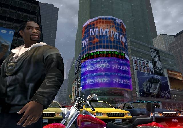 [Image: From
 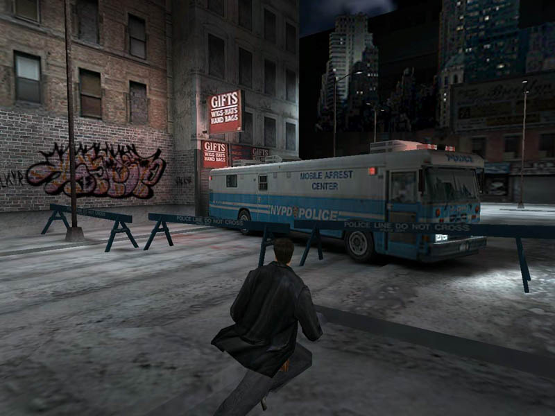 [Image: From
 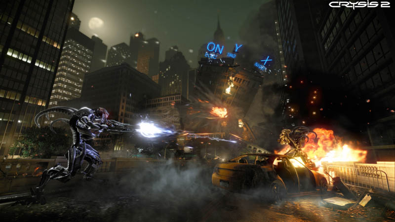 [Image: From
 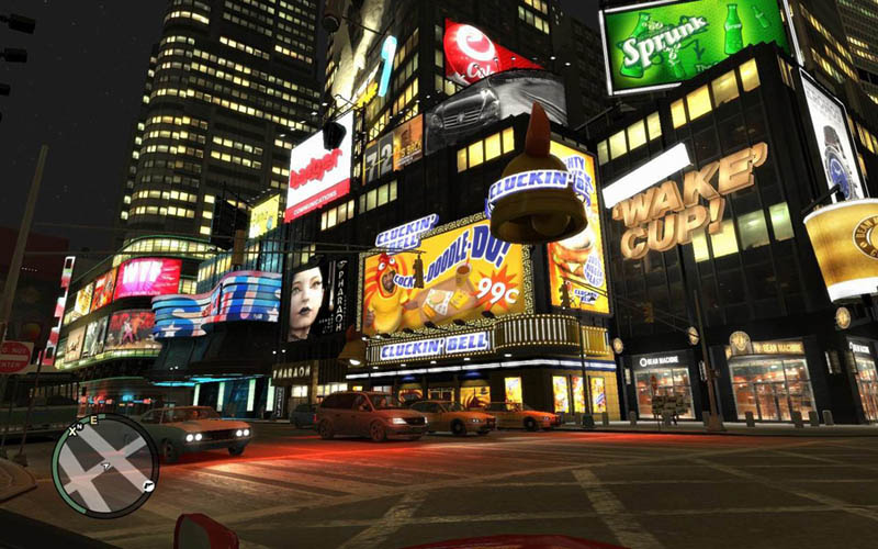 [Image: From
 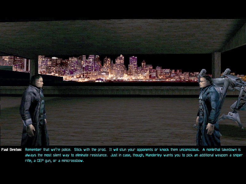 [Image: From
  [Image: Photo by Barney Peterson, courtesy of the
  [Image: Photo by Barney Peterson, courtesy of the
  [Image: The CAVE at the Desert Research Institute in Reno, now called the
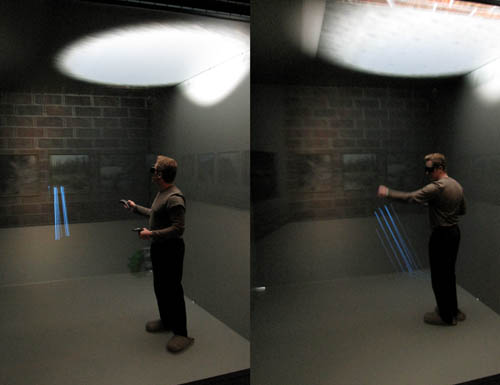 [Image: Daniel Coming, Principle Investigator of the
  [Image: Touring virtual light].
 [Image: Cthulhoid satellites appear in space before you, rotating three-dimensionally in silence].


 [Images: Photos by BLDGBLOG and
  [Image: The
  [Image: Brains].
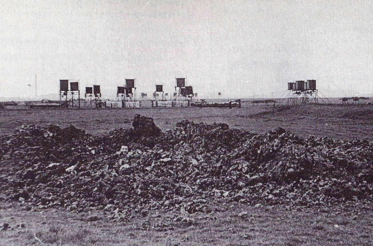
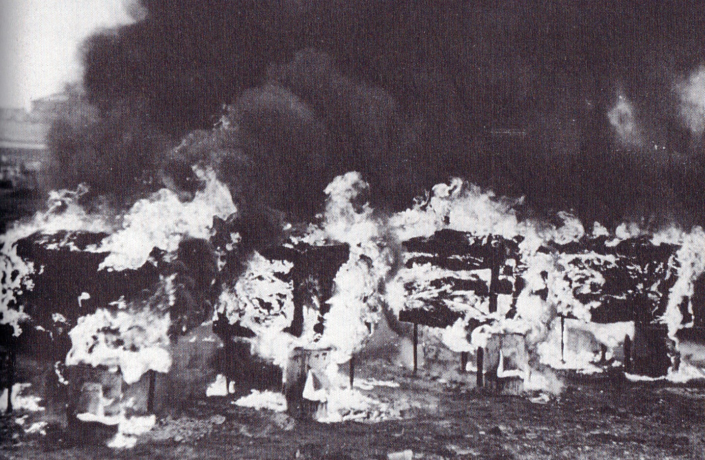