The exact acoustic shape of
the skies above Los Angeles

[Image: Photo by John Gay: an F/A-18 creates a condensation cone as it breaks the speed of sound].

An email was sent out last week from the Regional Public & Private Infrastructure Collaboration Systems (RPPICS) – an organization with no apparent web presence – warning many businesses in and around Los Angeles that city residents “could hear up to a dozen sonic booms this morning [June 11] as some NASA F/A-18 aircraft fly at supersonic speeds around Edwards Air Force Base.”

While the “loudness of the booms will vary,” we read, these are only “preliminary calibration flights for an upcoming NASA study” that will research how “to reduce the intensity of sonic booms.” Part of this will be studying “local atmospheric conditions,” including air pressure, wind speed, and humidity, as these all entail acoustic side-effects.

It’s a sonic cartography of the lower atmosphere: an echo-location exercise. The geometry of noise.

Sound-bombing L.A. from above in order to know the exact acoustic shape and structure of the sky.

Acqua Veritas

The city of Venice has begun to rebrand its tap water, calling it Acqua Veritas, in an attempt to woo both residents and tourists away from the environmental hazards (and waste collection nightmare) of bottled water.
After all, Italians are “the leading consumers of bottled water in the world,” the New York Times reports, “drinking more than 40 gallons per person annually.” Further, “Venice’s tap water comes from deep underground in the same region as one of Italy’s most popular bottled waters, San Benedetto” – so turning Venetians on to the miracles of the tap (and setting an example for cities elsewhere) is clearly overdue.
However, as we saw earlier on BLDGBLOG, in a guest post by Nicola Twilley, bottled water now sits on the cusp of becoming as pretentious as the wine industry, complete with a developing vocabulary for taste preferences and even an emerging geography of aquatic terroir. In other words, it will be hard to break the Duchampian habit of seeking water in a bottle. Why Duchampian?
Because bottled water is the ultimate readymade object; I’d even suggest that Marcel Duchamp very nearly discovered the bottled water industry when he first captured 50 cc of Paris Air, in an artwork of the same title, back in 1919.

[Image: Marcel Duchamp, 50 cc of Paris Air (1919), courtesy of the Philadelphia Museum of Art].

It’s hard not to wonder what might have happened had Marcel Duchamp been alive just slightly later, and able to exhibit his artwork alongside – or even simply to hang out with – Andy Warhol; combine the readymade object with Warholian mass reproduction, substitute pure glacial water for Paris air, and perhaps today we’d all be drinking L’Eau de Duchamp.
In any case, if cities around the world engaged in marketing campaigns similar to this one in Venice, however tongue-in-cheek it may be, might people finally regain interest in their own municipal water supplies?
Croton Silver: The Taste of Manhattan™.

(Vaguely related: The next bottled water industry? Chinese Air Bars).

Serving Space

Tom Vanderbilt – author of the excellent book Survival City: Adventures Among the Ruins of Atomic America, as well as the recent Traffic, and subject of a short but interesting interview in The BLDGBLOG Book – has a long article out in the The New York Times Magazine about the architecture (and energy implications) of large-scale data centers.
This is the world of “increasingly large, powerful, energy-intensive, always-on and essentially out-of-sight data centers” that now dot the global landscape.
What is this new type of space? “Call it the architecture of search,” Vanderbilt writes: “the tens of thousands of square feet of machinery, humming away 24/7, 365 days a year – often built on, say, a former bean field – that lie behind your Internet queries.”
Such buildings often blend in with the everyday urban landscape. For instance, Vanderbilt describes “NJ2, a data center located in Weehawken, N.J., just through the Lincoln Tunnel from Manhattan.” It is “an unmarked beige complex with smoked windows”; inside it “hum the trading engines of several large financial exchanges.”
The interesting thing here is that the machines stored inside NJ2 are stored there so that they can be as close as possible, geographically, with other machines: the ones that handle trades on Wall Street. Spatial proximity, in this case, cuts down on information-relay time, thus enabling large-scale financial processes to unfold nearly in real-time.
We might say, then, that the built environment you see here – the distances between buildings and their urban or geographical locations – is thus an articulation not of architectural theory or of the stylistic assertions of one particular architect, but of the processing power of today’s supercomputers.
Future changes in processing speed might then ramify outward to further tweak the built environment.
Vanderbilt explains that when the Philadelphia Stock Exchange moved its computers north, into NJ2 – a distance, we read, of 80 miles – they saved three milliseconds on every trade. Lest we laugh that off as the spatial equivalent of obsessive-compulsive disorder, we’re told that “it is estimated that a 100-millisecond delay reduces Amazon’s sales by 1 percent.”
It’s an awesome article – check it out if you get a chance.

Whoever Rules the Sewers Rules the City

UCLA’s cityLAB has launched a new design competition called (somewhat lamely) WPA 2.0, where the WPA refers to the Works Progress Administration. But the competition itself looks cool.
Its tagline? Whoever Rules the Sewers Rules the City.
It’s a call for new visions of urban infrastructure:

We encourage projects that explore the value of infrastructure not only as an engineering endeavor, but as a robust design opportunity to strengthen communities and revitalize cities. Unlike the previous era, the next generation of such projects will require surgical integration into the existing urban fabric, and will work by intentionally linking systems of points, lines and landscapes; hybridizing economies with ecologies; and overlapping architecture with planning.

Sounds good in the abstract, but what are they specifically looking for? Quite a range:

This notion of infrastructural systems is intentionally broad, including but not limited to parks, schools, open space, vehicle storage, sewers, roads, transportation, storm water, waste, food systems, recreation, local economies, “green” infrastructure, fire prevention, markets, landfills, energy-generating facilities, cemeteries, and smart utilities.

Judges include Stan Allen, Cecil Balmond, Elizabeth Diller, Walter Hood, Thom Mayne, and Marilyn Jordan Taylor – two of whom (Allen and Diller) I’m proud to say that I’ve served I’ve been on design juries with in the past.
Here’s the competition brief as a downloadable PDF. Read more at the competition website – and good luck!

The Great Lakes Paleolandscapes Project

[Image: Evidence of an ancient hunting site; photo by John O’Shea, courtesy of ScienceDaily].

In archaeological news, evidence of an ancient human settlement, including “caribou-hunting structures and camps,” has been found deep beneath the waters of Lake Huron.

“More than 100 feet deep in Lake Huron,” ScienceDaily reports, “on a wide stoney ridge that 9,000 years ago was a land bridge, University of Michigan researchers have found the first archaeological evidence of human activity preserved beneath the Great Lakes.”

Of course, this goes rather well with our earlier look at the so-called “Lake Michigan Stonehenge.”

In any case, it sounds like the Great Lakes need their own version of the North Sea Paleolandscapes project, an unbelievably interesting archaeological program, run by the University of Birmingham, that hopes “to rediscover Doggerland, the enigmatic country which once linked the Yorkshire coast with a stretch of Continental Europe from Denmark to Normandy but which now lies beneath the North Sea.”

(Spotted via Archaeology Magazine).

The Hollow Hills

In a quick read through the consistently – and often amazingly – interesting links supplied by Archaeology Magazine, I came across an example of what is easily one of my favorite nonfiction plot twists: someone discovers that what they thought was a natural hill somewhere on their family property is actually an extremely ancient building.
It has an interior, perhaps even underground corridors linking to other, nearby hills.
It is not the surface of the earth, in other words, but a piece of architecture. Your backyard, to this way of thinking, might actually be a roof; you simply have to discover a way inside the building deep below.

[Image: The artificial hill at Cuween, an Orkney burial cairn, perhaps anticipating by thousands of years the architecture of Vicente Guallart; photos by Sigurd Towrie of Orkney Jar].

In this case, we read, a farmer in the Orkney Islands of northwest Scotland, while plowing a relatively untouched field on his family land, uncovered a Neolithic chambered tomb just sitting there beneath the soil.
It was a room – and suddenly he had access to it.
“The structure itself is neat drystone construction,” a local archaeologist explains, and “the wall curves round tightly and is beehived in by corbelling at the top. On the opposite side to the wall is a space topped by lintels, and indeed it was breaking one lintel that caused the site to be found. It’s early days yet, but it may be a Neolithic chambered cairn, some five or six thousand years old.”
Of course, readers of The BLDGBLOG Book, finally published this week in the United States, will recognize this same idea from the beginning of that book’s “Underground” chapter (where the discovery of a tomb now known as Crantit Cairn is described in slightly fictionalized form). The bare bones of that story, however, are worth repeating here: one day, back in 1998, we read, a farmer “decided to plough [his] field in a different direction to normal – a seemingly insignificant decision that led to the discovery of what was hailed as one of ‘the greatest archaeological finds of recent years.'”
Specifically, “While ploughing, the tractor disturbed the roof of the tomb, dislodging a roofing slab. The slab fell to reveal a hole and daylight streamed into the underground chamber for the first time in millennia.”
With today’s penchant for green roofs and other forms of “vegitecture,” one wonders if similar such experiences might become exponentially more common in the distant future; two kids, playing around in the garden, pull a stone up from the flowerbed only to discover that they are standing atop the main gallery of a science museum constructed back in 2009 A.D.
Zork Begins.
In fact, as I mentioned in my lecture at the School of Visual Arts in New York back in April, a similar sort of idea made a cameo appearance in The Day After Tomorrow. There, we watch as Dennis Quaid and his two colleagues are hiking across a rapidly forming glacier – only for one of them to crash through a skylight into the snow-buried mall below.
It was not a glacier at all, in other words, but an unrecognized architectural form.
In any case, perhaps the great human adventure of the year 45,000 A.D. will not be in outer space at all, but a terrifying Dantean super-tour through the deeply buried cities of our present age. People stumble through this seemingly endless underground labyrinth, spanning nearly the whole surface of the globe, utterly unaware of who created these buildings and why.
In this context, old Celtic/Britannic myths of the Hollow Hills take on an especially interesting architectural resonance. I’m yet further reminded of many bunkers in the hills around San Francisco; seen from one side, these buildings appear to be mere mounds covered with gravel and weedy vegetation, like a gently rolling, even bucolic American landscape – but, from the other side, you find that they have heavily rusted metal doors…
The implication here, that you could open a door and walk inside a manmade earth, where the hills around you are actually the roofs of old buildings, will never cease to amaze me.

Chinese Islam and the Case of the Disappearing Prison

What do you do when you’re trying to shut down a high-profile prison for unofficially accused international terrorists? Ship the prisoners off to a nation of disappearing islands.
The U.S. might shortly begin sending Chinese Muslim prisoners from its facility at Guantanamo Bay – itself an extra-judicial territory, or semi-sovereign administrative enclave, that both is and is not part of the United States – to a terrestrially complicated new situation in the Pacific island nation of Palau.
Palau, of course, is disappearing.
From one black hole to another, then.

(Via @pruned).

Watershed Down

[Image: Mike Bouchet’s Watershed being towed through Venice towards the Arsenale basin, against a backdrop of Italian palazzi].

Note: This is a guest post by Nicola Twilley.

The 2009 Venice Biennale opened this week with an unexpected and quite beautiful piece of performance art. Artist Mike Bouchet had built a one-to-one scale replica of a typical American surburban home that he planned to install on floating pontoons in the Venice Arsenale basin. He called the project Watershed.

David Birnbaum, the Biennale’s curator, told camera crews filming the installation that he thought the project “sounded a bit megalomaniac,” but the sight of the oversized house, clad in beige vinyl, flimsily bobbing up and down against a backdrop of palazzi and piazzi as it was towed through Venice’s canals, was breathtaking. It was an architectural icon of the American Dream revealed in all its formulaic absurdity.

Amazingly, then, one of the pontoons capsized, and the entire house sank to the bottom of the canal—an unintentional yet utterly perfect coda to the house’s own built-in commentary. Now, a fake generic American suburban home will add its ruins to the underwater archaeology of Venice.

[Image: Mike Bouchet’s Watershed goes down].

A two-minute video of the house’s journey, and eventual fate, can be seen in full on YouTube.

(Originally spotted on Flavorwire).

Mobile Street Furniture

Note: This is a guest post by Nicola Twilley.

Over the past two weeks, in two separate cities, multiple sightings of IDEO-like user-generated adaptations have reframed the motorbike as an intriguing addition to the emerging category of street furniture.

[Image: Photo by Lucy Crosbie, used under a Creative Commons license].

The first example was spotted outside Richard Rogers’s Channel 4 building in London, where a cluster of bike couriers had put their feet up onto their bikes’ handlebars, tipping their helmets down over their faces, and allowing the seats to form a gently curved cradle for their spines. They thereby squeezed in a quick nap between jobs.

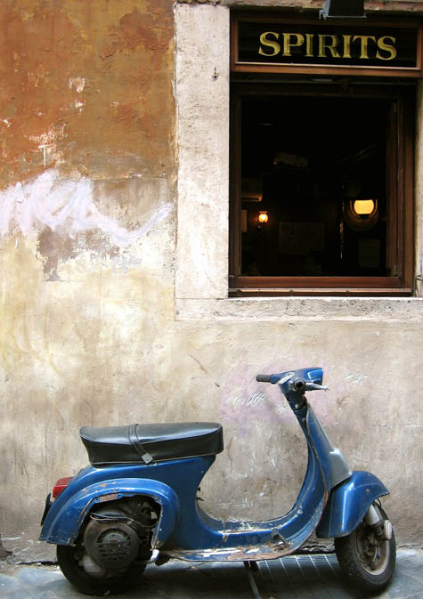
Then, last week, as the streets of Trastevere overflowed with Romans celebrating the Festa della Repubblica, an unlucky Vespa parked next to a bustling enoteca was claimed as a bar stool and drink stand by several different groups over the course of the evening.

In both cases, the bikes suddenly appeared remarkably well-designed for their off-menu functionality: the hammock-like seat cushion and broad, flat rear looked purpose-built for backs and beer, respectively. In fact, with just a few adaptations and some thoughtful urban planning, their potential as mobile street furniture could be taken to the next level.

Simple additions—such as a gently vibrating seat cushion to work out muscle knots while couriers are snoozing, or flip-out cup holders behind the seat of the Vespa—combined with reserved parking spots for motorbikes outside bars and popular brunch spots, would surely enhance city life.

Ambitious entrepreneurs could carve out a seasonal niche by deploying a fleet of specially customized motorbikes as on-demand mobile seating. Perhaps tourists visiting Rome for the day could even rent motorbikes in a shady side-street so as not to miss out on their expected siestas. And, particularly in London, where dedicated outdoor beer gardens—a losing proposition for at least three hundred days of the year, but the most desirable real-estate in the city on those few hot, sunny days—smart publicans would eagerly pay to rent a dozen Vespa bar stools for their clientele to enjoy.

In each case, the motorbikes would be gone by the time pedestrian and vehicle traffic started up again—their mobility ensuring that streets and sidewalks remain uncluttered at peak flow.

It would only be a matter of time before low-platform flat-bed trucks had rentable sofas installed in the back and were then parked at scenic overlooks, while empty lorries were re-purposed as hammock dormitories, circling airport terminals to snap up jet-lagged travelers intent on maximizing layover time. The first international Mobile Street Furniture Conference in Milan would be swiftly followed by the creation of an industry-sponsored urban planning lobbying arm, high-profile design contests, and premium membership schemes, allowing unlimited worldwide street furniture rental…

[Other guest posts by Nicola Twilley include Watershed Down, The Water Menu, Atmospheric Intoxication, Park Stories, and Zones of Exclusion].

Pardon the Disruption

Just a quick note that I’m off to Turin tomorrow to participate in a conference called I Realize: The Art of Disruption, if any readers out there are in that city of long shadows and automobiles.

[Image: The massive Mole Antonelliana, Turin (1875); view larger].

The point of the conference is to look at “breaking radically with the past, moving the horizon and embracing ambitious challenges.”
Even better, it takes place inside a “Virtual Reality & Multimedia Park” (here’s a map) – and the other speakers include the one and only Bruce Sterling, legendary designer Peter Saville, architect Andrea Branzi, Nicolas Nova, Jennifer Higgie, Gianluigi Ricuperati, Nicola Perullo (director of Slow Food Italia), and many, many others.
If you’re around, be sure to introduce yourself (although my Italian, unfortunately, è inesistente).

Urban X-Ray / Ancient Orchard

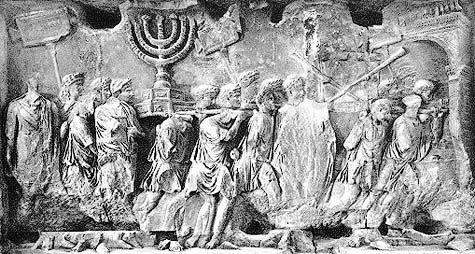
[Image: A Roman Triumph following the sack of Jerusalem].

Amongst the many books I’m reading here in Rome this month – including Tobias Jones’s surprisingly good Dark Heart of Italy, the incredible Anatomy of Fascism by Robert Paxton (J.G. Ballard wrote that he “found Paxton’s post-mortem deeply unsettling, with its strong hint that the corpse [of fascism] might sit up at any moment and seize us by the throat” – Exhibit A here might be Andrew Brons‘s election this week to the European Parliament), and Roger Deakin’s Waterlog – I’m making my way through two books by Mary Beard.
Beard, of course, was the subject of a long, two-part interview with BLDGBLOG back in 2007.
What I want to mention here comes from her book The Roman Triumph; it’s only a brief quotation, but I like it.
At one point Beard refers to the “theaters and porticoes” built in ancient Rome using wealth taken during Pompey‘s “eastern campaigns” in Armenia and elsewhere. However, she writes:

The term “theaters and porticoes” hardly does justice to this vast building complex, which stretched from the present day Piazza Campo del Fiori to the Largo Argentina, covering an area of some 45,000 square meters. A daring – and, for Rome, unprecedented – combination of temple, pleasure park, theater, and museum, it wrote Pompey’s name permanently into the Roman cityscape. Even now, though no trace remains visible on the ground, its buried foundations (and particularly the distinct curve of the theater) determine the street plan and housing patterns of the city above; it remains a ghostly template which accounts for the surprising twists and turns of today’s back-streets, alleyways, and mansions.

The not entirely surprising realization that the present-day street grid of Rome is actually an articulation of other, previously buried cities – cities not lost to history, then, but accessible in outline through the indirect archaeology of contemporary urban planning – reminds me of something that came up back at Postopolis! LA.

[Image: Fallen Fruit‘s map of the lost orchards of Silver Lake].

During their presentation, the ingenious duo Fallen Fruit mentioned that, when they were mapping fruit trees in today’s Los Angeles, they stumbled upon the borders of much older, abandoned fruit orchards.
In other words, what appeared simply to be a random fig tree growing in someone’s front yard was, when seen on a map together with other such trees, actually the remnant presence of a now-forgotten farm.
Those trees, to use Beard’s term, are the “ghostly template” from an earlier phase of land use.
There is a different grid inside the grid, you might say – where each tree becomes something like a legal document, marking the outer boundaries of a lost landholding.
Of course, both of these examples together bring to mind the lost airports of Los Angeles, those geographies of aerial experience that now sit buried and all but forgotten beneath millions of tons of pavement throughout the greater L.A. region.
Other such examples are easy to come by – but their interest, for me, never dissipates. Whether it’s the lost rivers of London still giving shape to the street plan above (or lost streams of Manhattan turning into underground fishing ponds), there are remnant geographies and ghostly templates everywhere.
In fact, as I recently wrote in an introduction to photographer Shaun O’Boyle’s forthcoming book Modern Ruins: Architectural Monuments of the Mid-Atlantic – definitely check it out upon publication in 2010 – this even includes our own bodies: forgotten anatomies still make themselves known through the structure and layout of our nerves and bones.
But Rome, Los Angeles, London – these urban examples simply give our ghostly ancestors architectural shape.