Katrina 3: Two Anti-Hurricane Projects (on landscape climatology)

Project 1: “How do you slow down a hurricane?”
In the June 2005 edition of The Economist Technology Quarterly (subscription required), we read about Moshe Alamaro, “a scientist at the Massachusetts Institute of Technology, [who] has a plan. Just as setting small, controlled fires can stop forest fires by robbing them of fuel, he proposes the creation of small, man-made tropical cyclones to cool the ocean and rob big, natural hurricanes of their source of energy. His scheme, devised with German and Russian weather scientists and presented at a weather-modification conference in April, involves a chain of offshore barges adorned with upward-facing jet engines.”


“Each barge creates an updraft, causing water to evaporate from the ocean’s surface and reducing its temperature. The resulting tropical storms travel towards the shore but dissipate harmlessly. Dr Alamaro reckons that protecting Central America and the southern United States from hurricanes would cost less than $1 billion a year. Most of the cost would be fuel: large jet engines, he observes, are abundant in the graveyards of American and Soviet long-range bombers.”
The creation of manmade tropical micro-storms, using heavy, greenhouse gas-burning jet engines towed through the waters of the equatorial Atlantic on what are, for all intents, artificial islands… is really a pretty ridiculous idea.
Yet it reminds me of a long-standing BLDGBLOG project that has otherwise gone unpublished. Till now:

Project 2: The Aeolian Reef
In Virgil’s *Aeneid*, translated by Robert Fitzgerald, we read about “Aeolia, the weather-breeding isle”:

“Here in a vast cavern King Aeolus
Rules the contending winds and moaning gales
As warden of their prison. Round the walls
They chafe and bluster underground. The din
Makes a great mountain murmur overhead.
High on a citadel enthroned,
Scepter in hand, he molifies their fury,
Else they might flay the sea and sweep away
Land masses and deep sky through empty air.
In fear of this, Jupiter hid them away
In caverns of black night. He set above them
Granite of high mountains – and a king
Empowered at command to rein them in
Or let them go.” (Book 1, Lines 75-89)

Thus: BLDGBLOG’s Aeolian Reef.
To be fair, this all began as nothing more than an idea for a new, artificial island that would be added to the Cyclades archipelago in Greece. It would be somewhere between Constant’s Babylonic mid-sea pavilion –


– an oil derrick –


– the Maunsell Towers


– and a kind of massive, off-shore, geotechnical saxophone.
Full of vaulted tubes and curved ampitheaters – and complex twists through a hollow, polished core – this modern Aeolia, an artificial island, would produce storms (and even, possibly, negate them).
A modern Aeolia, in other words, would be a “weather-breeding isle” – or a “weather-cancelling isle,” as the case may be: because then there was Katrina.
What would happen, I thought, if you built a manmade, weather-cancelling isle that could *stop hurricanes from forming*? I realized, of course, immediately, that you would actually need hundreds of these tuba-like, anti-hurricane islands – even an entire manmade archipelago of them – because the atmospheric paths of storms are far too unpredictable.
You would need, that is, an Aeolian Reef.
The Aeolian Reef – and the current author, who cannot draw, hint-hint, would *love* to collaborate with any BLDGBLOG readers who want to illustrate some of these things – would consist of oil derrick-like platform-islands built in climatologically influential patterns throughout both the Gulf of Mexico and the larger, equatorial Atlantic.
The Aeolian Reef would: 1) trap and redirect high-speed winds from any burgeoning tropical storms and hurricanes, thus preventing them from actually forming; 2) provide incredibly exciting meteorological/atmospheric observation platforms far out at sea; and 3) be readily exportable to other countries and other climates, for other purposes – land-based anti-tornado clusters, for instance.
This would therefore take the subject of an earlier BLDGBLOG post a few steps further: it would use architecture, or landscape architecture, as a way to directly influence, change, or redirect the climate.
It would, in short, be *landscape climatology*.
One could imagine alternative uses, of course; even a computer glitch or global supervillain who rearranges all the internal valves of the Aeolian Reef to generate the mother of all hurricanes… in which case the Reef would be something of a national security threat.

This thread continues in Katrina 1: Levee City (on military hydrology); and Katrina 2: New Atlantis (on flooded cities).

Katrina 2: New Atlantis (on flooded cities)

New Orleans is not the only city to be faced with a future of indefinite flooding – nor is it the only city in the world below sealevel.
The entire nation of the Netherlands, for instance, provides perhaps the most famous example of urbanized land reclaimed from the Atlantic seafloor. “Polders” is the Dutch name for such rigorously flood-controlled territory, and an exhibition literally even now being held at the Rotterdam-based Netherlands Architecture Institute explores the polders’ geotechnical creation.
The polders’ “rationally organized landscape is unique, but also vulnerable,” the NAI explains. Vulnerable to overdevelopment – as well as to catastrophic flooding.
The 2005 Rotterdam International Architecture Biennale, in fact, takes nothing less than “The Flood” as its central, organizing theme – with one particular sub-focus being Water City*.


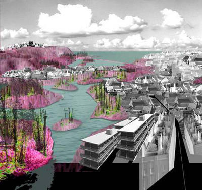
[Image: The metropolis, the flood, the boundaries of architectural design.]
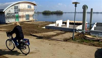
In April and May, 2005, The New Yorker ran a three-part article by Elizabeth Kolbert, called “The Climate of Man,” on the subject of human-induced climate change. The third part, published on 9 May 2005, ends with a description of how “one of the Netherlands’ largest construction firms, Dura Vermeer, [has] received permission to turn a former R.V. park into a development of ‘amphibious homes'” – a floating city. (The Guardian also has an article about this.)
“The amphibious homes all look alike,” Kolbert says. Floating on the River Meuse in Maasbommel, “they resemble a row of toasters. Each one is moored to a metal pole and sits on a set of hollow concrete pontoons. Assuming that all goes according to plan, when the Meuse floods the homes will bob up and then, when the water recedes, they will gently be deposited back on land. Dura Vermeer is also working to construct buoyant roads and floating greenhouses” – the entire human race gone hydroponic.
As Dura Vermeer’s environmental director says: “There is a flood market emerging.”


[Image: A floating house, moored to the earth, in Maasbommel.]
Further afield, the year 2005 has seen major flooding in Europe, India, and Bangladesh, to name but a few sites of major hydrological catastrophe.
In Mumbai, India, *The Economist* explains, the 2005 floods “uncovered long-term failures. Not enough had been done to maintain Mumbai’s ageing infrastructure, such as storm-drains and sewers. Worse, new building had weakened the city’s defences. Large areas of protective mangrove had been razed – in one notorious example, to make way for a golf course. Developers have built on wetlands, clogging natural drainage channels. River banks have been reclaimed and become slums.”


And then there is Bangladesh. “From the air,” we read, also in The Economist (most of their articles are for subscribers only, it’s really irritating), “Bangladesh looks less like a country than one vast lake, dotted with thousands of tiny islets, clumps of trees and houses. Few boats ruffle the placid floodwaters: there is nowhere to go.” And yet “[t]he great lake of Bangladesh is in reality a network of nearly 250 rivers.”
New Orleans, Rotterdam, Bangladesh, Mumbai: 2005 will be the year of flooded infrastructure and overwhelmed cities.
And so if Atlantis sets the gold standard for civilizations lost to floods – forget Noah – then it’s interesting that Atlantis, even before Katrina occurred, was back in the news this year (though I suppose it is every year). As already explored elsewhere on BLDGBLOG, Atlantis’s island home may (or may not) be in the Straits of Gibraltar.
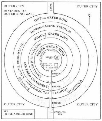
The real issue, however, that the infrastructural possibility of Atlantis brings to the fore – or, rather, that Katrina brings to the fore, through the hydrological destruction of New Orleans – is revealed quite clearly in the following artist’s representations of what Atlantis might have looked like:


Atlantis, city of dikes and levees, city of canals and inland seas, city of water-smart urban design and hydrological planning – it, too, was swallowed by the oceans, and destroyed.

This thread continues in Katrina 1: Levee City (on military hydrology); and Katrina 3: Two anti-hurricane projects (on landscape climatology) – both on BLDGBLOG.

Katrina 1: Levee City (on military hydrology)

[Policing the earth: a military helicopter surveys a flooded metropolis under martial law.]

It’s too easy, not to mention slightly vindictive, to blame all of hurricane Katrina’s catastrophic impact and aftermath on the Army Corps of Engineers; but it is worth remembering that New Orleans – in fact the near totality of the lower Mississippi delta – is a manmade landscape that has become, over the last century at least, something of a military artifact. To say that New Orleans is, today, under martial law, is therefore almost redundant: its very landscape, for at least the last century, has never been under anything *but* martial law. The lower Mississippi delta is literally nothing less than landscape design by army hydrologists.
New Orleans as military hydrology.
Or, military urbanism as a hydrological project.
According to The Economist, “For much of the 20th century the federal government tampered with the Mississippi, to help shipping and – ironically – prevent floods. In the process it destroyed some 1m acres of coastal marshland around New Orleans – something which suited property developers, but removed much of the city’s natural protection against flooding. The city’s system of levees, itself somewhat undermaintained, was not able to cope.”
When even people within the Army Corps of Engineers began to warn that the hubristic landscape design methods of the US military might actually be inappropriate for what is a very muscular, flood-prone, not-to-be-fucked-with drainage basin, the warnings were taken – well, frankly, they were probably taken to be blatantly unpatriotic, knowing what’s happened to this country. But I digress.
“There is an irony,” The Economist elsewhere continues, “in this warning coming from the Corps of Engineers. Just as with the Everglades in Florida, New Orleans’s vulnerability has been exacerbated by the corps’ excellence in reshaping nature’s waterways to suit mankind’s whims. In the middle of the last century, engineers succeeded in re-plumbing the great Mississippi… [which simply] hastened erosion of the coastal marshes that used to buffer New Orleans, leaving the city needlessly exposed. Most of the metropolitan area lies below sea level on drained swamp land. Levees normally hold back the Mississippi and Lake Pontchartrain, but those were not designed to handle the waters that would come with such a powerful hurricane.”
Those same levees, in fact, as we all know, are actually now responsible for keeping the flood waters in:


“‘We’ve been living in this bowl,’ said Shea Penland, a coastal geologist who has studied storm threats to Louisiana for years,” in an interview with The New York Times. “‘And then Katrina broke channels into the bowl and the bowl filled. And now the bowl is connected to the Gulf of Mexico. We are going to have to close those inlets and then pump it dry.'”
But pumping the flooded city dry will be a “hard task,” according to the somewhat characteristic understatement of the BBC, in an article that then outlines the various steps of the engineering strategy involved (included new causeways, steel sheets, and 300-lb. sandbags).
But even if New Orleans is “pumped dry,” even if the city is eventually drained, even if commerce returns and the Big Easy’s population goes back to life as usual, there is still a much larger problem to face.
The Economist: “America’s Geological Survey has estimated that if nothing is done by 2050, Louisiana will lose another 700 square miles of coastal wetlands. Various local groups have long called for reconstruction of the marshes along the lines of the troubled $10 billion Everglades rejuvenation project. The New Orleans version, which would cost $4 billion more, would divert some 200,000 cubic feet of water each second from the Mississippi 60 miles through a channel to feed the existing marsh and to build two new deltas. The plan, which would also shut canals and locks to keep out salt water and would build artificial barrier islands, may find more adherents.”
Artificial barrier islands; 200,000 cubic feet of water each second; two new deltas: if at first you don’t succeed… try ever more elaborate feats of hydrological engineering. More of the disease is the cure for the disease. (See here for a much older – yet no less impressive for being small-scale – example of complex hydrological engineering).
Katrina, in this context, becomes a problem of landscape design.
The “hurricane” as an atmospherically-interactive, military-hydrological landscape problem.

[NASA satellite image: the Mississippi delta – several hundred square miles smaller than it should be.]

It’s a question, in other words, of human geotechnical constructions and how they interact with the complex dynamics of the earth’s tropical atmosphere and waterways.


[Image: Nearly all of the Atlantic’s equatorial reserves of warm water contributed to the strength of the storm. A few levees didn’t stand a chance.]
So what may soon become known as the destruction of New Orleans was simply the violent and undeniable clarification of how bad certain examples of landscape architecture really can be. This should surprise no one – horrify everyone, but surprise no one.


[Images: The total collapse of the manmade landscape has all but drowned the city, turning it, in the words of the Associated Press, into “a ruined city awash in perhaps thousands of corpses, under siege from looters, and seething with anger and resentment”; and the complete failure of urban infrastructure – including federal emergency response, management, and planning, which has hamstrung itself by sending first-responders to fight in Iraq – has made what is fundamentally a problem of landscape design much worse.]

Financially, could things have been different? Could the money now being spent in Iraq and on bogus Homeland Security projects have gone elsewhere – into FEMA, for instance, or into hydrologically better-designed levee projects on the outskirts of New Orleans? Or into some of those “artificial barrier islands” mentioned above (that BLDGBLOG would love to help design)?
Yes, the money could have been spent differently. But is further entrenching a particular manmade landscape – really, a kind of prosthetic earth’s surface, a concrete shell, of valves, dams, locks, levees, and holding ponds installed upon the lower Mississippi – really the answer? Perhaps; but equally possible is that *there should not be a city there*.


As Mike Davis writes in *Dead Cities*: “Nature is constantly straining against its chains: probing for weak points, cracks, faults, even a speck of rust. The forces at its command are of course colossal as a hurricane and as invisible as a baccilli. At either end of the scale, natural energies are capable of opening breaches that can quickly unravel the cultural order. (…) Environmental control demands continuous investment and systematic maintenance: whether building a multi-billion-dollar flood control system or simply weeding the garden. It is an inevitably Sisyphean labor.”
Davis then describes the 19th century novel *After London: or, Wild England* by Richard Jefferies, a book in which “the medievalized landscape of postapocalyptic England” is explored “less [as] a nightmare than [as] a deep ecologist’s dreamwish of wild powers re-enthroned. (William Morris reported that ‘absurd hopes curled around my heart as I read it.’)”
After its destruction, then, this is London: “As fields, house sites, and roads were overrun, the saplings of new forests appeared. Elms, ashes, oaks, sycamores, and horse chestnuts thrived chaotically in the ruins while more disciplined copses of fir, beech, and nut trees relentlessly expanded their circumferences.”
The city is soon home to huge flocks of kestrel hawks and owls; wild cattle; and thousands and thousands of cats, “now mostly grayish and longer in body than domestic ancestors.” (As per the film *Logan’s Run* – or see CNN: “New Orleans residents who return to their homes [will] face ‘a wilderness’ without power and drinking water that will be infested with poisonous snakes and fire ants.”)
Eventually, Davis recounts, “new species or subspecies [evolve] out of other former domesticates, (…) [and] the monstrous vegetative powers of feral nature begin a full-scale assault on London’s brick, stone, and iron skeleton.”
“As marsh recovered the floodplain, (…) [t]he hydraulic pressure of the flooded substratum of the city – underground passages, sewers, cellars, and drains – soon burst the foundations of homes and buildings, which in turn crumbled into rubble heaps, further impeding drainage.”
A “200-mile-long inland sea” soon forms: “Jefferies’s extinct London, in short, is a giant stopped-up toilet, threatening death as an ‘inevitable fate’ to anyone foolish enough to expose themselves to its poisonous miasma.”
It becomes, that is, a flooded city.

[Image: A corpse floats in the oil-coated lake that was once New Orleans.]
This thread continues in Katrina 2: New Atlantis (on flooded cities); and Katrina 3: Two anti-hurricane projects (on landscape climatology) – both on BLDGBLOG.

Musicalizing the weather through landscape architecture

The idea of listening to a landscape – how to podcast a landscape, for instance – tends to be literally overlooked in favor of a site’s visual impact or even its smell. When I was in Greece a few years ago, for instance, hiking toward an abandoned village on Tilos, every step I took crushed wild onions, herbs, and different flowers, and a temporary envelope of scent, picked up by breezes, floated all around me as I walked uphill. I may not remember every single detail of what that path *looked* like – but I do remember how it *smelled*.
It was like hiking through salad.
In any case, you don’t often see people packing up the family car, or hopping onto a train, to tour Wales or the Green Mountains of Vermont so that they can listen to the hills – they’ll go out to look at autumn leaf colors, sure, or take photographs of spring wildflowers. But to go all the way to Wales so they can hear a particular autumn wind storm howling through the gorges, a storm that only lasts two days of every year? Specifically going somewhere to *listen to the landscape*.
Seasonal weather events and their sonic after-effects. The Great November Moan.
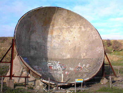
All of which brings me to the idea of sound mirrors.


Musicalizing a weather system through landscape architecture.
BLDGBLOG here proposes a series of sound mirrors to be built in a landscape with regular, annual wind phenomena. A distant gully, moaning at 2am every second week in October due to northern winds from Canada, has its low, droning, cliff-created reverb carefully echoed back up a chain of sound mirrors to supply natural soundscapes for the sleeping residents of nearby towns.
Or a crevasse that actually makes no sound at all has a sound mirror built nearby, which then amplifies and redirects the ambient air movements, coaxing out a tone – but only for the first week of March. Annually.
Landscape as saxophone.


It’s a question of interacting with the earth’s atmosphere through human geotechnical constructions. Through sound mirrors.
What you’d need: 1) Detailed meteorological charts of a region’s annual wind-flow patterns. 2) Sound mirrors. 3) A very large arts grant.
You could then musicalize the climate.
With exactly placed and arranged sound mirrors atop a mesa, for instance, deep inside a system of canyons – whether that’s in the Peak District or Utah’s Canyonlands National Park – or even in Rajasthan, or western Afghanistan – you could interact with the earth’s atmosphere to create music for two weeks every year, amplifying the natural sounds of seasonal air patterns.
People would come, camp out, check into hotels, open all their windows – and just listen to the landscaped echoes.


A few questions arise: in this context, does Stonehenge make any sounds? What if – and this is just a question – it was built not as a prehistoric astronomical device but as a *landscape wind instrument*? You’d be out there wandering around the Cotswolds, thinking oh – christ, it’s 5000 years ago and we’re lost, but: what’s that? I hear Stonehenge… And then you locate yourself.
Sonic landmark.
This raises the possibility of building smaller versions of these sound mirrors in urban neighborhoods so that, for instance, Berlin’s Prenzlauer Berg sounds different than Mitte, which sounds different than Kreuzberg – which sounds different than South Kensington, which is different than Gramercy Park… Etc.
You’d always know which district of the city you were in – even which city you were in, full stop – based on what the wind sounded like.
(Which reminds me of another idea: that, to attract people to a city without much going for it, you could *flavor the water supply*: make it taste like Doritos, for instance, and then sell that on huge billboards: buy your new home in Detroit, the water tastes like Doritos… the water tastes like tofurky…).
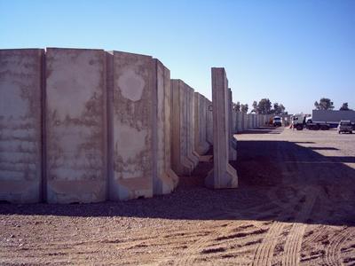
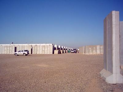
Second: is there a sonic signature to the US occupation of Baghdad? And I don’t mean rumbling Hummers and airplane engines, I mean what if all those Bremer walls –


– generate sounds during passing wind storms? All the American military bases of Iraq moaning at 3am as desert breezes pass by.
What does the occupation *sound like*?
A sonic taxonomy of architectural forms could begin…

Geomagnetic harddrive

In her recent biography of Sir Christopher Wren – whose towers, domes and steeples appear in the image above – Lisa Jardine describes how she discovered that the London Monument, designed in 1677 by Wren and Robert Hooke together, is actually “a unique, hugely ambitious, vastly oversized scientific instrument” that uses “strategically placed vents and vantage points” to function as a multi-purpose observation deck and lab for measuring atmospheric pressure.

While I was living in Berlin a few years ago, it struck me once that the U-Bahn system could pass, in its own way, for a different kind of “hugely ambitious, vastly oversized scientific instrument” – before I realized, of course, that the Tube, the Metro, the NY subway, etc. – the Beijing underground, Prague, Rome and so forth – all of them could pass for such “scientific instruments.”

In other words, those buried urban routes, with all their circuits linked and cross-connected into electrically mechanized networks that passed through mineral deposits and solid bedrock – including the various branches of late-night service that maintained more or less perpetual motion, humming and soaring through manmade canyons beneath parks and plazas and apartment blocks, as if to imply that the global geotechnical industry had been taken over by Athanasius Kircher


I realized that, in all that tumult of foundations and energy, you could, if you wanted to, listen for the subtle, cello-like moan of distant trains; and it occurred to me that the whole system, the entirety of the Berlin U-Bahn, could pass for a working model of the universe. A sonic model, at the very least, of the so-called Cosmic Microwave Background Radiation. A vaulted hum, reverbing back and through itself beneath the city.

Or – and this next idea is only slightly less ridiculous, for you cynics out there – it occurred to me that if the U-Bahn system could somehow be hooked up to massive, earth-anchored magnets, and made, therefore, to produce a magnetic field of its own, that you could transform all of Berlin into a geomagnetic harddrive.

As a sail traps the wind, a planetary harddrive would use geomagnetism.

Provided constant motion on behalf of the trains, I thought, and given absolutely gigantic magnets of the right polarity and location, Berlin could start producing its own magnetic field – which meant that any city with a subway could be transformed into a harddrive. Harddrive London. Harddrive Beijing.

Harddrive Moscow.

Of course, it’s obvious even to me that you’d have to do quite a lot more than just bury some magnets underground in order to transform a city into a harddrive – you’d need a shovel, for instance, and perhaps some strong anti-manic drugs; but my point is that if Christopher Wren could build a tower that simultaneously memorialized the Great Fire of London even as it acted as a scientific device, then perhaps you could turn urban infrastructure itself into a kind of working scientific apparatus.

You could turn all of Berlin into a geomagnetic harddrive.

Lunar urbanism 3, or: the radically non-terrestrial

The housing bubble has become literally astronomical lately, as privately-owned plots – no less than *three and a half million* of them – have been auctioned off on the moon. Yes, the moon. That’s America’s moon.


In reality, however, such plots have been on the market for decades: there’s “a loophole in the 1967 United Nations Outer Space Treaty. Although no country or government can lay claim to extraterrestrial land, it makes no mention of individual or corporate ownership. Plots have been put up for sale ever since.”
So who else but the BBC has stepped into the property-rights fray this past Friday with some helpful lunar construction advice: first, search out “sites with a good supply of ilmenite… to extract oxygen, hydrogen and helium”; then “use lunar rocks as building supplies” because “it is so costly to lift even an extra kilo of steel into space”; finally, stay “on the far side of the moon” with your old Pink Floyd records and safely avoid unfiltered solar radiation.
Sound good? Then contact Dennis Hope, the “US entrepreneur” responsible for selling the 3.4 million private plots mentioned above – and the man behind text-messaging the moon. “Mr. Hope predicts [that there will be] moon-based colonies within 12 years, and [he] is a key investor in the TransOrbital project, which aims to launch the first private commercial flight to the Moon at the end of the year.” That’s less than 4 months from now, but hey…
Mr. Hope, I suppose, must hurry, because the moon is “open for business” (TransOrbital’s actual slogan). Indeed, they’ve already got at least one rival: “the Kennedy II Project, a private venture to establish a permanent, self-supporting community by the end of the decade.” Lunar urbanism redux.
And you can also buy a plot on Mars…
In this context, of at least passing relevance is the work of Constance Adams, one of National Geographic’s 2005 Emerging Explorers, and a self-proclaimed “Space Architect.” In a 2002 lecture Ms. Adams delivered at the Architectural League – entitled “Space Architecture After *2001*” – she discussed architectural life in zero g’s.


Adams has been working on “[t]wo initiatives in recent years,” to assist with life in deep space: “the Bio-Plex and TransHab projects.” Both “have been undertaken with the express goal of solving… problems of metabolism and choreography in space habitats. The two projects are part of… a planned trip to Mars… During transit, the astronauts will live in the TransHab module. On Mars they will live in the robotically landed Bio-Plex habitation modules.”
The biomimetic TransHab module “is revolutionary in two ways. The first is that it is the first spacecraft to feature an endoskeletal construction. The module consists of a layered Kevlar inflatable shell, which performs insulating and protective functions, supported by a robust yet lightweight structural ‘skeleton.'”
As but one bio-structural example, NASA describes how microorganisms can grow cytoskeletons made from “filaments [that] meet in triangular structures resembling a geodesic dome – an example of tensegrity.” (The pull-down menu on that last link has some *great* stuff on “tetrahedral spaceframe weaves” and “extended magnetic arrays,” for starters).


[Those images are of tensegrity sculptures by the supremely talented Kenneth Snelson].
Elsewhere, Constance Adams explicitly alludes to the influence that skeletal evolution in living organisms has had on her architectural designs. She explains that “the big moment [in structural biology] is when the first creature develops an endoskeleton such as we have, thus separating the job of support from protection and permitting an almost infinite field of possibilities for variance and differentiation.” This provides her with an architectural metaphor – and there you go.
But this “infinite field of possibilities for variance and differentiation” is therefore not just architecturally liberating – it is biologically generative. NASA, aware of this, already has a deep space biology program in place to study the chemical, genetic, and macro-anatomical structures of living organisms. Why? To learn who – or *what*, I suppose – might survive in radically non-terrestrial environments. This is the exuberantly named field of astrobiology.


[For an interestingly Warholian presentation of the famed Miller/Urey experiment – in which a lightning chamber was used to generate amino acids from a mixture of inorganic chemicals – see this article from Astrobiology Magazine].
To limit myself to questions of architecture and urbanism, however, I’ll stop here and refer anyone who wants to know more about inhabiting other planets (specifically Mars) – or anyone who just wants to see cool, interactive animations – to the website Explore Mars Now – which also featured in nothing other than the second BLDGBLOG entry ever published (oh, those were the days…).

Artificial island for archipelago New York

“Creating a new island in the middle of New York City doesn’t require a landfill, just a little ingenuity. For nine days in September [2005], a 48-foot tugboat towing an ‘island’ on a 30-by-90 foot barge will partially circumnavigate Manhattan on the Hudson and East rivers.” Ritual circuits, or: plate tectonics as readymade.


The landmass, an idea by Robert Smithson, will temporarily add a new island to archipelago New York: “the flat-deck barge will hold earth, shrubs, rocks and seven specimens of trees native to the region that will rise 30 to 35 feet. Smithson drew the concept for ‘Floating Island to Travel Around Manhattan Island’ in 1970, but budget and permit issues derailed the plan’s realization, and he died in a plane crash three years later. [Could this, indeed, have been Smithson’s last, albeit suicidal, earthwork: ‘Fiery Dent in Earth’s Surface’…? ‘Artist’s Disappearance into the Planet at High-Speed’…?] The project, budgeted at around $150,000, is a collaboration of the Whitney Museum of American Art and New York-based art group Minetta Brook, and will run from September 17 to 25, after which the trees will be moved to a permanent island and replanted in Central Park.”
Surely they’ll be planted in the outline of an island…?
Next up: BLDGBLOG announces a Manmade Continent to Travel Round the World. Stay tuned…

A miniature city waiting for attack

“Tucked away in the hills north of San Luis Obispo is a miniature city waiting for attack. Concrete buildings with courtyards hug the grassy slopes, yards away from a 40-foot sniper tower and shooting ranges. They’re part of the newly renovated urban assault training complex at Camp San Luis Obispo, which prepares California National Guard members for fighting in close quarters overseas.”
This specific “urban assault training complex” is not at all unique, however, as an earlier post on BLDGBLOG has already explored. What’s interesting is the way that these particular buildings are *designed* and *cinematized*: “Three small buildings at the complex are modeled after traditional Middle Eastern homes, complete with walled courtyards” – architectural ornament as target criteria. Adolf Loos would be proud. Within this artificial Marrakech, or Baghdad 2.0 – or a kind of Mini Me, Tehran-style – “[s]oldiers practice storming the buildings and shooting short-range plastic bullets at mechanized decoys as their commanding officers record the attack with video cameras.”


(This is a photo of “a mock interview” – or media as extension of the architectural war environment. [And is that a man or a woman holding the camera…?]).
J.G. Ballard, from *The Atrocity Exhibition*: “war can be seen as a limited military confrontation with strong audience participation via TV and news media, satisfying low-threshold fantasies of violence and aggression.”
Heavily-armed urban film production units temporarily inhabiting simulated cities: it’s all in a day’s work if you’re discussing what’s known as MOUT.


“Urban areas are expected to be the future battlefield,” according to globalsecurity.org, “and combat in urban areas cannot be avoided. The acronym MOUT (Military Operations on Urbanized Terrain) is defined as all military actions that are planned and conducted on a terrain complex where man-made construction affects the tactical options available to the commander.” These are “the advantages and disadvantages urbanization offers”.
War, urban design, and “terrain complexes”: it’s armed men running through abstract environments.


MOUT, indeed, is “the future of warfare,” according to the United States Army War College. The battlefield of future hostilities, as stated by the War College’s own journal, “‘lies in the streets, sewers, high-rise buildings, and sprawl of houses that form the broken cities of the world.'” Broken cities: Philadelphia, Los Angeles, Fallujah, Slough.
In fact, Mike Davis writes, MOUT – or the military’s pursuit of urban design by other means – is indispensable to “Washington’s ability to dominate what Pentagon planners consider the ‘key battlespace of the future’ – the Third World city.” Rather than learn lessons of pedestrianization, or how to control sprawl, or even what radically mixed-use zoning really looks like, or perhaps the dire need for stricter environmental safety regulations, the “Third World city” apparently offers only one true lesson: how to attack.


This is “the Pentagon as global slumlord”.
The First World military, Davis continues, is “unprepared for protracted combat in the near impassable, maze-like streets of the poverty-stricken cities of the Third World. As a result, the four armed services, coordinated by the Joint Staff Urban Working Group, launched crash programs to master street-fighting under realistic third-world conditions.”
Producing so-called “realistic third-world conditions,” of course, requires constructing decoy villages on rural U.S. military bases, as well as urban assault training complexes – complete with Middle Eastern ornaments – in the hills outside San Luis Obispo. Call it the new International Style, or perhaps Military Arabesque.
Or just call it “miniature cities waiting for attack.”


(Sorry that image is so small – I’m not trying to be over-literal).
As the *Stars & Stripes* itself declares, the world’s largest military is now running “various scenarios in ‘Combat Town’ as part of a Training in an Urban Environment (TRUE) exercise”. The terminology here astounds: “various scenarios in ‘Combat Town'” could surely be the title of a new short story collection by Don DeLillo, even as “Training in an Urban Environment (TRUE)” could be an effective new moniker for a Nike fitness campaign – yet they’re both part of the US military’s rhetorical framing of our combat-prone, global future.
Cities, as they exist in First World military simulations, are virtualized yet further through inclusion in Department of Defense video games. See, for instance, *Urban Resolve*: “Developed by the U.S. Joint Forces Command, or JFCom, a division of the Department of Defense, the $195,000 program is a combat simulation on a massive scale. (…) In other words, it’s one part *Risk*, one part *The Sims* and one part raw supercomputing power. It’s also the tool that could one day give the U.S. military the upper hand in urban conflicts akin to the ones currently taking place in Iraq.”
“[U]sing concepts borrowed from artificial intelligence research,” *Urban Resolve* functions somewhere between high-tech city planning assistant and future warfare prediction device, “helping military leaders determine which types of sensors – CIA agents, spy planes, listening devices and so on – are best for tracking enemy forces that are hiding in a modern city.” Or, surveilling those city-dwellers virtually and in advance, using AI – so that you can cut off their power and kill them.
Such computer simulations are increasingly the norm “in a growing number of defense exercises. With ever-more-sophisticated simulation and modeling technology, the military today can mix and match real tanks, planes and ships with forces that exist only on computers – and those located in virtual training environments, such as pilots in flight simulators thousands of miles away.” The First World military meets the entertainment industry – the so-called “military-entertainment complex” – via urban design and building contractors. But the phrase, “virtual training environments,” as we’ve seen, can also be applied to modular, fake-Arabesque war villages built in the hills of California.
The Disneyfication of urban conflict; the Epcot Center of war.
This connection between architectural contracting and overseas military conflict can be glimpsed elsewhere. Return, for instance, to *Stars & Stripes*, where we read that, “[w]ith the ability to construct buildings and excavate land, the 94th Engineer Battalion seemed like the ideal choice for the mission at hand” – which, specifically, was base construction in Iraq. But this Battalion is the “ideal choice” for an overseas combat zone because it can “construct buildings and excavate land.” Architectural contracting, or: urban war by other means.
See also the Virginia-based company, Anteon, a strange cross between Archigram and Dick Cheney. Anteon designs and manufactures modular training environments for law enforcement and military exercises, including “a mobile, reconfigurable MOUT training facility. Mobile MOUT is a comprehensive solution, providing a facility that would give units a modular, transportable training system, featuring:
• Fast set-up and disassembly…
• Various building sites configurations…
[and]
• Changeable interior room configurations”
– thus my comparison to Archigram.
Modular urban design: instant cities in the Third World desert, underwritten by the Pentagon.
A series of questions arises: is modular architecture’s future not to be found within overproduced, avant-garde grad student projects, but in the now ubiquitous Third World battlefields that seem destined to grow in size and number? Is Third World urbanization a military (or refugee) phenomenon? If so, does global geopolitical conflict produce bull markets in modular architecture?
And is the U.S. Department of Defense actually leading the way when it comes to fulfilling predictions made so long ago by Archigram: that the cities of the future will be instant; they will be air-lifted in to the middle of nowhere; they will thrive in a state of continually incomplete assemblage; etc.?


Is the urbanism of the future *military urbanism*?


More images of simulated war-cities and their armed inhabitants from the virtualized future-present can be found here.

(This post briefly updated, 25 August, and later posted to nettime).

Interactive Nolli map

Giambattista Nolli’s 1748 Map of Rome –


– “is widely regarded by scholars as one of the most important historical documents of the city ever created. This project is a collaborative exploration of the exquisite Nolli engraving, through its historic significance and contemporary application.”


In other words, two professors at the University of Oregon have made it interactive: you can focus on the Tiber, on the city walls, zoom in, zoom out, switch to a satellite view…
Plus this guide to Nolli’s cartographic symbols:


Symbols used thusly:


(Nolli link originally spotted on Archinect; also see Pruned).
In this context, however, I can’t resist putting up some of Piranesi’s Rome images, as I have a somewhat irrational love for Piranesi: