1)New York Times: “From the city that has banned cars from broad swaths of Broadway and put picnic tables in Times Square, here comes another great reshaping of New York’s streetscape. The Bloomberg administration is moving ahead with what amounts to a radical, river-to-river reimagining of another major corridor: 34th Street.”
Automobiles would be banned on the block between Fifth Avenue and Avenue of the Americas, creating a pedestrian plaza bookended by Herald Square and the Empire State Building. The result would be a street effectively split in two.
2)American Society of Landscape Architects: “Certainly, it’s very difficult to preserve an evolving landscape. We live in a transitional world and have to adapt to our own constants. Sometimes it’s very difficult to imagine that something will remain exactly the same. We had to define heritage categories that are intrinsically evolving. We’re trying at UNESCO to change our approach a little bit to create a vision of how heritage can be seen in a transitional world.”
3)Archaeology: “The stone city of Nan Madol, in Pohnpei, one of the Federated States of Micronesia (FSM), consists of 92 man-made islands built on a coral reef at the edge of a mangrove swamp. The buildings of this mysterious 1,000-year-old site, which was the ceremonial and political seat of an ancient dynasty, are made of stacks of cut stone “logs,” each weighing up to 50 tons. Today, issues of ownership and sovereignty hold up plans to rehabilitate Nan Madol and make it eligible for a UNESCO World Heritage designation.”
[Image: A giant battery grows in Texas; image courtesy of Popular Science].
5)Popular Science: “An aging transmission line built in 1948 is the only link between the U.S. power grid and the little city of Presidio in West Texas. So Presidio has invested in a single huge battery that can power the entire town and serve as emergency backup for the frequent outages caused by the line going down.”
6)Daily Telegraph: “Archaeologists in Italy have unearthed the remains of a 6th century BC temple-style building complete with detailed assembly instructions which they have likened to an Ikea do-it-yourself furniture pack.”
7)BBC: “The Nottingham Caves Survey… will use a 3D laser scanner to produce a three dimensional record of more than 450 sandstone caves around Nottingham from which a virtual representation can be made.”
The area which now makes up Nottingham city centre was once known as Tiggua Cobaucc, which means “place of caves.” The caves date back to the medieval period and possibly earlier. Over the years they have been used as dungeons, beer cellars, cess-pits, tanneries and air-raid shelters.
8a) “The Falmouth Convention is a three-day conference in an unconventional form… Conceived as an international meeting of artists, curators and writers to explore the significance of time and place in relation to contemporary art and exhibition making, it has been planned to respond to the situation in Cornwall and other such dispersed, rural areas.”
8b) “Described in the eighteenth century as the ‘richest square mile in the old world,’ the Gwennap Mining District will be the setting for a field trip led by the Falmouth-based arts organisation Urbanomic, ‘a journey into an historical process that assembled the powers of geology, mechanics, hydraulics, mineralogy and metallurgy, salvation and combustion, steam and capital into a mighty, infernal machine that traumatised the Cornish landscape and kick-started the industrial revolution.’”
Visiting lesser-known sites where these components interacted and evolved during the height of the mining trade in Cornwall, the field trip will discover what lies beneath the tourist emblem of the abandoned engine-house. With the guidance of rogue scientists, agrosophists and geophilosophers, it will uncover “the complexities of subterranean poetics and aesthetics, and confront the industrial behemoth that made the earth scream.”
9)Popular Science: “While three-dimensional printing has come a long way, engineers still struggle with fabricating objects smaller than a quarter,” but “researchers have hit upon a technique that could produce any number of microscopic medical or mechanical devices through folding, rather than layered printing.”
10)National Geographic Channel: “Take an inside look at what may be the toughest disciplinary tool in the U.S. prison system: solitary confinement.”
Extra Credit: “The European Union has declared travelling a human right, and is launching a scheme to subsidize vacations with taxpayers’ dollars for those too poor to afford their own trips.”
The Strato Lab project was a manned, high-altitude balloon project from the 1950s that ascended with its crew above 80,000 feet several times. The pilots performed scientific observations there, including taking observations of Venus through an on-board telescope.
The specific experiments interest me less, however, than the architectural possibilities of inhabited balloons in the stratosphere. The Strato Lab was a kind of sky-throne, regal and airborne over the continents below.
Historian Gregory P. Kennedy has the story over on his website; he includes technical details about how the Strato Lab worked, as well as some thoughts about its position in design history.
Strato Lab had two inward opening hatches mounted in flat frames. Having two hatches made normal entry and exit easier and facilitated rapid exit in case of an emergency. Simple air pressure sealed the hatches. Within the cabin, a pressure equivalent to 17,000 feet was maintained. When the balloon ascended beyond that altitude, the pressure difference between the inside and outside atmospheres forced the hatches against their frames. A silicone O-ring around the outer diameter of each hatch created a pressure-tight seal. During descent, the hatches opened automatically.
The lab was also backed up by a “64-foot diameter nylon cargo parachute,” and, if that should fail in addition to the balloon, the crew members themselves had their own emergency chutes.
“Strato Lab retained the configuration and certain design elements of balloon gondolas of the 1930s,” Kennedy writes. “Thus, it bridged the gap between pressurized gondola designs of the 1930s and modern spacecraft.”
All of this takes on a further, slightly different air of possibility when seen in the context of recent questions about the future of air travel in light of Iceland’s Eyjafjallajokull volcano; if the Katla volcano—ten times the size of Eyjafjallajokull and less than six miles away from it—were to erupt next, for instance, the European airline industry as it currently exists could be put out of business for weeks or months at a time. The New York Times took this as a cue to ask what might be next: high-speed rail, dirigibles, airships…? And that, of course, is if a future supervolcano doesn’t simply cause extinction.
But perhaps high-altitude—and “super-high-altitude“—balloons could be both destination and route: airborne rooms enthroned atop wind systems accessible to civilians for the first time, future platforms for housing at the forecourt of the sky. You build a pressurized village of linked pods, spanning acres—the architectural legacy of Ant Farm—on some land in Nebraska; the final step clips oversized polyethylene balloons to roof-hooks, and then there you go: hauling your project to its rightful site, skybound, where an emerging race of balloonists will evolve massive lungs 95,000 feet above the Great Plains.
As of roughly 16 hours ago, the Archigram Archival Project is finally online and ready to for browsing, courtesy of the University of Westminster: the archive “makes the work of the seminal architectural group Archigram available free online for public viewing and academic study.”
[Image: “Proposal for a series of inflatable dwellings as part of an exhibition for the Commonwealth Festival, located in the lodge of Cardiff Castle,” by Archigram/Ron Herron].
Even at their most surreal, it feels as if Archigram did, in fact, accurately foresee what the architectural world was coming to. After all, if Chalk & Co. had built the things around us, there would be electricity supplies in the middle of nowhere and drive-in housing amidst the sprawl; for good or for bad, we’d all be playing with gadgets like the Electronic Tomato, that perhaps would not have given the iPhone a run for its money but was a “mobile sensory stimulation device,” nonetheless. We might even live together on the outer fringes of “extreme suburbs,” constructed like concentric halos around minor airports, such as Peter Cook’s “Crater City,” an “earth sheltered hotel-type city around central park,” or “Hedgerow Village,” tiny clusters of houses like North Face tents “hidden in hedgerow strips.”
There would be temporary, inflatable additions to whole towns and cities; pyramidal diagrid megastructures squatting over dead neighborhoods like malls; dream cities like Rorschach blots stretched across the sky, toothed and angular Montreal Towers looming in the distance; plug-in universities and capsule homes in a computer-controlled city of automatic switches and micro-pneumatic infrastructure.
At its more bizarre, there would have been things like the Fabergram castle, as if the Teutonic Knights became an over-chimneyed race of factory-builders in an era of cheap LSD, reading Gormenghast in Disneyworld, or this proposal “for technology enabling underwater farming by scuba divers, including chambers, floats and tubes for walking and farm control.” After all, Archigram asked, why live in a house at all when you can live in a submarine? Why use airplanes when you can ride a magic carpet constructed from shining looms in a “‘reverse hovercraft’ facility where a body can be held at an adjustable point in space through the use of jets of air”?
It might not be architects who have realized much of this fever dream of the world to come, but that doesn’t mean that these ideas have not, in many cases, been constructed. Archigram spoke of instant cities and easily deployed, reconfigurable megastructures—but the people more likely to own and operate such spaces today are Big Box retailers, with their clip-on ornaments, infinitely exchangeable modular shelving, and fleeting themes-of-the-week. Archigram’s flexible, just-in-time, climate-controlled interiors are not a sign of impending utopia, in other words, but of the reach of your neighborhood shopping mall—and the people airdropping instant cities into the middle of nowhere today are less likely to be algorithmically trained Rhino enthusiasts from architecture school, but the logistics support teams behind Bechtel and the U.S. military.
Another way of saying this is that Archigram’s ideas seem unbuilt—even unbuildable—but those ideas actually lend themselves surprisingly well to the environment in which we now live, full of “extreme suburbs,” drive-in everything, KFC-supplied army bases in the middle of foreign deserts, robot bank tellers, and huge, HVAC-dependent wonderlands on the exurban fringe.
The irony, for me, is that Archigram’s ideas have, in many ways, actually been constructed—but in most cases it was for the wrong reasons, in the wrong ways, and by the wrong people.
In any case, what was it about Archigram that promised on-demand self-transformation in an urban strobe of flashing lights but then got so easily realized as a kind of down-market Times Square? How did Archigram simply become the plug-in units of discount retail—or the Fun Palaces of forty years ago downgraded to Barnes & Noble outlets in the suburbs? How did the Walking City become Bremer Walls and Forward Operating Bases, where the Instant City meets Camp Bondsteel?
Archigram predicted a modular future propelled by cheap fuel, petrodollars, and a billion easy tons of unrecycled plastic—but, beneath that seamless gleam of artificial surfacing and extraterrestrial color combinations was a fizzy-lifting drink of human ideas—as many ideas as you could think of, sometimes imperfectly illustrated but illustrated nonetheless, and, thus, now canonical—all of it wrapped up in a dossier of new forms of planetary civilization. Archigram wasn’t just out on the prowl for better escalators or to make our buildings look like giant orchids and Venus Flytraps, where today’s avant-bust software formalism has unfortunately so far been mired; it wasn’t just bigger bank towers and the Burj Dubai.
Instead, Archigram suggested, we could all act differently if we had the right spaces in which to meet, love, and live, and what matters to me less here is whether or not they were right, or even if they were the only people saying such things (they weren’t)—what matters to me is the idea that architecture can reframe and inspire whole new anthropologies, new ways of being human on earth, new chances to do something more fun tomorrow (and later today). Architecture can reshape how we inhabit continents, the planet, and the solar system at large. Whether or not you even want inflatable attics, flying carpets, and underwater eel farms, the overwhelming impulse here is that if you don’t like the world you’ve been dropped into, then you should build the one you want.
In any case, the entire Archigram Archival Project is worth a look; even treated simply as an historical resource, its presence corrects what had been a sorely missing feature of online architecture culture: we can now finally link to, and see, Archigram’s work.
(Note: Part of the latter half of this post includes some re-edited bits from a comment I posted several months ago).
As the spring semester comes to an end, and as this past Friday afternoon brought with it a guest lecture from historian James Fleming, I thought I’d offer a quick look back at some texts—mostly books—that were of particular use during the Glacier/Island/Storm studio up at Columbia.
[Image: A hike through the South Downs, photo by the author].
I should add, though, that the following books were not assigned reading—they simply came up as frequent points of conversational reference during individual desk-crits. These were also all in addition to technical readings, done on a per-project basis, such as industry reports on maritime pharmacology, the engineering and construction of offshore structures, the ferroelectric potential of ice, surveys of atmospheric fog- and dew-harvesting techniques in southern England, and the full text of the U.N. Convention on the Prohibition of Military or Any Other Hostile Use of Environmental Modification Techniques.
In turn, those were in addition to several documentary films, such as Owning the Weather, Drifting Station Alpha, and The Reef Builders; which were also on top of a field trip to the Lamont-Doherty Earth Observatory, a visit from marine biologist Thomas Goreau, a daylong symposium looking at Glacier/Island/Storm outside of its more explicit architectural contexts with the authors of Mammoth, Quiet Babylon, and Edible Geography, and a long list of individual student interviews with experts in the field. These took place during overseas trips to destinations as far as Bali, Morocco, the Blue Hole of Belize, the South Downs, and the Swiss Alps. It’s been an awesome semester, at least from my perspective, and I’m sorry to see it go.
In any case, the following list includes texts that came up across more than one project, at multiple times during the semester for various reasons. As such, they were particularly useful in helping to generate design ideas. In no particular order:
1) “The Climate Engineers” by James Fleming. Fleming’s article is an excellent survey of the history—and possible political future—of weather-control efforts and climate-modification technology, mostly in a military context. “Assume, for just a moment,” Fleming writes, “that climate control were technically possible. Who would be given the authority to manage it? Who would have the wisdom to dispense drought, severe winters, or the effects of storms to some so that the rest of the planet could prosper? At what cost, economically, aesthetically, and in our moral relationship to nature, would we manipulate the climate?” His forthcoming book, Fixing the Sky: The Checkered History of Weather and Climate Control sounds fantastic, and it extends that research.
2)Alternative Guide to the Isle of Portland by Shin Egashira and David Greene. I bought this book—a pamphlet, really—back in 1998, and I’ve held onto it ever since, even taking it with me on this (still ongoing) year-plus global trip. Exploring the island of Portland—from which much of London’s architectural rock was once quarried, turning the island’s profile into a negative graph of London’s expansion—from the perspective of investigative landscape design, Egashira’s and Greene’s students covered the terrain in architectural devices, machines, and mechanisms that could record wind speed, coastal barometry, island seismology, water levels, and much more (as well as simply demonstrate carpentry skills).
3)The Frozen Water Trade by Gavin Weightman. I first became aware of this book through an old reference on Pruned, but only managed to read it this past winter. A historical look at the early days of ice-harvesting from the surfaces of frozen ponds across New England—after which great cubes would be preserved in ice houses and in the hulls of ships, insulated with saw dust, and sold to markets as far away as India. The economics, technicalities, and strange cultural inspirations behind the ice-harvesting industry are genuinely fascinating. “Those who could afford it,” Weightman explains, “had a fresh block of ice delivered daily, for which they paid a weekly or monthly subscription”—and thus we have the deterritorialized surfaces of frozen ponds, rearranging themselves around the world by monthly subscription.
4)When the Rivers Run Dry by Fred Pearce. This book seemed like something I’d simply file away on my bookshelf for another day, but I stormed through it in less than three nights after letting myself take on the first few pages. Absurdly interesting, and almost impossible to put down, this book about freshwater and its dwindling global presence is so full of interesting material that I could refer to it again and again. Fog nets in South America, dew ponds in Sussex, desert raincatchers, and underground cisterns in China, by way of Iranian qanats, freshwater politics in the U.S. southwest, and polluted irrigation systems in India, cross with disappearing glaciers, the Amazon river, the subsidized economies of hydroelectric projects, and much more, to make a fantastic book. The author, Fred Pearce, also blogs for the Guardian.
5)Sand by Michael Welland. Welland’s book—which I have been meaning to review at great length all Spring and will finally be doing so soon—is equally fantastic. The torsional geometry of sandstorms, dune physics, military geology labs, sand forensics at murder scenes, “sand smuggling,” and large-scale anti-desertification projects in the Sahara meet high-grade silicon mines and granular deposits on Mars in Welland’s informal narrative that goes all the way around (and off) the planet. Welland, too, has a blog, Through the Sandglass, which is well worth checking out.
6)-arium: Weather + Architecture by Neeraj Bhatia and J. Mayer H. Published midway through the semester, Bhatia’s and Mayer’s book includes several student projects from a recent weather-design studio in Toronto, as well as the editors’ own original research into climate-modification and its possible urban futures. Bhatia’s short history of thermally regulated interior environments, and what he calls “the crisis of created climates,” is a highlight. Bhatia, of course, is co-author of the blog InfraNet Lab, whose four authors collectively participated in our Glacier/Island/Stormblog week back in February.
7)Subnature by David Gissen. Gissen’s book has already come up several times, to positive review, here on BLDGBLOG and presumably needs little introduction to long-term readers—but it’s a memorably wide-ranging look at all those other presences in the city that urbanists tend to overlook: puddles, dust, dirt, rats, weeds, and car exhaust, to name but a few. Gissen’s history of the tunnel-ventilation infrastructure of Manhattan was of particular relevance this term, as a few students and I looked briefly at the possibility of weather systems generated underneath the metropolis, as air pressure builds, moves, and dissipates throughout sewers, subway tunnels, and cross-island links. What weather-modification possibilities exist below the earth’s surface? Speculative rhetorical questions aside, Gissen’s book is valuable reading for anyone interested in the flipside of the modern city.
[Image: Holland Tunnel exhaust tower, ventilating the Manhattanite underworld; photo via SkyscraperPage.com].
8)Seven Partly Underground Rooms and Buildings for Water, Ice, and Midgets by Mary-Ann Ray. Mary-Ann Ray’s old Pamphlet Architecture installment is still one of my favorites. As much an archaeological handbook as it is an architectural guide, Ray’s pamphlet takes us into the ruins of underground spaces around Italy, including helical stairways, spherical ice-storage facilities “with as little surface area as possible,” and vaulted secret passageways for midgets.
9)Augmented Landscapes by Smout Allen. Smout Allen’s work bridges landscapes, watersheds, continents, and villages, connecting architectural design to the mobile terrains of receding coastlines, wind-blown fens, and drainage canals. “In this Pamphlet,” the authors write, “we discuss five design cases.
In each the physicality of the site and the processes of environmental transformation are exploited—the intrinsic features of the landscape, the force of nature, geography, climate, geology, and land use are all scrutinized. The resulting architectural interventions respond to their dynamic and fluxing territories. The ephemeral character of the environment is reflected in the solidity of the artifacts that inhabit it as they take on a local specificity and lend to their surroundings a sense of nature illuminated.
You can read more about Smout Allen’s work courtesy of an article in the April 2010 issue of Blueprint Magazine.
10)Mont Blanc: A Treatise on its Geodesic and Geological Constitution by Eugène Viollet-le-Duc. Last but not least, Viollet-le-Duc’s amazing hybrid architectural/geological analysis of the tectonic structure of Mont Blanc and its glaciers offered us several beautiful insights into the structural properties of ice flows and how they might be of interest in the context of architectural design.
[Images: From Mont Blanc by Eugène Viollet-le-Duc].
Quoting at great length from a paper by architectural historians Martin Bressani and Robert Jan van Pelt:
Viollet-le-Duc’s work on Mont Blanc introduces a new edge to geological discourse in architecture as compared to the painterly outlook of [John] Ruskin. Now, observations of tectonic forms not only served to see nature intensely but also, and mainly, to identify a structural logic to its complex morphology. A basic principle thus organizes Viollet-le-Duc’s analysis of the great massif: The apparent chaos of its outline is only an illusion, as “laws have ordered these forms and determined the great crystalline system.” Viollet-le-Duc’s book is essentially a description of the process of formation of Mont Blanc, using a set of fascinating drawings and diagrams as if he had been present at the time of its genesis. The book’s opening chapter confidently illustrates the initial upheaval that generated the massif: An expanded mass of soft granite (protogine) below the earth’s thick surface erupted through the crystalline crust above, producing a domical rock formation sprouting out of a buttonhole-shape slit. As it slowly cooled and crystallized, this gigantic mass of granite progressively shrank and retreated. According to Viollet-le-Duc, the subtraction process followed a very precise rhombohedral prismatic pattern consistent throughout the whole. Mont Blanc thus acts as one huge crystal formation—every edge, every peak and aiguille follows a geodesic structure. The pattern creates a network of cells, a type of formation that Viollet-le-Duc found also at the micro level in glacial formation. This hexagonal configuration, based upon the equilateral triangle, proved the most fundamental and consistent principle of organization within Viollet-le-Duc’s late writings and architecture.
Within both glaciers and large-scale rock formations, in other words, we can find formal analogies for human architectural constructions—a geometry and order to both rock and ice. Coming round nearly full circle, then, geologist Michael Welland, whose book Sand is mentioned above, wrote a blog post exploring Viollet-le-Duc’s Alpine investigations, also mentioning a kind of geological novella that Viollet-le-Duc wrote shortly before his death.
• • •
Again, that’s by no means all of the material that we looked at this term, but it does give a fairly good list of the textual, historical, scientific, and architectural influences that came up repeatedly during the course.
In his recent book The Lost Books of the Odyssey—an “ingeniously Borgesian novel that’s witty, playful, moving and tirelessly inventive”—author Zachary Mason, an Artificial Intelligence researcher, fictionalizes King Agamemnon’s attempts to build a fortress underground.
Agamemnon’s choice of site, however, makes this task rather difficult: it is to be constructed in the sandy plains facing the walls of Troy.
Agamemnon wanted a fortress on the wide plain before the walls of Troy but there was nothing to build with but a few trees and an unlimited quantity of sand. Therefore (at Odysseus’s suggestion) the Greeks dug the negative image of a palace in the white plain, a convoluted warren where cascades of fine grains trickled endlessly down the walls and into the tenuous corridors irregularly shored up with masonry.
Mason describes “frequent cave-ins and sand-slides that suddenly obliterated rooms, courtiers, armories, armorers, elegists and exits.” It was, Agamemnon says to himself, both forward-operating base and future tomb.
Following the wisdom of the court geomancers it was considered impious to exhume any of the collapsed rooms and tunnels, a sin on par with looting a tomb, so when more space was needed the miners struck out into virgin ground. Thus the new underground palace evolved dendritically, sending off new shoots in all directions, sometimes opposed by unforeseen aquifers or plumes of hard rock, working around these obstacles with ant-like tenacity.
The passages multiply and deepen until the fortress “resembled a vast inverted castle, its battlements and towers soaring into the depths of the earth. Now and then a district was separated by a landslide and till the miners could reconnect them to the king’s rule they lived with their own laws and minted their own coins,” forming separate subterranean administrations, split by the logic of collapsing sand and its unpredictable granularity.
[Images: Extraordinary photographs of sand by Larry Deemer].
The architectural nature of sand grains is something discussed by Michael Welland in his own book Sand. There, Welland introduces us to the complex internal structures of sand dunes:
The weight and pressure distribution within a pile of any granular material is determined by the way in which the individual grains contact each other and distribute the stress. Quite commonly, grain shapes and sizes mean that there are microscopic chains and networks of grains that are oriented and in contact with each other in such a way that they carry most of the pressure from the weight of the material above them. These chains seem to behave like the soaring arches of Gothic cathedrals, which serve to transmit the weight of the roof, perhaps a great dome, outward to the walls, which bear the load. In a sand pile, particularly one that is confined in a container of some sort, these chains perform the same function—they carry the stress outward to the container, rather than directly downward to the base of the pile.
The idea that dunes have internal Gothic cathedrals, arranged chain-like throughout their sandy massing, is an incredible thing to consider. The amorphous mounds of the deep desert are, in fact, both structurally intricate and gravitationally complex.
Agamemnon’s fortress is thus a mathematical model of collapse—an inhabitable diagram of the forces traveling through it—bulwarked and avalanching against itself into new formations and plans. It is an architecture of dynamic materials.
[Image: A still from Inception, directed by Christopher Nolan, courtesy of Warner Brothers].
An article I meant to link to the other week takes a look at the architectural design of Christopher Nolan’s forthcoming film Inception. Being a longtime fan of Nolan’s work, going back to his debut feature, Following (which I first saw at the Edinburgh Film Festival in 1999 and which, oddly enough, starred emerging architectAlexHaw, now of Cloud fame), I have to say that I am very much looking forward to seeing this movie.
Geoff Boucher of the Los Angeles Times describes it as “Hollywood’s first existential heist movie,” offering us a preview of some of the film’s sets and spaces in the process.
[Images: A rotating hall and fight scene from Inception, courtesy of Warner Brothers].
He specifically highlights the contributions of “special effects guru Chris Corbould (the man who built the Batmobile and has worked on a dozen James Bond films),” who helped to “put a premium on an old-school approach to movie magic” in the physical production of Inception:
Corbould’s teams, for instance, built giant rotating hallways and a massive tilting nightclub set to film the startling Inception scenes when dream-sector physics take a sharp turn into chaos. One of the film’s stars, Joseph Gordon-Levitt, spent long, bruising weeks learning to fight in a corridor that spun like a giant hamster wheel.
The idea of athletically training inside “giant rotating hallways” on a film set is pretty awesome; it comes with the implication that certain combat scenes are less demonstrations of a specific fighting style than the architectural revelation of a whole new type of geometry, an unprecedented way of filling, and thus dominating, space. On the other hand, of course, Boucher is quick to point out that it wasn’t all analogue set construction and advanced balance-training:
Inception does have major computer effects: Several vivid sequences show a dream metropolis in churning calamity, a city skyline seems to fold in on itself as a dream begins to lose its shape and, unlike many Hollywood versions of dream surrealism, the scene has the look of a massive mechanical failure, not a morphing, liquid calamity. Nolan’s dreams have the sharp edges of Escher, not the syrup drips of Dalí. Architecture is a major influence on the culture of the film too with dreams that are more like blueprints than poems. That speaks to Nolan’s longtime interest in architecture. A key scene in Inception was filmed at the architecture school at University College London, where Nolan was an English major and also met his future wife and producing partner, Emma Thomas.
You can see one of those “massive mechanical failures” in the image, below, where we watch Paris rear up and crease back over on itself like some fine-tuned, mathematically exact introduction to a new, urban-scale baroque.
[Image: From Inception by Christopher Nolan, courtesy of Warner Brothers].
In any case, check out the trailer when you get a chance—while I try to work some media magic to score an interview for BLDGBLOG with Nolan and Corbould.
(It’s interesting to note, meanwhile, in the context of this post’s opening image, that Nolan grew up in Chicago—which, in tandem with that image, makes me wonder if some very, very minor part of Nolan’s architectural and stylistic interest in Japonisme—i.e. Batman as ninja in a wood-paneled dojo—wasn’t at least partially inspired by the Frank Lloyd Wright buildings scattered in and around the Chicago area; in fact, the set featured in that opening image could very well have been inspired by Wright’s Imperial Hotel in Tokyo).
If you had told me that a new science fiction novel just come out featuring a planet on which vast turbulent structures of glass move through the global atmosphere, posing a dire threat to machinery and drifting across whole continents in a kind of low-intensity storm of aerosolized crystal, I would, naively, never have assumed that such a thing might also be possible here on earth. The speculative climatology of alien worlds.
[Image: Photo by AP Photo/Brynjar Gaudi].
But, perhaps, if airplane engines are built to fly through air—i.e. not through glass, dust, rocks, or geology—today’s airplanes should be temporarily retrofitted with tunneling equipment under each wing, jury-rigged Herrenknecht machines to drill a new infrastructure of hovering tunnels through the glass-thundering skies of northern Europe.
One of many things that we’ll be looking at tonight in the Blackout seminar that I’ve been teaching over at Pratt in Brooklyn is organically generated electricity—things like virus batteries, biogeobatteries, sediment batteries, and more.
[Image: From Christopher Nolan’s film The Prestige (2006)].
By way of getting there, though, we’ll be taking a very brief look at Christopher Nolan’s under-rated film The Prestige—specifically the scene in which we see a hillside covered in giant incandescent light bulbs, none of which appear to be plugged into anything but soil and all of which are powered wirelessly by a generator located over 12 miles away.
The geological form of the mountain plateau becomes a shining grid framing our two featured characters.
[Image: From Christopher Nolan’s film The Prestige (2006)].
Although The Prestige does not suggest that this is what’s happening in this scene, what if the soil itself was powering these light bulbs? What if soil could be turned into a landscape-scale, distributed electrical device?
Awesomely, as Nature reported just two months ago, there is growing evidence to back up “a suggestion within the geophysics and microbiology communities that bacteria can grow tiny ‘wires’ and hook up to form a biogeobattery—a giant natural battery that generates electrical currents.”
Scientists have known that bacteria can create electricity when mixed with mud and seawater, and have even built microbial fuel cells around the little buggers. Now they have begun figuring out just how bacteria create electrical networks that serve as long-distance communication, at least on the microbial scale—the distances ranged up to 2 centimeters. Yet those few centimeters equal roughly 20,000 times the body size of individual bacteria.
Imagining soil itself—the ground all around us—as a giant electrical transmission network is astonishing. And, again, while there is no mention of anything like biogeobatteries and their ilk in The Prestige, the very idea that perhaps someday we could plug light bulbs directly into the soil—an organic battery coextensive with the living surface of the earth—amazes me.
And biogeobatteries are not even the only option here; there are also virus batteries.
MIT reported back in 2006 that a team of researchers had “harnessed the construction talents of tiny viruses to build ultra-small ‘nanowire’ structures for use in very thin lithium-ion batteries. By manipulating a few genes inside these viruses, the team was able to coax the organisms to grow and self-assemble into a functional electronic device.” The resulting virus batteries are tiny, but they could vary in scale “from the size of a grain of rice up to the size of existing hearing aid batteries.”
The future design possibilities are bewildering. Could deposits of virus-impregnated soil be used as electricity-storage devices in rural, off-the-grid areas?
After all, bacteria might already be “wiring up the soil,” Nature suggested three years ago. Indeed, “bacteria can sprout webs of electrical wiring that transform the soil into a geological battery,” meaning that “the earth beneath our feet might act as a gigantic circuit built by microbes to power their metabolic systems.” And you can build a soil battery yourself:
The researchers filled plastic columns with wet sand infiltrated with a nutrient compound (lactate), and allowed S. oneidensis to grow in this “fake soil.” Only the top of the column was in contact with air. Electrodes inserted at various heights up the columns revealed that, after about ten days, electrical charge was coursing up the column… threaded by a web of filaments between the bacterial cells.
I’m reminded here of the work of Philip Beesley, which often uses self-fertilizing yeast-packs, gels, and seeds to create living geotextiles. In fact, a Beesley Battery doesn’t seem at all very off: a living mat woven through the soil, generating and storing electricity based on pre-existing bacterial activity in the ground.
You infect the soil with a genetically-modified virus patented by MIT and electrical currents start to flow…
[Image: From Christopher Nolan’s The Prestige (2006)].
Perhaps someday, then, we could simply show up somewhere, in the middle of the night, surrounded by pine forests and hills, and just crouch down, push a light bulb two or three inches into the earth—
[Images: (left) An archaeologist examines soil cores. (right) Researchers plot lost roads across the grounds of Monticello. Courtesy of the Glenn A. Black Laboratory of Archaeology at IU Bloomington].
It’s hard to resist a caption referring to a “team of researchers” who have used their “electrical resistivity profiler to discover long-buried roads around the historic Virginia home” of 18th century U.S. president Thomas Jefferson. But that’s exactly what you’ll see courtesy of a recent press release from Indiana University.
Specifically, we read, a team of Indiana University archaeologists have “conducted a landscape study to find evidence of two lost roads: a ‘kitchen road’ that serviced the Monticello kitchen, and a formal carriageway that circled along the Ellipse Fence marking the edge of the East Lawn and the formal landscape in front of Monticello.”
A combination of soil cores and direct electrical data helped that team outline this otherwise lost geography at the heart of U.S. presidential history and across the original lawns of American Palladianism. Jefferson, as you might know, was an architect, one heavily influenced by the texts and buildings of Andrea Palladio. American architecture, from day one, was, in a sense, a facsimile: created, with far-reaching variations and personal stylistic quirks, based on reproduced manuscripts from Europe.
In any case, stepping back: beneath Jefferson’s lawn are lost roads.
I’m reminded here of an amazing story published two years ago in the New York Times about “ancient roads,” dating from colonial times, in the U.S. state of Vermont.
As the The New York Times explained back then, a 2006 state law gave Vermont residents a strong incentive to uncover the buried throughways in, around, and through their often quite rural towns. Indeed, “citizen volunteers are poring over record books with a common, increasingly urgent purpose: finding evidence of every road ever legally created in their towns, including many that are now impassable and all but unobservable.”
These “elusive roads”—many of them “now all but unrecognizable as byways”—are lost routes, connecting equally erased destinations. In almost all particular cases, they have barely even left a trace on the ground; their presence is almost entirely textual.
They are not just lost roads; they are road that have been deterrestrialized.
If these ancient routes can be re-discovered, however, then Vermont state law dictates that they can also be added to official town lands (and thus be eligible for some kind of federal something-or-other). Accordingly:
Some towns, content to abandon the overgrown roads that crisscross their valleys and hills, are forgoing the project. But many more have recruited teams to comb through old documents, make lists of whatever roads they find evidence of, plot them on maps and set out to locate them.
And, in what is surely one of the most interesting geographical subplots in recent newspaper publishing, we read: “Even for history buffs, the challenge is steep: evidence of ancient roads may be scattered through antique record books, incomplete or hard to make sense of.”
Like something out of the poetry of PaulMetcalf, or even William Carlos Williams, the descriptions found in these old documents are narrative, impressionistic, and vague. They “might be, ‘Starting at Abel Turner’s front door and going to so-and-so’s sawmill,’ said Aaron Worthley, a member of the ancient roads committee in Huntington, southeast of Burlington. ‘But the house might have burned down 100 years ago. And even if not, is the front door still where it was in 1815? These are the kinds of questions we’re dealing with.'”
While making sense of cryptic references to lost byways is fascinating in and of itself, these acts of perambulatory interpretation are part of a much larger, fairly mundane attempt to end “fights between towns and landowners whose property abuts or even intersects ancient roads.”
In the most infamous legal battle, the town of Chittenden blocked a couple from adding on to their house, saying the addition would encroach on an ancient road laid out in 1793. Town officials forced a showdown when they arrived on the property with chain saws one day in 2004, intending to cut down trees and bushes on the road until the police intervened.
The article here goes on to refer to one local, a lawyer, who explains that “he loved getting out and looking for hints of ancient roads: parallel stone walls or rows of old-growth trees about 50 feet apart. Old culverts are clues, too, as are cellar holes that suggest people lived there; if so, a road probably passed nearby.”
What would happen, then, if you discovered that an ancient road actually passes through your house? Your living room is a former throughway, and old paths knot and twirl off to every side; one even leads right through the guest bedroom. And then another road pops up, and another—and you realize that you live on the intersecting scars of a lost built environment, some old village that disappeared or was destroyed in an H.P. Lovecraft-like enigmatic disaster.
[Image: An old Roman road in Britain; photo via Historic UK].
I’d also be curious, meanwhile, to see what might happen if such a law was passed in a city like London. In an old but interesting review of the book London: City of Disappearances, edited by Iain Sinclair, we’re told that London “is a city of the forgotten.” It is where anyone “can still disappear without trace.” Indeed, London is a city “built upon lost things”; it “towers above forgotten underground rivers and discarded tunnels. It is built upon old graveyards and burial pits.”
Best of all, entire London streets have disappeared: “Catherine Street, Jewin Street, Golden Place are just three of the vanished thoroughfares named in a litany of sorrowful mysteries,” our reviewer points out. “Other streets have been curtailed. Swallow Street has been swallowed by burgeoning London. Grub Street has been renamed Milton Street.”
So what would happen if someone—who liked “getting out and looking for hints of ancient roads”—were to set about such a task elsewhere, in a city made from unstable geographies flashing in and out of county land registers?
I’m reminded here of China Miéville’s short story “Reports of Certain Events in London,” in which “unstable” streets appear and disappear throughout the city. One night they’re there, the next night they’re not.
Or take Chris Carlsson’s explorations of San Francisco’s ghost streets. “Intrepid explorers of San Francisco regularly stumble upon the many ghost streets that still hide all over town, rewarding the patient pedestrian for their diligence,” Carlsson wrote last autumn. “Mostly they are on hillsides where steep grades impeded road building at earlier moments in history, but they’re still presented as if they were through-streets on the maps.”
[Image: A map of San Francisco, including many “ghost streets,” courtesy of Streetsblog SF].
Carlsson’s post—something every San Franciscan should read—seemingly paved the way for a later exploration of “San Francisco’s unaccepted streets,” throughways too ephemeral for any real act of archaeology.
This unaccepted geographical unconscious of the city was recently mapped by Nicholas de Monchaux in an awesomely ambitious project called Local Code. It’s hard to exaggerate how interesting this project is; the following embedded video barely does it justice:
Here we are, then, surrounded by lost roads, forgotten throughways, and unaccepted streets. We turn on ground-penetrating radar and we find lost highways. What new cartographies could possibly account for these layers? With avenues leading nowhere and medieval freeways whose stratigraphic routes remain unpaved?
Finally—though by no means answering these questions—roughly two years ago, historian Kitty Hauser published a book called Bloody Old Britain. That book told the story of pilot, and accidental archaeologist, O.G.S. Crawford. Crawford pioneered the use of aerial photography in both discovering and analyzing ancient sites. Learning to read the landscape from the air, on the look-out for German ditches and bunkers, Crawford “would later apply this kind of skill honed in war, the trained interpretation of visual evidence, to the peacetime work of archaeology,” Hauser writes.
In the process, he realized almost instantly that you could detect, from high above, the traces of ancient landscape features that would otherwise have gone unseen. For instance, “at certain times of day, when the sun is low in the sky, the outlines of ancient fields become visible over Salisbury Plain, as shadows throw their ridges and dimples into sharp relief; these are known as ‘shadow sites.’” Much of this comes down to the specific species of plant growing over these landscapes:
Field archaeologists know that vegetation grows differently on soil that has been disturbed, even if that disturbance happened centuries ago. They know that crops grow more luxuriantly over silted-up ditches, and more stunted where there are buried remains. The site of a Roman villa might go unnoticed until a field of wheat grows and ripens, to reveal most strangely the outlines of buried masonry, only to disappear again at harvest. Slight contours or indentations on the land marking out the site of a lost settlement might be invisible to the eye until a low sun throws them into sharp but momentary relief.
Further:
Barley is a more sensitive ‘developer,’ for example, than oats, wheat, or grass, but only in certain soils. Dry spells can bring about remarkably sharp crop sites, like the outline of the medieval tithe barn, complete with buttresses, that appeared in the grass at Dorchester in June of 1938.
Hauser continues, pushing the awe factor:
One of the most remarkable things about aerial archaeology is that very few human processes will completely remove a site from view for ever. It might be decades—centuries even—before the right combination of crop growth, rain, sun, and aerial observer results in a site manifesting itself and being photographed. But unless deep excavations or quarrying are carried out, removing all traces of the site, the possibility remains that one day, under new conditions, it will reveal itself.
And, thus, “Photographs of unimpressive-looking mounds and lumps, the sort of thing one might not notice as one went past in a car or a train, turn out to be burial mounds, still for all we know containing crouching skeletons or buried treasure. You just needed to know where to look.” And Crawford knew where to look: there were ancient archaeological features everywhere, from buried roads to wooden menhirs rotting back into the soil. Britain was very old, Crawford himself could see; it was Bloody Old Britain.
[Image: O.G.S. Crawford and his archaeological airplane; via Kitty Hauser’s Bloody Old Britain].
What, then, if we could combine all this? Dead streets buried beneath the sprawling lawn of a U.S. president—himself now erased from the historical memory of U.S. Conservatives—crossed with lost streets from San Francisco, wed with linear archaeological sites known only from the air of 1910s England, meeting ancient roads through the hills of rural Vermont, informing short story sci-fi by China Miéville: how does our understanding of the built environment accordingly change?
What ancient routes exist all around us—like the dead streets of California City?
When I first mentioned the story of Vermont’s ancient roads two years ago on BLDGBLOG, commenters pointed out things like the Icknield Way, a.k.a. the “oldest road in Britain,” as well as lost railway lines in North Dakota:
I’ve done a lot of ‘landscape hermeneutics’ with former rail lines. I’m working on photographing every town in North Dakota, and most of these towns were built on a rail line. Many of those lines are now long-gone, so there’s often a ridge running through the town where the railroad used to be. Some of the tiniest spots (like Petrel) that still manage to get on the map can only be identified by a swath of cleared land where a railroad siding and depot might have been.
Or, from Ian Milliss, perhaps the best commenter in BLDGBLOG history (punctuation added):
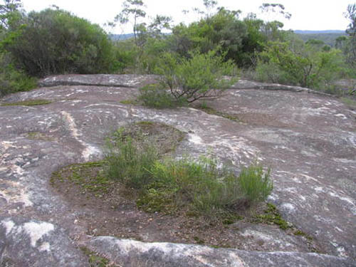
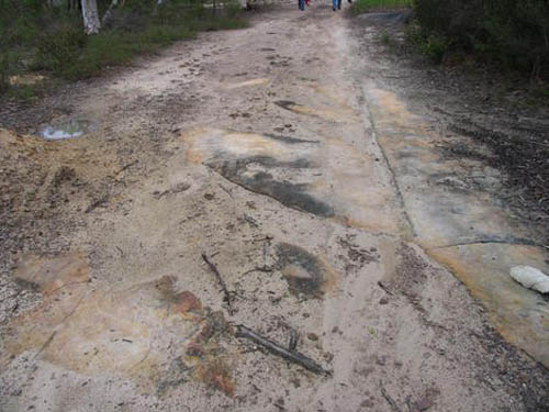
For the last two years I’ve been on a National Trust committee working on heritage listing for Coxs Road, the first road across the Blue Mountains west of Sydney that opened up Australia to European settlement. Its bicentenary is in 2015.
Numerous pieces of it survive intact, and it does, indeed, sometimes disappear under houses. I’ve also been working on an overlay of it for Google Earth and even some virtual sections done using SketchUp… Its entire construction is detailed in the diaries and reports of its builders so that it can still be tracked through farmland where there is no visible trace of it.
It also relates to Australian indigenous mapping via ancestor stories and songlines, to produce virtual highways that can easily be followed but have very little obvious physical evidence of their existence.
Geography is a dream. Like an absorbed twin, we are surrounded by forgotten roads. That there are lost routes even at the spatial core of the U.S. presidency is just one of many surprising acts of poetry that this world seems always capable of.
(Monticello story spotted via Jessica Saraceni’s great newsfeed over at Archaeology Magazine. Of interest, meanwhile, earlier on BLDGBLOG: Ancient Roads, from which part of this post actually comes, Ancient Lights, and Z).
A project I’ve been meaning to write about ever since seeing it in Vague Terrain #16 is “Pulse Room” by Rafael Lozano-Hemmer.
[Image: From “Pulse Room” by Rafael Lozano-Hemmer].
“Pulse Room,” originally produced back in 2006, was an “interactive installation featuring one to three hundred clear incandescent light bulbs,” the brightness of which was controlled by an interface and sensor that could detect “the heart rate of participants.”
When someone holds the interface, a computer detects his or her pulse and immediately sets off the closest bulb to flash at the exact rhythm of his or her heart. The moment the interface is released all the lights turn off briefly and the flashing sequence advances by one position down the queue, to the next bulb in the grid. Each time someone touches the interface a heart pattern is recorded and this is sent to the first bulb in the grid, pushing ahead all the existing recordings. At any given time the installation shows the recordings from the most recent participants.
The room thus becomes a counterpunctual archive of heart rates in space, throbbing like a chandelier in front of you.
[Image: From “Pulse Room” by Rafael Lozano-Hemmer].
Lozano-Hemmer later expanded this idea in scale quite significantly for his “Pulse Park” project, in which New York’s Madison Square Park was temporarily illuminated by a moving, heart-rate-controlled “matrix of light beams.”
But I would like to see something like “Pulse Subway,” say, where long tunnels flicker off around underground curves as heartbeat-like rhythms of light beat below ground, scaling the whole thing up yet further to form a piece of urban infrastructure (or is that simply a nightclub?); or even “Pulse Cinema,” in which the film itself fades in and flickers out according to the pulmonary ups and downs of the audience. Scenes of high-stress are seamlessly projected, but boring moments make the whole theater drain down toward black. One particularly caffeinated individual keeps the whole place bright as day.
[Image: From “Pulse Room” by Rafael Lozano-Hemmer].
It’s less the lighting effects that interest me here, though, than the idea of an archive of heart rates, a place where old rhythms could be stored. You could thus try out someone’s pulse—Usain Bolt’s record-shattering runs, or someone who’s survived a car accident—turning the facility (call it the CardiArchive) into a kind of Brainstorm for heart rates. Adventures in tachycardia. Heart-rate sharing.
Upload new pulses into the light-cloud and experience someone else’s panic as your own.
[Image: Photo by Kevin Sellers, courtesy of the Juneau Empire].
This weekend, April 16-17, over at The Lab (2948 16th Street) in San Francisco, sponsored by Swissnex San Francisco, an event called Activating the Medium will explore the sonic properties of ice—that is, “the physical, geographic, metaphoric, and mythological attributes of ice as manifested through sound.”
Specifically, you will hear “the sound of frozen lakes and ice caves,” as well as “various hydrophone recordings” taken in frozen circumstances around the world, and “a composition for real and imagined ice” will be played. As something like the main event of the evening, Cheryl E. Leonard’s work Antarctica will also be performed, samples from which can be heard on her blog Music from the Ice.
That being the case, I thought I’d post a by now very widely disseminated audio clip, recorded by Andreas Bick, of alien sounds racing through strained ice sheets on a lake in Berlin. The noises are incredible:
And this video, below, that Bick later linked to, offers a bit for anyone curious to hear more from these amazing phenomena that sound like laser warfare being conducted inside a glacier.
In any case, the event kicks off at 8:30pm both nights; tickets range from $8-$15. Enjoy!
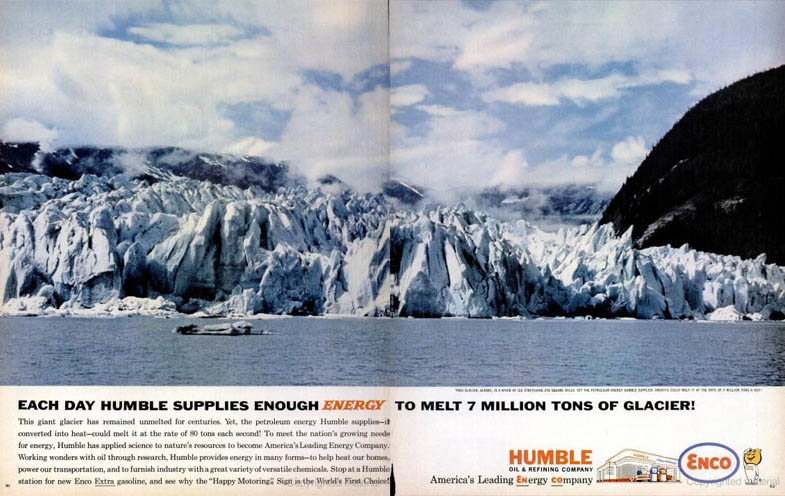 [Image: “Each Day Humble Supplies Enough Energy to Melt 7 Million Tons of Glacier!”].
 [Image: A giant battery grows in Texas; image courtesy of Popular Science].
 [Image: Engine house of an abandoned mine in Cornwall, photographed by Thenenan T. Kig, of tangential relationship to the Hydroplutonic Kernow tour].
  [Image: Strato Lab; photo via
  [Image: Strato Lab as sky-throne; photo via
  [Image: Strato Lab; photo via
  [Image: From an “ongoing speculative proposal
 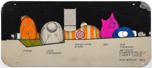 [Image: “Proposal for a
  [Image: “Speculative proposal showing use of the ‘Popular Pak’, a
  [Image: Proposal “
 [Image: A hike through the
  [Images:


 [Images: Spreads from
  [Images:
  [Image: Holland Tunnel exhaust tower, ventilating the Manhattanite underworld; photo via
  [Images:


 [Images: Four Moleskine spreads from


 [Images: From
  [Image: The walls of
 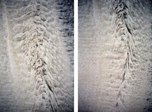 [Images: Extraordinary photographs of sand by
  [Image: A still from Inception, directed by Christopher Nolan, courtesy of
 [Images: A rotating hall and fight scene from Inception, courtesy of
  [Image: From Inception by Christopher Nolan, courtesy of
  [Image: Photo by Arni Saeberg/Bloomberg].
 [Image: Photo by AP Photo/Brynjar Gaudi].
 [Image: From Christopher Nolan’s film
  [Image: From Christopher Nolan’s film
  [Image: From

 [Images: From
  [Image: From
  [Image: From Christopher Nolan’s
  [Image: From
 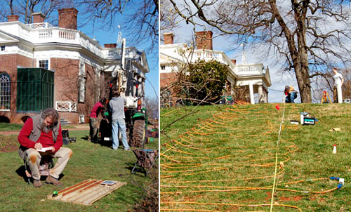 [Images: (left) An archaeologist examines soil cores. (right) Researchers plot lost roads across the grounds of Monticello. Courtesy of the
 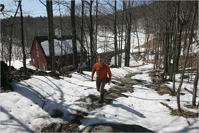 [Image: Walking an “ancient road” in Vermont; photo by
 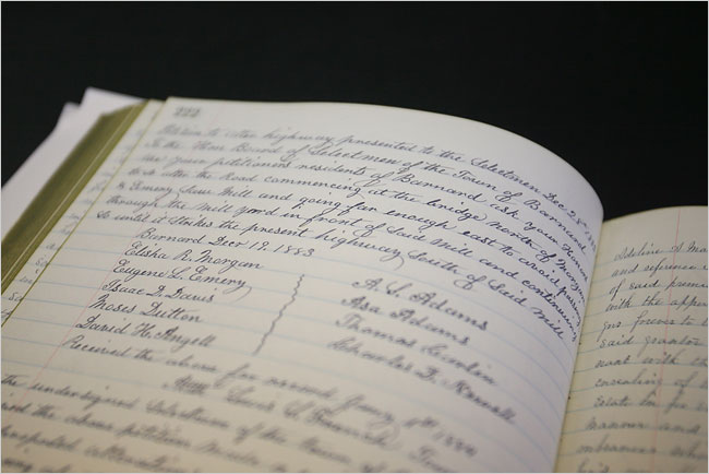 [Image: A hand-written inventory of Vermont’s ancient routes; photo by
 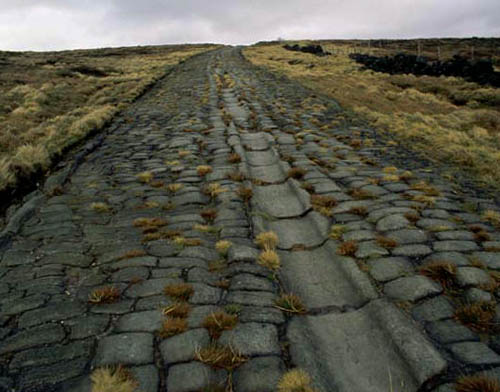 [Image: An old Roman road in Britain; photo via
 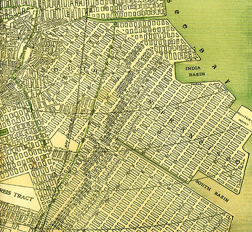 [Image: A map of San Francisco, including many “ghost streets,” courtesy of
 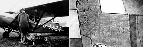 [Image: O.G.S. Crawford and his archaeological airplane; via Kitty Hauser’s
 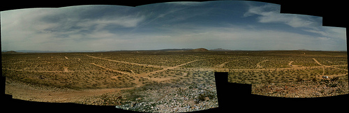 [Image: California City, CA; view
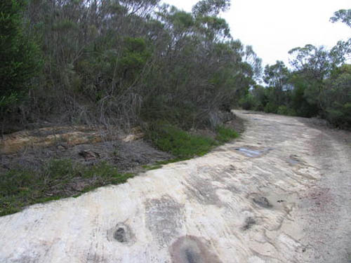
 [Image: Three views of Australia’s lost
 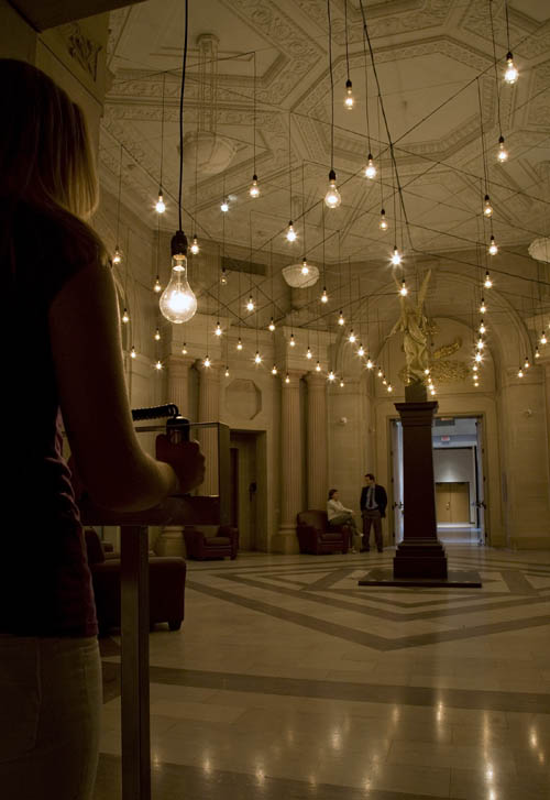 [Image: From “
 [Image: From “
 [Image: From “
 [Image: Photo by Kevin Sellers, courtesy of the