London Yields, Harvested

Note: This is a guest post by Nicola Twilley.

As Geoff mentioned last month, London’s Building Center hosted a daylong seminar at the end of May called London Yields: Getting Urban Agriculture off the Ground.
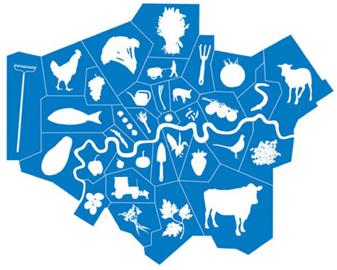
[Image: From London Yields: Urban Agriculture].

The speakers covered a lot of terrain—so, instead of a full recap of the event, the following list simply explores some of the broader ideas, responses, and questions about urban agriculture that stood out from the day’s presentations.

1. Becoming public policy
The event was introduced and moderated by David Barrie, a sustainable development consultant, who framed the day as a collective opportunity to brainstorm ways in which urban agriculture could be moved from mere “sustainable accessory” to become a standard practice of both everyday life and city design. Interestingly, Mark Brearley, Head of Design at Design for London (DfL) and the day’s first speaker, provided confirmation of Barrie’s diagnosis, confessing that food production was a recent add-on to many of their open space projects. Why? “Because people were asking us about it,” he said.

Brearley’s presentation was an overview of DfL’s hundreds of urban regeneration and infrastructure improvement projects; these are, in themselves, interesting but, in aggregate, somewhat exhausting. However, as an office of the London Development Agency, working on behalf of the Mayor of London, Brearley was able to provide a fascinating insight into some of the current institutional priorities that need to be satisfied before urban agriculture can become a standard part of London public policy. For example, DfL’s main interest in food production today is in terms of its “public engagement potential” and their primary stumbling block is how to measure the scaleability of local initiatives. Any London-based urban agriculture projects hoping for a mayoral blessing, take note!

2. Food is a design tool
The second speaker was Carolyn Steel, author of the excellent book Hungry City: How Food Shapes Our Lives. Hungry City traces how food has shaped both the city and its productive hinterland throughout history, from the Sumerian city of Ur to today’s London via the markets and gates of ancient Rome. Steel provides a wide-ranging historical look of food production, importation, regulation, and culture, before putting forward her own intriguing and potentially revolutionary proposition: what would happen if we consciously used food as a design tool to create a “sitopic” city? Steel’s coinage here, sitopia—from “sitos” (food) and “topos” (place)—is derived from her realization that “food shares with utopia the quality of being cross-disciplinary… capable of transforming not just landscapes, but political structures, public spaces, social relationships, [and] cities.” And because “food is necessary,” a sitopian city (unlike its utopian cousin) would remain tied to reality and of universal relevance.

The quotations above come from Steel’s book, however, rather than her lecture; twenty-five minutes was enough time to provide fascinating examples of food’s role in shaping cities and urban life, but, sadly, not enough to explain (let alone explore) further thoughts about food’s use as an urban planning tool. More to come soon, I hope, on this topic…

[Image: Ebenezer Howard’s original scheme for the Garden Cities of To-morrow shows a landscape reimagined in terms of food production and supply. As Carolyn Steel explains in her own book Hungry City, Howard’s plans relied on land reform that was never carried out, and the garden cities of today (Letchworth, Welwyn, etc.) are, as a result, little more than green dormitory suburbs].

3. Partnerships as infrastructure
Anna Terzi, who runs London Food Link’s small grants scheme for Sustain, was the day’s third speaker; she described one of their current projects, demonstrating how key insights from both Mark Brearley’s and Carolyn Steel’s talks might look in action.

Sustain (a nonprofit alliance for better food and farming) is currently poised to create borough-wide institutional change by partnering with Camden Council and Camden Primary Care Trust (part of the National Health Service). This alliance—with its intriguing implication that the National Health Service might be the one institution with the most to gain by promoting urban agriculture—speaks to the impact of creating new interest groups for locally grown food. By partnering with institutions responsible for dealing with established urban challenges—issues such as public health, economic growth, community engagement, waste, and environmental sustainability—groups like Sustain have the potential to take urban agriculture from decorative hobby to investment-worthy infrastructure.

The Camden partnership’s report (still in draft stage) aims to outline a relatively coherent and holistic food program for the borough—a plan that promises to use food to reshape at least this part of the city, in terms of promoting social enterprise, meeting infrastructure needs, and reducing health inequalities.

[Image: A lemon grown in Dulwich; photograph by Jonathan Gales (2008), ©Bohn & Viljoen Architects].

4. Mapping and visualization tools
The last two presentations of the day agreed that successfully producing food in the city requires a detailed resource inventory combined with effective promotion efforts. Mikey Tomkins, a PhD candidate at the University of Brighton, described systematically mapping the rooftops, grass patches, vertical faces, and vacant lots of Elephant & Castle—whereupon he discovered that 30% of the area’s food needs could be met through the cultivation of found space alone.

Architects Katrin Bohn and Andre Viljoen, creators of the uninspiringly named CPUL (Continuous Productive Urban Landscapes), emphasized the need to think about spare inventory in terms of population and three dimensionality (their Urban Agriculture Curtain filled a display window one floor above us). Their research techniques included the accumulation of census data and questionnaires combined with GPS mapping and site visits in order to analyze a landscape’s food production capacity.

Both Tomkins and Bohn & Viljoen also showed several projects intended to help people read the city in terms of food, using tools as diverse as “edible maps” of London and visual analyses of urban agriculture in Havana, to installations and public events, such as the Continuous Picnic. This was a day-long event, part of the 2008 London Festival of Architecture, that included an “Inverted Market” (bring your own locally grown fruit and vegetables to be admired, judged, and then prepared), as well lessons in “Community Composting”; a giant public picnic then spread throughout Russell Square and Montague Place, with connecting corridors between.

Meanwhile, for his Edible Maps series, an example of which appears below, Tomkins targets a new type of urban resident: the “food-flâneur,” who, map in hand, “could start to picture… the grassed areas around housing, the corners of parks, or the many flat rooftops of this quarter of Croydon spring into life with psychogeographic food.”

Another example of urban agriculture as an opportunity for community activation was Croydon Roof Divercity, Tomkins’s collaboration with AOC (previously discussed, along with other AOC projects, on BLDGBLOG here).

[Image: From Mikey Tomkins’s series of Edible Maps, this guide represents the area around Surrey Street car park, site of Croydon Roof Divercity, in terms of inventory and potential yield].

5. Easy, cheap, and somewhat under control
Both Anna Terzi and Bohn & Viljoen recognized the difficulty of maintaining urban agriculture projects, once the initial novelty has worn off. Bohn & Viljoen are currently working on a twelve-step program to prevent relapse, while Sustain are offering ongoing practical and financial support to new food growing spaces in London through their Capital Growth initiative.

Throughout the morning, David Barrie repeatedly registered his concern that urban agriculture needed to be economically viable, not just an upscale $64 Tomato lifestyle choice. Several of the presenters added a layer of nuance to Barrie’s formulation, noting that cheap food has simply had its costs externalized and hidden (Carolyn Steel) and that organizations like the New Economics Foundation are developing the much-needed tools to measure urban-agriculture-created value, such as increased community engagement and environmental sustainability, which is currently perceived as intangible and qualitative (Katrin Bohn). Mikey Tomkins argued against an economics-based one-size-fits-all approach to urban agriculture, explaining that the scale of a food growing project determines its possible benefits. Thus differentiated, food gardening generates educational and quality of life outcomes and should be measured accordingly, while market gardening creates recycling benefits, and urban agriculture can be evaluated in terms of yield.

Finally, the elephant in the room was the degree of coordination and regulation needed to transform London into a food-producing landscape. In an environment where, as Carolyn Steel said, the supermarkets where Londoners buy more than 80% of their groceries refused to participate in consultations with the Mayor’s London Food Strategy, it seems unlikely that sustainable food production and distribution will become the norm without legislative intervention.

In her book, Steel quotes Cassiodorus, a Roman statesman who wrote: “You who control the transportation of food supplies are in charge, so to speak, of the city’s lifeline, of its very throat.” At the moment, Steel tells us, roughly 30 agrifood conglomerates—unelected, and with no responsibility other than to their shareholders—have almost unfettered control over London’s food supply. Until that changes, urban agriculture can’t help but remain “at the artwork stage”—an inspiring, attractive, and completely optional extra.

[Other guest posts by Nicola Twilley include Watershed Down, The Water Menu, Atmospheric Intoxication, Park Stories, and Zones of Exclusion].
London Future Green

Note: This is a guest post by Nicola Twilley.

During a brief Tube journey earlier today, this image stood out against a backdrop of mobile phone advertisements, travel insurance offers, and posters for English-language schools.

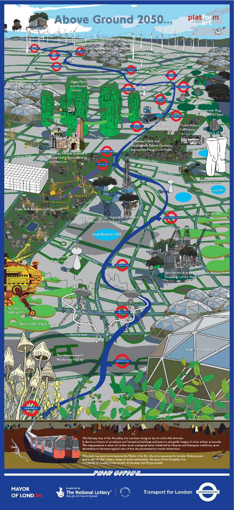
[Image: “Above Ground” by Nils Norman, commissioned by Platform for Art for Transport for London; view it as a 2.6MB PDF].

Designed by artist and architect Nils Norman, this fantasy map traces the Piccadilly line’s route through an alternate London whose landmarks consist of utopian eco-fantasies (mushroom farms and geothermal energy platforms) alongside various post-war avant-garde architects’ unrealized projects for the city.

Mike Webb’s Sin Centre and Cedric Price’s Fun Palace sit next to the Westminster Bog and Wetland Chain, while Thomas Affleck Greeves’ Monument to Commemorate the Passing of the Good Old Days of Architecture nestles in the shadow of a dual purpose algae factory and housing tower not far from George Orwell’s Ministries of Love, Peace and Plenty. The result is an interesting juxtaposition of hypothetical projects designed as critique or provocation, and equally imaginary proposals rooted in a utopian impulse toward sustainability: Superstudio’s Continuous Monument is set alongside the North London Turbine Fields and the South Kensington Vegetable Oil Refinery.

It turns out that the map dates from summer 2007, and was part of a year-long celebration of the Piccadilly line’s centenary. Transport for London commissioned multiple public art projects to mark the occasion, under the curatorial title “Thin Cities”—a reference to Italo Calvino’s invisible city of Armilla, in which a “forest of pipes… rise[s] vertically where the houses should be and spread[s] out horizontally where the floors should be.” This striking description highlights the Tube’s structural centrality to London—even if Calvino’s “underground veins” carry water, not commuters or tourists.

Other projects from the series include the first ever whole-Tube wrap, as well as the calls of fifty-two different migratory species (one per week) broadcast every twenty minutes over the Knightsbridge station tannoy. Taken from the British Library’s sound archive, these included the clicks of a bottle-nosed dolphin and the honks of a Whooper swan—and they were each introduced by the official voice of the Tube, Emma Clarke.

All the Thin Cities projects are now archived online; they’re presented alongside photos and anecdotes from each station on the Piccadilly line, such as the best place to watch planes take off and land at Heathrow (hint: it’s a small footbridge outside Hatton Cross) and the fate of Alfie the cat (he was adopted by a Station Supervisor after 10 years’ independent living at Cockfosters).

[Check out Archinect‘s interview with Nils Norman for more. Also vaguely related: Just Add Water. Previous posts by Nicola Twilley include Atmospheric Intoxication, Park Stories, and Zones of Exclusion].

Atmospheric Intoxication

[Image: Photo by Jonathan Brown. Brown reviewed the launch on his blog, Around Britain with a Paunch, writing that he and his friends “mingled in the mist, like shadows on the set of Hamlet”].

Note: This is a guest post by Nicola Twilley.

A former boutique storefront in London has become the temporary home for a pop-up bar with a twist: 2 Ganton Street is currently the U.K.’s “first walk in cocktail.” Created by Bompas & Parr (known for their earlier experiments with glow-in-the-dark jello and scratch & sniff cinema), the “Alcoholic Architecture” bar features giant limes, over-sized straws, and most importantly, a gin-and-tonic mist.

Lucky ticket-holders (the event has now sold out) are equipped with plastic jumpsuits and encouraged to “breathe responsibly” before stepping into an alcoholic fog for up to 40 minutes – long enough to inhale “a fairly strong drink,” according to Wired UK.

The Guardian noted that “as far as taste goes, this is the real deal,” with some mouthfuls of air “sweeter with tonic and others nicely gin-heavy.” Sam Bompas explained to Wired that they chose to vaporize gin and tonic (rather than, say, an appletini) because of its “nice smell, botanical flavours and freshness.” St. John Ambulance volunteers are on hand, though the only reported casualties so far seem to have been hairstyles – victims of “gin-frizz”. The Guardian concluded that, “With no sentient ice cubes able to confirm it, one can only assume that this is what the inside of a G and T feels like.”

[Image: Antony Gormley’s Blind Light, 2007, courtesy of the artist and Jay Jopling/White Cube, London, ©Stephen White].

The project was inspired by Antony Gormley’s Blind Light, a fog box installed at the Hayward Gallery in 2007. Bompas & Parr, who describe their world as operating in “the space between food and architecture,” worked with the same company, JS Humidifiers, to adapt and install the ultrasonic humidifiers that create the thick, gin-based fog.

Though even typing “thick, gin-based fog” makes me feel a bit queasy, the experiment does seem to provide a perfect instantiation of London’s social history, the city’s prevailing damp, and its dense population. If the project is recreated elsewhere, perhaps local conditions will shape the installation: a freezing hail of neat vodka will form a layer of crystals on fur hoods and boots at a cavernous underground bar in Moscow; or a refreshing rum-and-coke mist will cool sunburned spring-breakers in the overcrowded hotel rooms of Daytona Beach.

[Image: JS Humidifiers].

Of course, the architectural manipulation of humidity is not limited to alcohol. As JS’s website boasts: “For precise control of humidity and temperature, extreme outputs, specialist construction for controlled environments or unusual control, whatever the requirement JS will design and manufacture a solution.” Existing clients for these bespoke humidification systems apparently include medical device manufacturing, offshore oil exploration, firearms production, specialist printing, pharmaceutical production and automotive manufacturing. It seems clear that custom atmosphere solutions are a product with endless applications: migrating from industry to art to retail, with the next step being high-end custom interior design for the very rich.

It can only be a matter of time before wealthy individuals are able to wake up to vaporized coffee, maintaining their multi-tasking edge by inhaling caffeine for that last half-hour of sleep, while the riders of Hollywood stars will routinely specify custom dressing rooms bathed in a fine mist of light-diffusing, age-defying elixirs.

[Other guest posts by Nicola Twilley include The Water Menu, Dark Sky Park, Park Stories, and Zones of Exclusion].

Zones of Exclusion

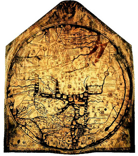
[Image: The charismatic boundaries of an earlier worldview – here, the Hereford Mappa Mundi].
Note: This is a guest post by Nicola Twilley.

Another question for the topic of whether or not a “dense assortment of buildings” can ever be a real city: What is London for an eighteen-year old whose entire urban experience is confined to 200-square meters and who has never seen the Thames?

Researchers at the University of Glasgow, sponsored by the Joseph Rowntree Foundation, have spent the past two years asking young residents of Bradford, Peterborough, London, Glasgow, Sunderland, and Bristol to draw maps of their own individual urban experience in order to explore micro-territoriality as both a cause and a symptom of social exclusion. You can read the full PDF of their report here.

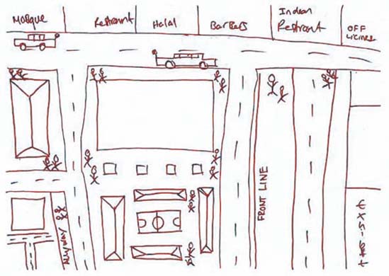
“In Glasgow, Sunderland and Bradford,” they found, “a recognizable territory might be as small as a 200-meter block or segment.” In Tower Hamlets, London, fifteen and sixteen-year old boys mapped their world into three streets, a football pitch, a barber shop, mosque, Indian restaurant, and – just beyond the clearly marked “Front Line” – an off-license, or liquor store.

[Image: From the Joseph Rowntree Foundation report, “Young people and territoriality in British cities” (download the PDF)].

Some of the sketches even remind me of medieval maps: the known world is an island of familiarity, simultaneously shown much larger than scale but made tiny and precious by the monsters of “Terra Incognita” that surround it. In the case of a 15-year-old girl from Bradford, today’s dragons are “moshers,” “chavs,” “Asians,” and “posh people” – all “Enemys.” The researchers found that teenage boys display an even more complete ignorance of the world beyond their perceived boundaries: these two maps of the same area in Glasgow were drawn by young men in the same class at the same school, who live on different sides of the same road.

[Images: From the Joseph Rowntree Foundation report, “Young people and territoriality in British cities” (download the PDF)].

The report’s authors examined the causes, nature, and impact of micro-territorialization. Their research uncovered Bristol’s “postcode wars,” where gangs spray-paint their postcode in rival areas as a form of aggression, as well as descriptions of the maneuvers involved in going to school in one part of Bradford that match the Schlieffen Plan in strategic complexity. “In some places,” they note with reference to Glasgow and Sunderland, “territoriality was a leisure activity, a form of ‘recreational violence.’” In other words, bored and economically deprived teenagers are transforming 1960s council estates and Victorian terraces into a real-world, multiplayer World of Warcraft.

Of course, excessive loyalty to the local, and the resulting lack of mobility, has a significant and negative impact on access to education, services, and job opportunities. In the words of one interviewee from Glasgow:

If your horizons are limited to three streets, what is the point of you working really hard at school? What is the point of passing subjects that will allow you to go to college or university if you cannot travel beyond these streets? What’s the point of dreaming about being an artist, a doctor, etc., if you cannot get on a bus to get out of the area in which you live?

The report points out an interesting irony here: current policies in urban regeneration are dominated by strategies to increase “place attachment” as a means “to reinforce social networks and maintain the quality of an area through pride.” However, the areas that actually generate such loyalties are, in the authors’ words “often ones that have little that conventionally invokes pride.”

It was difficult to say which was more depressing – the relentless defense of a featureless piece of open space on the fringes of a Glasgow housing scheme where there is nothing whatsoever by way of amenities, or the confinement to a socially isolated but densely populated and built-up quarter-square-mile of London of young men for whom the culture and wealth of one of the world’s great cities might as well be on another continent.

The report goes on to identify 244 anti-territorial projects (ATPs) currently in progress across the UK. Most use sports or other “hook” activities to encourage association and to teach networking skills. Disappointingly, none tackle the issue in terms of the design of physical space.

So what does the anti-territorial city look like? Some things to consider: unsurprisingly, the report found that most conflicts “occurred on boundaries between residential areas, which were typically defined by roads, railways, vacant land or other physical features.” The city center also becomes a venue for bigger showdowns: a youth worker in Peterborough explains that “the flashpoints are in the city center, the ‘big stage,’ the one place they all, you know, congregate on a Saturday.” Finally, the researchers found that micro-territorialization took place across the spectrum of low-income housing stock, from “high-density, flatted, inner-city estates; traditional, pre-1914 areas of terraced housing; and suburban, often council-built environments.”

As the authors rightly point out, lack of jobs and economic hardship are key structural forces contributing to “problematic territoriality.” But what role does urban planning, landscape design and the built environment have to play?

Can the design of the city itself generate – or mitigate against – territoriality?

(Note: Read the Guardian‘s take on the Joseph Rowntree Foundation report here and here).

15 Lombard Street

[Image: The cover and a spread from 15 Lombard St. by Janice Kerbel].

15 Lombard St. is a book by artist Janice Kerbel, published back in 2000. It presents itself as “a rigorously researched masterplan of how to rob a particular bank in the City of London.”

By observing the daily routine in and around the bank, Kerbel reveals the most detailed security measures such as: the exact route and time of money transportation; the location of CCTV cameras in and around the bank along with precise floor plans that mark the building’s blind spots.
Kerbel’s meticulous plans include every possible detail required to commit the perfect crime.

The book was pointed out to me by Sans façon in relation to an earlier post here on BLDGBLOG about the city re-seen as a labyrinth of possible robberies and heists that have yet to be committed – a geography of tunnels yet to be dug and vaults yet to be emptied.

But is there a literary genre of the crime plan? An attack or robbery outlined in its every detail. Is this fiction, or some new form of illicit literature, detailing speculative and unrealized crimes hidden in the city around us? Is robbing a building just another type of architectural analysis? Or does one put such a thing into the category of counter-geography – a minor cartography, a rogue map? Or perhaps radical cartography, as the saying now goes? Would there be an impulse toward censorship here?

There’s a fascinating series of interviews waiting to be done here with people who work in building security – how a building is deliberately built to anticipate later actions. Or, should we say: how a building is built to contain the impulse toward certain, more radical uses.

When the burglars get to this door, they’ll become frustrated and will try to break through the nearby window, instead – so we must reinforce this window and put a camera nearby.

The building has within it certain very specific possible crimes, the way this house contained a “puzzle.” I’m reminded of the famous Bernard Tschumi line, and I’m paraphrasing: Sometimes to fully appreciate a work of architecture you have to commit a crime.

Architectural space becomes something like an anticipatory narrative – the exact size and shape of a future heist, nullified. It outlines future crimes the way a highway outlines routes.

(Thanks again to Sans façon for the tip!)

Divided Kingdom

[Image: Circle Line Pinhole 32, from Rob Gardiner’s inspired photographic project, Walking the Circle Line, London].

Rupert Thomson’s recent novel Divided Kingdom is set in a world where the whole of Britain has been broken up into four sectors, the population itself forcibly “rearranged” according to emotional temperment.

Well-disciplined over-achievers are sent to one quarter; despair-wracked introspectionists another; pick-up truck driving nutters prone to violence take a third (I came I saw I lost my temper, its postcards read); and some other group I’m overlooking at the moment gets the last bit.

Walls and fences begin to appear; soon people complain of “border sickness” as they are further hemmed in by a series of Internal Security Acts. “Throughout the divided kingdom,” we read, “the walls of concrete blocks had been reinforced with watch-towers, axial crosses and even, in some areas, with mine-fields, which rendered contact between the citizens of different countries a physical impossibility.”

London itself is “divided so as to create four new capitals,” and each major bridge over the Thames is “fortified, along with watch-towers at either end and a steel dragnet underneath.” However, “in stretches where the river itself had become the border all the bridges had been destroyed. The roads that had once led to them stopped at the water’s edge, and stopped abruptly. They seemed to stare into space, no longer knowing what they were doing there or why they had come.”

[Image: From Under Blackfriars Bridge, London, by Rob Gardiner].

There is even a “tourist settlement called the Border Experience” constructed near one of the crossings – apparently learning from Venturi, complete “with theme hotels, fast-food restaurants and souvenir shops.”

In one sector, all the motorways “had been converted into venues for music festivals or sporting events, and others had been fortified, then turned into borders, their tall grey lights illuminating dogs and guards instead of traffic, but for the most part they had simply been allowed to decay, their signs leaning at strange angles, their service stations inhabited by mice and birds, their bridges choked with weeds and brambles or, as in this case, collapsing altogether. In time, motorways would become so overgrown that they would only be visible from the air, half-hidden monuments to an earlier civilization, like pyramids buried in a jungle.”

[Image: Circle Line Pinhole 16, from Rob Gardiner’s Walking the Circle Line, London].

While still a young boy, the narrator develops “border games” with a mate; they “prowl among the cement-mixers and scaffolding poles” next to “a section of the motorway that was in the process of being dug up,” and they use cardboard tubes to spy on guards stationed several acres away.

In any case, parts of Divided Kingdom read like descriptions of Dubai – or what Mike Davis refers to as Dubai’s “monstrous caricature of futurism,” as that city strives “to conquer the architectural record-books.”

There is something called the Underground Ocean, for instance. Thomson’s narrator and his entourage are led down into a basement warehouse, where they stand beside a lifeguard on a boardwalk in the dark:

The lifeguard’s voice floated dreamily above us. Any second now, he said, the scene would be illuminated, but first he wanted us to try and picture what it was that we were about to see. I peered out into the dark, my eyes gradually adjusting. A pale strip curved away to my right – the beach, I thought – and at the edge furthest from me I could just make out a shimmer, the faintest of oscillations. Could that be where the water met the sand? Beyond that, the blackness resisted me, no matter how carefully I looked.
“Lights,” the lifeguard said.
I wasn’t the only delegate to let out a gasp. My first impression was that night had turned to day – but instantly, as if hours had passed in a split-second. At the same time, the space in which I had been standing had expanded to such a degree that I no longer appeared to be indoors. I felt unstead,y, slightly sick. Eyes narrowed against the glare, I saw a perfect blue sky arching overhead. Before me stretched an ocean, just as blue. It was calm the way lakes are sometimes calm, not a single crease or wrinkle. Creamy puffs of cloud hung suspended in the distance. Despite the existence of a horizon, I couldn’t seem to establish a sense of perspective. After a while my eyes simply refused to engage with the view, and I had to look away.
“Now for the waves,” the lifeguard said.

It is interesting to note that, at the end of the book, in the Acknowledgements, Thomson cites S,M,L,XL by Rem Koolhaas as having been a literary resource.

[Image: Circle Line Pinhole 52, from Rob Gardiner’s Walking the Circle Line, London].

While it seems rather obvious that the book is not meant to present the next likely development in national governance or urban planning, many readers – i.e. Amazon reviewers – seem upset by the premise, and repeatedly point out that this “could never happen.” But surely that’s not the point? As with all of Thomson’s novels the writing is exquisite, at times dreamlike yet descriptively precise; the book is also one of the few examples I can think of where I actually wished the book had been substantially longer (it’s 336 pages).

If you do read it, let me know what you think.

[Image: Circle Line Pinhole 64, from Rob Gardiner’s Walking the Circle Line, London].

(Thanks to Steve & Valerie Twilley for the book! Meanwhile, for more of Rob Gardiner’s photographs, see Gardiner’s blog; I’m a particular fan of his London work).

A Sketch for London

For an exhibit during last month’s London Architecture Biennale 2006, curator Matteo Cainer invited “architectural studios from outside the UK (…) to sketch a visionary project for London.” Graphic speculation about another London yet to come, Cainer hoped, would “further consolidate architecture’s role in imagining a future for the city”:

Architects have been invited to take an outsider’s view, and as such submit a sketch for an imaginative project in the city of London. They are free to choose a site and focus, whether addressing issues of planning, landscape, infrastructure or building. The central challenge remains what it has been for centuries: to make architecture a vessel for new and controversial ideas. Gathering together architects with sketches, and critics with words, will entice visitors into a theatre of architectural imagination where a wide range of daring projects, conceived by some of the most inventive and newly emerging architects, come together in a panorama of architecture’s current potential and promise. This will in turn create a platform for discussion and a critical examination of today’s approach to architecture.

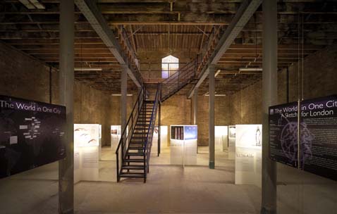
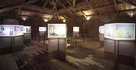
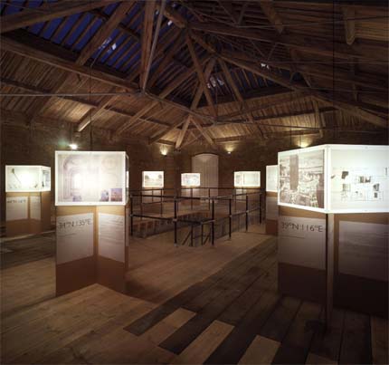
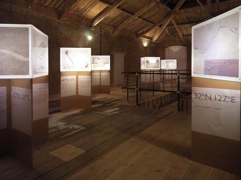
The result was The World in One City – A Sketch for London, an exhibit beautifully designed by Cainer’s own Design Research Studio at Fletcher Priest Architects.

[Images: ©Chris Gascoigne].

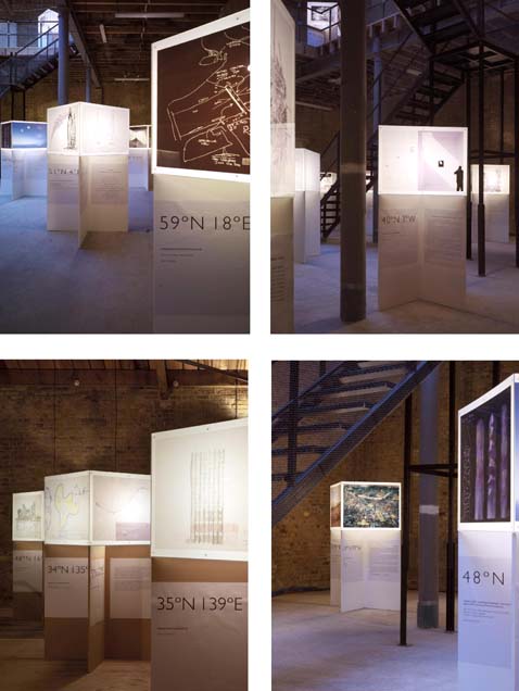
After emailing Cainer expressing interest in the exhibit itself and in the architectural projects it featured, he responded with a PDF from which these images were taken. Here we see interior shots, offering a glimpse of the show’s dominant theme: coordinate points of latitude and longitude, geographic sites of architectural speculation.

[Images: ©Chris Gascoigne].

“The show tries to move beyond the current scene, dominated by cyberspace and video simulation,” Cainer explains, “and beyond the familiar client restraints and the fashion parade of magazines.” Instead, the exhibit’s purpose is to focus on “the ‘sketch’ as the fulcrum of architectural imagination. Concepts and subsequent sketches are often underestimated: sketching is not only practical but also essential; it is the quickest, most accessible way for generating ideas.”

A website for the show is in the works, as well as a publication.
Finally, let me just add that the idea for this exhibition is totally fantastic, and that every city in the world, frankly, should perform this kind of imaginative self-reflection at least once every few years. By openly speculating about conjectural urban futures – whether those include pedestrian malls, blimp-aquariums, or even insanely ambitious green roof projects – residents of cities everywhere can be reminded that their own urban environment is an ongoing project, and that everyday life itself can be upgraded, reprogrammed, better designed. After all, the architectural future is just a few words and sketches away.

Bride of Climate Change

[Image: The earth is coming to get you… A dust storm in Iraq, via Pruned].

“Someday the U.S. military could drive a trailer to a spot just beyond insurgent fighting and, within minutes,” we read, “reconfigure part of the atmosphere, blocking an enemy’s ability to receive satellite signals, even as U.S. troops are able to see into the area with radar.”

They’ll roll up, in other words – and throw storms at you.

[Images: The Grand Island Supercell, photographed by Mike Hollingshead].

But imagine what an architect, or landscape architect, might do with such a thing: some atmosphere-reconfiguration technology disguised inside pillars, towers and arcades. An 18th c. English garden maze, lined with lichen-covered statuary, and each standing figure is an atmosphere-machine, generating clouds or clearing them. A cure for British weather.

You can turn them all on, in the right order, fast enough, and form tornadoes. The murderer of birds, whirled to their doom. And if it’s too close to Heathrow, your garden becomes a national security threat.

Harry Potter and the Garden of Storms.

[Images: An almost theologically intense supercell, photographed by Mike Hollingshead].

A new tower is built in midtown Manhattan, attracting storms, its upper floors constantly awash in sleeves of cloud cover. Ghostbusters III. Transmitters hidden inside marshland graveyards far east of London: Dracula Returns.

Or none of the above, just a military unit on a border somewhere, staring through binoculars, preparing to hurl hurricanes, the grand wizardy of war: Bride of Climate Change. A weaponized earth.

Roof-farming southeast London


Swiss Cheese City, by London-based architecture firm Agents of Change (AOC), proposes that “vacancy in cities” is really “a starting point for a new urban form.” Accordingly, the project hopes to “generate new possibilities from holes in the built fabric,” such as “Special Cultivation Zones (SCZs).”
Special Cultivation Zones are an urban land-bank, defined by “temporary boundaries within which land can’t be bought or sold, and emerging skills, social networks and locally-grown produce are cultivated in the ‘vacant’ city fabric.”
(For more on urban farming, see Pruned or Inhabitat).
Then there’s AOC’s Croydon Roof Divercity project –


– which radically rethinks the landscape of Croydon’s roofs (and sounds really, really fun): “Taking the flat roofs of Croydon as our testbed,” they write, “we propose a new roofscape for the city – beaches, ice rinks, golf courses, allotments, skateboard parks and pasture refresh Croydon’s tired concrete.” How about a shooting range? (For more on green roofs, see Inhabitat).
After all, AOC asks, how could London be adapted “to an agricultural logic – the logic of rotation, seasons, ground and growth?”
Thus, with a vision straight out of sci-fi, they describe Hackney New Garden City, complete with an “Agricultural Action Zone (AAZ).” This would include “a self-sufficient ecology of grass roads, localised rainwater collection, organic solar films and biological compost systems… liberating the ground’s agricultural potential.”


[Images: Hackney New Garden City, before and after].

For another place you could put those ideas to work, see Philadelphia’s Urban Voids; then check out these photos of “arbortecture” – or, plants growing out of buildings. (Via Pruned).

Silt

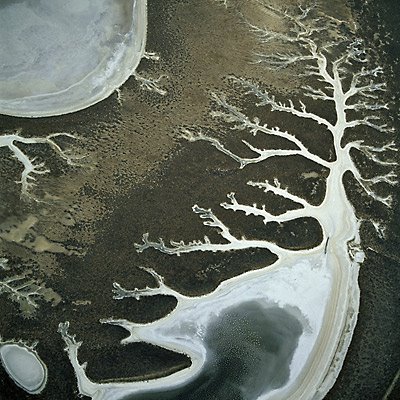
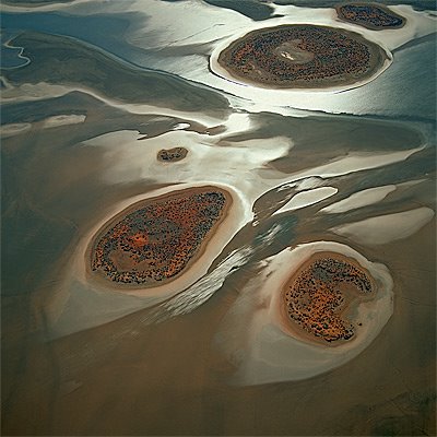
The surface of the planet renews itself through geothermal hydrology, sulfuric lakes, new continents of silt –


– as natural acids scour shapes in slow terrains.

These are all photographs by Bernhard Edmaier, whose work can be found on his own website


– and in the beautiful (if unfortunately named) Earthsong.

Meanwhile – though I repeat myself – these bring to mind J.G. Ballard’s novel The Drowned World, with its vision of a flooded, neo-tropical Europe, London become a backed-up toilet full of silt and Jurassic vegetation, “a nightmare world of competing organic forms returning rapidly to their Paleozoic past.”

Huge iguanas laze around in the heat. Buildings left and right are collapsing, their lower six floors immersed in polluted seawater, “miasmic vegetation… crowding from rooftop to rooftop.”

The city is fossilizing.

As Ballard writes: “A few fortified cities defied the rising water-levels and the encroaching jungles, building elaborate sea-walls around their perimeters, but one by one these were breached. Only within the former Arctic and Antarctic Circles was life tolerable.”

So the story goes that a research biologist is touring this neo-tropical London, boating from hotel to hotel across fetid lagoons, recording the types of plants that infest the city. Meanwhile monsoons are coming up from the south, everyone is dying of skin cancer and no one can sleep. The intensity of the sun’s radiation is making everything mutate.

In between some eyebrow-raising moments of ridiculous, pop-Nietzschean pseudo-philosophy – the surviving humans find themselves psychologically regressing down the totem pole of evolution toward… something or other; it’s all very psychedelic and 2001 – there are some cool descriptions of these new urban tropics:

“Giant groves of gymnosperms stretched in dense clumps along the rooftops of the submerged buildings, smothering the white rectangular outlines… Narrow creeks, the canopies overhead turning them into green-lit tunnels, wound away from the larger lagoons, eventually joining the six hundred-yard-wide channels which broadened outwards toward the former suburbs of the city. Everywhere the silt encroached, shoring itself in huge banks against a railway viaduct or crescent of offices, oozing through a submerged arcade… Many of the smaller lakes were now filled in by the silt, yellow discs of fungus-covered sludge from which a profuse tangle of competing plant forms emerged, walled gardens in an insane Eden.”

In any case, one could easily imagine Bernhard Edmaier’s photographs here bearing much in common with Ballard’s new alluvial world of fresh earth, architecture reduced to deltas of sand. Old eroded reefs of brickwork. Lagoons of pollution.


Erosion and hydrology, the most powerful urban forces on earth.

tropical.bldg

“Tropical Green” runs 9-10 February 2006, down in sunny Miami: “The two-day Tropical Green conference will be an invaluable experience for architects, interior designers, developers, city planners, politicians, and voters in search of learning the ways of 21st century design that will both help the environment and their wallets.” Check it out.

It’s funny, meanwhile, but I’m reading The Drowned World by J.G. Ballard, even as I post this, and his descriptions – written in 1962 – of a flooded, neo-tropical London have totally changed my conception of what “a tropical city” actually is.

In Ballard’s novel the sun has developed a kind of astrophysical Tourette’s Syndrome, and it’s started scorching the planet with radiation storms and UV bursts. This has melted the icecaps, raised the ambient global temperature to 120º+ and forced everyone to move to northern Canada and Siberia.

London has become a kind of backed-up toilet of silt and Jurassic vegetation, “a nightmare world of competing organic forms returning rapidly to their Paleozoic past.” Huge iguanas lumber around in the heat. Buildings left and right are collapsing, their lower six floors immersed in polluted seawater, “miasmic vegetation… crowding from rooftop to rooftop.”

The city is fossilizing.

As Ballard writes: “A few fortified cities defied the rising water-levels and the encroaching jungles, building elaborate sea-walls around their perimeters, but one by one these were breached. Only within the former Arctic and Antarctic Circles was life tolerable.”

[Image: The Drowned World‘s rather unimpressive cover…].

So the story goes that a research biologist is touring this neo-tropical London, boating from hotel to hotel across fetid lagoons, recording the types of plants that infest the city. Meanwhile monsoons are coming up from the south, everyone is dying of skin cancer and no one can sleep. The intensity of the sun’s radiation is making everything mutate.

In between some eyebrow-raising moments of bad pop-Nietzschean pseudo-philosophy – the surviving humans find themselves psychologically regressing down the totem pole of evolution toward… something or other; it’s all very psychedelic and 2001 – there are some cool descriptions of these new urban tropics:

“Giant groves of gymnosperms stretched in dense clumps along the rooftops of the submerged buildings, smothering the white rectangular outlines… Narrow creeks, the canopies overhead turning them into green-lit tunnels, wound away from the larger lagoons, eventually joining the six hundred-yard-wide channels which broadened outwards toward the former suburbs of the city. Everywhere the silt encroached, shoring itself in huge banks against a railway viaduct or crescent of offices, oozing through a submerged arcade… Many of the smaller lakes were now filled in by the silt, yellow discs of fungus-covered sludge from which a profuse tangle of competing plant forms emerged, walled gardens in an insane Eden.

Anyway, one could analyze the metaphors and all that – Ballard uses the word “competing” twice in the examples above (is he projecting a neo-Hobbesean vision onto Nature…? etc.) – but one could also find something better to do.

And, of course, one could also attend the sustainable design for tropical cities conference in Miami – and tell them you heard about it on BLDGBLOG…