The Lost Airfields of Greater Los Angeles

[Image: An airplane flies above Los Angeles, a landscape of now-forgotten airports].

Buried beneath the streets of Los Angeles are lost airfields, airports whose runways have long since disappeared, sealed beneath roads and residential housing blocks, landscaped into non-existence and forgotten. Under the building you’re now sitting in, somewhere in greater L.A., airplanes might once have taken flight.
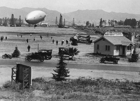
[Image: The now-lost runways of L.A.’s Cecil B. De Mille Airfield; photo courtesy of UCLA’s Re-Mapping Hollywood archive].

The Cecil B. De Mille Airfield, for instance, described by the Re-Mapping Hollywood archive at UCLA as having once stood “on the northwest corner of Wilshire Boulevard and Crescent Avenue (now Fairfax),” would, today, be opposite The Grove; on the southwest corner of the same intersection was Charlie Chaplin Airfield. As their names would indicate, these private (and, by modern standards, extremely small) airports were used by movie studios both for transportation and filming sky scenes. They were aerial back-lots.

Other examples include Burdett Airport, located at the intersection of 94th Street and Western Avenue in what is now Inglewood; the fascinating history of Hughes Airport in Culver City; the evocatively named, and now erased, Puente Hills “Skyranch“; and at least a dozen others, all documented by Paul Freeman’s aero-archaeology site, Abandoned & Little-Known Airfields (four pages alone are dedicated to lost L.A. airfields).

[Image: Charlie Chaplin Airfield in 1920s Los Angeles; photo courtesy of UCLA’s Re-Mapping Hollywood archive].

In a way, though, these airports are like the Nazca Lines of Los Angeles – or perhaps they are even more like Ley lines beneath the city. Laminated beneath 20th century city growth, their forgotten geometries once diagrammed an anthropological experience of the sky, spatial evidence of human contact with the middle atmosphere. Perhaps we should build aerial cathedralry there, to mark these places where human beings once ascended. A winged Calvary.

The cast of minor characters who once crossed paths with those airfields is, itself, fascinating. A minor history of L.A. aviators would include men like Moye W. Stephens. Stephens’s charismatic globe-trotting adventures, flying over Mt. Everest in the early 1930s, visiting Timbuktu by air, and buzzing above the Taj Mahal, would not be out of place in a novel by Roberto Bolaño or an unpublished memoir by Antoine de Saint-Exupéry. And that’s before we really discuss Howard Hughes.
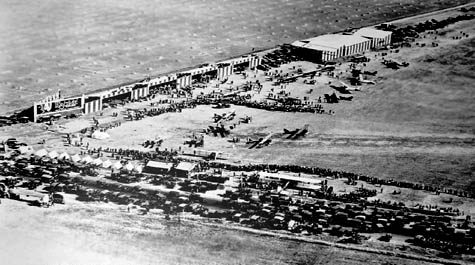
[Image: The Cecil B. De Mille Airfield, renamed Rogers Airport (or, possibly, Rogers Airport, which later became the Cecil B. De Mille Airfield); image via Paul Freeman’s Abandoned & Little-Known Airfields].

Of course, many of these aeroglyphs are now gone, but perhaps their remnants are still detectable – in obscure property law documents at City Hall, otherwise inexplicable detours taken by underground utility cables, or even in jurisdictional disputes at the L.A. fire department.

And they could even yet be excavated.

A new archaeology of airfields could be inaugurated at the corner of Wilshire and Fairfax, where a group of students from UCLA will brush aside modern concrete and gravel to find fading marks of airplanes that touched down 90 years ago, over-loaded with film equipment, in what was then a rural desert.

With trowels and Leica site-scanning equipment in hand, they look for the earthbound traces of aerial events, a kingdom of the sky that once existed here, anchored down at these and other points throughout the L.A. basin, cutting down into the earth to deduce what once might have happened high above.

Interchange Tiles

[Image: Four tiles by Jim Termeer].

“This is a set of 25 ceramic tiles,” artist Jim Termeer explains. “The patterns are based on satellite imagery of major highway interchanges that have been built worldwide.”
So you can decorate your bathroom with the freeways of Barcelona.

[Image: The Barcelona tile, by Jim Termeer].

(Discovered via Mason White, thanks to a tip from Theresa Duncan. If you like these images, meanwhile, be sure to stop by BLDGBLOG’s Return of the Knot Driver and, of course, The Knot Driver

).

Tokyo Secret City

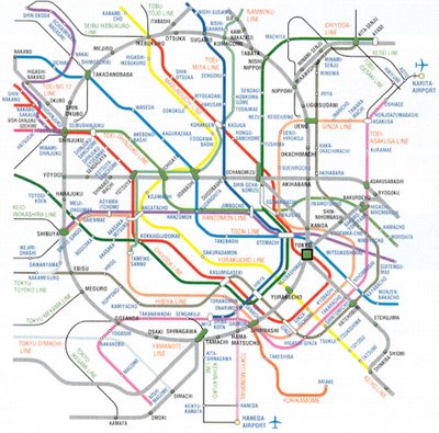
This is an old story, but I still like telling it. Japanese researcher Shun Akiba has apparently discovered “hundreds of kilometers of Tokyo tunnels whose purpose is unknown and whose very existence is denied.”

[Image: From the LOMO Tokyo flickr pool; image by someone called wooooooo].

Shun, who believes he is now the victim of a conspiracy, stumbled upon “an old map in a secondhand bookstore. Comparing it to a contemporary map, he found significant variations. ‘Close to the Diet in Nagata-cho, current maps show two subways crossing. In the old map, they are parallel.'”
This unexpected parallelization of Tokyo’s subway tunnels – a geometrician’s secret fantasy – inspired Shun to seek out old municipal construction records. When no one wanted to help, however, treating him as if he were drunk or crazy – their “lips zipped tight” – he woke up to find his thighs sealed together with a transparent, jelly-like substance –
Er
Actually, he was so invigorated by this mysterious lack of interest that “he set out to prove that the two subway tunnels could not cross: ‘Engineering cannot lie.'”
But engineers can.
To make a long story short, there are “seven riddles” about this underground world, a secret Subtokyo of tunnels; the parallel subways were only mystery number one: “The second reveals a secret underground complex between Kokkai-gijidomae and the prime minister’s residence. A prewar map (riddle No. 3) shows the Diet in a huge empty space surrounded by paddy fields: ‘What was the military covering up?’ New maps (No. 4) are full of inconsistencies: ‘People are still trying to hide things.’ The postwar General Headquarters (No. 5) was a most mysterious place. Eidan’s records of the construction of the Hibiya Line (No. 6) are hazy to say the least. As for the ‘new’ O-Edo Line (No. 7), ‘that existed already.’ Which begs the question, where did all the money go allocated for the tunneling?”
Shun even “claims to have uncovered a secret code that links a complex network of tunnels unknown to the general public. ‘Every city with a historic subterranean transport system has secrets,’ he says. ‘In London, for example, some lines are near the surface and others very deep, for no obvious reason.'” (Though everyone knows the Tube is a weaving diagram for extraterrestrials).


Further, Shun reveals, “on the Ginza subway from Suehirocho to Kanda,” there are “many mysterious tunnels leading off from the main track. ‘No such routes are shown on maps.’ Traveling from Kasumigaseki to Kokkai-gijidomae, there is a line off to the left that is not shown on any map. Nor is it indicated in subway construction records.”
Old underground car parks, unofficial basements, locked doors near public toilets – and all “within missile range of North Korea.”
What’s going on beneath Tokyo?

(Thanks to Bryan Finoki for originally pointing this out to me! For similar such explorations of underground London, see London Topological; and for more on underground Tokyo, see Pillars of Tokyo – then read about the freaky goings-on of Aum Shinrikyo, the subway-gassing Japanese supercult. And if you’ve got information on other stuff like this – send it in…)

Gondolas of New York

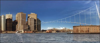
New York City’s Mayor Michael Bloomberg recently announced an interest in building a network of gondolas across New York City.

[Image: Santiago Calatrava].

Well… not quite a “network” – “across New York City” – but one route, “linking Brooklyn to Manhattan by way of Governors Island on a tramway.”
Governors Island, incidentally, is a small island in the New York harbor: “The city and state of New York bought the island in 2002 from the U.S. government for $1. Until 2000, it had been the longest continuously used U.S. military facility, dating back more than 200 years.” $1!

[Image: Governors Island, upper left; Manhattan, upper right. The rest is Brooklyn. The gondola would go zipping back and forth].

In any case, the gondola, “estimated to cost $125 million, would be designed by the architect Santiago Calatrava, and would greatly change the face of Upper New York Bay. But there is a catch,” we read: Bloomberg “acknowledged that the system was still only an idea. He said, however, that he hoped it would eventually become reality and in the meantime inspire others to come up with big ideas for the development of Governors Island.”
Like a Shakespearean theatre?
Well, here’s an idea:
More routes. More gondolas. Gondolas you can rent as a live/work space. Private gondola routes, from high-rise to high-rise, with windows of bulletproof glass. Night-club gondolas. Church confessional gondolas. Flying prison cells, an Alcatraz of the sky, reforming criminals through scenic views.

Different architects and engineering firms should design the gondolas – Foster and Partners, Zaha Hadid, Michael Sorkin, Halcrow, even BLDGBLOG – and they shouldn’t stop there: gondolas linking to gondolas, which in turn link to more gondolas. Gondolas switching through Ferris wheels. Gondolas connecting to the space elevator – which leads upward to gondolas in space… then back to Greenwich Village. Return trip: two hours.
The city could recoup its investment by selling film permits to Hollywood. Die Hard 4.
Gondola greenhouses that follow the sun in a heliocentric circuit round Manhattan, growing mutant flowers.
An airborne hospital for the depressed.
Rumors break out that there is a hidden gondola somewhere, itself unreachable by gondola – Kabbalists and Aristotelians argue that, in fact, this is impossible, citing Maimonides. Entire websites go up, dedicated to finding it.
Folk maps are produced, printed in the back of Time Out, charting the fastest route, the most interesting route, the longest route, the scenic route. A listserv begins, describing gondola hacks: how to make your gondola do a 360º.
You can win the Olympics with it.

[Image: Santiago Calatrava].

Alternatively, forget the gondolas: Governors Island, in its 172-acre entirety, should be uprooted, dismantled, geologically ground-down to soil and dust – then hung from a series of sacks and hammocks off the side of the Empire State Building. Hanging gardens, indeed.