Spaces of Guilt and Innocence

[Image: From “The New London Law Court” by Matthew Turner, Bartlett School of Architecture, Unit 12].

I was in London earlier this month, primarily for another year of external exams at the Bartlett School of Architecture. This consists for the most part in meeting with a large group of students from different design units across the school for one-on-one presentations of their work; much of that work was incredibly interesting and worth sharing here.

[Image: From “The New London Law Court” by Matthew Turner, Bartlett School of Architecture, Unit 12].

This first project is a design for a new London Law Court, by Matthew Turner for Unit 12. The class, taught by Jonathan Hill, Elizabeth Dow, and Matthew Butcher, looked at what it called “the public private house,” with a focus on civic institutions and their relationship to the larger city.

In this case, that institution is a court of law.

[Image: From “The New London Law Court” by Matthew Turner, Bartlett School of Architecture, Unit 12].

The entire project is built around a set of stark spatial polarities set up between public and private, accuser and accused, guilty and innocent.

Circulation—the actual path a visitor might take to pass from one room to another, or from one part of the facility to the next, or even what can or cannot be seen from specific standpoints, such as the witness box or the judge’s robing chambers—is thus the building’s major organizing principle.

It is all about sequence, connection, and adjacency.

[Images: From “The New London Law Court” by Matthew Turner, Bartlett School of Architecture, Unit 12].

Even better, the project is a rigorous exploration of brick, a hugely overlooked material, including micro-studies of structural bricklaying patterns and surface effects.

[Image: Brick patterns from “The New London Law Court” by Matthew Turner, Bartlett School of Architecture, Unit 12].

Turner explained that different surface treatments show up throughout the building almost as a kind of signage or way-finding tool, such that particular patterns come to signify types of interior spaces throughout the complex—a public waiting area, for example, or spaces for the accused.

[Image: From “The New London Law Court” by Matthew Turner, Bartlett School of Architecture, Unit 12].

These pattern-studies are rendered in a style that makes them deeply reminiscent of Auguste Choisy.

[Images: Brick patterns from “The New London Law Court” by Matthew Turner, Bartlett School of Architecture, Unit 12].

Turner really went for it with the axonometry, cutting gorgeous sections through sites of extreme structural complexity that reveal slices of the interior that seem more like Cubist abstractions than actual building plans.

Yet, as his thesis voluminously demonstrates, all of the spaces nonetheless maintain both architectural and narrative coherence.

[Image: From “The New London Law Court” by Matthew Turner, Bartlett School of Architecture, Unit 12].

The passage of light, as can be seen in this next image, is also given symbolic or explanatory weight. As Turner writes, “Distances are compressed and spaces seem to step through each other. Spaces are attenuated, echoed and re-echoed before their sources are experienced. Light in the building does not signify divine truth and justice but instead its shadows and effects are hard to define.”

As they day progresses, the interior is like a clock, and “shadows become spaces within themselves.”

[Image: From “The New London Law Court” by Matthew Turner, Bartlett School of Architecture, Unit 12].

The thesis is immensely detailed, and these selections are barely sufficient as an introduction to Turner’s work. As a study of how architecture itself—that is, the careful and deliberate sequencing of spatial experience—can be used to instill narrative sensations of guilt, resolution, privacy, institutional respect, and so much more, it was really commendable.

[Image: From “The New London Law Court” by Matthew Turner, Bartlett School of Architecture, Unit 12].

I’ll hope to post a few more projects from the Bartlett over the next couple of days.

“The entire city can be considered as one large house”

venice[Image: “St. Mark’s Place, with campanile, Venice, Italy,” via the Library of Congress].

Following a number of recent events for A Burglar’s Guide to the City—discussing, among other things, the often less than clear legal lines between interiors and exteriors, between public space and private—I’ve been asked about the Jewish practice of the eruv.

An eruv, in very broad strokes, is a clearly defined space outside the walls of the private home, often marked by something as thin as a wire, inside of which observant Jews are permitted to carry certain items on Shabbat, a day on which carrying objects is otherwise normally prohibited.

As Chabad describes the eruv, “Practically, it is forbidden to carry something, such as a tallit bag or a prayer book from one’s home along the street and to a synagogue or to push a baby carriage from home to a synagogue, or to another home, on Shabbat.”

However, “It became obvious even in ancient times, that on Shabbat, as on other days, there are certain things people wish to carry. People also want to get together with their friends after synagogue and take things with them—including their babies. They want to get together to learn, to socialize and to be a community.”

While, today, “it is an obvious impracticality to build walls throughout portions of cities, crossing over or through streets and walkways, in order to place one’s home and synagogue within the same ‘private’ domain,” you can instead institute an eruv: staking out a kind of shared private space, or a public “interior,” as it were. The eruv, Chabad continues, is “a technical enclosure which surrounds both private and hitherto public domains,” and it “is usually large enough to include entire neighborhoods with homes, apartments and synagogues, making it possible to carry on Shabbat, since one is never leaving one’s domain.”

In fact, the space of the eruv can absorb truly huge amounts of an existing city, despite the fact that many people will not even know it exists, let alone that they have crossed over into it, that they are “inside” something.

So the question I’ve been posed—although I will defer to more learned colleagues for an informed and accurate answer—is: what does the eruv do to concepts of burglary, if everything taking place inside it, even if technically “outside,” is considered an interior private space? In other words, can any crime committed inside an eruv be considered an act of burglary?

These questions reminded me, in fact, of a commenter named Federico Sanna, who recently pointed out here on the blog that the city of Venice has instituted a new regime for public space in the city by recognizing the entirety of Venice as an eruv.

Reading this with the messy help of Google Translate, the Venetian mayor has signed a law “attesting that the entire city can be considered as one large ‘house,’” or eruv, extending domesticity to the entire metropolis. This eruv will exist for five years, after which, presumably, it will be renewed.

As Sanna points out in his comment, “It must be said: Venice is the place that invented the Ghetto. And this is the 500th anniversary of that event. Venice is the first city to ever constrain Jews in one tiny portion of its urban space–another act that generated architecture, making buildings grow higher and higher to accomodate the growing Jewish population. It is significant, then, if not altogether timely, that it’s Venice that makes this symbolic move of inclusiveness for the first time.”

What effect—if any—this might have on the legal recognition of burglary remains, for me, an interesting question.

Beginning at Arcs, Centered by Lines

[Image: From United States of America, Plaintiff v. State of California,” December 15, 2014].

This is old, old, old news, widely covered elsewhere at the time, but I rediscovered this link saved in my bookmarks and wanted to post it: back in December 2014, the U.S. Supreme Court redefined the maritime border of California with an amazing, 108+ page sequence of numerical locations in space.

It is geodetic code for marking the western edge of state power—or Sol Lewitt’s instructional drawings given the power of sovereign enforceability.

Rather than “The Location of a Trapezoid,” in other words, as Lewitt’s work once explored, this is the location of California.

[Image: From United States of America, Plaintiff v. State of California,” December 15, 2014].

Beyond these mathematically exact limits is not the open ocean, however, but sea controlled by the United States federal government. The coordinates laboriously, hilariously reproduced over dozens and dozens of pages simply define where California’s “Submerged Lands” end, or expanses of seafloor where California has the right to explore for economic resources. Outside those submerged lands, the feds rule.

In a sense, then, this is the Supreme Court seemingly trolling California, tying up the Golden State’s perceived western destiny within a labyrinth of constricting arcs and lines, then claiming everything that lies beyond them.

Lost Highways

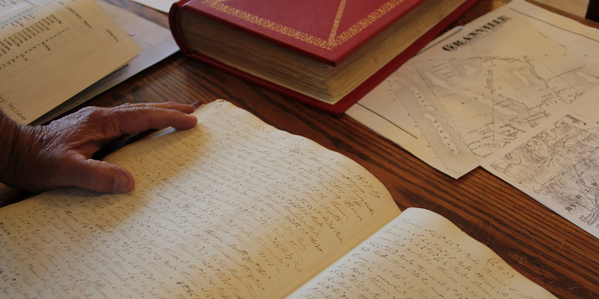
[Image: Reviewing old property deeds and land surveys; photo by Geoff Manaugh].

A story I’ve been obsessed with since first learning about it back in 2008 is the problem of “ancient roads” in Vermont.

Vermont is unusual in that, if a road has been officially surveyed and, thus, added to town record books—even if that road was never physically constructed—it will remain legally recognized unless it has been explicitly discontinued.

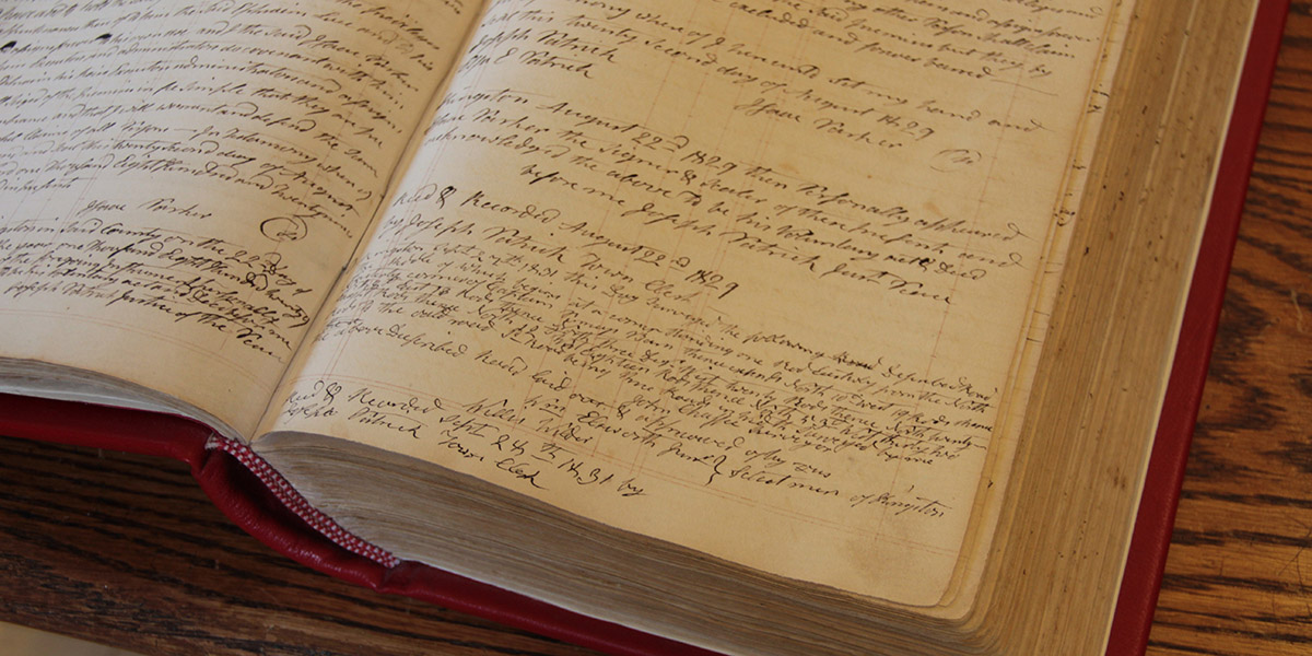
[Image: More Granville property deeds; photo by Geoff Manaugh].

This means that roads surveyed as far back as the 1790s remain present in the landscape as legal rights of way—with the effect that, even if you cannot see this ancient road cutting across your property, it nonetheless persists, undercutting your claims to private ownership (the public, after all, has the right to use the road) and making it difficult, if not impossible, to obtain title insurance.

Faced with a rising number of legal disputes from homeowners, Vermont passed Act 178 back in 2006. Act 178 was the state’s attempt to scrub Vermont’s geography of these dead roads.

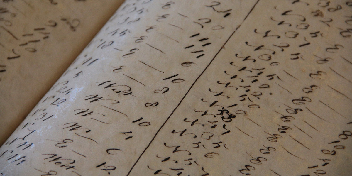
[Image: Geographic coordinates for lost roadways; photo by Geoff Manaugh].

The Act’s immediate effects, however, were to kick off a rush of new research into the state’s lost roadways.

This meant going back through property deeds and mortgage records, dating back to the late 18th-century, deciphering old handwriting, making sense of otherwise location-less survey coordinates, and then reconciling all this with on-the-ground geologic features or local landmarks.

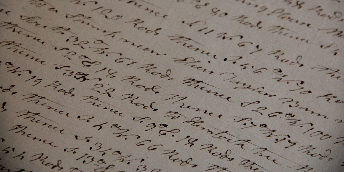
[Image: Zooming into survey descriptions of rods and chains; photo by Geoff Manaugh].

Not every town was enthusiastic about finding them, hoping instead that the old roads would simply disappear.

Other towns—and specific townspeople—responded with far more enthusiasm, as if finding an excuse to rediscover their own histories, the region’s past, and the lives of the other families or settlers who once lived there.

Anything they found and officially submitted for inclusion on Vermont’s state highway map would continue to exist as a state-recognized throughway; anything left undocumented, or specifically called out for discontinuance, would disappear, losings its status as a road and becoming mere landscape.

July 1, 2015, was the deadline, after which anything left undiscovered is meant to remain undiscovered.

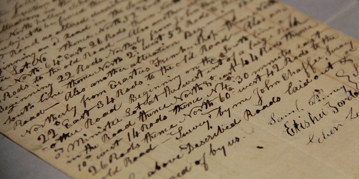
[Image: Ancient road descriptions; photo by Geoff Manaugh].

I had an amazing opportunity to visit the tiny town of Granville, Vermont, ten days ago, where I met with a retired forester and self-enlisted local historian named Norman Arseneault.

Arseneault became so involved in the search for Granville’s ancient roads that he is not only self-publishing an entire book documenting his quest, but he was also pointed out to me as an exemplar of rigor and organization by Johnathan Croft, chief of the Mapping Section at the Vermont Agency of Transportation (where there is an entire page dedicated to “Ancient Roads“).

His hunt for old roads seems to fall somewhere between Robert Macfarlane’s recent work and the old Western trail research of Glenn R. Scott.

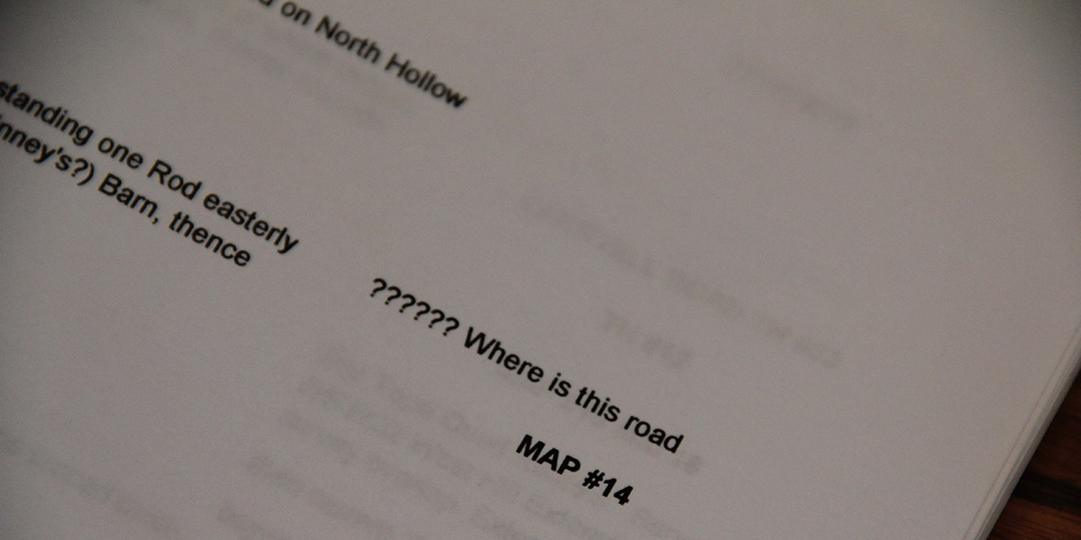
[Image: “?????? Where is this road”; photo by Geoff Manaugh].

While I was there in Granville, Arseneault took me into the town vault, flipping back through nearly 225 years of local property deeds. We then hit the old forest roads in his pick-up truck, to hike many of the “ancient roads” his research had uncovered.

I wrote up the whole experience for The New Yorker, and I have to say it was one of the more interesting article research processes I’ve ever been involved with; check it out, if any of this sounds of interest.

It’s worth pointing out, meanwhile, that the problem of “ancient roads” is not, in fact, likely to go away; the recent introduction of LiDAR data, on top of some confusingly written legal addenda, make it all but certain that other property owners will yet find long-forgotten public routes crossing their land, or that a future private development count still find its unbuilt plots placed squarely atop invisible roads made newly available to town use.

The hows and whys of this are, I hope, explained a bit more over at The New Yorker.

The Permission We Already Have

[Image: Courtesy of David Knight and Finn Williams].

David Knight and Finn Williams have been investigating what they call “minor development” in the field of architecture and urban planning for several years now, and their discoveries are absolutely fascinating. Last year they published a book called SUB-PLAN: A Guide to Permitted Development, exploring the world of building extensions, temporary structures, outdoor spaces, and other minor acts of home construction that fly beneath the radar of official town planning.

“How far does planning control what we build? And what can we build without planning?” the authors ask. “SUB-PLAN explores the legal possibilities of building outside the limits of legislation.”

The UK planning system has been swamped by minor applications for household extensions and outbuildings that cause a backlog of bureaucracy and dominate the limited resources of local planning authorities. On 1 October 2008 the government introduced changes to the General Permitted Development Order 2 to reduce the number of minor applications by expanding the definition of what can be built without planning permission.

But, they add, “are the implications of minor development more significant than planners imagine?”

[Images: Courtesy of David Knight and Finn Williams].

Knight and Williams will be participating in a public conversation next week in London, sponsored by the Architecture Foundation; called Permitted Development: The Planning Permission We Already Have, it will be an example of what we might call legislative forensics, looking into the law books—and the urban planning guidelines—to see what architectural possibilities already exist in the present day for residents to explore.

In that previous sentence, I almost wrote “for residents and homeowners to explore”—but I wonder if you really need to be a homeowner to take advantage of these unpublicized zones of building permission? Is simply being a citizen enough, or must you own property to participate in the realm of minor architecture? Or is there even an unacknowledged world of building practices legally open to construction by non-citizens—by people who, legally speaking, reside nowhere?

In the intersection between architecture and permission, what spaces are possible and who has the right to realize them? What are the possibilities for architectural insurrection—or, at the very least, aesthetic experimentation?

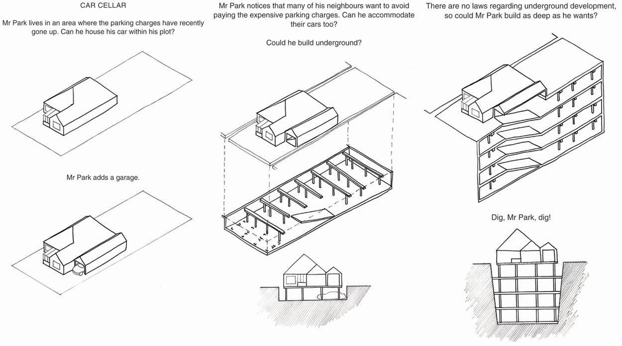
[Image: An awesome glimpse of “the permission we already have,” courtesy of SUB-PLAN by David Knight and Finn Williams; view larger].

In Sweden, for instance, there is a type of small garden shed known as the friggebod, named after Birgit Friggebo, Sweden’s former housing minister. “The term is a wordplay based on the common term bod: (tool) shed; shack,” Wiktionary explains. “The friggebod reform implied that anyone could build a shed of maximum 10 square meters on their premises without obtaining a construction permit from the municipality. In Sweden, the reform became a widely popular symbol of liberalization. From the onset of 2008, the area was increased to 15 square meters.”

These autonomous planning zones, so to speak, open up architectural production to non-architects in a possibly quite radical way. So how do we take advantage of them?

[Images: Another mind-bending example of “the permission we already have,” courtesy of SUB-PLAN by David Knight and Finn Williams].

Next week’s event in London bills itself as follows:

Though apparently at the humble end of the planning system, recent changes to Permitted Development rights are a treasure trove of architectural potential. The new breed of lean-tos, loft conversions, sheds and summerhouses they allow could have far-reaching and surprising consequences for UK towns and countryside. Finn Williams and David Knight will present recent projects which explore and exploit Permitted Development rules.

I’d love to hear how this goes, in case anyone there can report back. To be honest, I think this type of research is both jaw-dropping and urgently needed elsewhere. What unknown architectural permissions exist for the residents of Manhattan, LA, Beijing, São Paulo…?

What future DIY architectures have yet to arise around us—and when will we set about constructing them?