A narrative from the swamps of Borneo

[Image: London’s sewers under construction; via the fascinating Sewer History site].

At one point in his recent overview of all things under London, from plague pits to bank vaults and buried rivers to Cold War government bunkers, author Peter Ackroyd quips that descriptions of the humid and microbiologically overgrown tunnels of the city’s sewers “might be a narrative from the swamps of Borneo rather than the City of London.”

[Image: Courtesy of Sewer History].

In a chapter appropriately called “Heart of Darkness”—”this was the heart of darkness,” Ackroyd writes, “the lowest depth of a city that was already being described as a wilderness”—Ackroyd introduces us to several centuries’ worth of sewer work, including the “flushers” or hardy laborers hired to enter the tunnels physically and help push—or “flush”—the waste out from sites of stagnation.

[Image: A “flusher,” courtesy of Sewer History; for those of you interested in the state of “flushing” today, don’t miss Edible Geography‘s interview with Julio the sewer diver, or this look at “fatbergs” in London].

Bizarrely, but somehow fittingly, these sewers always seem to remain imperfectly mapped, with no one person or government office in particular possessing a full chart or atlas of all the twisty passages.

This unmapped condition has, of course, at various times in history, necessitated a survey.

[Image: Courtesy of Sewer History].

“A survey of the sewers of London was undertaken in the summer and autumn of 1848,” Ackroyd writes, “when their condition was described as ‘frightful’; the system was dilapidated and decayed, even dangerous.”

Workers sent below encountered titanic rooms dripping with grotesque stalactites made from human waste, mushrooms nearly “as large as ordinary soup-tureens” growing on the brickwork, and such poor and unventilated air that some surveyors had to be “dragged out… in a state of insensibility.”

[Image: Great iron doors beneath the city; courtesy of Sewer History].

This only increased the sense of near-unearthly wonder that colored popular descriptions of the city’s artificial underworld: “The reports of the world beneath are written in a generally breathless tone, compounded of fear and awe.”

The underground chambers are compared to cathedrals, complete with pillars and buttresses, arches and crypts. One visitor, discovering an archway through which a cataract tumbled, remarked that it was as fantastic a scene as ‘a dream of a subterranean monastery.’ The travelers walk along tunnels that may reach a height of 17 feet, the cool tainted water lapping at about knee-height around their waders. Many are disconcerted by the pull of the water, and feel disoriented; they lose their equilibrium. They feel the sediment beneath their feet, as if they were walking on a beach at low tide. Great iron doors loom up at intervals, actings as valves. The noise of roaring water, somewhere in the distance, can generally be heard. It is the sound of cataracts and waterfalls.

It is here, on this literal beach beneath the streets, that Ackroyd makes the tropical implications most explicit, where a landscape more like “the swamps of Borneo” is discovered, an urban tropics, steaming and wild under London.

Fire-Walking New York City

[Image: Combustible City by Common Room].

The New York-based group Common Room will soon be publishing and displaying in their space a series of walks around the city, walks that, in their words, “demonstrate, at four different spatial scales, the agency of combustion in shaping the city’s architecture, infrastructure and imaginary [sic].”

Devised and authored by Adam Bobbette, the tours will include sites and experiences such as walking “the perimeter of the great fire of 1835,” exploring the “former sites of fire towers in Manhattan,” and more:

Additionally, the tours recount the history of the fireproof building, the epistemological relationships between panoramas, hot air balloons and fire towers, the changing shape of water in the city, and the hyperreality of prevention. Together, these tours reveal another city nested within New York City, a city in plain view but rarely considered; this city is constituted by and through the management and care for its own inherent fragility, this city is named Combustible City.

I’m reminded of a recent book on my wishlist for the summer: Flammable Cities: Urban Conflagration and the Making of the Modern World by Greg Bankoff, which describes itself as “the first truly global study of urban conflagration.” Bankoff “shows how fire has shaped cities throughout the modern world, from Europe to the imperial colonies, major trade entrepôts, and non-European capitals, right up to such present-day megacities as Lagos and Jakarta. Urban fire may hinder commerce or even spur it; it may break down or reinforce barriers of race, class, and ethnicity; it may serve as a pretext for state violence or provide an opportunity for displays of state benevolence. As this volume demonstrates, the many and varied attempts to master, marginalize, or manipulate fire can turn a natural and human hazard into a highly useful social and political tool.”

Bobbette’s fire walks of New York City will be on display at Common Room from July 16-August 16, and I believe more information will be available soon on their website.

(Previously on BLDGBLOG: The Fires. Thanks to Carlos Solis for the tip!)

Fields of the Future

Peter Brewer, an ocean chemist at Monterey, is working on what Nature Climate Change calls an “underwater aquarium.”

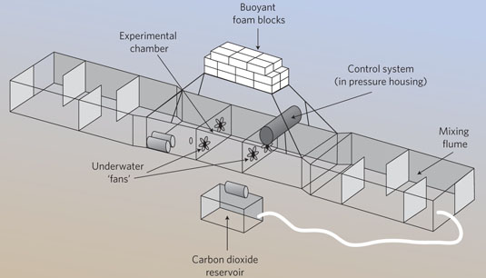
[Image: A diagram of Peter Brewer’s “underwater aquarium,” via Nature Climate Change].

It is, Brewer explains, “a 10m-long flume with an experimental chamber that sits on a patch of sea floor containing animals whose response to ocean acidification is to be tested.”

Brewer’s artificial chemical microclimate—a partially enclosed carbon dioxide bloom—is framed by an architecture of buoyant bricks and mixing fans. “At present, it is on the sea floor about 850m below the ocean surface and 25km offshore,” he adds.

The use of this technically enhanced architectural device to test undersea creatures—with its M.C. Escher-like logic of an aquarium surrounded by water—brings to mind other experiments for spatially probing the limits of life, including modified-atmosphere aviaries or even the Duke Forest, a forest-within-the-forest dotted with carbon dioxide-emitting masts.

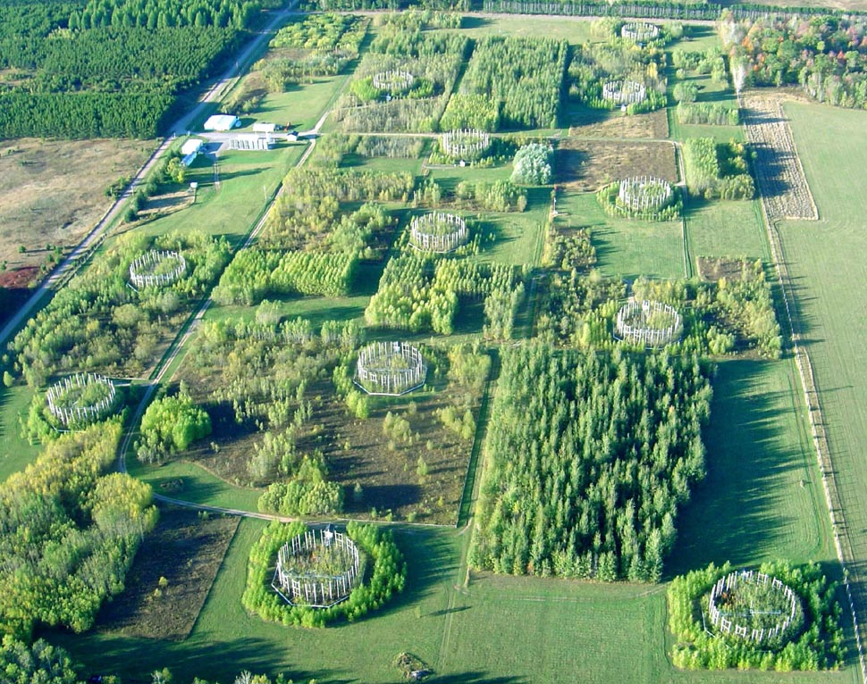
[The “Aspen FACE,” or Northern Forest Ecosystem Experiment].

The Northern Forest Ecosystem Experiment in Wisconsin, pictured above, is another example of using spatial tools to frame and demarcate an augmented ecosystem.

Further, there is an interestingly asynchronous quality to these experimental terrains: in each case, they are technically enhanced landscapes for the production of a speculative future biome, these and other “fields of the future” simulating what regions of the earth might be like in 50-100 years’ time.

Urban Target Complex National Monument

[Image: Yodaville, via Google Maps].

Yodaville is a fake city in the Arizona desert used for bombing runs by the U.S. Air Force. Writing for Air & Space Magazine back in 2009, Ed Darack wrote that, while tagging along on a training mission, he noticed “a small town in the distance—which, as we got closer, proved to have some pretty big buildings, some of them four stories high.”

As towns go, this one is relatively new, having sprung up in 1999. But nobody lives there. And the buildings are all made of stacked shipping containers. Formally known as Urban Target Complex (R-2301-West), the Marines know it as “Yodaville” (named after the call sign of Major Floyd Usry, who first envisioned the complex).

As one instructor tells Darack, “The urban layout is actually very similar to the terrain in many villages in Iraq and Afghanistan.”

The Urban Target Complex, or UTC, was soon “lit up with red tracer rounds and bright yellow and white rocket streaks,” till it “looked like it was barely able to keep standing”:

The artillery and mortars started firing, troops advanced toward the target complex, and aircraft of all types—carefully controlled by students on the mountain top—mounted one attack run after another. At one point so much smoke and dust filled the air above the “enemy” that nothing could be seen of the target—just one of the real-world problems the students had to learn to cope with that day.

In a recent article for the Tate, writer Matthew Flintham explores “the idea of landscape as an extension of the military imagination.” Referring specifically to the UK, he adds that what he perceives as a contemporary “lack of artistic engagement with the activities of the Ministry of Defence (MoD) is perhaps principally due to the relative segregation of defence personnel, land and airspace from the civil domain.”

Flintham points out—again, referring to the UK—that “today’s MoD has its own vast training estate with numerous barracks and an enormous stock of housing, all of which are detached from public scrutiny. The public are prevented from accessing many areas of the defence estate for two reasons: the extreme danger of live weapons and hazardous activities (and related issues of potential litigation), and the restrictions on privileged, strategic or commercial information in the interests of national security.” This has the effect that these sorts of military landscapes not only fall outside critical scrutiny—and also remain, with very few exceptions, all but invisible to architectural critique—but that their only real role in the public imagination is entirely speculative, often based solely on rumor and verging on conspiracy.

While Flintham thus calls for a more active artistic engagement with military landscapes, exploring what he calls the “military-pastoral complex,” I would echo that with a related suggestion that spaces such as Yodaville belong on the architectural itinerary of today’s design writers, critics, and students.

Given the mitigation of the very obvious problems Flintham himself points out—such as site contamination, unexploded ordnance, and national security leaks—it would be thrilling to see a new kind of “fortifications tour,” one that might bring these sorts of facilities into the public experience.

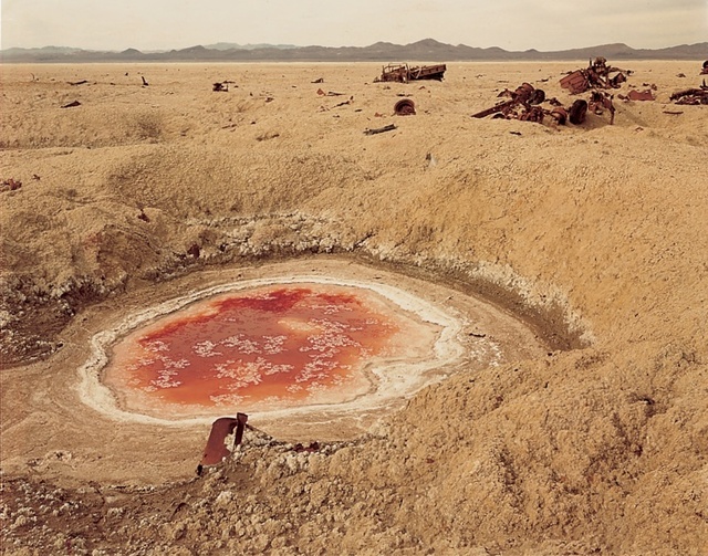
[Image: Photo by Richard Misrach, courtesy of the Whitney Museum of American Art, from Bravo 20].

An interesting possibility for this sort of national refocusing on military landscapes comes from artists Richard and Myriam Misrach. The Misrachs have proposed a “Bravo 20 National Park“—that is, “turning the blasted range into a National Park of bombing,” as the Center for Land Use Interpretation phrases it. “When the Navy’s use of Bravo 20 was up for Congressional review in 1999,” CLUI continues, “Misrach made one more heroic, quixotic, and failed attempt to get his proposal seriously considered. Instead, the Navy has increased its use of Bravo 20, and the four other ranges around Fallon, and has been authorized to expand their terrestrial holdings in the area by over 100,000 acres.”

So what, for instance, might something like a Yodaville National Park, or Urban Target Complex National Monument, look like? How would it be managed, touristed, explored, mapped, and understood? What sorts of trails and interpretive centers might it host? Alternatively, in much the same way that the Unabomber’s cabin is currently on display at the Newseum in Washington D.C., could Yodaville somehow, someday, become part of a distributed collection of sites owned and operated by the Smithsonian, the National Building Museum, or, for that matter, UNESCO, in the latter case with Arizona’s simulated battlegrounds joining Greek temples as world heritage sites?

In any case, bringing spaces of military simulation into the architectural discussion, and reading about Yodaville in, say, Architectural Record instead of—or in addition to—Air & Space Magazine, would help to demystify the many, otherwise off-limits, landscapes produced (and, of course, destroyed) by military activity. Better, this would reveal even the cloudiest of federal lands as spatial projects, nationally important places that—again, given declassification and appropriate environmental remediation—might hold unexpected insights for design practitioners, let alone for critics, the public, and national historians.

(Thanks to Mark Simpkins for the Tate link).

Various forms of lithic disguise

I finally had a chance to read John McPhee’s book La Place de la Concorde Suisse, his somewhat off-puttingly titled 1984 look at the Swiss military and its elaborately engineered landscape defenses.

[Image: Swiss mountain pass, via Google Image Search].

To make a long story short, McPhee describes two things: how Switzerland requires military service from every able-bodied male Swiss citizen—a model later emulated and expanded by Israel—and how the Swiss military has, in effect, wired the entire country to blow in the event of foreign invasion. To keep enemy armies out, bridges will be dynamited and, whenever possible, deliberately collapsed onto other roads and bridges below; hills have been weaponized to be activated as valley-sweeping artificial landslides; mountain tunnels will be sealed from within to act as nuclear-proof air raid shelters; and much more.

First, a quick look at the system of self-demolition that is literally built into the Swiss national infrastructure:

To interrupt the utility of bridges, tunnels, highways, railroads, Switzerland has established three thousand points of demolition. That is the number officially printed. It has been suggested to me that to approximate a true figure a reader ought to multiply by two. Where a highway bridge crosses a railroad, a segment of the bridge is programmed to drop on the railroad. Primacord fuses are built into the bridge. Hidden artillery is in place on either side, set to prevent the enemy from clearing or repairing the damage.

Further:

Near the German border of Switzerland, every railroad and highway tunnel has been prepared to pinch shut explosively. Nearby mountains have been made so porous that whole divisions can fit inside them. There are weapons and soldiers under barns. There are cannons inside pretty houses. Where Swiss highways happen to run on narrow ground between the edges of lakes and to the bottoms of cliffs, man-made rockslides are ready to slide.

The impending self-demolition of the country is “routinely practiced,” McPhee writes. “Often, in such assignments, the civilian engineer who created the bridge will, in his capacity as a military officer, be given the task of planning its destruction.”

But this is where a world of weirdly fascinating artifice begins. After all, McPhee writes, why would Switzerland want anyone to know where the dynamite is wired, where the cannons are hidden, which bridges will blow, or where to find the Army’s top secret mountain hideaways and resupply shelters? But if you look closely, you start to see things.

Through locked gates you see corridors in the sides of mountains—going on and on into the rock, with a light in the ceiling every five meters and far too many to count… Riding around Switzerland with these matters in mind—seeing little driveways that blank out in mountain walls, cavern entrances like dark spots under mountainside railroads and winding corniches, portals in various forms of lithic disguise—you can find it difficult not to imagine that almost anything is a military deception, masking a hidden installation.

Indeed, at one point McPhee jokes that his local guide in Switzerland “tends to treat the army itself as if it were a military secret.”

[Image: Swiss bridge, photographed by Aaron Plewke].

McPhee points to small moments of “fake stonework, concealing the artillery behind [them],” that dot Switzerland’s Alpine geology, little doors that will pop open to reveal internal cannons that will then blast the country’s roads to smithereens. Later, passing under a mountain bridge, McPhee notices “small steel doors in one pier” hinting that the bridge “was ready to blow. It had been superceded, however, by an even higher bridge, which leaped through the sky above—a part of the new road to Simplon. In an extreme emergency, the midspan of the new bridge would no doubt drop on the old one.”

It’s a strange kind of national infrastructure, one that is at its most rigorously functional—one that truly fulfills its promises—when in a state of cascading self-imposed collapse.

I could easily over-quote my way to the end of my internet service here, but it’s a story worth reading. There are, for instance, hidden bomb shelters everywhere in an extraordinary application of dual-use construction. “All over Switzerland,” according to McPhee, “in relatively spacious and quiet towns, are sophisticated underground parking garages with automatic machines that offer tickets like tongues and imply a level of commerce that is somewhere else. In a nuclear emergency, huge doors would slide closed with the town’s population inside.”

[Image: Switzerland’s Gotthard Tunnel, via genevalunch.com].

Describing titanic underground fortresses—”networks of tunnels, caverns, bunkers, and surface installations, each spread through many tens of square miles”—McPhee briefly relates the story of a military reconnaissance mission on which he was able to tag along, involving a hydroelectric power station built inside a mountain, accessible by ladders and stairs; the battalion tasked with climbing down into it thus learns “that if a company of soldiers had to do it they could climb the mountain on the inside.”

In any case, the book‘s vision of the Alps as a massively constructed—or, at least, geotechnically augmented and militarily amplified—terrain is quite heady, including the very idea that, in seeking to protect itself from outside invaders, Switzerland is prepared to dynamite, shell, bulldoze, and seal itself into a kind of self-protective oblivion, hiding out in artificially expanded rocky passes and concrete super-basements as all roads and bridges into and out of the country are instantly transformed into landslides and dust.

Primary Landscapes

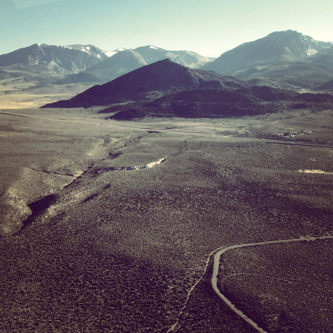
[Image: Around Mono Lake, photo by BLDGBLOG].

The last week has been pretty slow here as we get Venue up and running; but there are some new posts over at the Venue website that I think are worth checking out.

One is a brief, image-heavy round-up from an amazing flight I took last week with photographer Michael Light in his two-seater, fiber-glass aircraft around the shore of Mono Lake, California. A full-length interview with Light is forthcoming, as well.

The other is an interview with photographer Edward Burtynksy, who we had the pleasure of meeting last week at the Nevada Museum of Art for Venue’s inaugural interview. Among discussions of Burtynsky’s most recent series, Oil—which just opened at the Nevada Museum of Art—and the ongoing Water project, we asked Burtynsky about the more technical side of his work, including the deployment of drones in photographing otherwise inaccessible sites, and the somewhat puzzled reactions his work has received from people working in the industries he photographs.

Check those out if you get a chance, and new posts will also appear here on BLDGBLOG soon.

Perpetual Architecture

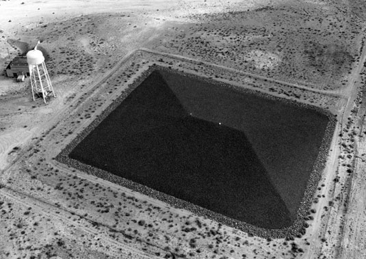
[Image: A “disposal cell,” also visible on Google Maps, courtesy of CLUI].

It’s always welcome news around here when a new exhibition opens up at the Center for Land Use Interpretation—even though, in this case, it displaces the excellent historical look at U.S. federal surveying with the Initial Points: Anchors of America’s Grid show.

On display now is Perpetual Architecture, which explores “uranium disposal cells in the southwest,” constructed “primarily to contain radioactive contamination from decommissioned uranium mills and processing sites. They are time capsules, of sorts, designed to take their toxic contents, undisturbed, as far into the future as possible.” More info, including visiting hours and location, is available at the CLUI website.

Meanwhile, those of you interested in this sort of thing might enjoy BLDGBLOG’s earlier interview with Abraham van Luik, a geoscientist with the U.S. Department of Energy who described in great detail the process by which sites are chosen for the task of isolating nuclear waste over geological timescales.

Venue


I’m excited to be launching a new project called Venue, a 16-month collaboration with the Nevada Museum of Art‘s Center for Art + Environment and Future Plural, the small publishing and curatorial group I’m a part of with Nicola Twilley.

We kick things off this Friday, June 8, with a launch event at the Nevada Museum of Art in downtown Reno, from 6-8pm; if you’re near Reno, consider stopping by!

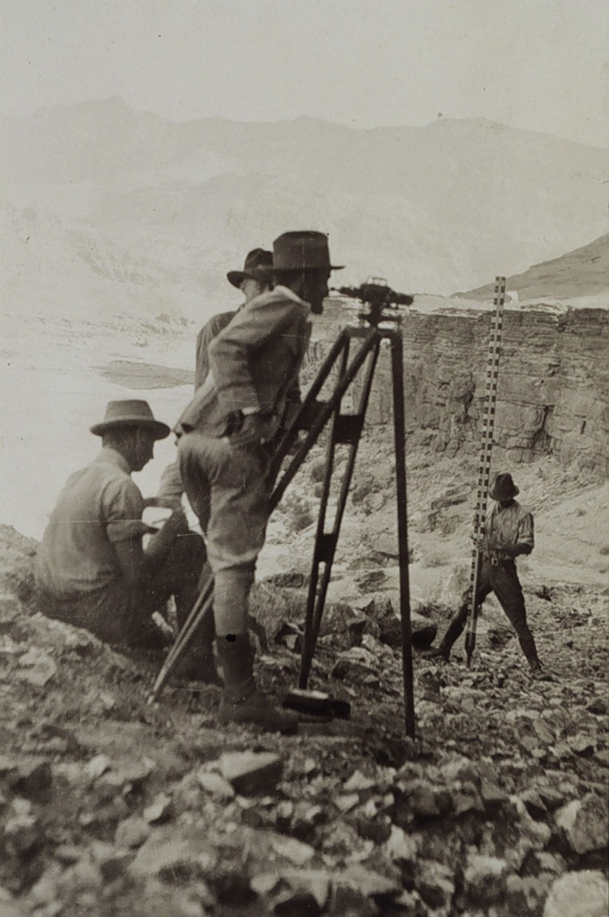
[Image: The tools and props of surveying; courtesy of the USGS].

In brief, Venue is equal parts surveying expedition and forward-operating landscape research base, a DIY interview booth and media rig that will pop up at sites across North America through September 2013.

Nicola Twilley and I will be traveling on and off, in a series of discontinuous trips, over the next 16 months, visiting a variety of sites including infrastructural landmarks, science labs, factories, film sets, archaeological excavations, art installations, university departments, design firms, National Parks, urban farms, corporate offices, studios, town halls, and other locations across North America, where we’ll both record and broadcast original interviews, tours, and site visits. From architects to scientists and novelists to mayors, from police officers to civil engineers and athletes to artists, Venue’s interview archive will form a cumulative, participatory, and media-rich core sample of the greater North American landscape.

[Image: Understanding landscapes by way of strange devices; courtesy of the USGS].

While there will no doubt be regular updates here on BLDGBLOG, you can follow along, both online and off, by reading our latest dispatches, suggesting sites and people we should visit, and keeping an eye on our schedule (or signing up for our mailing list) to find out when we will be bringing Venue to a neighborhood near you. In addition, our best content will be syndicated on a dedicated channel online by The Atlantic, so keep your eye out for our first interviews or site visits—photos, short films, MP3s—as our travels get underway.

[Image: The Venue tripods, universal mounts for interchangeable devices; designed by Chris Woebken].

There’s a lot more information available about the project at the Venue website—including some early images depicting the incredible array of devices designed for us by Chris Woebken, a gorgeous hand-made interview box custom-fabricated for Venue by Semigood, and the “Descriptive Camera” that we’ll have on the first leg of our trip—so by all means stop by and see the ideas behind the project, from conceptual inspiration taken from historical survey expeditions to Ant Farm’s Media Van.

[Image: The Venue box takes shape, custom-designed by Semigood].

And hopefully somewhere down the line, we can meet many of you in person.

Buncefield Bomb Garden

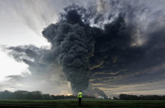
[Image: The Buncefield explosion, via the BBC].

In one of the more interesting landscape design stories I’ve read this year, New Scientist reported back in March that the massive, December 2005 explosion at a fuel-storage depot called Buncefield in England, might have been strongly assisted by the site’s landscaping.

“A few years ago no one would have predicted that a row of trees and shrubs could make the difference between a serious fire and a catastrophic explosion,” the magazine suggests. But now, it’s becoming a reasonably accepted notion that the physical layout of the Buncefield site’s plantlife—from the “shrubs and small trees” down to their individual “twigs and branches”—can work to contain and concentrate, and, worse, add explosive surface area to what would otherwise have simply been a gas leak.

Indeed, the ongoing investigation at Buncefield “might change the way storage depots, refineries and pipelines are designed, and how the sites are landscaped [emphasis added]. Along with conventional safety features like sensors and alarms, site operators may have to rethink the way that trees, hedges and shrubs are positioned.” Investigators have concluded that “even structures on nearby commercial developments could help to accelerate a flame,” meaning that, in the design of any landscape, from industrial parks to corporate lawns, there is a previously unknown capacity for detonation.

What’s incredible about this—if proven true—is that the potentially explosive landscaping of sites such as Buncefield might suggest, according to New Scientist, new geometries or diagrammatic possibilities for the design of jet engines, in particular “a novel aircraft propulsion system called a pulse detonation engine.” The garden as jet engine!

Putting this into the context of other landscape typologies, such as ritual gardens or sacred groves—as if we might someday have orchards that churn and pulse with controlled coils of fire, like the engine of some vast arboreal machine—makes this terrifying topographical phenomenon seem all the more mythic and extraordinary.

(Previously on BLDGBLOG: Star Garden).

Buy an Underground Kingdom

[Image: The Mole Man’s house in Hackney, via Wikipedia].

As most anyone who’s seen me give a talk over the past few years will know, I have a tendency to over-enthuse about the DIY subterranean excavations of William Lyttle, aka the Mole Man of Hackney.

Lyttle—who once quipped that “tunneling is something that should be talked about without panicking”—became internationally known for the expansive network of tunnels he dug under his East London house. The tunnels eventually became so numerous that the sidewalk in front of his house collapsed, neighbors began to joke that Lyttle might soon “come tunnelling up through the kitchen floor,” and, as a surveyor ominously relayed to an English court, “there is movement in the ground.”

From the Guardian, originally reported back in 2006:

No one knows how far the the network of burrows underneath 75-year-old William Lyttle’s house stretch. But according to the council, which used ultrasound scanners to ascertain the extent of the problem, almost half a century of nibbling dirt with a shovel and homemade pulley has hollowed out a web of tunnels and caverns, some 8m (26ft) deep, spreading up to 20m in every direction from his house.

What did he store down there? After Lyttle was forced from the house for safety reasons, inspectors discovered “skiploads of junk including the wrecks of four Renault 4 cars, a boat, scrap metal, old baths, fridges and dozens of TV sets stashed in the tunnels.”

But now the late Mole Man’s home is for sale.

[Image: An earlier Mole Man: Tunnel-Digging as a Hobby].

Alas, “most of the tunnels have been filled in” with concrete, and the house itself is all but certain to be torn down by its future owner, but I like to think that maybe, just maybe, some strange museum of subterranea could open up there, in some parallel world, complete with guided tours of the excavations below and how-to evening classes exploring the future of amateur home excavation. Curatorial residencies are offered every summer, and underground tent cities pop-up beneath the surface of the capital city, lit by candles or klieg lights, spreading out a bit more each season.

Briefly, I’m reminded of a scene from Georges Perec’s novel Life: A User’s Manual, in which a character named Emilio Grifalconi discovers “the remains of a table” that he hopes to salvage for use in his own home. “Its oval top, wonderfully inlaid with mother-of-pearl, was exceptionally well preserved,” Perec explains, “but its base, a massive, spindle-shaped column of grained wood, turned out to be completely worm-eaten. The worms had done their work in covert, subterranean fashion, creating innumerable ducts and microscopic channels now filled with pulverized wood. No sign of this insidious labor showed on the surface.”

Grifalconi soon realizes that “the only way of preserving the original base—hollowed out as it was, it could no longer suport the weight of the top—was to reinforce it from within; so once he had completely emptied the canals of the their wood dust by suction, he set about injecting them with an almost liquid mixture of lead, alum and asbestos fiber. The operation was successful; but it quickly became apparent that, even thus strengthened, the base was too weak”—and the table would thus have to be discarded.

At which point, Grifalconi has an idea: he begins “dissolving what was left of the original wood” in the table’s base in order to “disclose the fabulous arborescence within, this exact record of the worms’ life inside the wooden mass: a static, mineral accumulation of all the movements that had constituted their blind existence, their undeviating single-mindedness, their obsinate itineraries; the faithful materialization of all they had eaten and digested as they forced from their dense surroundings the invisible elements needed for their survival, the explicit, visible, immeasurably disturbing image of the endless progressions that had reduced the hardest of woods to an impalpable network of crumbling galleries.”

Somewhere beneath a new building in East London, then, some handful of years from now, the Mole Man’s “fabulous arborescence” will still be down there, a vast and twisting concrete object preserved in all its tentacular sprawl, like some unacknowledged tribute to Rachel Whiteread: a buried and elephantine sculpture that shows up on radar scans of the neighborhood, recording for all posterity “the endless progressions” of Lyttle’s eccentric and mysterious life.

(Via @SubBrit. Earlier adventures in real estate on BLDGBLOG: Buy a Prison, Buy a Tube Station, Buy an Archipelago, Buy a Map, Buy a Torpedo-Testing Facility, Buy a Silk Mill, Buy a Fort, Buy a Church,).

O.P. Tree

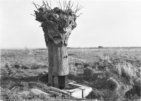
[Image: An exemplary “Observation Post Tree” via the Australian War Memorial].

The “O.P. Tree” was an Observation Post Tree deployed during World War I. Its “goal,” as author Hanna Rose Shell explains in Hide and Seek, her newly published history of the relationship between camouflage and photography, “was to craft a mimetic representation of a tree—and not just any tree, but a particular tree at a specific site” on the European battlefield.

The design, fabrication, and, perhaps most interestingly, installation of this artificial plant form had a fascinating and somewhat Truman Show-esque quality:

To develop the O.P. Tree, Royal Engineers representatives selected, measured, and photographed the original tree, in situ, extensively. The ideal tree was dead; often it was bomb blasted. The photographs and sketches were brought back to the workshop, where artists constructed an artificial tree of hollow steel cylinders, but containing an internal scaffolding for reinforcement, to allow a sniper or observer to ascend within the structure. Then, under the cover of night, the team cut down the authentic tree and dug a hole in the place of its roots, in which they placed the O.P. Tree. When the sun rose over the field, what looked like a tree was a tree no longer; rather, it was an exquisitely crafted hunting blind, maximizing personal concealment and observational capacity simultaneously.

You can see photographs, read about the construction of replicant bark, and even learn that some of the trees were internally upholstered—like wartime superfurniture—as snipers sometimes relied on cushions to assist with long periods of sitting, over at the Australian War Memorial.

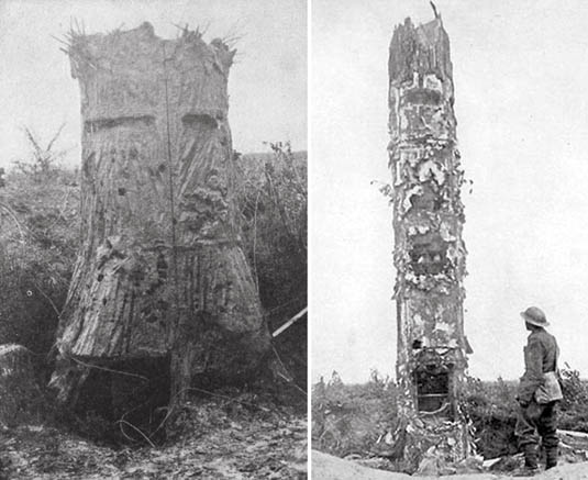
[Image: O.P. Trees].

But there’s something almost comedically paranoid about the idea that, upon waking up tomorrow morning, a tree—or rock or, for that matter, a whole hillside—has been surreptitiously replaced by an artificial surrogate, an exactly designed stand-in or double, in a ruse about which you otherwise remain unaware. It happens again—and again, perhaps for an entire season—before one day you finally stumble upon incontrovertible evidence that the entire forest through which you hike every weekend has been filled with incredibly precise, hollow representations of trees through which someone appears to be spying on you.

(For those of you interested in where the state of fake trees and other artificial landforms is today, consider watching this video of George Dante, founder of Wildlife Preservations, present his firm’s work at Studio-X NYC).