 [Image: A ruined dock at the Philadelphia Lazaretto; photo by David Barnes].
David Barnes is associate professor of the History and Sociology of Science at the University of Pennsylvania, where he focuses on medicine and public health. His most recent research project involves the Philadelphia Lazaretto, a 19th-century quarantine station located on an island in the Delaware River.
As part of our ongoing series of quarantine-themed interviews, Nicola Twilley of Edible Geography and I spoke to Barnes about the origins and history of the now-abandoned Lazaretto, including ongoing attempts to preserve the site today. In the process, our conversation covers the legal nature of Colonial-era quarantine, the cultural impact of epidemic disease, and the psychological effects of involuntary medical isolation,
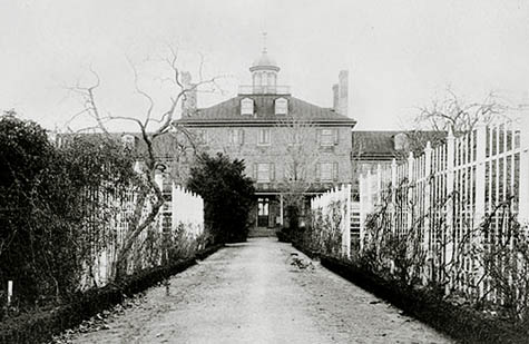 [Image: The Philadelphia Lazaretto, via Wikipedia].
BLDGBLOG: How did you first get into the study of quarantine, and specifically of the Philadelphia Lazaretto?
David Barnes: The history of quarantine was actually not my idea of a burning historiographical problem. In fact, I was working on two completely different projects when I first saw the Lazaretto—but the sight of it just really stuck in my mind. I decided to read everything that had been written about the history of this place—but I soon found that essentially nothing had been written, in a city where it seems like half the buildings in Center City have two or three books written about their history. This is the oldest surviving quarantine facility in the Western hemisphere, and the seventh oldest in the world—and almost nothing has been written about its history.
BLDGBLOG: Why do you think it’s been so overlooked?
Barnes: I don’t really know. I don’t have a good answer for that, even though I’ve asked myself that question many times. It’s possible that it’s just an accident, and the right person at the right time simply hasn’t come along. On the other hand, I wouldn’t say that the history of quarantine is a large, robust subfield of the history of medicine. Generally, historians have written about specific diseases or specific outbreaks; in many of those works, quarantine figures only fairly marginally.
 [Image: Philadelphia’s abandoned Lazaretto as it now stands, photographed by David Barnes].
Edible Geography: Can you describe the Philadelphia Lazaretto, and tell us something of what you have found out about it?
Barnes: Sure. The first law relating to quarantine in Pennsylvania was signed by William Penn in 1700, in response to an epidemic of yellow fever in 1699 in Philadelphia. Philadelphia was founded by William Penn and his gang in 1682, of course—so yellow fever wasn’t far behind. But quarantine itself was not a systematic policy until later in the eighteenth century.
Sometime around 1743, the Pennsylvania colonial government bought an island at the mouth of the Schuylkill River, where the Schuylkill meets the Delaware near Fort Mifflin (which was also built around the same time). It was called by various names: Fishers Island and Province Island, and then later it became known as State Island. It’s just northeast of where the airport is today.
I should say that I’ve developed a little bit of a pedantic pet peeve about the word quarantine, because people use quarantine to refer to what I call isolation. Whenever there is the threat of swine flu or whatever other contagious disease, there are always various policies or proposals to isolate patients or isolate the households of patients or infected people—in other words, impose some form of voluntary or mandatory house arrest or hospitalization somewhere. To me, that’s not quarantine, that’s isolation. Quarantine, in the strict sense, refers to trying to prevent a disease from entering a community from the outside: basically, the interception and detention of vessels, vehicles, cargo, people, or whatever, for a period of time. That’s what quarantine is to me.
Anyway, in the 1740s, Fishers Island/Province Island was bought by the colonial government of Pennsylvania, and structures were built for the accommodation of vessels, passengers, cargo, and patients. Those structures are occasionally referred to as the Lazaretto, though it’s usually referred to as the Marine Hospital. Occasionally you’ll see it referred to as the Pest House, or just Province Island.
Quarantine was enforced on a sporadic basis at that location for the rest of the eighteenth century. As the city grew, the inhabited part of the city got closer and closer to the island. What was a pretty remote location in 1740 was not that far away at all from the city by the 1790s, and it was not at all hard for people in the city to have contact with people at the marine hospital. So you have friends and relatives trying to make contact with people undergoing quarantine; you have merchants trying to pick up their cargo from ships undergoing quarantine; you have people passing messages back and forth… It was just not very hard for Philadelphians to get there and to have contact with people under quarantine, even though it was against the law.
Then comes 1793. There was a devastating epidemic of yellow fever that year, the likes of which had not been seen before. The best estimate is that ten percent of the city’s population died in two months. A huge percentage of the population fled. Basically, anyone who had anywhere to go, left, including many of the doctors. It was a calamity.
By then, the United States was an independent nation, and its capital was Philadelphia. The Federal Government was sitting here, the Supreme Court, the President—they were all there in Philadelphia. They mostly hightailed it out of town, too, and the national government was brought to a standstill.
The scenes of devastation that are written about in letters and surviving testimony are absolutely heart-wrenching. It was terrifying, it was gruesome—but it was also heroic, poignant, and inspiring, because some people didn’t leave. Some people selflessly volunteered to tend to the sick, and to help keep the city going in the midst of an emergency. Dr. Benjamin Rush—a titan of American medicine—stayed, and he cared for patients from before sunrise to long after sundown. Of course, he also bled them profusely and gave them huge doses of what was, essentially, mercury—he was a controversial figure because of his treatment methods.
Others, including a community of free blacks in Philadelphia, led by Richard Allen and Absalom Jones, organized groups to take patients to Bush Hill, the emergency hospital that was set up in the city, and to provide clothing, food, and care for the sick people and their families. It was believed by many that black people were immune to yellow fever; the idea was that, because blacks were native to tropical climates, they were immune to tropical diseases. But, of course, that was not the case, and many blacks did die in that epidemic.
So there are stories of heroism, and stories of tremendous suffering. The reason I’m going on at length about 1793 is that I have come to believe that this experience was nationally formative. I think there was sort of a 9/11 effect, for lack of a better term, that took place after a catastrophe like that. There were many other yellow fever epidemics, in many other port cities, but 1793 in Philadelphia was, in a sense, like Ground Zero. It was something that nobody believed could happen; it was in the capital; it was just unimaginable.
The yellow fever went away with the first frost, as cooler temperatures arrived—but what is perhaps most terrifying of all was that it came back. It didn’t come back in 1794 or in 1795, but it came back especially severely in 1797, 1798, and 1799. A deep trauma, I think, was inflicted by those recurring epidemics. Clearly, quarantine at the Marine Hospital was not protecting the city against disease.
 [Image: A painting of the Philadelphia Lazaretto, “probably by Frank Taylor, noted Philadelphia illustrator, ca. 1900,” Barnes notes].
BLDGBLOG: It’s interesting that the Marine Hospital was not a bio-secure facility in any modern sense; it was simply geographically isolated enough to function as a site of quarantine. Its medical usefulness was undone by urban sprawl.
Barnes: Exactly. The reason the hospital was there in the first place was because it was on the river. Ships could anchor there conveniently. Most importantly, though, it was far away from the city. It’s not as though the air on Province Island was especially healthful or clean—it was just the distance from downtown Philadelphia.
However, by the 1790s, it was clearly not working. Many people believed it was simply too easy for those undergoing quarantine to have contact with people from the city. There are countless stories of violations of the quarantine laws—people leaving ships or people coming on board the ships.
The Board of Health of Philadelphia was established in response to the 1793 yellow fever epidemic. It started meeting in 1794, and it quickly determined that the city needed a better quarantine facility—one that was farther away and that had much more rigorous enforcement.
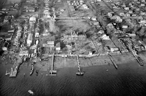 [Image: An aerial view of the Philadelphia Lazaretto, ca. 1929].
BLDGBLOG: Did that come with any constitutional issues, as to whether or not the Board of Health was violating the rights of the people it held in quarantine? How much of that sort of discourse was there at the time?
Barnes: There wasn’t much discourse about infringement of liberties, at least in the way we would see it today. However, the Board of Health was always politically controversial. There were controversies about the division of powers between the state and the city authorities, and there were always arguments about the extent of the Board of Health’s power.
Complaints by individual people who were enduring the unpleasant experience of quarantine usually did not take the form of complaints about their rights being violated. Rather, it was that they had other things to do. It’s boring; they need to be somewhere else; it’s interfering with their business; it’s interfering with their lives and it’s taking too long. Those sorts of more mundane, less philosophical complaints predominate.
On the other hand, there are constant complaints about the way that this authority was used—that the Board of Health was overdoing it, or overreaching, or interfering excessively with commerce. In fact, “interfering excessively with commerce” is the number one complaint I’ve found.
In any case, in 1799 the Board of Health chose and bought a new location on Tinicum Island, which is the site of the Lazaretto that I’m studying—the one that is still intact today. That site was roughly twelve to fourteen miles from the city proper. It was much more remote, and nobody lived nearby. The new Lazaretto they built there was a state-of-the-art facility—there was nothing like it anywhere else in North America and possibly even the world. They opened it in 1801, and it operated continuously until 1895.
Edible Geography: What does “state-of-the-art” mean for a Lazaretto at that time? What design rubric or template were they using?
Barnes: That’s a really good question. One of the main things was its size. It’s a ten-acre site, and the main building is huge. Today, it still looks like a very large, very stately building. It’s even, I would say, beautiful.
In terms of outbuildings, there was a separate two-story house for the Lazaretto physician, and another separate two-story home for the Quarantine Master. There were bargemen’s quarters and a watch-house right on the edge of the river. There was a United States Customs Facility right next door with a large warehouse for the storage of cargo undergoing quarantine. There were also smaller outbuildings like a kitchen and a barn, or carriage house.
Interestingly, the main gate to the Lazaretto site still survives—it’s a gorgeous, ornate, wrought-iron gate that’s a little bit overgrown with vines now. That was where all transactions with the outside world took place. You had to get written permission from the Board of Health before approaching the gate of the Lazaretto. In other words, all relatives and friends visiting those who were undergoing quarantine, or visiting those who lived and worked at the Lazaretto, had to get permission simply to approach the gate.
Then there was another hospital that was sometimes called the Dutch hospital, or the smallpox hospital. It was a fairly decent-sized, two-story building, built in 1804-5 on the northwestern corner of the property. It does not survive today.
Basically, it was a very expansive facility. It had the ability to house a large number of patients and to provide for the daily needs of the crew and passengers undergoing quarantine. I certainly don’t think it operated any differently, medically-speaking, from other hospitals or quarantine hospitals of the time. It was fairly well-staffed with full-time employees, at least during the quarantine season. The quarantine season varied. For most of the nineteenth century, the season was, by law, June 1st to October 1st—but the Board of Health could declare an early start or a late finish to quarantine. In really bad years, where there were lots of epidemics, or reports of epidemics, in various geographic regions, the quarantine season could last all year.
I think it’s really the size and extent—the staffing and capacity—of the Lazaretto that made it state-of-the-art at the time.
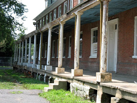 [Image: Photo by David Barnes].
BLDGBLOG: How exactly would one preserve the Lazaretto today—would you be preserving only the buildings themselves, or could you somehow preserve, even recreate, the experience of quarantine? Further, at what stage of its life would the Lazaretto be most usefully preserved—as it was built in 1801, or as it was closed down in 1895?
Barnes: All excellent questions. I’ll take your last one first.
The site did change over time, but it didn’t change all that much. The grounds certainly changed—gardens and ornamental hedges were planted. The most detailed surviving description of the site that I’ve been able to find is from a newspaper article in 1879. It’s a very, very detailed description of the buildings and grounds. We also have a gorgeous watercolor, but it’s undated; the best guess of the archivists and curators who have studied it is that it’s from the middle of the nineteenth century. That doesn’t tell us much, but you can make some educated guesses based on the way the people are dressed in it. We also do have some photographs from the 1880s and onwards.
Interestingly, the site and the buildings later went through several incarnations. It became the summer home of the Philadelphia Athletic Club—so it was a summer resort retreat for the wealthy elite of Philadelphia. The Philadelphia Athletics baseball team, which are today the Oakland A’s, played at the Lazaretto. They played on the northern half of the grounds. There are even some depictions of it laid out as a baseball field. Then, beginning around 1920, it was the first seaplane base in North America—an aviation training school for seaplane pilots. That’s what it was for most of the twentieth century.
As far as preservation goes, I can’t tell you how many hours I’ve spent thinking about this. My own fantasy is of a great historic site and museum. The site has unparalleled historical significance. Various people have called it Philadelphia’s Ellis Island—but, in some ways, I think it’s more significant than Ellis Island. Ellis Island has tremendous historical significance because of the volume of human cargo that passed through there. The sheer number of people who passed through Ellis Island is huge, as is the number of Americans today who can trace their ancestry back through the inspection station there. But Philadelphia’s Lazaretto is a century older—as well as completely different. It was the quintessential nineteenth century institution. To me, it’s a no-brainer that this would be a destination.
Having said that, it costs money to preserve and save historic sites. It costs a lot of money to restore the buildings and the grounds, and to maintain them. And museums, with a few exceptions, are not doing all that well; they don’t generally tend to pay their own way. It’s not a no-brainer financially, by any means.
The latest proposal I’ve heard is that the outbuildings could be dedicated to historical interpretation, and the main building itself would be dedicated to commercial office space. It’s all still up in the air.
 [Images: Out-buildings on the grounds of the Philadelphia Lazaretto, photographed by David Barnes].
Edible Geography: Your work suggests that quarantine is quite an overlooked dimension of everyday life in the early United States—as well as something of a forgotten chapter in the immigrant arrival experience. Why is that?
Barnes: Well, it was an unpleasant fact of life—that’s really the best way that I can put it. In one of the papers I’m writing about this, I call it “a most unloved institution.” Really, nobody liked quarantine at all. Merchants, of course, hated it—their cargo spoiled, time is money in business, and this was a huge delay, a waste of time, and an obstacle to commerce.
Everybody on board a ship couldn’t wait to get to their destination. Whether they were immigrants, as many of them were, or they were engaged in commerce—or simply visiting—everyone was desperate to arrive. They’re so close to getting there—but then they’re detained. They can write letters—but they can’t get off the ship unless they’re very sick and have to be taken to the hospital. Many refer to complete and utter boredom, and to impatience—sometimes to fear of getting sick. After all, you’re trapped on board a filthy ship with filthy people who have been confined together for weeks at a time. They are, in a sense, imprisoned on this vessel. All they can do is write letters and complain.
The paradox for me, historically, has been: how did quarantine survive so long, even into the twentieth century, when everybody hated it so much? Crews and captains hated it, passengers hated it, and doctors denounced it. Many doctors, throughout most of the nineteenth century, said quarantine was completely worthless, and that we should be devoting our attention to cleaning up our cities instead, because it was sanitation that would prevent epidemics. Other doctors didn’t go quite so far, but they did complain that quarantine was enforced arbitrarily and needlessly aggressively.
As to the experience of quarantine itself, I have only scattered bits of testimony. One of the letters I’ve found was from a Philadelphia-based merchant in 1804; I think his name was John Reynolds. I’ve found several letters that he wrote to his mother and sister in Philadelphia from the Lazaretto, where he was undergoing quarantine.
In each letter he says, “I hope to be liberated from here in a few more days.” And in the next letter, written five days later: “I cannot wait to escape from this place of my captivity.” He’s impatient. He’s not complaining that his rights have been violated; he’s just desperate to get out of there.
In one letter to his sister, he says, “It has been so long since I’ve been on shore. It has been so long since I have been home. I am dying to see some of those Pennsylvania beauties. You must introduce me to some as soon as I arrive.” This was in a letter to his sister.
It gets lonely where you’re trapped in this sort of sardine can!
Edible Geography: On average, how long were people held there?
Barnes: There is no general rule. The length of time varied from a day to two weeks, or even more. On occasion, vessels were detained for 30 days.
What’s interesting about the enforcement of quarantine is that there were three objects of detention: the vessel, the cargo, and the people on board. They were often treated very differently. I have lots of examples of vessels detained, and their cargo allowed to go on, but the people were kept on board. I have many other examples of the people being allowed to go, but the cargo being considered very dangerous and having to be cleansed and purified, usually by means of fumigation or with some kind of disinfectant spray.
Really, though, I think at the heart of quarantine is the idea of the cleansing power of time. The passage of time alone will make certain things better. If there is something dangerous in the vessel or in the cargo, it will declare itself within a period of time—or it will simply burn itself out. It can’t last indefinitely. Further, everybody knew from experience that things were fine after the first frost, so you would never detain any vessel, cargo, or people longer than the first frost.
 [Image: Painting of the Lazaretto attributed to T. Barnea (undated);
courtesy of the Atwater Kent Museum of Philadelphia].
[Image: Painting of the Lazaretto attributed to T. Barnea (undated);
courtesy of the Atwater Kent Museum of Philadelphia].
BLDGBLOG: There’s an interesting point to be made here vis-à-vis long-haul travel to extremely distant destinations. If a place took long enough to get to, in an era of wind-powered ships, quarantine wasn’t often necessary; any disease on board would already have burned itself out, as you say, by the time of arrival. But when steam-powered ships came along, and, then airplanes, people could arrive before a disease cycle came to its natural end—so quarantine stations became necessary. In other words, an entire class of architectural structures comes into existence because of the lengths of certain journeys or the types of transportation involved.
Barnes: That’s fascinating. Time is crucial in quarantine—and there is always a negotiation about how long is long enough. There was a tug of war, for instance, between the Lazaretto physician, who was the leading authority on the site, and the Board of Health, whose dictates that physician was required to obey. But you also had to factor in news reports of epidemics on various Caribbean islands, and you had to factor in the testimony of the captain and crew about what the health status of their port of origin—whether there were any illnesses there, what broke out during the journey, and if anyone had died. But is the captain reliable, or is he known to be a liar? And you also had to inspect the passengers and the crew physically. All of these were factors in the quarantine decision.
Time will always be a critical element of that calculus.
This autumn in New York City, Edible Geography and BLDGBLOG have teamed up to lead an 8-week design studio focusing on the spatial implications of quarantine; you can read more about it here. For our studio participants, we have been assembling a coursepack full of original content and interviews—but we decided that we should make this material available to everyone so that even those people who are not in New York City, and not enrolled in the quarantine studio, can follow along, offer commentary, and even be inspired to pursue projects of their own.
For other interviews in our quarantine series, check out Isolation or Quarantine: An Interview with Dr. Georges Benjamin, Extraordinary Engineering Controls: An Interview with Jonathan Richmond, The Last Town on Earth: An Interview with Thomas Mullen, and Biology at the Border: An Interview with Alison Bashford.
Many more interviews are forthcoming.
 [Image: Image 1, “Eternal Punishment,” from The Emperor’s Castle by
 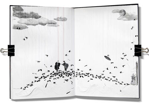 [Image: Image 2, “The Last Meeting,” from The Emperor’s Castle by
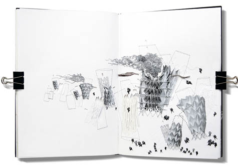
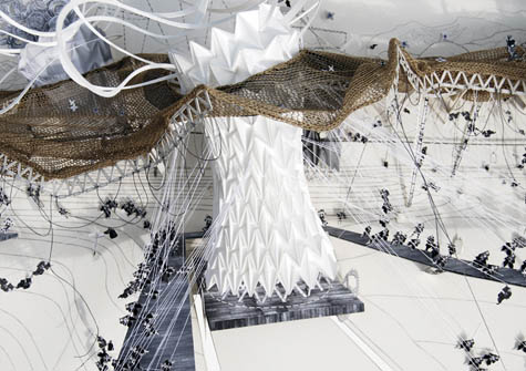
 [Images: Image 3, “The Emperor’s Origami Lungs”; Image 4, “The Princess’s Knitted Canopy”; and Image 5, “The Cowherd’s Mechanical Cow-cutters”; from The Emperor’s Castle by
  [Image: Image 6 from The Emperor’s Castle by

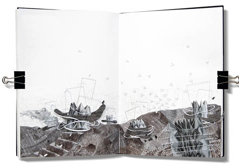
 [Images: Images 7, 8, 9, and 10 from The Emperor’s Castle by
  [Image: Image 11 from The Emperor’s Castle by

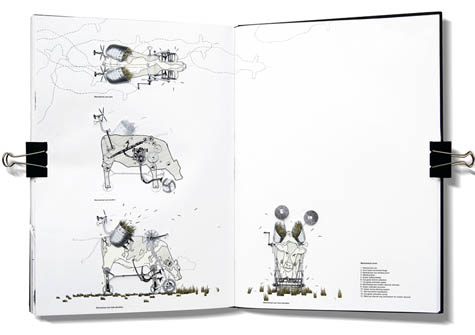
 [Images: Images 12, 13, 14, and 15 from The Emperor’s Castle by
  [Image: Photo by Vienna-based photographer
 [Images: Photos by

 [Images: By
  [Images: By
  [Images:
  [Images:
 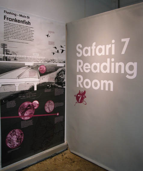 [Image: The
  [Images: Gavin Browning of
  [Image: A map of the 7 train’s ecological route; from the
  [Image: Let’s go on a city safari… From
  Vaguely similar things have been done, for instance, in London, where walking tours of the now-buried rivers beneath the city’s surface reveal what present-day geographies inhabit these lost natural worlds today. Of course, there is also Fritz Haeg’s
  [Image: Photo via the
  [Image: Thermal scanners at the Seoul international airport; photo by Jung Yeon-Je for Reuters, via
  [Image: Map of
 [Images: (top) The North Head Quarantine Station, Manly, Australia; photo by
  [Image: As Egypt and Sudan gained their independence from Britain, the border between the two countries was determined by drawing a straight line from the sea through
  [Images:
  [Image: An Italian Health Passport, via the
  [Image:
 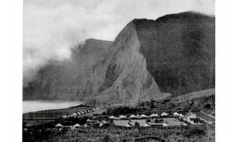 [Image: The
 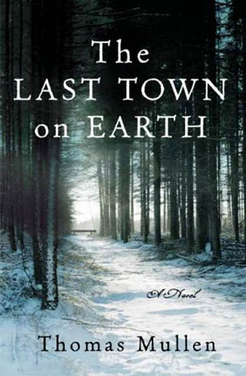 From the book’s description:
 [Image: Historical quarantine marker].
 [Images: The town of Jerome, Arizona, during the 1918 flu outbreak; note the face masks. Courtesy of the Jerome Historical Society, via the
  [Image: A sick ward for those infected with the
  Camus’s novel—about a quarantined city in North Africa called Oran, where the bubonic plague has erupted, originating in rats that have come crawling out into the streets to die en masse—seems to illustrate quite well the proposition that fiction is an extraordinarily effective medium through which to describe architectural and urban experiences. One of Camus’s characters, for instance, surveys the quarantined city laid out before him: “At that moment he had a preternaturally vivid awareness of the town stretched out below, a victim world secluded and apart, and of the groans of agony stifled in its darkness.”
 [Image: From
  [Image: From
  [Image: From
  [Image:
  [Images: Screen shots from
  [Image: Screen shot from
  [Image: The iPhone at work, detecting the
 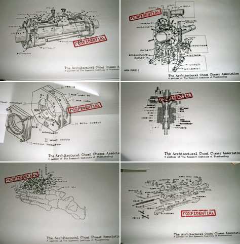 [Image: Patent diagrams for an “Architectural Ghost Chaser” by Sally Hsu;