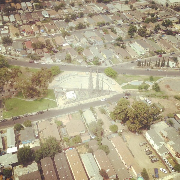
Panopticops

blade[Image: Flying with the LAPD Air Support Division; Instagram by BLDGBLOG].

Over the past three years, I’ve gone on multiple flights with the LAPD Air Support Division, during both the day and night; my goal was to understand how police see the city from above.

freeway-webside-web[Image: Freeways and escape routes; Instagrams by BLDGBLOG].

Does the aerial view afford new insights into how distant neighborhoods are connected, for example, or how criminals might attempt to hide—or flee—from police oversight? Where are these other, illicit routes and refuges?

More importantly, are they temporary accidents of criminal behavior and urban geography, or are they much deeper flaws and vulnerabilities hidden in the city’s very design?

above-webgotaltitude-web[Images: Instagrams by BLDGBLOG].

Aerial patrols seems to promise a ubiquitous, and near-omniscient, amplification of police vision, even as the fabric of the city itself is put to alternative use by the activities of criminals.

I documented these flights through hundreds of photographs—many of which can be seen here—as well as in my forthcoming book, A Burglar’s Guide to the City.

However, an excerpt of that book has also been adapted for this weekend’s New York Times Magazine, including a look at Thomas More’s Utopia in the context of the LAPD, the navigational “rules of four,” and a look at the array of technical devices installed aboard each police helicopter.

screen-webdashboard-web[Images: Inside the airship; Instagrams by BLDGBLOG].

The “rules of four,” for example, as I write in the piece, are “guidelines [that] fall somewhere between a rule of thumb and an algorithm, and they allow for nearly instantaneous yet accurate aerial navigation.”

“The way the parcels work in the city of Los Angeles,” [LAPD Chief Tactical Flight Officer Cole Burdette explained to me], “is that Main Street and First Street are the hub of the city.” The street numbers radiate outward — by quadrant, east, west, north, south — with blocks advancing by hundreds (the 3800 block below 38th Street) and building numbers advancing by fours (3804, 3808, 3812, etc.). The rest is arithmetic.
(…)
With the rules of four, an otherwise intimidating and uncontrollable knot of streets takes on newfound clarity. It is no coincidence that the Los Angeles Police Department built its main headquarters at the center of it all, at the intersection of First and Main. It placed the department at the numerological heart of the metropolis, the zero point from which everything else emanates.

What fascinates me through all of this is how the city can be used as a tool of police authority, a seemingly endless crystalline grid of numbers and addresses continually re-scanned from above by helicopter—

binocs-webbinoculars-webshoulder-web[Image: Watchers; photo by BLDGBLOG].

—yet, at the same time, the city can also be manipulated from below, against those same figures of aerial power, becoming an instrument of criminal evasion and spatial camouflage.

matrix-web[Image: Night flight across the grid; Instagram by BLDGBLOG].

The very notion of the “getaway route” is revealing here for what it implies about a city’s secondary use as a means of escape, offering hidden lines of flight from figures of authority.

In the book, I explore this a bit more through, among other things, the work of Grégoire Chamayou, including his research into the history of manhunts and his brief look at the speculative re-design of Paris as a kind of immersive police catalog in which “every move will be recorded.”
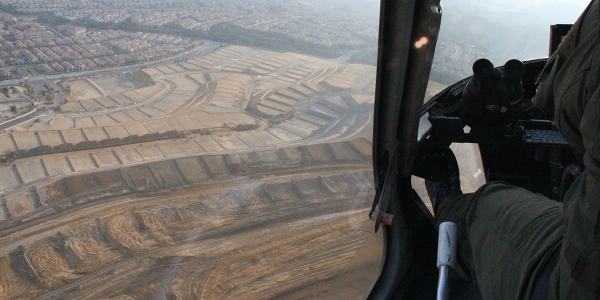
subdivision-websuburbs-web[Image: Over Porter Ranch and the San Fernando Valley; photos by BLDGBLOG].

Paris, Chamayou writes, “was to be divided into distinct districts, each receiving a letter, and each being subdivided into smaller sub-districts.”

In each sub-district each street had accordingly to receive a specific name. On each street, each house had to receive a number, engraved on the front house—which was not the case at the time. Each floor of each building was also to have a number engraved on the wall. On each floor, each door should be identified with a letter. Every horse car should also bear a number plate. In short, the whole city was to be reorganized according to the principles of a rationalized addressing system.

In that context, the Air Support Division’s “rules of four” as a police-navigation strategy take on a particularly interesting nuance—as do hypothetical means of resistance to police power through the deliberate complication of local addressing systems.

mapping-webbanking-webpanopticops-web[Images: Moving maps and binoculars over L.A.; Instagrams by BLDGBLOG].

The book excerpt in the Times also briefly picks up on some themes elaborated in an article I wrote for Cabinet Magazine a few years ago, discussing how the infrastructure of Los Angeles itself inadvertently permits certain classes of criminal activity.

turning-web[Image: Night flying; photo by BLDGBLOG].

The most obvious example of this unintended side-effect of transportation planning is the so-called “stop-and-rob.” From The New York Times Magazine:

The construction of the city’s freeway system in the 1960s helped to instigate a later spike in bank-crime activity by offering easy getaways from financial institutions constructed at the confluence of on-ramps and offramps. This is a convenient location for busy commuters—but also for prospective bandits, who can pull off the freeway, rob a bank and get back on the freeway practically before the police have been alerted. The maneuver became so common in the 1990s that the Los Angeles police have a name for it: a “stop-and-rob.”

In any case, the book obviously elaborates on these themes in much greater length—and it comes out next week, so please consider pre-ordering a copy—but The New York Times Magazine excerpt is a great place to start.

points-web[Image: Somewhere over the San Fernando Valley; Instagram by BLDGBLOG].

Meanwhile, if you yourself are planning any illicit activities, as an added bonus the article includes insights from Air Support Division pilots and tactical flight officers on the limitations of their own surveillance techniques, such as how the streets around Los Angeles International Airport have become a popular hiding spot for criminals fleeing police helicopters by car and some especially unlikely tactics used to evade thermal detection by the LAPD’s Forward-Looking Infrared or FLIR cameras.

When in doubt—although this is not mentioned in the article—drive into the fog, where the helicopters can’t follow you.

horizon-web[Image: Urban horizon lines; Instagram by BLDGBLOG].

For now, here are a bunch of photos, including many Instagrams, taken from July 2013 to March 2016, including night flights in January 2014 and March 2016—

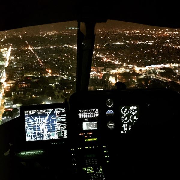
cockpit-webflying-webhollywood-webmorecityhall-webnighflight-webtennis-webbanktower-webusbank-webnickersonnight-webspot-web[Images: Night from above; photos & Instagrams by BLDGBLOG].

—as well as day and early evening flights taken in July 2013 and March 2016.

nickerson-webwattstowers-webgrid-webplane-web[Images: Note the shot of Watts Towers; Instagrams by BLDGBLOG].

Finally, a chunk of non-Instagram shots, in case those colored filters are making your eyes cross over.
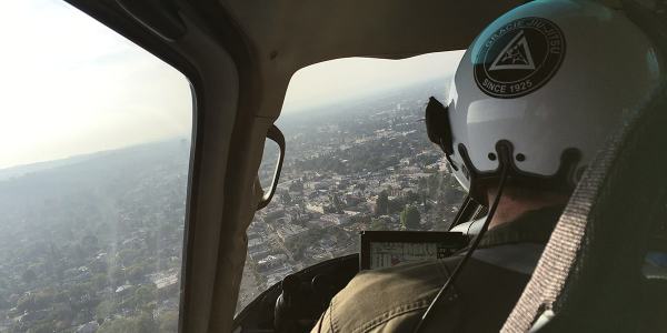
jiujitsu-webcops-webgunsdrawn-webtfo-webLAKings-weblooking-web[Images: Photos by BLDGBLOG, many featuring a home barricade call in Pacoima].

Check out the article—and let me know what you think of the book, once it’s published.

sunset-web[Image: Sunset approaching downtown L.A.; cropped Instagram by BLDGBLOG].

“Sometimes the house you come out of isn’t the same one you went into”

CeL5zQKWwAAIyl8.jpg-large[Images: From @strangethink23].

The recently erased and rebooted Twitter account for Strangethink@strangethink23—has been posting some really interesting images and GIFs over the past three weeks, exploring the procedural generation of architectural interiors.

The most recent theme/obsession seems to be the difficulty—and perverse joy—of adding staircases between levels in an “infinite non-euclidean house,” in their words, or an architecture of “infinitely generated nesting structures.”

The results are ostensibly only relevant if you’re a game developer, but they’re actually well worth scrolling through anyway, as they’re also part koan, part Borgesian fever-dream. The images and related tweets discuss things like “a bug where ghostly shells of floors can be left over from previous generations,” or the idea that “every inside is a new outside.”

CeQz1C0WAAEb15C.jpg-large[Images: From @strangethink23].

Sometimes the house you come out of isn’t the same one you went into. It’s okay though,” we read. Or: “Each generated house contains up to 8 other houses and each of those contains up to 8 houses and each of those…” “What’s inside that building? MORE BUILDINGS.”

Indeed, there is a running sub-theme of “big buildings inside small buildings,” hidden infinities tucked away behind the next doorframe or at the bottom of the next soon-to-appear stair.

My interest here is less in the actual aesthetics of the buildings—with their technicolor cantilevers and their relentlessly rectilinear rooms and balconies—but more in the sheer poetics of procedural generation itself: the dreamlike rules and subroutines of rooms triggering other rooms, of algorithms lying in wait before stuttering out a new, far bigger building inside the building you’re already in.

Check it all out now, before their Twitter feed is erased and restarted once again.

(Via @jimrossignol. Earlier on BLDGBLOG: Procedural Brutalism and British Countryside Generator).

A Burglar’s Guide to the City

burglars
For the past several years, I’ve been writing a book about the relationship between burglary and architecture. Burglary, as it happens, requires architecture: it is a spatial crime. Without buildings, burglary, in its current legal form, could not exist. Committing it requires an inside and an outside; it’s impossible without boundaries, thresholds, windows, and walls. In fact, one needn’t steal anything at all to be a burglar. In a sense, as a crime, it is part of the built environment; the design of any structure always implies a way to break into it.

You can see burglary’s architectural connections anywhere. Watch nearly any heist film, for example, and at some point there will be an architectural discussion: inevitably, the characters will point at floor plans or lean in close to study maps, arguing over how to get from one room to another, whether or not two buildings might actually be connected, or how otherwise separate spaces and structures—sometimes whole neighborhoods—might be secretly knit together. Seen this way, heists are the most architectural genre of all.

BurglarEntersHouse[Image: “How The Burglar Gets Into Your House” (1903), via The Saint Paul Globe].

When a burglary is committed in the real world, you often see stunned business owners stammering to morning TV crews about how strange the burglars’ method of entry was. They came in through the walls or jumped down through a hole in the ceiling—or crawled in through a drop-off chute—rather than going through the front door as the rest of us would, never using buildings the way they’re supposed to be used.

This notion—that burglary, at heart, is an architectural crime—serves as the core of my new book. It comes out in less than a month, on April 5th, from FSG. It’s called A Burglar’s Guide to the City.

I’m strangely thrilled to see it’s been categorized as “Architecture/True Crime.”

Burglars-FinalCover[Image: The complete front/back cover for A Burglar’s Guide to the City, designed by Nayon Cho].

Researching A Burglar’s Guide to the City has been a fascinating process—not to mention an incredible experience. It took me up into the sky over Los Angeles with the LAPD Air Support Division to learn how police see the city, out to visit a lock-picking group in northwest Chicago to pop open some padlocks and understand the limitations of physical security, and into the heavily fortified modular “panic rooms” designed by a retired New Jersey cop.

I spoke with a Toronto burglar who learned to use his city’s fire code as a targeting mechanism for future burglaries; I talked to the woman who arrested a kind of live-in burglar nicknamed “Roofman” who, incredibly, built a fake apartment for himself inside the walls of a Toys “R” Us; and I met the retired FBI Special Agent once tasked with tracking down a crew of subterranean bank bandits who pulled off a still-unsolved bank heist in 1986 Los Angeles, involving weeks of tunneling and a detailed knowledge of the the city’s sewer system. I spoke with one of the originators of the UK’s surreal “capture house” program, where entire fake apartments are kitted out and run by the police to trap—or capture—specific burglars, and I even visited the grave of a 19th-century super-burglar who used his training as an architect to lead a crew responsible for an astonishing 80% of all U.S. bank robberies at the time.

lapd[Image: Flying with the LAPD Air Support Division; Instagram by BLDGBLOG].

The book includes tunnel jobs from ancient Rome, a survey of door-breaching tools, an interview with architect Bernard Tschumi about crime and the city, some thoughts on Die Hard, even tips for the ultimate getaway from a reformed bank robber in California, and on and on and on.

In any case, I’m genuinely excited for the Burglar’s Guide to be out in the world. I can’t wait to discuss it with readers, so please check it out if you get a chance.

Meanwhile, there will be a short book tour this April and May. Keep an eye on burglarsguide.com for more information as it develops, but, for the time being, if you’re anywhere near New York, Boston, Chicago, Los Angeles, San Francisco, Portland, Seattle, or Washington D.C., save the dates to come by and say hello.

Mossman_Invite_B_Web

The first event will be hosted by the incredible John M. Mossman Lock Collection at the General Society of Mechanics and Tradesmen of the City of New York on Tuesday, April 5, with beer provided by my friends at Sixpoint Brewery and books for sale courtesy of The Strand Book Store. Even better, Radiolab’s Robert Krulwich will be leading a live conversation about the book—and the event itself is free, although you must RSVP.

I could go on at great length—and undoubtedly will, in the weeks to come—but, for now, consider pre-ordering a copy of the book. Thanks!

Mars Monuments and “First Landing Sites”

mars[Image: An incredible shot of Mt. Sharp on Mars, via NASA].

Science writer Lee Billings has an interesting new article up at Scientific American about the quest to identify future landing sites on Mars.

Having recently attended an event in Houston dedicated to the topic of how humans might colonize the Red Planet—and, more specifically, where exactly they will land—Billings describes scenes that seem to resemble a tabletop role-playing game crossed with a good old-fashioned land grab:

In the sunlit rotunda outside the Lunar and Planetary Institute’s auditorium they had placed permanent markers and two glossy, oversize maps of Mars on foldout tables. Each participant autographed the maps, as if a delegate signing an interplanetary Declaration of Independence, usually marking the site where he or she hoped humans would go first. Before long both maps accumulated thick clusters of signatures marking 45 potential “Exploration Zones,” or EZs. Each EZ was a circle 200 kilometers wide, equaling an area nearly 20 times larger than the sprawling city of Houston.

These “Exploration Zones” marked target sites of potential human settlement and exploration—as well as, by implication, others places where humans might never go at all. “Among the signatures scattered on the map,” Billings writes, “there were voids conspicuously light on scrawls—places where no human would tread anytime soon, if ever.”

aramchaos[Image: A Martian basin called “Aram Chaos,” NASA/JPL-Caltech/Arizona State University; via Scientific American].

While this has the potential to remain entirely abstract—determining where humans may or may not someday settle on a world they may or may not ever even visit—there are some moments of evocative specificity.

Those include one participant’s vision of future human geologists chipping and scraping away at the walls of a colossal Martian landform called Valles Marineris, revealing “interior layer deposits, ancient bedrock, ancient lake deposits, sand dunes, landslides,” and uncovering traces of what Billings calls “a former, warmer, wetter world, and perhaps even learn[ing] whether anything had ever lived there.”

In any case, there are volcanologists and robots, “exotic locales” and bombs for mining ice, the ethical question of “Planetary Protection” and the limits of terrestrial law; it’s a fascinating look at conversations occurring today that might yet prove to be of great geographic significance for having determined, decades in advance, which landscapes will someday become intensely familiar to human settlers, on a planet that, for now, remains seemingly just out of reach.

Briefly, I’m also reminded of a paper presented a number of years back by Australian student Trevor Rodwell, called “Messages for the Future: The Concept for a First Human Landing Marker on Mars.” Although I don’t actually agree with Rodwell’s approach—he more or less outlines a digital time capsule that would remind future Martian settlers of Earthly life—I nonetheless find his idea of a “First Human Landing Monument” incredibly interesting, and suitably grandiose in terms of the workshop Billings documents.

How should we—if at all—mark a site that functions as a kind of interplanetary Plymouth Rock, and, in retrospect, how will conversations such as the ones Billings writes about be seen by future settlers?

Perhaps another way to put this is that we are already building an archive for the prehistory of humans on Mars, even if their departure for that planet has yet to occur.

_applyChinaLocationShift

shanghaishift[Image: The same point in Shanghai, shifted between its map and satellite view; via Google Maps].

The slippage between map and territory is made unsettlingly clear by a mandatory geographic offset introduced into digital cartography products operating in China.

Variously known as “_applyChinaLocationShift,” eviltransform, the “China GPS Offset Problem,” and, most interestingly, as “Mars Coordinates,” this algorithmic shifting of GPS coordinates is related to China’s official mapping and survey rules, devised for national and economic security.

I’ve written much more about this in a new article for Travel + Leisure, where everything from trap streets to Jorge Luis Borges gets involved, as well as questions of technology, international borders, and geopolitics. Check it out, and let me know if you’ve had any experience with the issue yourself.

(Thanks to @0xdeadbabe for the tip!)