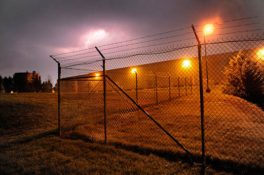
 [Image: The “buried cable intrusion detection sensor,” courtesy of G-Max Security].
1) The Israeli-based company G-Max Security makes a “buried cable intrusion detection sensor” that is “totally concealed and operates effectively under any type of surface,” from open fields and highways to mountains, snow, and ice. It acts as a “perimeter detection ring” that uses “Passive Magnetic Detection” technology—that is, a buried cable-sensor network—assuring “effective Early Warning of any perimeter intrusion attempt.”
This security geotextile is, in effect, an electromagnetic nervous system in the ground.
 [Image: The sensor after burial, courtesy of G-Max Security].
However, the system perhaps also foreshadows the implementation of much more complex, spatially ubiquitous, and locally intelligent geotextiles that could monitor, from below, in real-time, and with remarkable accuracy, everything that passes through the landscapes above them.
The most secure landscape in the world could thus someday be an open field—or friendly suburb—peppered with trees and flowers in which all of the surveillance technology is passive, omniscient, experientially invisible, and indistinguishable from the earth.
As a useful replacement for land mines and electrified fences, however, the very idea of a security geotextile brings an alarming potential for weaponization. For instance, what would stop such a system from being given the ability to electrify, stun, immobilize, or even kill a detected intruder? Perhaps this would be the malign or malevolent geotextile I ask about in my essay for Philip Beesley’s recent book, Hylozoic Ground.
Either way, it will be interesting—and unfortunately necessary—to track the potentially emergent field of weaponized geotextiles.
2a) The Dutch engineering firm TenCate offers a product called the GeoDetect system. It is “the first sensor enabled geotextile on the market to provide soil reinforcement, structural health monitoring and an early warning system into one package.”
It is a computational fabric that structurally strengthens and physically monitors the landscapes it is buried within.
“Our ‘intelligent geotextile,'” the company points out, “is the first system designed specifically for geotechnical applications and offers a technical solution for monitoring geo-structures for changes in strain, temperature or the combination of the two.” As such, it “incorporates a geocomposite fabric, fiber optics, instrumentation equipment and software to provide a innovative solution for the multi-functional requirements of a geotechnical application” (for example, stabilizing landfills and levees).
You can watch a short video about it here.
2b) To speculate a bit here, if TenCate’s GeoDetect is basically a 2D computer or sensor network, then, given further processing power and mechanically augmented with servomotors, a future version of this system could perhaps not only engage in locally autonomous decision-making—a kind of 2D supercomputer disguised as a landscape—but could also physically rearrange itself to protect against impending disasters (such as levee failure or an avalanche).
We might thus find that sentient artificial landforms built from networks of computational geotextiles and mobilized from within by servomotors could literally redesign landscapes in place, on their own, at will. This would, presumably, be for practical purposes (flood mitigation or landslide control), but could also be purely for aesthetics. Imagine a new park of crawling landforms—slow ripples moving through the grass, forming constantly refreshed hills and valleys, the soil pulsing in waves.
 [Image: A photo by Toshio Shibata].
These speculative geotextiles, otherwise invisible beneath the ground, could use their own algorithms to monitor visitor activity and thus compute the appropriate spatial response to those visitors’ location in the park.
Given such a scenario, the entire Dutch coast could someday be, we might say, a robot: a self-intelligent system of interacting mechanical fabrics that rearrange on their own volition, on the scale of hundreds of miles, to keep Atlantic floodwaters at bay. The art of landscape photography is revolutionized. Bewildering art films are set amongst this crawling landscape. Slow hills move and dance in front of the sun.
 [Image: An otherwise unrelated photo of concrete block installation atop a geotextile base, courtesy of the Directorate of Public Works, Ft. Jackson, South Carolina].
3) These technologies could, of course, be networked yet further, off-site, to other unmanned and interactive technologies. We might describe this as a semi-autonomous landscape-to-robot constellation.
In other words, a sensor-embedded stretch of earth—using a radio-transmitting variant of G-Max’s buried cables—could communicate directly with unmanned aerial vehicles, steering them in for precise landings. It is a kind of invisible runway. Or long strips of buried sensors on the perimeter of secure sites could guide UAVs flying high above; pilotless machines bank and turn in a constant loop, following the geotextiles below. They are locked in place—they are steered and guided—by transmissions from inside the ground. (The same could be true of unmanned ground vehicles, following otherwise invisible electromagnetic “roads” embedded in the soil.)
 [Images: “An MQ-9 Reaper remotely piloted aircraft takes off July 17 from Joint Base Balad, Iraq. The Reaper can loiter over battlefields or targets for hours at a time without refueling and carries up to 3,750 pounds of laser-guided munitions, giving ground commanders unprecedented situational awareness and the ability to bring the right amount of force to bear on a target. (U.S. Air Force photo/Tech. Sgt. Richard Lisum)”].
In effect, this would terrestrialize the so-called robot-readable world: burying the signs and sensors that such machines require and disguising them in apparently natural circumstances. What appears to be a meadow is actually an electromagnetically active runway read and used by UAVs. What you think is a forest is a complex signaling landscape. What appears to be a garden is a computational geotextile interacting with driverless ground vehicles miles away.
4) In any case, all of the above ideas could, perhaps much more interestingly, be used to activate a kind of anti-drone defensive landscape. As the horrific possibility of drone proliferation looms, what spatial and geographic countermeasures could be implemented to mislead, confuse, detour (or détourn), and otherwise deflect pilotless vehicles?
The “perimeter detection ring” examined above, for instance, would instead be used to repel or otherwise blind “intruding” UAVs and UGVs; this could be used for everything from keeping a foreign power’s drones out of your sovereign airspace to preventing the IRS from flying drones over your suburb for property tax purposes.
In mythological terms, this would be the geotextile as talisman, or terrestrial ring of protection.
 [Images: Geotextiles, courtesy of the U.S. Federal Highway Administration].
So what possibilities exist for landscape architects to, as it were, resist drones, using signal-jamming geotextiles, electromagnetic dazzle effects, or even bizarre new forms of robot-readable camouflage, in order to make drone warfare all but spatially impossible?
Could anti-drone landscapes be added to existing cities—urban spaces or architectural forms lethally confusing to robots—and what might such additions actually look like (if they would be visible to humans at all)?
(Thanks to Rob Holmes and Brett Milligan for first alerting me to the GeoDetect system).

 [Image: Breaking Out and Breaking In poster by
  [Image: Breaking Out and Breaking In poster by
 [Image: The expansion of Manhattan island, via
 [Image: “

 [Images: “
 [Images: “
 [Images: “

 [Images: “
 [Images: “
 [Images: “
 [Image: New York Harbor, mapped in 1966, courtesy of
  [Image: New York Harbor, mapped in 1957, courtesy of
  [Image: From the
 [Image: The “buried cable intrusion detection sensor,” courtesy of
  [Image: The sensor after burial, courtesy of
  [Image: A photo by
  [Image: An otherwise unrelated photo of concrete block installation atop a geotextile base, courtesy of the
  [Images: “An MQ-9 Reaper remotely piloted aircraft takes off July 17 from Joint Base Balad, Iraq. The Reaper can loiter over battlefields or targets for hours at a time without refueling and carries up to 3,750 pounds of laser-guided munitions, giving ground commanders unprecedented situational awareness and the ability to bring the right amount of force to bear on a target. (
 [Images: Geotextiles, courtesy of the U.S.
 [Image: An otherwise unrelated photo of electric cables being installed in the Golden Gate Bridge, October 1935; courtesy of the
 [Image: Photo by
 [Image: From “Baffles and Bastions: The Universal Features of Fortifications” by Lawrence H. Keeley, Marisa Fontana, and Russell Quick, courtesy of the