The town at risk from cave-ins

In what sounds like the plot of a bad horror film, we read that “kids in Picher, Okla., are exposed to lead, and the ground is at risk of cave-ins” due to the “abandoned mines beneath the city.”

Turns out the whole town is now under “voluntary buyout” by the US government because the place is so polluted that no one should be living there. Tailings from abandoned lead and zinc mines are to blame; indeed, there are “giant gray piles of mining waste, known locally as ‘chat,’ some hundreds of feet tall and acres wide, that loom over abandoned storefronts and empty lots.”

[Image: “Chat piles” looming round the “abandoned storefronts and empty lots” of Picher, OK; photo by Matt Wright, author of the article I’ve been quoting. See also this photo gallery from the US Geological Survey’s own tour of Picher, or this series of images from 1919].

From the Washington Post:

Signs of Picher’s impending death are everywhere. Many stores along Highway 69, the town’s main street, are empty, their windows coated with a layer of grime, virtually concealing the abandoned merchandise still on display. Trucks traveling along the highway are diverted around Picher for fear that the hollowed-out mines under the town would cause the streets to collapse under the weight of big rigs. (!) In some neighborhoods, empty mobile homes sit rusting in the sun, their windows broken, their doors yawning open, the detritus of life—car parts, broken toys, pieces of carpet, rotting sofas—strewn across their front yards.

But what happens in twenty years’ time, when a group of joy-riding teenagers from across state lines find themselves driving through Picher in the late afternoon…? They park their car, laughing, and throw rocks through some windows; one of them sneaks behind the old neighborhood Piggly Wiggly and opens up the door of a small shed only to find the entrance to a mine—when, suddenly, the ground opens up on the main street and swallows all three of his friends.

He hears screaming—as well as what sound like whispering voices coming from beneath the ground. The sun setting, our naive hero of the high school football squad descends into the lead mines to find them…

Or has that film already been made?

(Thanks, Javier! See also Helltown USA and Cancer Villages).

The Planet Miller

[Image: The “Voronoi Shelf” and “Extruded Chair” by Marc Newsom; image by Lamay Photo, courtesy of Gagosian Gallery, NYC].

In a recent post on gravestmor we read about the furniture of Marc Newsom. Every table, chair, and bookshelf Newsom designs has been individually milled “from a single slab of marble from the same Carrara quarry” – so there are no hinges and no joinery.

[Image: A “lathed marble table” by Marc Newsom; image by Lamay Photo, courtesy of Gagosian Gallery, NYC].

“I think that if this proves anything,” Marcus at gravestmor writes, “it is that it is clear now that it was a mistake to build the Beijing Olympic Stadium in steel” – after all, he says, “carving the whole thing out a single piece of marble would have, in hindsight, been the correct choice.”

[Images: Two “extruded” tables by Marc Newsom; image by Lamay Photo, courtesy of Gagosian Gallery, NYC].

Alternatively, you could take several dozen CNC-milling machines – like the ones that Newsom used – and disappear into the Rocky Mountains. Alone.
Over the course of a decade, you mill every single peak in northwestern Colorado into an elaborate cobweb of arches and shelves, weird nets of rock that stand thousands of feet above the horizon. You mill gentle slides and curves, nesting one into the other across counties – huge, gyroscopic spans bending down through the mountain air. Then, a few miles away, you begin work on a new town that no one else knows about, complete with churches, homes, and a small planetarium, ground and polished straight from the exposed surface of the earth. On quiet nights, the wind hums across doorsills…
Everyday, fifty years from now, at sunset, in a village called Lumière, a new kind of cinema begins: huge, moving shadows creep across the landscape, dragging east against the falling of the sun. Golden light casts like a laser through complex shapes milled decades earlier.
People sit in lawn chairs, watching, stunned.

(Vaguely related: On the geotechnical invasion of paradise and Milled landscapes – though that second link is pretty old).

Tresor

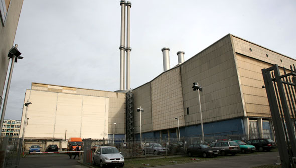
According to a short article in The Berlin Paper, “legendary” Berlin nightclub Tresor is set to reopen “in an old steam-heat generating plant” on Köpenicker Straße.

[Image: Tresor’s new home; photo by Thilo Rückeis for Der Tagesspiegel, via The Berlin Paper].

Tresor’s original founder, Dimitri Hegemann, “wants to promote electronic music and electronic art” in the new space. Indeed, Hegemann “envisions hosting pieces similar in style to Olafur Eliasson’s Weather Project at the Tate Modern.”
The new location “boasts four levels, 20,000 square meters of space (215,278 square feet), and 30 meter ceilings (98 feet). It lends itself to the kind of third art space between the Nationalgalerie and Hamburger Bahnhof that many in Berlin, including mayor Klaus Wowereit, have been calling for.”
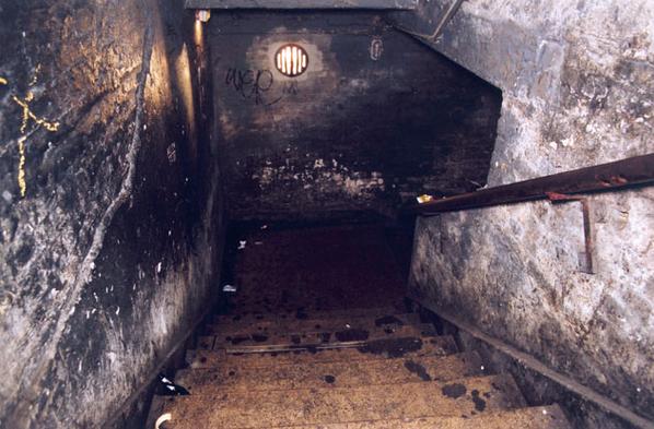
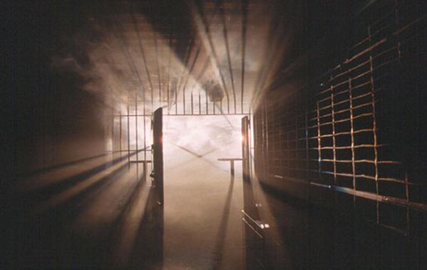
A quick note on the original Tresor: it opened in 1991 in the vault of the old Wertheim department store, near Potsdamer Platz, on what would have been the east side of the Wall. There was an upstairs space, called Globus, for house music, and this insane basement – the actual Tresor – where low ceilings, hundreds of people, ridiculously loud music, and smoke so thick you sometimes couldn’t see your own hand in front of your face made it feel like some sort of serial killer UFO-dungeon loose beneath the streets of the city.

[Images: The staircase down, and the dancefloor it led to; photos courtesy of Tresor].

As Tresor’s own website describes it: “the club’s rough, apocalyptic atmosphere ruled above all: condensation dripped down the raw concrete walls of the old vault rooms; rusty steel bars separated visitors from the bar; several hundred forced-opened safe-deposit boxes lined the walls that spoke of wealth long forgotten; strobe lights and fast, hard beats dominated the dance floor. Only here could electronic music correspond with such architecture – the senses were left equally numbed and brutalised.” And I was there almost every Wednesday and Friday night for two summers in a row. Going deaf.
Meanwhile, the new space could be open to the public as early as March 16th, 2007. Anyone want to fly me to Berlin…?

[Image: Humans beneath the surface of the earth, listening to music; photo courtesy of Tresor].

(News spotted via Artkrush. Note: you can listen to old sets from Tresor via this link).

Geology in the Age of the War on Terror

A few months after September 11th, the New York Times published a kind of geological look at the War on Terror.
In a short but amazingly interesting – albeit subscriber-only – article, the NYTimes explored how ancient landscape processes and tectonic events had formed the interconnected mountain caves in which Osama bin Laden was, at that time, hiding.

[Image: The topography of Afghanistan, a sign of deeper tectonics. In a cave somewhere amidst those fractal canyons sat Osama bin Laden, in the darkness, rubbing his grenades, complaining about women, Jews, and homosexuals…].

“The area that is now Afghanistan started to take shape hundreds of millions of years ago,” the article explains, “when gigantic rocks, propelled by the immense geological forces that continuously rearrange the earth’s landforms, slammed into the landmass that is now Asia.”
From here, rocks “deep inside the earth” were “heated to thousands of degrees and crushed under tremendous pressures”; this caused them to “flow like taffy.” And I love this next sentence: “Just like the air masses in thunderstorms, the warmer rocks rise and the cooler ones sink, setting up Ferris wheel-shaped circulations of magma that drag along the crust above them. Over time, these forces broke off several pieces off the southern supercontinent of Gondwanaland – the ancient conglomeration of South America and Africa – and carried them north toward Asia.”
Of course, Afghanistan – like most (but not all) of the earth’s surface – was once entirely underwater. There, beneath the warm waves of the Tethys Seaway, over millions of year, aquatic organisms “were compressed into limestone.”
Limestone, incidentally, is less a rock than a kind of strange anatomical by-product – something the living can become.
In any case, these massive and shuddering tectonic mutations continued:

Minerals from the ocean floor, melted by the heat of the interior, then flowed back up near the surface, forming rich deposits of copper and iron (minerals that could someday finance an economic boom in Afghanistan). The limestone along the coasts of Asia and India buckled upward, like two cars in a head-on collision. Water then ate away at the limestone to form the caves. Though arid today, Afghanistan was once warm and wet. Carbon dioxide from decaying plants dissolves into water to form carbonic acid, and in water-saturated underground areas, the acid hollowed out the limestone to form the caves, some several miles long.

The story gets really interesting here, then; think of it as the CIA-meets-geology.

[Image: Via the Telegraph].

What happened was that Osama bin Laden, in hiding after 9/11, started releasing his famous videotapes – but those tapes included glimpses of cave walls and rocky hillsides behind him.
When John F. Shroder – a geologist specializing in the structure of Himalayan Afghanistan – saw the tapes, he tried to interpret their setting and background, looking for mineralogical clues as to where bin Laden might be. Like a scene from The Conversation – or, hermeneutics gone geo-cinematic – Shroder pored over the tapes, fast-forwarding and rewinding, scanning for subtle signs…
It was the surface of the earth on TiVo.
“Afghanistan’s fighters find shelter in the natural caves,” the New York Times continues. “They also make their own, often in the mountains of crystalline rock made of minerals like quartz and feldspar, the pieces of Afghanistan that were carried in by plate tectonics. ‘This kind of rock is extremely resistant,’ Dr. Shroder said. ‘It’s a good place to build bunkers, and bin Laden knows that.’ Dr. Shroder said he believed that Mr. bin Laden’s video in October was taken in a region with crystalline rocks like those south of Jalalabad.”
All of which makes me think that soldiers heading off to Afghanistan could do worse than to carry bulletproof copies of Jules Verne’s Journey to the Center of the Earth along with them.
As another New York Times article puts it: “Afghanistan is a virtual ant farm of thousands of caves, countless miles of tunnels, deeply dug-in bases and heavily fortified bunkers. They are the product of a confluence of ancient history, climate, geology, Mr. bin Laden’s own engineering background – and, 15 years back, a hefty dose of American money from the Central Intelligence Agency.”
Bin Laden et al could thus “take their most secret and dangerous operations to earth,” hidden beneath the veil of geology.

(Elsewhere: Bryan Finoki takes a tour of borders, tunnels, and other Orwellian wormholes; see also BLDGBLOG’s look at Terrestrial weaponization).

The Architecture of Managed Retreat

For some reason, BLDGBLOG’s recent look at architectural partitioning reminded me of something from The Rings of Saturn by W.G. Sebald.
At one point, Sebald is describing the slow collapse of large manor houses as they fail to survive years of inadequate maintenance:

Keeping up the houses even in the most rudimentary way had long been impossible. The paintwork was flaking off the window encasements and the doors; the curtains became threadbare; the wallpaper peeled off the walls; the upholstery was worn out; it was raining in everywhere, and people put out tin tubs, bowls and pots to catch the water. Soon they were obliged to abandon the rooms on the upper storeys, or even whole wings, and retreat to more or less usable quarters on the ground floor. The window panes in the locked-up rooms misted over with cobwebs, dry rot advanced, vermin bore the spores of mould to every nook and cranny, and monstrous brownish-purple and black fungal growths appeared on the walls and ceilings, often the size of an ox-head. The floorboards began to give, the beams of the ceilings sagged, and the panelling and staircases, long since rotten within, crumbled to sulphurous yellow dust, at times overnight. Every so often, usually after a long period of rain or extended droughts or indeed after any change in the weather, a sudden, disastrous collapse would occur in the midst of the encroaching decay that went almost unnoticed, and had assumed the character of normality. Just as people supposed they could hold a particular line, some dramatic and unanticipated deterioration would compel them to evacuate further areas, till they really had no way out and found themselves forced to the last post, prisoners in their own homes.

(More Sebald: The birds and Bunker Archaeology).

Urban strangeness

This happens all the time to other blogs, who are constantly popping up in things like BusinessWeek and Metropolis and Dwell – and so it’s more or less a kind of meaningless chest-thumping to point this out – but I was quite excited to see that BLDGBLOG (under its nom de guerre of BLDG) was listed in this Saturday’s copy of The Guardian

– along with design*sponge and The Cool Hunter
Anyway, blah blah blah. I was just excited to see that. Sorry.

(Thanks to John Coulthart for the tip!)

The wall

In New York, the BBC tells us, “Chana and Simon Taub, both 57, have endured two years of divorce negotiations, but neither is prepared to give up their Brooklyn home. Now a white partition wall has been built through the heart of the house to keep the pair apart.”
Incredibly, a New York City judge actually “ordered that the partition wall be built.”

[Image: “A white drywall partition, in background at left, separates Simon Taub from Chana Taub in their Brooklyn home.” Via MSNBC].

I’m reminded of a few things, architecturally, including the Berlin Wall, the Israeli Wall, and House VI by Peter Eisenman. House VI, for instance, came complete with “a linear notch in the bedroom floor that prevented the [homeowners] from sleeping in the same bed.” Eisenman’s design, then, was a triumph of “antagonistic space planning” that put architecture itself front and center in the story of a marriage.
In any case, the Taubs’ new marital wall “divides the ground floor of the house, and keeps husband and wife penned into separate sections on different floors. One door linking the rival sections of the house is barricaded shut to prevent any accidental contact between the pair.”
Perhaps there’s even a business model to be found in this story somewhere: you graduate from Princeton into a stagnant economy, unable to find work at any architecture firms…
So you start your own company, called Partition, and you specialize in home renovations for broken families: you add security walls and panic rooms; you seal entire wings off and install surveillance cameras above certain doorways; you add spy holes and thin layers of lead to block cellphone communication. You redirect the plumbing.
Finding great success in this line of work, you decide to produce a new series of reality TV shows in which perfectly healthy, loving families move into such structures, in a fake suburb erected somewhere in Glendale. You and the rest of the world then watch as each family descends into a state of catatonic rage and emotional abandonment, the spouses sexually blackmailing one another.
Peter Eisenman soon offers you a job…

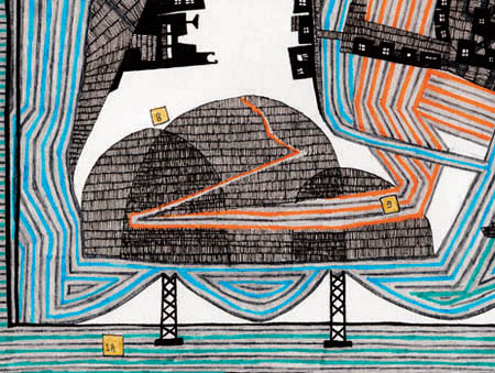
A Mighty City Constructed On A Series Of Variably-Sized Hilly Islands Linked By Bridges

[Image: A Mighty City Constructed On A Series Of Variably-Sized Hilly Islands Linked By Bridges by Leah Beeferman].

Brooklyn-based artist Leah Beeferman, whose map of the Gowanus Canal appeared here in 2005 and who collaborated with BLDGBLOG on the Helicopter Archipelago, has a new project out, this time published in the full-color pages of this month’s Blueprint.
Called A Mighty City Constructed On A Series Of Variably-Sized Hilly Islands Linked By Bridges, the project is a kind of cartographic guide, or urban emblem, for a utopian city. It supplies working definitions of key terrain (a Bridge, a Hill, a Tunnel, an Island) and describes specifically numbered structures.
“A bridge,” for instance, according to Leah’s definition, “is a structure built to connect two previously distinct areas or coasts. In most cases, it creates a route of passage that would otherwise be impossible or difficult. Bridges are often named after what they cross.”

[Image: Excerpt from A Mighty City by Leah Beeferman].

All of Leah’s projects being worth paying close attention to, we then see that one of those bridges has actually been constructed “from a collection of the longest and tallest buildings in the world” – their spans and fragments stitched together to form a brand new structure.
There is also a bridge “made out of a building,” and a bridge “made from a collection of small hills.”
Further afield – and into the atmosphere – we find a strange hovering enginery above the skyline: “Flying machines for higher-up views of the city,” we read, “provide an excellent view of the islands.”
There are even “propeller-powered balconies, for long-term viewing of the surrounding landscape – from the comfort of home!”
Leah’s Mighty City is apparently just one installment in Blueprint‘s ongoing look at imaginary cities or paper utopias, as it were; keep your eyes peeled for the rest – but don’t forget to visit Leah Beeferman’s website for more cool projects, including her amazing Step-by-Step Process of Building a Landscape of Freshly Fallen Hills into an Industrious Winged City.

Cancer Villages

[Image: Via Blogger News Network].

The BBC reports today on China’s so-called cancer villages.
In Shangba, for instance, a “river runs to the side of the village, its shallow waters rippling over smooth stones. In the past,” the BBC writes, Shangba’s “villagers relied on the river for drinking water, and to irrigate their crops. What they did not know was that mines further upstream were dumping their waste into it.”
Run-off from the mines has now built up as “a thick red residue at the water’s edge” – yet a suitable source for clean water has not been found.
China’s problems with cancer are obviously not limited to Shangba. “This is a situation repeated across China,” the BBC continues. “Some 320 million people drink polluted water every day.” The Telegraph calls these polluted sources China’s cancer rivers.
Last year, Common Dreams pointed out that the exact connection between pollution, drinking water, air quality, and China’s rising cancer rate is actually harder to make than you’d think. For instance, “lack of evidence remains a problem as local government officials pressure doctors into staying silent over the link between pollution and the high cancer rate.”
Meanwhile, air pollution in China is so bad that the country has generated “toxic clouds so big that they can seen from space, drifting across the Pacific to California laden with microscopic particles of chemicals that cause cancer and diseases of the heart and lung.”
Thanks, China!

[Image: Via Stefan Landsberger’s Chinese Propaganda Poster Pages].

Parts of China now see “darkness at noon”:

Cancer rates are soaring, child health is a time bomb and the population, many of whom are heavy cigarette smokers, are paying the price for China’s breakneck rush to riches and industrialisation – an estimated 400,000 premature deaths nationwide because of pollution every year.

All of which continues to point toward the militarization of China’s natural resources, wherein once wild rivers will be replaced with bottled water trucked in from afar – an artificialization of the riverine world explored last year on BLDGBLOG as “hydrology under military escort.”

Seeing the forest for the tree

Lawrence Weschler’s Convergence of Convergences Contest over at McSweeney’s revisits the above photo of a clear-cut forest in Sweden – where the void left behind by logging has visually reproduced the very thing that void destroyed. The return of the repressed, indeed…

(Image of Swedish forest originally submitted to McSweeney’s by Walter Murch).