[Image: Curiosity pokes its heavily instrumented “head” around the Red Planet; photo courtesy of NASA and U.S. taxpayers].
Clancey’s look at the “robotic geologists” humans have sent to Mars over the past decade explores the strange phenomenon of science-at-a-distance, pursued, measured, recorded, and analyzed by human controllers located on another planet.
This is, in Clancey’s words, “a unique human-robotic enterprise,” by way of “teleoperated robots” or “telerobotic tools.”
[Image: Curiosity looks back at the “Morse road” it has created; photo courtesy of NASA].
The book is very much academic—i.e. it is not a New Yorker-style profile of mission scientists in their lab at Pasadena—but it nonetheless reveals the bizarre methodological requirements of working on another planet through remotely controlled machine-surrogates. From altered sleep-patterns (to keep pace with the longer days on Mars) to darkened window shades (to enact on Earth the darkness of the Martian nightfall for rovers), the actual practices of the scientists come to the foreground of Clancey’s study.
It is through these practices that the humans can engage with and control—or at least efficiently keep track of—these radically off-site prosthetic extensions, the rover now understood as “a mechanism that can be ‘acted through,’ an extended embodiment of the human eyes and hands of the people who control its actions from Earth.”
It is a remotely operated surrogate sensory apparatus—organs without a body.
[Images: Curiosity on Mars; photos courtesy of NASA].
Yet, even as these deliberately chosen images show—images taken by me from NASA‘s website, not from Clancey’s book—it is hard to resist what Clancey himself takes critical issue with, which is the personification of these “robot geologists” as they trundle around the Martian environment, peering at things, laser-zapping rocks, craning their heads—”heads”—around like ostriches and setting off across the landscape afresh, solar-recharged, every morning.
[Image: Curiosity on Mars; photo courtesy of NASA].
Emotionally identifying with the Mars rovers not only leads to the use of anatomical metaphors, such as those present in the previous sentence; it also, Clancey argues, clouds the notion of what it means to do science at all. “These inspirational descriptions have a place,” he writes in the book’s introduction, “but we must understand this new technology and articulate how it has worked so well if we are to know how to use and improve it.” Overarching questions about how humans and robots might exchange their roles in this undertaking—whether it’s the phrase “robot geologists” or a reversal of this situation with computer-guided “human tools” more like the astronauts in 2001—are, he writes, “technically and philosophically confused.”
The obvious benefit of non-scientific attachment between humans and their charismatic machines is that it is exactly these identifications that catalyze public enthusiasm for extraordinarily expensive scientific expeditions. But debunking myths of robot charisma is only part of Clancey’s purpose, as his book begins, instead, with a more or less anthropological study of the Earth-bound laboratory and the constantly changing teams of human beings within it, as they deploy and operate long-distance geologic tools, naming the terrain, mapping the landmarks, coordinating survey information, and chemically sensing the Martian landscape through surrogate “bodies” of complex instrumentation.
In other words, we might be busy anthropomorphizing machines, but the humans actually engaged with these off-world robotic tools are themselves realizing how they must adapt to the needs of the devices, to the tools’ own scientific and sensory limits, and to what these instruments can and cannot do in as distant a location as Mars.
[Image: Curiosity on Mars; photo courtesy of NASA].
In any case, Clancey’s book is worth checking out if this sort of thing interests you. However, it seems worth noting here briefly that this could also be put into the context of, say, art historian Barbara Maria Stafford’s 2001 essay on “devices of wonder,” or the interpretive machines and intermediary technical instruments that “not only constrain what it is possible to see but also determine what can be thought” by those who use them; as well as the idea, mentioned previously, of the “prosthetic imaginary,” or “a more metaphorical notion of the ‘prosthetic’ as an extended tool that becomes a proxy, or a substitute for experience.”
Rats, in particular, reveals a perspective on the city so often overlooked and perhaps so revolting—the city as seen through the eyes of professional pest specialists and rat catchers—that it is unfortunately quite easy to miss the fascinating insights into New York’s history that such a viewpoint entails. From archaeology—discovering that now long-buried earthworks from the Revolutionary War are still breeding grounds for rats—to rat-resistant material science, where steel wool is mixed into concrete to slow the animals’ ability to chew through walls, Sullivan’s book is memorable, worthwhile, and hard to stop thinking about once you’re through.
I’m thus very much looking forward not only to meeting Robert Sullivan in person next week, but doing so as part of a public event at Studio-X NYC. That will be a live interview—free and open to the public—hosted in recognition of Sullivan’s newest book, My American Revolution: Crossing the Delaware and I-78.
This new book is premised on two main themes: the terrain and weather of New York City, and how these both worked to shape the Revolutionary War against English troops in the 18th century. These “founding landscapes,” in Sullivan’s words, literally guided and formed those events—a fairly obvious claim, of course, but one that takes on the air of an archaeological expedition or a landscape detective story as Sullivan sets off by car, boat, and, most importantly, foot to track down the old routes, campgrounds, overlooks, signaling hills, and other waypoints used to such liberating effect nearly 250 years ago.
As Sullivan phrases it, “I began to work like a scout, going out on reconnaissance missions into a landscape that might not appear ancient, camouflaged as it is by cities and strip malls, by toxic waste sites, and high-end commercial properties.” Or, in the words of the New York Times, for Sullivan, “history is not so much a collection of dates and facts but actual places you can revisit—layers of geography that can be excavated one by one.”
After all, as anyone interested in military history will already know, winning a battle—let alone an entire war—comes down in many ways simply to a more strategically informed use of the landscape, beyond even the quality or impact of the weapons at hand; and Sullivan uses the book to suggest that the topography and the climate of the New York region opened certain opportunities while foreclosing others for the colonial insurgents. This is done in typical Sullivan fashion, mind you; the Washington Post, for instance, calls the book “almost entirely eccentric” and “about as far from a conventional account of that conflict as one could get,” yet both of these are meant in a positive sense. It is a book of asides, footnotes, detours, and second thoughts.
[Image: A map of selected Revolutionary War sites and landscapes in greater New York, courtesy of Robert Sullivan].
In any case, we’ll be talking to Sullivan about his new book—as well as about rats and the Meadowlands and much more—at 6:30pm on Tuesday, October 16th. We’ll also get a sneak peek at some of the behind-the-scenes techniques Sullivan uses to write his books, including his fascinating personal books about his books: part collage, part notebook, part bound filing system, these books-of-the-books detail Sullivan’s own process of writing and assembling the eventual published artifact.
Jaffe’s own tour through the overlooked—and ongoing—militarization of the New York landscape, from Wall Street (named after the literal defensive wall that once stood on the site) to the coastal fortifications that still stand in places along the NYC shoreline, is a compelling and unforgettable read. Getting Jaffe and Sullivan to speak together at Studio-X NYC, perhaps, about their work would be a fascinating possibility.
[Image: The “keys to the city,” via the New York Post. One key description reads: “What you could do: Take over the subways”].
A set of “master keys” to the infrastructure of New York City popped up on eBay last month, leaving many public commentators and city officials alike concerned for the safety of the metropolis.
It’s “what a terrorist might call a dream come true,” the New York Post suggests:
The set consists of five keys that would allow control of virtually any elevator in the city, could knock out power to municipal buildings and skyscrapers, darken city streets, open subway gates and some firehouse doors and provide full access to 1 World Trade Center and other construction sites.
After the keys were sold to a buyer who was actually “an undercover Post reporter,” an investigation found that “most of the keys did, in fact, work.” And they can do quite a lot:
The keys include the all-purpose “1620,” a master firefighter key that with one turn could trap thousands of people in a skyscraper by sending all the elevators to the lobby and out of service, according to two FDNY sources. And it works for buildings across the city. That key also allows one to open locked subway entrances, gain entry to many firehouses and get into boxes at construction jobs that house additional keys to all areas of the site. The ring sold to The Post has two keys used by official city electricians that would allow access to street lamps, along with the basement circuit-breaker boxes of just about any large building.
One thing I mentioned last month during the “Applied Topology” lecture at UC-Berkeley was the potential to produce 3D replicas of keys based simply upon visual documentation of the target key set.
For instance, research by Tamara Denning, Cynthia Matuszek, Karl Koscher, Joshua R. Smith, and Tadayoshi Kohno at the University of Washington—see this PDF—has suggested that “household robots,” in their words, could be used someday to commit home burglary.
In a situation as notable for its comedic potential as for its criminal ingenuity, belligerent hackers could thus wirelessly take control of your “household robots”—Denning’s group chose the Robosapien, Rovio, and Spykee for testing—and surreptitiously gain access to information about your house. Room layout, location of motion sensors, whether or not a certain door has been locked at night, if anyone is even home, or, more directly, where certain things, like jewels, cash, pharmaceuticals, or a handgun, might be kept.
The most plausible scenario the team came up with involved something like a robot still-life, an American Gothic with keys: the Robosapien would simply grab ahold of your house keys and the Rovio would then sit there filming it.
[Images: From research by Tamara Denning, Cynthia Matuszek, Karl Koscher, Joshua R. Smith, and Tadayoshi Kohno at the University of Washington].
This cinematographic duo would thus pose there looking at each other, under the control of hackers huddling in a van somewhere wearing Stadium Pals, long enough that they could 3D-map the keys from the ensuing image feed and then have accurate copies produced. Thus would your house be robbed by robot.
All of which is a long-winded way of saying: surely someone could now produce, given enough dedication and perhaps a metal-based 3D printer, hypothetical copies of these “keys to the city” and shortly find him- or herself clicking open locked subway doors, turning off streetlights, stalling elevators, even redirecting construction site equipment to produce off-kilter towers in midtown? Using nothing more than a few glimpses of the keys found online and some late-night field-testing, the keys are cloned and begin to proliferate.
3D-printed lock-picking kits, with near-universal access to the city, from elevators to subway cars to private apartments, can only be, worryingly, a few years away.
Going back through dozens and dozens of links saved over the past few months, I rediscovered two quick news items I thought I’d post together, both of which involve automatic garage doors.
U.S. Navy officials have acknowledged on Monday that a radio signal being transmitted out of the Groton Submarine Base is likely the cause behind the residents’ garage-door woes. The signal is part of the Enterprise Land Mobile Radio (ELMR) system, which is used by the military to coordinate responses with civil emergency workers, said Chris Zendan, a spokesman for the submarine base in Groton.
In short, it seems that frequencies used by remote-control garage door openers overlap with signals put back into service after 9/11 for communicating during civil emergencies.
However, putting this into the context of several recent articles about the accelerating pace of “cyber-attacks” on U.S. infrastructure—that is, “the pace at which America’s electricity grids, water supplies, computer and cellphone networks and other infrastructure are coming under attack,” in the words of the New York Times—as well as news that New York City’s elevators and boilers are now seen as potential targets for cyberwarfare (hackers “could increase the speed of how elevators go up or down,” perhaps crashing them to the bottom of the shaft), the idea of garage doors being hacked by radio signals emanating from the ocean by belligerent foreign powers takes on the air of, say, Red Dawn as remade by Bob Vila. Or it could be the plot of a bizarre future heist film: a sleepy coastal town in Oregon, its every house and building, robbed by submarine.
Just two weeks ago, meanwhile, over-heated headlines proclaimed that “Chinese hackers have control of U.S. power grid,” but perhaps we can imagine, instead, a far less threatening scenario, in which Chinese hackers manage to take control of every garage door in a small town in southern Georgia. Indescribably ignorant politicians proclaim it the work of Satan—but it’s just distant teenage poltergeists, high-fiving each other over cans of Diet Coke and trapping families in their 4-car garages.
2) Former professional wrestler Hulk Hogan had back surgery a while back—and the resulting spinal implant has given him the power to open garage doors from afar. In an otherwise idiotic article that explains how “Hulk Hogan Has Battery Powered Back,” one of the wrestler’s friends jokes that, “When he’s walking down a small neighborhood [sic] he opens every garage door on the street!” Talk about the prosthetic imaginary.
[Image: If Hulk Hogan pushes real hard, his garage door opens].
Next year’s headline: Chinese hackers in control of Hulk Hogan’s back open every garage door in Connecticut.
As a brief follow-up to the Lost Rivers trailer—and the full film debuts in less than one week’s time, on Wednesday, October 10th, at Toronto’s “Planet In Focus” Environmental Film Festival—it’s worth taking a look at a recent post on the excellent blog L.A. As Subject.
[Image: Older versions of Los Angeles: “1943 view of the Macy Street viaduct over the Arroyo de las Pasas’ former route. Today, the bridge carries Cesar Chavez Avenue over the Interstate 10 freeway.” Photo and caption via L.A. As Subject].
There, we read that the older, wilder geography of Southern California still breaks through the surface of the city—including lost rivers. Tracking down these older versions of Los Angeles takes research: “Archives have played a key role in rediscovering another forgotten feature of L.A.’s wild geography: the extensive system of creeks, arroyos, and other watercourses that once flowed through present-day Los Angeles.”
Fed by springs issuing from vast underground aquifers, storm runoff, or some combination of the two, these streams once crisscrossed the entire city. Today, many of them have suffered a similar fate as the Los Angeles River: paved over, buried and converted into storm drains, or eliminated altogether. Most Angelenos walk or drive over them every day without realizing it.
The post’s author, Nathan Masters, points us toward L.A. Creek Freak, a blog by Jessica Hall. “By studying the maps, photographs, and other documents preserved in the region’s archives,” Masters writes, “Hall has reconstructed a surprisingly wet L.A. landscape, braided with dozens of streams that now lie buried beneath streets and parking lots.”
[Image: A satellite view “overlaid with L.A.’s historical streams and wetlands. Courtesy of Jessica Hall, L.A. Creek Freak,” via L.A. As Subject].
Masters also links to a great old profile of Hall’s work on L.A. Weekly, first pointed out to me by Nicola Twilley a few years ago, during a conversation about the Tyburn Angling Society, that contains this awesome image:
“Do you know why there’s sometimes fog at the intersection of Beverly and Rossmore?” Hall asks. “It’s because there’s a perennial creek that runs through the country club there,” she says. “It goes underground beneath Beverly, and comes up again on the other side.”
Urban fog banks as tracking markers for underground streams!
As usual, L.A. As Subject includes some great archival photographs with their post, so it is worth clicking through—and scrolling down—to see them.
While you’re there, however, don’t miss their look at “why L.A. has clashing street grids,” the history of Chavez Ravine, or—one of my personal favorites—an incredible look at the “lost hills of Los Angeles” (previously mentioned on BLDGBLOG here). The center of the city is a history of terrain deformation, advanced topology in built form, as tunnels turn to streets because the hills they were cut through no longer exist.
I’m intrigued by the architectural possibilities of “gossamer systems,” a term referring to the design of ultra-lightweight—or perhaps ultra-thin is more accurate—systems for spacecraft design.
According to a recent online course description from the American Institute of Aeronautics and Astronautics, “an evolving trend in spacecraft is to exploit very small (micro- and nano-sats) or very large (solar sails, antenna, etc.) configurations. In either case, success will depend greatly on [the use] of ultra-lightweight technology, i.e., ‘gossamer systems technology.’ Areal densities of less than 1 kg/m2 (perhaps even down to 1 g/m2!) will need to be achieved.”
That exclamation point, present in the original text, is well-justified: structures that weigh one gram per square-meter! While obvious comparisons can be made here with super-light spaceframes and other widely familiar engineering achievements of the past few decades, pushing terrestrial structures toward this seemingly impossible vanishing point—buildings so thin and ethereal, they are, in a sense, no longer even physically present—would be a fascinating challenge for a structures class somewhere.
In fact, let’s just make it an actual design challenge, architecture’s equivalent of the X Prize: combining origami, aerodynamism, spacecraft physics, materials science, athletic equipment, and more, design and fabricate a building the size of Manhattan that weighs less than one pound. Go!
The trailer for Lost Rivers has been released, a film I’ve been looking forward to seeing since meeting Katarina Soukup, the film’s producer, way back in the summer of 2010.
“Once upon a time, in almost every city,” the film states, “many rivers flowed. Why did they disappear? How? And could we see them again? This documentary tries to find answers by meeting visionary urban thinkers, activists and artists from around the world.”
I’m not sure what the schedule is for forthcoming screenings of the final feature, but you can follow the film on Twitter to stay updated.
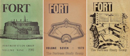
[Images: Covers from old copies of Fort, the Fortress Study Group member publication].
While writing the previous post and looking for a link to FSG, Robin Sloan’s publisher, a fortuitous auto-fill in my browser bar led me to the Fortress Study Group, the “international society of artillery fortification and military architecture.” Their site includes a helpful series of PDFs on the architectural history of fortification, or “the development of fortifications designed to resist artillery,” including this long look back at the group’s most recent “study tour” (similar in many ways to the Fortifications Tour we explored on BLDGBLOG long ago).
Of particular note: through their site, we learn that a symposium called Fortifications at Risk 2 will be held in March 2013 at the National Army Museum in London, discussing “how derelict fortifications may be preserved and re-used” for future purposes. You can register here.
Briefly, I’m reminded of historian Steven Jaffe’s fascinating book, New York at War: Four Centuries of Combat, Fear, and Intrigue in Gotham, in which Jaffe details the construction of coastal forts and artillery batteries throughout New York City, from colonial times to the Civil War (and beyond).
In particular, Jaffe cites the work of inaugural West Point superintendent Jonathan Williams, “mastermind of New York’s harbor fortifications,” in Jaffe’s words, who designed and proposed “a network of new fortifications placed strategically” at the marine entrances to the city during the War of 1812. His designs included “stone and mortar citadels” peppering the shores and “a line of massive stone blocks” that would be dropped into the harbor waters, forming a kind of submerged gate topped with barrier chains and artillery, further closed in places by the hulls of deliberately scuttled ships, seemingly an architecture equal parts wreckage and military geometry.
The majority of Williams’s defensive plan was never built; however, Castle Williams on Governors Island, which we boated past last week as part of Dredgefest 2012, is still there in its circular ruin, not far from the massive unmarked ventilation structure for the Brooklyn-Battery Tunnel which roars beneath the harbor waters.
An unbuilt fortifications tour of New York City is thus quite an interesting prospect.
The release of Robin Sloan’s first novel, Mr. Penumbra’s 24-Hour Bookstore, with its glow-in-the-dark book jacket, kicks off with a 24-hour launch party tonight at New York’s Center for Fiction, featuring a long series of interviews, conversations, and guests.
Nicola Twilley and I will be some of the many people participating; we’ll be talking to Robin about, in his words, “vast storage spaces” for everything from books and national gold reserves to strategic food stockpiles and nuclear waste, riffing off of the coded book-spine library patterns and semi-autonomous warehouse memory systems found in Robin’s book. That particular conversation takes place tonight at midnight.
A few examples of landscapes waking up after long periods of time lying dormant have been in the news recently.
[Image: Maria Thereza Alves’s Seeds of Change garden, via Facebook].
First, there is artist Maria Thereza Alves’s “ballast seed garden” project, called Seeds of Change, which arose from a moment of revelation:
Between 1680 and the early 1900s, ships’ ballast—earth, stones and gravel from trade boats from all over the world used to weigh down the vessel as it docked—was offloaded into the river at Bristol. This ballast contained the seeds of plants from wherever the ship had sailed. Maria Thereza Alves discovered that these ballast seeds can lie dormant for hundreds of years, but that, by excavating the river bed, it is possible to germinate and grow these seeds into flourishing plants.
While Alves seems not to have literally dug down into the old layers of the river in order to harvest her seeds—instead sourcing contemporary examples of species known to have sprouted from mounds of ballast over the last few hundred years—her project nonetheless has the character of a long-lost landscape waking up, popping up like a refugee amidst the rubble in a return to visibility.
This idea of accidental ballast gardens—heavily detoured landscapes-to-come lying patiently in wait before springing back to life several centuries after their initial transportation—is incredible; I might even suggest parallels here with such 21st-century problems as how we might sterilize spacecraft before sending them offworld, to places like Mars, lest we, in a sense, bring along our own bacterial “ballast” and thus unwittingly terraform those distant locations with escaped landscapes from Earth. Might we someday culture “ballast gardens” on other planets from the tiniest of remnant organic compounds found on our own ancient and dismantled ships?
[Image: Maria Thereza Alves’s Seeds of Change garden, via Facebook].
Meanwhile, in a headline that reads like something straight out of Stanislaw Lem or H.P. Lovecraft, we read that “Nunavut’s Mysterious Ancient Life Could Return by 2100 as Arctic Warms.” In other words, forests that thrived in the hostile conditions of “Canada’s extreme north” nearly three million years ago might return to re-colonize the landscape as the region dramatically warms over the next century due to climate change.
This is a relatively mundane resurrection—after all, it is just a forest—but even the suggestion that future climate conditions on Earth might re-awaken ancient ecosystems, dormant environments in which humans might find it less than easy to survive, is an incredible cautionary tale for the future of the planet. That, and this story offers the awesomely mythic image of human explorers wandering across the thawing earth of the far north as strange and ancient things bloom from cracks in the ground around them.
[Images: Various herbaria pages].
In both cases, I’m reminded of an essay published in Lapham’s Quarterly a few years ago, by novelist Daniel Mason. There, Mason writes about “nature’s return,” a scenario in which dormant and waylaid seeds thrive on the rubble of the present-day landscape. “In the dusty cracks between the concrete, seedlings would germinate, grow,” Mason writes, heralding unpredictable landscapes to come.
[Images: More herbaria pages].
However, referring to these remnant seeds left over from older landscapes, Mason writes that “most would not germinate straight away,” even if given free rein over an empty field or cracked streetscape. “Rather,” he adds, these seeds “would lodge in microscopic nooks and crannies, some to be eaten or crushed, others to be paved over, but most, simply, to wait. A square meter of urban soil can contain tens of thousands of seeds persisting in a state of suspended animation, waiting to be woken from their slumber. After the fire brigades rescued the London Natural History Museum from German incendiaries, Albizia silk-tree seeds bloomed on their herbarium sheets, liberated from two hundred years of dormancy by the precise combination of flame and water.”
A square meter of urban soil can contain tens of thousands of seeds persisting in a state of suspended animation, waiting to be woken from their slumber. In Mason’s words, this return of dormant life “suggests the parallel existence of a hidden world, fully formed, simply awaiting the opportunity for expression.”
Whether dredging up old riverbeds full of ballast from previous centuries, or watching new storms form over the Arctic, bringing back climates unseen for millions of years, what might yet wake up from the ground around us, return from dormancy, resurrect, as it were, and make itself at home again on a planet that thought it had since moved on?
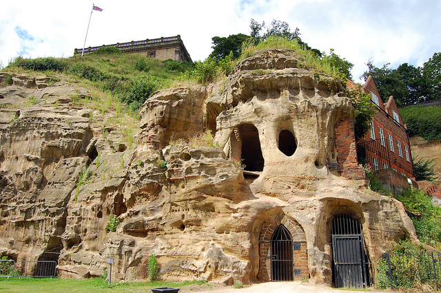
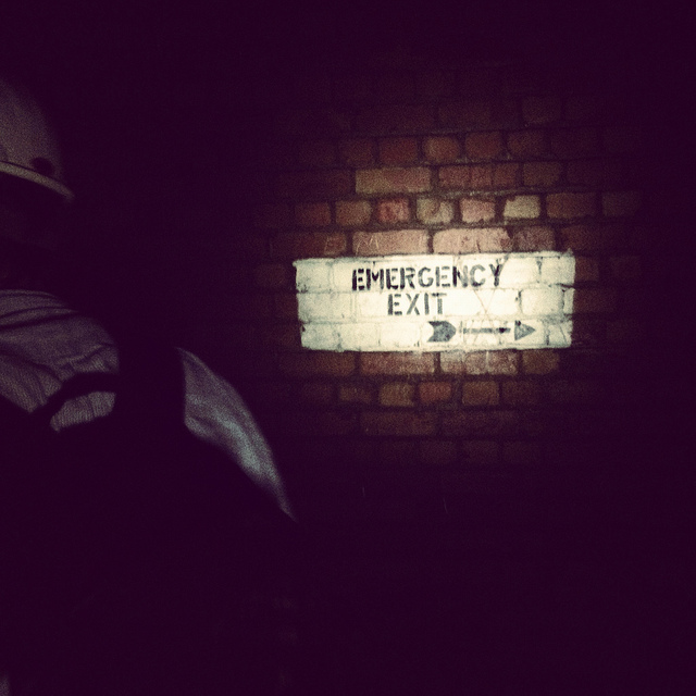
[Image: Cliffs and caves of Nottingham; photo by Nicola Twilley].
For severalyears now, I’ve admired from afar the ambitious laser-scanning subterranean archaeological project of the Nottingham Caves Survey.
Incredibly, there are more than 450 artificial caves excavated from the sandstone beneath the streets and buildings of Nottingham, England—including, legendarily, the old dungeon that once held Robin Hood—and not all of them are known even today, let alone mapped or studied. The city sits atop a labyrinth of human-carved spaces—some of them huge—and it will quite simply never be certain if archaeologists and historians have found them all.
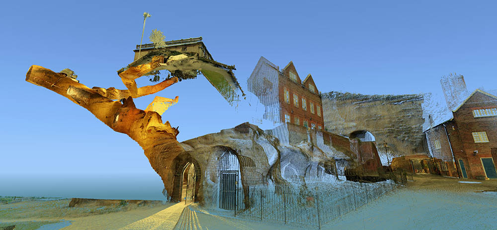
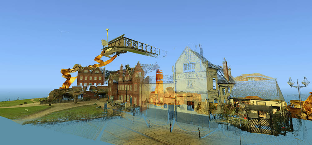
[Images: Laser scans from the Nottingham Caves Survey show Castle Rock and the Mortimer’s Hole tunnel, including, in the bottom image, the Trip to Jerusalem Pub where we met archaeologist David Strange-Walker; images like this imply an exhilarating and almost psychedelic portrait of the city as invisibly connected behind the scenes by an umbilical network of caves and tunnels. Scans courtesy of the Nottingham Caves Survey].
“Even back in Saxon times, Nottingham was known for its caves,” local historian Tony Waltham writes in his helpful guide Sandstone Caves of Nottingham, “though the great majority of those which survive today were cut much more recently.” From malt kilns to pub cellars, “gentlemen’s lounges” to jails, and wells to cisterns, these caves form an almost entirely privately-owned lacework of voids beneath the city.
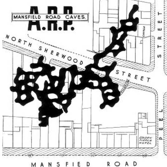
[Image: Map of only the known caves in Nottingham, and only in Nottingham’s city center; map by Tony Waltham, from Sandstone Caves of Nottingham].
As Waltham explains, “Nottingham has so many caves quite simply because the physical properties of the bedrock sandstone are ideal for its excavation.” The sandstone “is easily excavated with only hand tools, yet will safely stand as an unsupported arch of low profile.”
In a sense, Nottingham is the Cappadocia of the British Isles.
The purpose of the Nottingham Caves Survey, as their website explains, is “to assess the archaeological importance of Nottingham’s caves. Some are currently scheduled monuments and are of great local and national importance. Some are pub cellars and may seem less vital to the history of the City.”
Others, I was soon to learn, have been bricked off, taken apart, filled in, or forgotten.
“All caves that can be physically accessed will be surveyed with a 3D laser scanner,” the Survey adds, “producing a full measured record of the caves in three dimensions. This ‘point cloud’ of millions of individual survey points can be cut and sliced into plans and sections, ‘flown through’ in short videos, and examined in great detail on the web.”
[Video: One of very many laser-scan animations from the Nottingham Caves Survey].
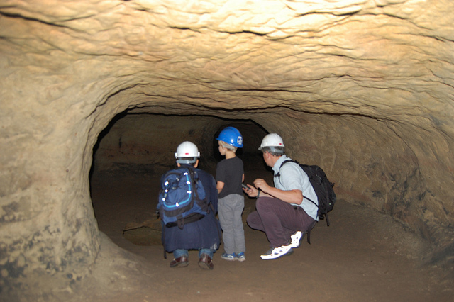
While over in England a few weeks ago, I got in touch with archaeologist David Strange-Walker, the project’s manager, and arranged for a visit up to Nottingham to learn more about the project. Best of all, David very generously organized an entire day’s worth of explorations, going down into many of the city’s underground spaces in person with David himself as our guide. Joining me on the trip north from London was Nicola Twilley of Edible Geography; architect Mark Smout of Smout Allen and co-author of the fantastic Pamphlet Architecture installment, Augmented Landscapes; and Mark’s young son, Ellis.
[Image: Artificially enlarged pores in the sandstone; photo by BLDGBLOG].
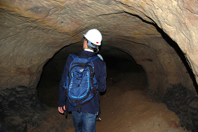
We met the very likable and energetic David—who was dressed for a full day of activity, complete with a well-weathered backpack that we’d later learn contained hard hats and floodlights for each of us—outside Nottingham’s Trip to Jerusalem pub.
Rather than kicking off our visit with a pint, however, we simply walked inside to see how the pub had been partially built—that is, expanded through deliberate excavation—into the sandstone cliffside.
The building is thus more like a facade wrapped around and disguising the artificial caves behind it; walking in past the bar, for instance, you soon notice ventilation shafts and strange half-stairways, curved walls and unpredictable acoustics, as the “network of caves” that actually constitutes the pub interior begins to reveal itself.
My mind was already somewhat blown by this, though it was just the barest indication of extraordinary spatial experiences yet to come.
[Image: Examining sandstone with Dr. David Strange-Walker; photo by BLDGBLOG].
Wasting no time, we headed back outside, where afternoon rain showers had begun to blow in, and David introduced us to the sandstone cliff itself, pointing out both natural and artificially enlarged pores pockmarking the outside.
The sandstone formations or “rock units” beneath the city, as Tony Waltham explains, “were formed as flash flood sediments in desert basins during Triassic times, about 240 million years ago, when Britain was part of a hot and dry continental interior close to the equator. Subsequent eons of plate tectonic movements have brought Britain to its present position; and during the same time, the desert sediments have been buried, compressed and cemented to form moderately strong sedimentary rocks.”
The city is thus built atop a kind of frozen Sahara, deep into which we were about to go walking.
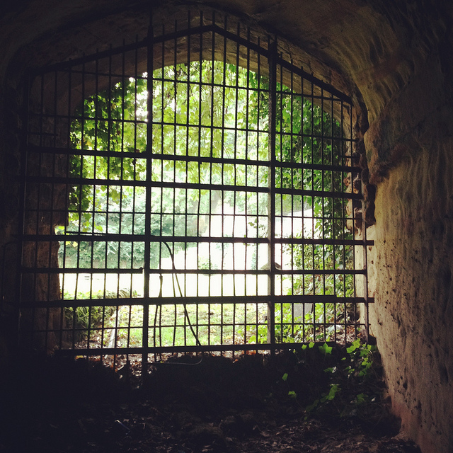
[Image: A gate in the cliff; photo by BLDGBLOG].
Outside here in the cliff face, small openings led within to medieval tunnels and stairs—including the infamous Mortimer’s Hole—that themselves curled up to the top of the plateau; doors in the rock further up from the Trip to Jerusalem opened onto what were now private shooting ranges, of all things; and, with a laugh, David pointed out shotcrete cosmetic work that had been applied to the outer stone surface.
[Image: Artificial shotcrete geology; photo by BLDGBLOG].
We headed from there—walking a brisk pace uphill into the town center—with David casually narrating the various basements, cellars, tunnels, and other urban perforations that lay under the buildings around us, as if we were traveling through town with a human x-ray machine for whom the city was an archaeologically rich cobweb of underground loops and dead-ends.
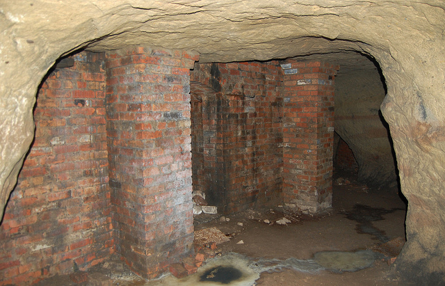
We soon ended up at the old jails of the Galleries of Justice. A well-known tourist destination, complete with costumed re-enactors, the building sits atop several levels of artificial caves that are well worth exploring.
We were joined at this point by the site’s director, who generously took time out of his schedule to lead us down into parts of the underground complex that are not normally open to the general public.
Heading downward—at first by elevator—we eventually unlocked a door, stepped into a tiny room beneath even the jail cells, crouching over so as not to bang our heads on the low ceiling, and we leaned against banded brick pillars that had been added to help support all the architecture groaning above us.
Avoiding each other’s flashlight beams, we listened as our two guides talked about the discovery—and, sadly, the willful reburial—of caves throughout central Nottingham.
[Image: Brick pillars below Nottingham; photo by BLDGBLOG].
We learned, for instance, that, elsewhere in the city, there had once been a vacuum shop with a cave beneath it; if I remember this story correctly, the shop’s owners had the habit of simply discarding broken and unsold vacuum cleaners into the cave, inadvertently creating a kind of museum of obsolete vacuum parts. Discontinued models sat in the darkness—a void full of vacuums—as the shop went out of business.
We heard, as well, about a nearby site where caves had been discovered beneath a bank during a recent process of renovation and expansion—but, fearing discovery of anything that might slow down the bank’s architectural plans, the caves were simply walled up and left unexplored. They’re thus still down there, underneath and behind the bank, their contents unknown, their extent unmapped—a fate, it seems, shared by many of the caves of Nottingham.
Rather than being greeted by the subterranean and historical wonder that such structures deserve—and I would argue that essentially all of subterranean Nottingham should be declared a UNESCO World Heritage Site—the caves are too often treated as little more than annoying construction setbacks or anomalous ground conditions, suitable only for bricking up, filling with concrete, or forgetting. If the public thinks about them at all, in seems, it is only long enough to consider them threats to building safety or negative influences on property value.
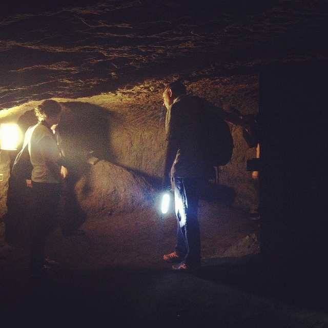
[Images: Learning about caves; photos by BLDGBLOG].
In any case, on our way out of the Galleries of Justice, we lifted up a ventilation grill in the floor and looked down into a small vertical shaft, too narrow and contorted even for Ellis to navigate, and we learned that there are urban legends that this particular shaft leads down to a larger room in which Robin Hood himself was once held… But we had only enough time to shine our flashlights down and wonder.
[Images: Ellis Smout looks for Robin Hood below; photos by BLDGBLOG].
From here, we headed over to our final tourist-y site of the day, which is the awesomely surreal City of Caves exhibition, located in Nottingham’s Broad Marsh shopping mall.
You literally take an escalator down into an indoor mall, where, amidst clothing outlets and food courts, there is an otherwise totally mundane sign pointing simply to “Caves.”
If you didn’t know about Nottingham’s extensive sub-city, this would surely be one of the most inexplicable way-finding messages in mall history.
Here, where we picked our copy of Tony Waltham’s Sandstone Caves of Nottingham pamphlet, from which I’ve been quoting, we learned quite a bit more about how the city has grown, how the caves themselves have often been uncovered (for example, during building expansions and renovations), and what role Nottingham’s underground spaces served during the Nazi bombings of WWII.
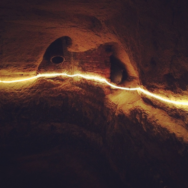
[Image: Beneath Broad Marsh shopping mall; photo by BLDGBLOG].
The specific underground complex beneath the shopping mall offers an interesting mix of old tanning operations and other semi-industrial, pre-modern work rooms, now overlapping with 20th-century living and basement spaces that were sliced open during the construction of the Broad Marsh mall.
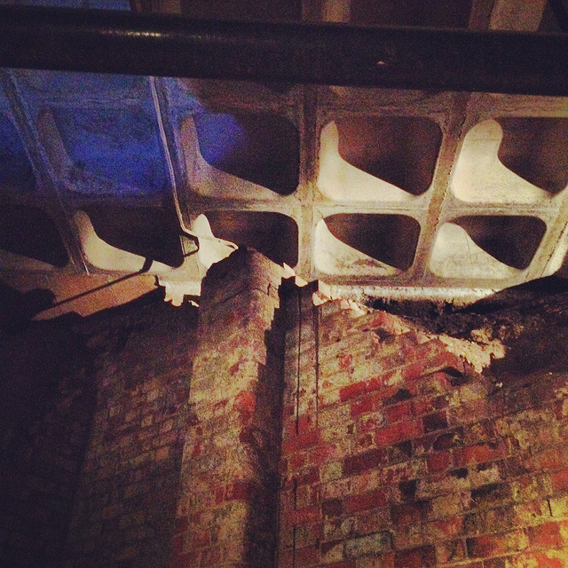
[Images: Cave spaces beneath the Superstudio-like concrete grid of Nottingham’s Broad Marsh shopping Mall].
That these caves were preserved at all is testament to the power of local conservationists, as the historically rich and spatially intricate rooms and corridors would have been gutted and erased entirely during post-War reconstruction without their intervention.
As it now stands, the mall is perched above the caves on concrete pillars, with the effect that curious shoppers can wander down into the caves through an entrance that could just as easily lead to a local branch of Accessorize.
[Image: A well bucket in the caves beneath Broad Marsh; photo by BLDGBLOG].
Again, we were fortunate to be taken down into some off-limits areas, stepping over lights and electric wires and peering ahead into larger rooms not on the tourist route.
[Images: Lines of lights we switched on in one of the off-limits rooms below Broad Marsh; photo by BLDGBLOG].
This included stepping outside at one point to wander through an overgrown alleyway behind the mall. Small openings even back here stretched beneath and seemingly into the backs of shops; one doorway, a short scramble up a hill of weed-covered rubble, appeared to contain a half-collapsed spiral staircase installed inside a brick-lined sandstone opening.
[Image: A doorway to voids behind Broad Marsh Centre; photo by BLDGBLOG].
At this point, we began to joke about the ease with which it seemed you could plan a sort of speleological super-heist, breaking into shops from below, as an entire dimension of the city seemed to lie unwatched and unprotected.
Nottingham, it appeared, is a city of nothing but doors and openings, holes, pores, and connections, complexly layered knots of space coiling beneath one building after another, sometimes cutting all the way down to the water table.
Incredibly, the day only continued to build in interest, reaching near-impossible urban sights, from catacombs in the local graveyard to a mind-bending sand mine that whirled and looped around like smoke rings beneath an otherwise quiet residential neighborhood.
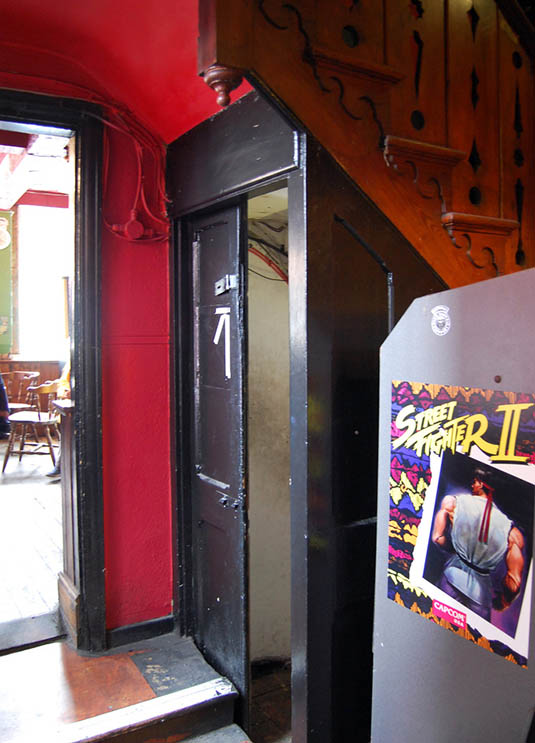
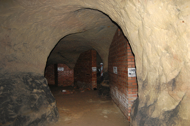
Leaving the mall behind, and maintaining a brisk pace, David took us further into the city, where our next stop was the Old Angel Inn, another pub with an extensive cellar of caves, in this case accessed through a deceptively workaday door next to an arcade game.
[Images: The Old Angel Inn (top), including the door inside the pub that leads down to the caves below; photos by Nicola Twilley].
Once again, it can hardly be exaggerated how easy it would be to visit or even live in Nottingham and have absolutely no idea that underground spaces such as this can be found almost anywhere. As Tony Waltham points out, “It would be a fair assumption that every building or site within the old city limits either has or had some form of cave beneath it. About 500 caves are now known, and this may be only half the total number that have been excavated under Nottingham.”
In any case, “Although the Old Angel is a ‘modern’ brick building,” as the Nottingham Caves Survey describes the pub on its website, “an investigation of the caves below reveals stone walls belonging to an earlier incarnation. It is likely that there were buildings on this site as far back as the Anglo-Saxon period. Whether the caves beneath are also this old cannot be demonstrated definitively.”
Typical, as well, for these types of pub caves, we found ventilation and delivery tunnels leading back up to the surface, and the walls themselves are lined with long benches, perfect for sitting below ground and, provided you have candles or a flashlight along with you, enjoying a smoke and a pint of beer. As Tony Waltham explains, pub cellars often include “perimeter thralls,” or “low ledges cut in the rock,” normally used for storing kegs and barrels of beer but quite easily repurposed for a quick sit-down.
But I sense I’m going on way too long about all this, especially because the two most memorable details of the entire day were yet to come.
Jumping forward a bit, we left the Old Angel and followed some twists and turns in the street to find ourselves standing outside a nightclub called Propaganda.
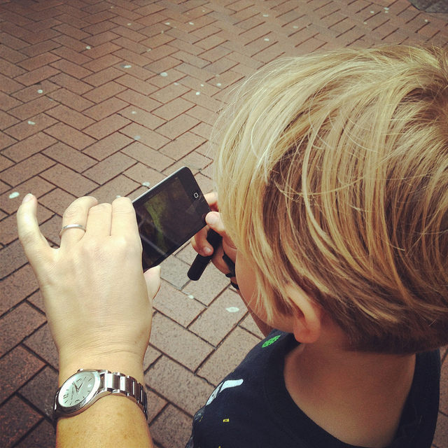
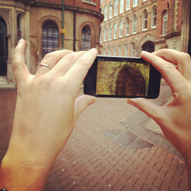
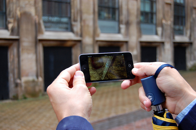
Here, David revealed that he has been working on what, in my opinion, will easily be one of the must-have apps of the year. In a nutshell, David has managed to make the subterranean 3D laser-scans of the Nottingham Caves Survey accessible by location, such that, holding up his iPod Touch, he demonstrated that you could, in effect, scan the courtyard we were standing in to see the caves, tunnels, stairways, cellars, vents, storage rooms, and more that lay hidden in the ground around us.
[Images: We test-drive the cave-spotting app; bottom photo by Nicola Twilley].
Ideally, once the Survey’s extensive catalog of 3D visualizations and laser point-clouds has been made available and the app is ready for public download, you will be able to walk through the city of Nottingham, smartphone in hand, revealing in all of their serpentine complexity the underground spaces of the city core.
For anyone who has ever dreamt of putting on x-ray glasses and using them to explore architectural space, this app promises to be a thrilling and vertiginous way to experience exactly that—peering right through the city to see its most ancient foundations.
[Video: A fly-through of the Propaganda Nightclub malting caves].
I, for one, can’t wait to see what David and the Nottingham Caves Survey do with the finished application and I eagerly await its public availability.
[Image: Mark Smout looks for caves in the sky; photo by Nicola Twilley].
I’ll wind up this already quite long post with just a few more highlights.
Nottingham’s Rock Cemetery, north from the center of town along the Mansfield Road, contains, among other things, the collapsed remains of a sand mine. Three of the mine’s old entrances are now gated alcoves surrounded by graves, like something out of Dante. They “are the only surviving remnants of the mine,” Waltham writes in his pamphlet.
[Images: Nottingham’s Rock Cemetery, where archaeologist David Strange-Walker explained the history of the local landscape].
However, an ambitious plan to carve sizable catacombs, inspired by Paris and Rome, through the sandstone beds of the ancient desert here resulted in the never-completed Catacomb Caves, “probably done in 1859-63,” Waltham suggests. These long arched tunnels, accessible through one of the gates described above, eventually lead to a radial terminus from which branch the unused proto-catacombs.
The air there is cloudy with sand—leading me, several days later, to experience a brief attack of hypochondria, worried about developing silicosis—the walls are graffiti’d, and years of trash are piled on the sides of the sandy floor (which has since taken on the characteristics of a dune sea in places, as 150 years of footfall and a collapsing ceiling have led to the appearance of drifts).
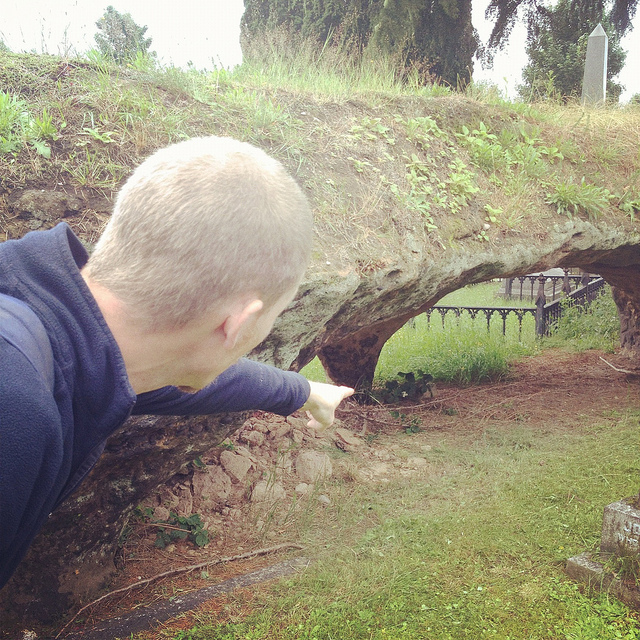
[Images: The Rock Cemetery catacomb gates].
What was so extraordinary here, among many other things, was that, for most of this walk through the catacombs, we were actually walking below the graves, meaning that people were buried above us in the earth. At the risk of overdoing it, this felt not unlike becoming aware of an altogether different type of constellation, with bodies and all the stories their lives could tell held above us in a terrestrial sky like legends and heroes, like Orion and Cassiopeia, as we looked up at the vaulted ceiling, flashlights in hand.
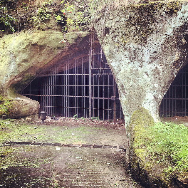
[Image: A door on the street—the black door with bars—leading down into a sand mine; photo by BLDGBLOG].
Serving as something of the ultimate proof that Nottingham is a city of overlooked doors that lead into the underworld, there were two locked doors—one of which (the black door, near the sidewalk) appears in the photo, above, another of which, on a street nearby, leads down into the Peel Street Caves—simply sitting there on the sidewalk that, if opened, will take you down into extensive and now defunct sand mines. David’s laser-scans of these for the Nottingham Caves Survey are absolutely gorgeous, as you can see, below.
For a variety of reasons, I am going to avoid being too specific about some of the details here, but, aside from that, I can only enthuse about the experience of donning our hard hats and heading down several flights of comparatively new concrete steps into a coiling and vast artificial cavern from the 19th century, one we spent nearly an hour exploring.
[Image: Nicola Twilley and Mark Smout head down into the sand mine; photo by BLDGBLOG].
Getting lost down there would be so absurdly easy that it is frightening even to contemplate, and, in case the group of us somehow got split up or our batteries ran out of juice, we joked about—if only we could remember them—the easy techniques for navigating a labyrinth offered in Umberto Eco’s novel The Name of the Rose.
[Image: Many of these way-finding signs are actually incorrect, David explained, and seem to have been painted as a kind of sick joke by someone several years ago; photos by BLDGBLOG].
Avoiding such a fate, however, we found graffiti and men’s and women’s latrines; we popped our heads through holes allowing glimpse of other levels; and we cracked our helmets loudly against the low and rough roof more times than I could count.
[Images: Inside the sand mine; all photos by Nicola Twilley].
And even that doesn’t complete the day. From here, heading back out onto the street through a nondescript steel door, as if we had been doing nothing more than watching football in someone’s basement, we went on to eat pie and chips in a restaurant built partially into a cave; we walked back across town, returning to where we started, talking about the future and seemingly obvious possibility of Nottingham’s caves being declared a UNESCO World Heritage Site and thus saved from their all but inevitable destruction (it’s easy to imagine a future in which a tour like the one David gave us will be impossible for lack of caves to see); and we all said goodbye beneath an evening sky cleared of clouds as a late-day breeze began to cut through town.
[Image: Mark & Ellis Smout explore our final “underground” space of the day, the magnificent Park Tunnel; the banded strata clearly visible in the walls show how the tunnel was carved through the dunes of an ancient desert. Photo by BLDGBLOG].
David proved to be a heroic guide that day. His energy never flagged throughout the tour, and he never once appeared impatient with or exhausted by any of our often ridiculous questions—not to mention our tourists’ insistence on pausing every three or four steps to take photographs—and he remained always willing to stay underground far longer than he had originally planned, all this despite having never met any of us before in person and only communicating with me briefly via a flurry of emails the week before.
Meeting David left me far more convinced than I already was that the Nottingham Caves Survey fully deserves the financial support of individuals and institutions, so that it can complete its ambitious and historically valuable work of cataloging Nottingham’s underground spaces and making that knowledge freely accessible to the general public.
Weirdly, England has within its very heart a region deserving comparison to Turkish Cappadocia—yet very few people even seem to know that this subterranean world exists. There very well could be more than 1,000 artificial caves beneath the city, many of them fantastically elaborate, complete with fine carvings of lions and ornate stairwells, and it is actually somewhat disconcerting to think that people remain so globally unaware of Nottingham’s underground heritage.
With any luck, the work of David Strange-Walker, Trent & Peak Archaeology, and the Nottingham Caves Survey will help bring this extraordinary region of the earth the attention—and, importantly, the focused conservation—it is due.
(For further reading, don’t miss Nicola Twilley’s write-up of the tour on her own blog, Edible Geography; and Tony Waltham’s Sandstone Caves of Nottingham, cited extensively in this post, is worth a read if you can find a copy).

 [Image: Curiosity pokes its heavily instrumented “head” around the Red Planet; photo courtesy of NASA and U.S. taxpayers].
 [Image: Curiosity looks back at the “Morse road” it has created; photo courtesy of NASA].
 [Images: Curiosity on Mars; photos courtesy of NASA].
 [Image: Curiosity on Mars; photo courtesy of NASA].
 [Image: Curiosity on Mars; photo courtesy of NASA].
 [Image: Robert Sullivan’s
  [Image: A map of selected Revolutionary War sites and landscapes in greater New York, courtesy of Robert Sullivan].
 [Image: The “keys to the city,” via the
  [Images: From research by Tamara Denning, Cynthia Matuszek, Karl Koscher, Joshua R. Smith, and Tadayoshi Kohno at the University of Washington].
 1) The U.S. Navy has been using a radio signal that seems to interfere with
  [Image: If Hulk Hogan pushes real hard, his garage door opens].
 [Image: Older versions of Los Angeles: “1943 view of the Macy Street viaduct over the Arroyo de las Pasas’ former route. Today, the bridge carries Cesar Chavez Avenue over the Interstate 10 freeway.” Photo and caption via
  [Image: A satellite view “overlaid with L.A.’s historical streams and wetlands. Courtesy of Jessica Hall, L.A. Creek Freak,” via L.A. As Subject].
 [Image: Via
  [Image: Via
 [Images: Covers from old copies of
 [Image: Maria Thereza Alves’s Seeds of Change garden, via

 [Images: The ballast garden, via
  [Image: Maria Thereza Alves’s Seeds of Change garden, via
  [Images: Various herbaria pages].
 [Images: More herbaria pages].
 [Image: Cliffs and caves of Nottingham; photo by
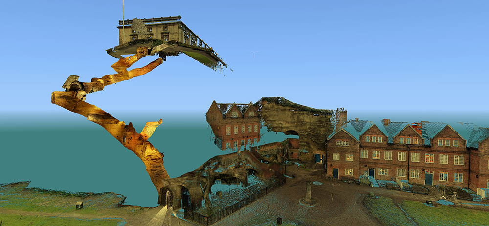
 [Images: Laser scans from the
 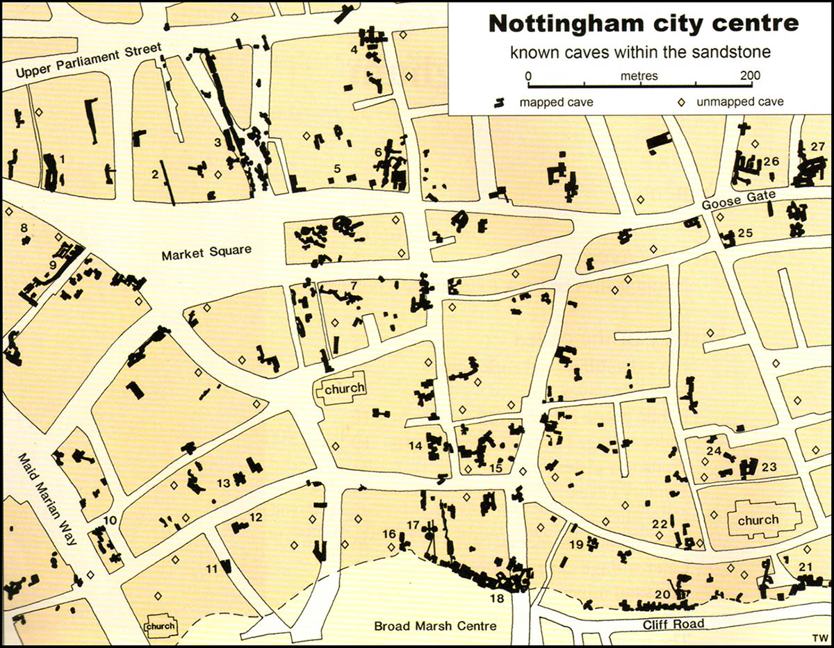 [Image: Map of only the known caves in Nottingham, and only in Nottingham’s city center; map by Tony Waltham, from
 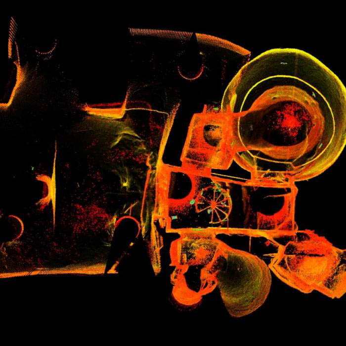 [Image: The extraordinary caves at
 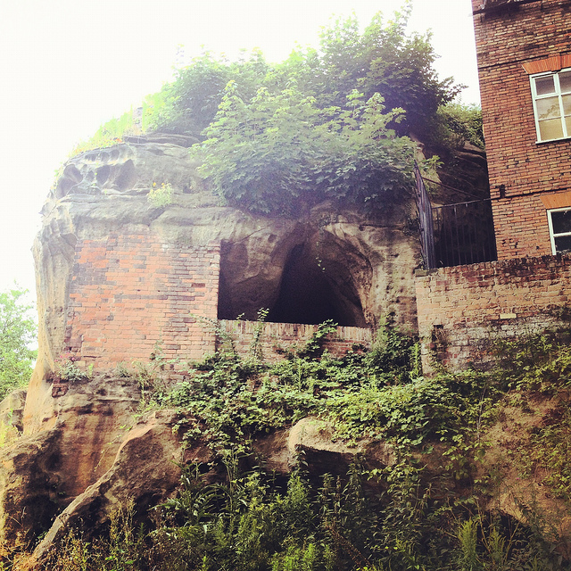 [Image: Artificially enlarged pores in the sandstone; photo by BLDGBLOG].
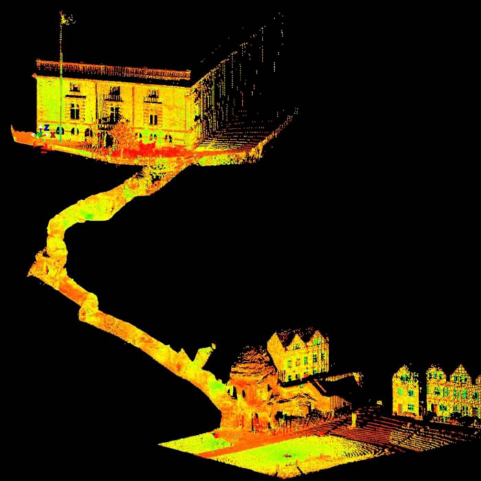 [Image: A laser scan showing the umbilical connection of
 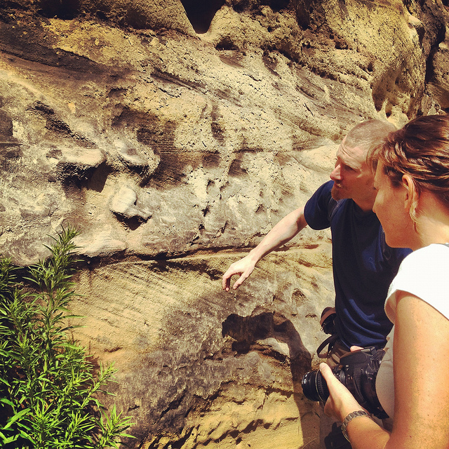 [Image: Examining sandstone with Dr. David Strange-Walker; photo by BLDGBLOG].
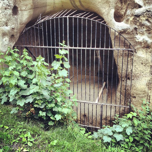 [Image: A gate in the cliff; photo by BLDGBLOG].
 [Image: Artificial shotcrete geology; photo by BLDGBLOG].
 [Image: Scan of the Guildhall caves, courtesy of the
 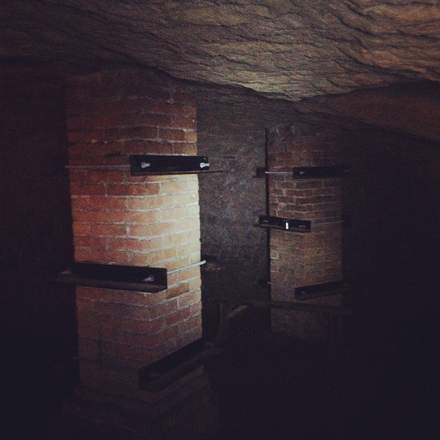 [Image: Brick pillars below Nottingham; photo by BLDGBLOG].
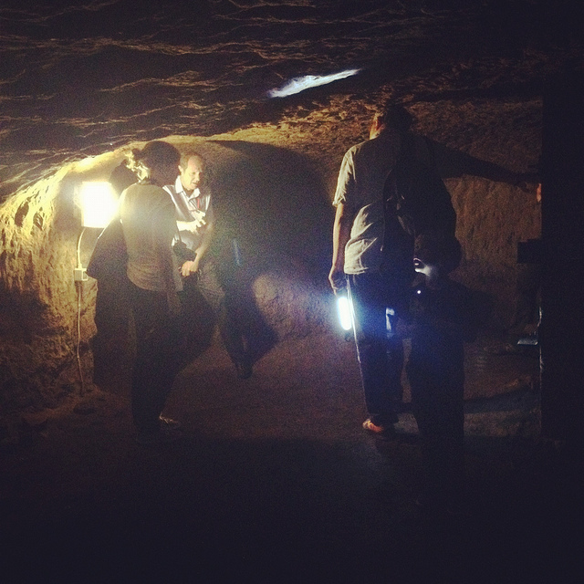
 [Images: Learning about caves; photos by BLDGBLOG].
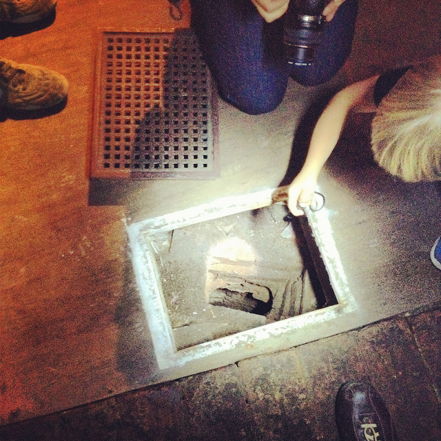
 [Images: Ellis Smout looks for Robin Hood below; photos by BLDGBLOG].
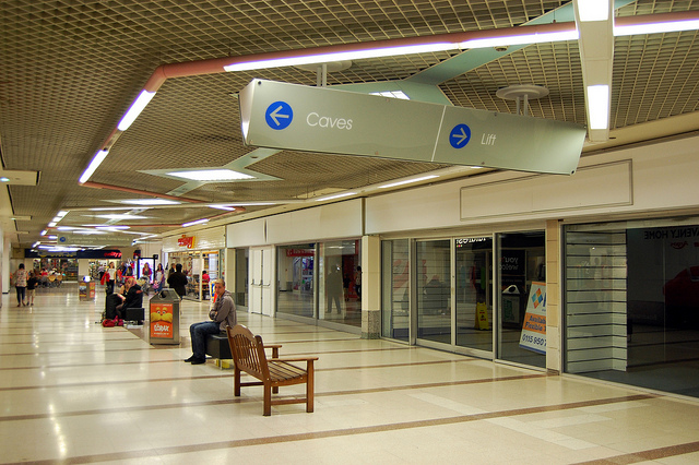 [Image: Caves; photo by
 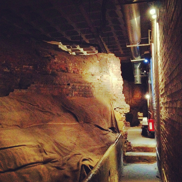 [Image: Beneath Broad Marsh shopping mall; photo by BLDGBLOG].
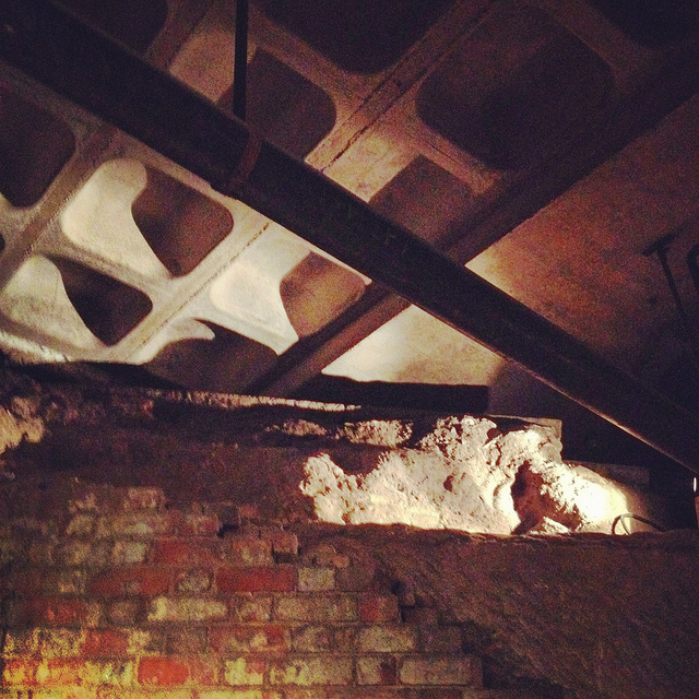
 [Images: Cave spaces beneath the Superstudio-like concrete grid of Nottingham’s Broad Marsh shopping Mall].
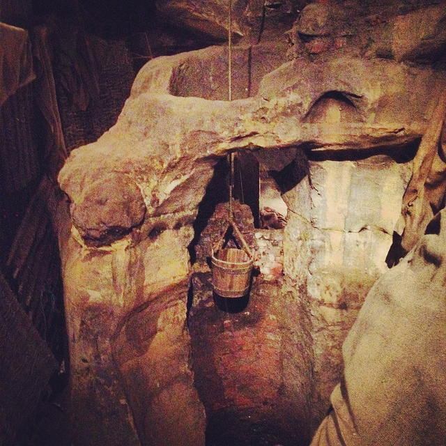 [Image: A well bucket in the caves beneath Broad Marsh; photo by BLDGBLOG].
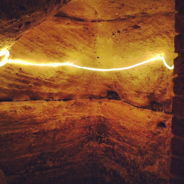
 [Images: Lines of lights we switched on in one of the off-limits rooms below Broad Marsh; photo by BLDGBLOG].
 [Image: A doorway to voids behind Broad Marsh Centre; photo by BLDGBLOG].
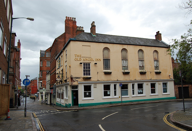
 [Images: The Old Angel Inn (top), including the door inside the pub that leads down to the caves below; photos by
 [Images: The caves of the Old Angel Inn, courtesy of the
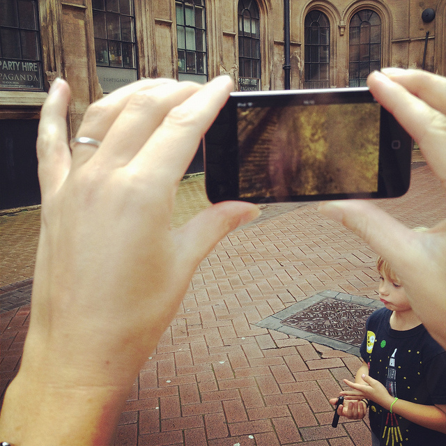
 [Images: We test-drive the cave-spotting app; bottom photo by
 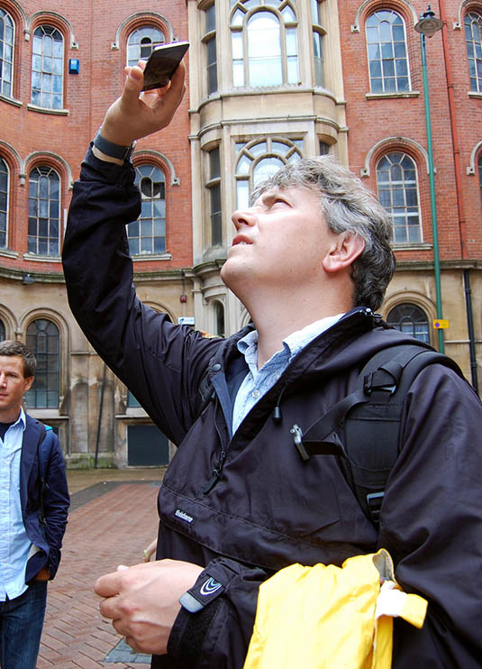 [Image: Mark Smout looks for caves in the sky; photo by
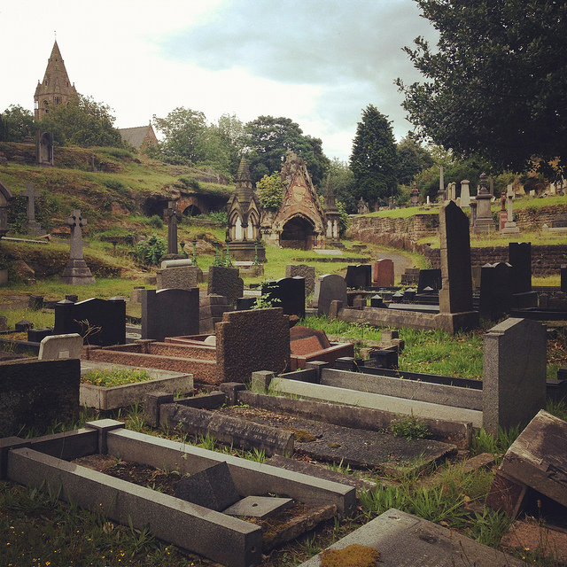
 [Images: Nottingham’s Rock Cemetery, where archaeologist David Strange-Walker explained the history of the local landscape].
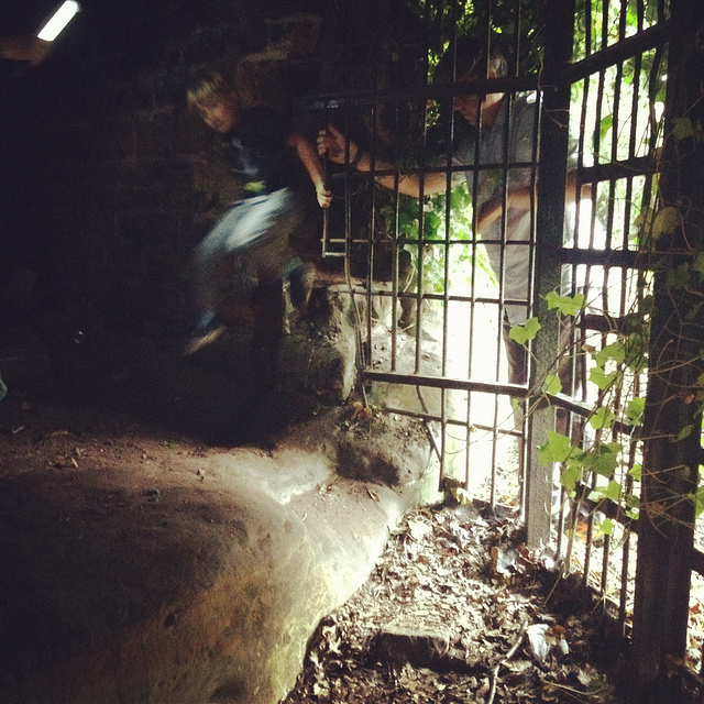
 [Images: The Rock Cemetery catacomb gates].
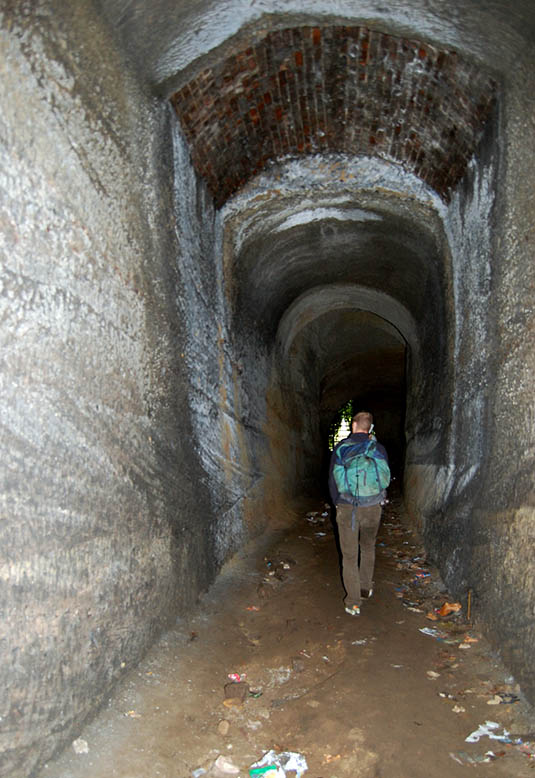 [Image: Inside the catacombs; photo by
  [Image: A door on the street—the black door with bars—leading down into a sand mine; photo by BLDGBLOG].
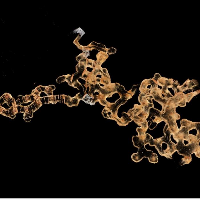
 [Image: The
 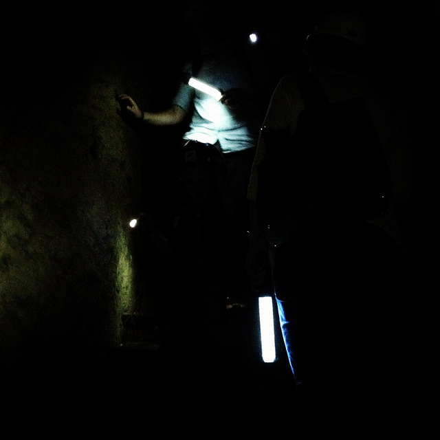 [Image: Nicola Twilley and Mark Smout head down into the sand mine; photo by BLDGBLOG].
 [Image: Many of these way-finding signs are actually incorrect, David explained, and seem to have been painted as a kind of sick joke by someone several years ago; photos by BLDGBLOG].
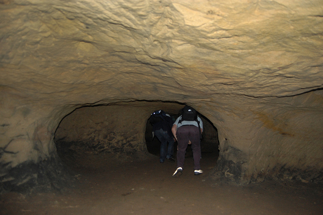
 [Images: Inside the sand mine; all photos by
  [Image: Mark & Ellis Smout explore our final “underground” space of the day, the magnificent Park Tunnel; the banded strata clearly visible in the walls show how the tunnel was carved through the dunes of an ancient desert. Photo by BLDGBLOG].