Katrina 3: Two Anti-Hurricane Projects (on landscape climatology)

Project 1: “How do you slow down a hurricane?”
In the June 2005 edition of The Economist Technology Quarterly (subscription required), we read about Moshe Alamaro, “a scientist at the Massachusetts Institute of Technology, [who] has a plan. Just as setting small, controlled fires can stop forest fires by robbing them of fuel, he proposes the creation of small, man-made tropical cyclones to cool the ocean and rob big, natural hurricanes of their source of energy. His scheme, devised with German and Russian weather scientists and presented at a weather-modification conference in April, involves a chain of offshore barges adorned with upward-facing jet engines.”


“Each barge creates an updraft, causing water to evaporate from the ocean’s surface and reducing its temperature. The resulting tropical storms travel towards the shore but dissipate harmlessly. Dr Alamaro reckons that protecting Central America and the southern United States from hurricanes would cost less than $1 billion a year. Most of the cost would be fuel: large jet engines, he observes, are abundant in the graveyards of American and Soviet long-range bombers.”
The creation of manmade tropical micro-storms, using heavy, greenhouse gas-burning jet engines towed through the waters of the equatorial Atlantic on what are, for all intents, artificial islands… is really a pretty ridiculous idea.
Yet it reminds me of a long-standing BLDGBLOG project that has otherwise gone unpublished. Till now:

Project 2: The Aeolian Reef
In Virgil’s *Aeneid*, translated by Robert Fitzgerald, we read about “Aeolia, the weather-breeding isle”:

“Here in a vast cavern King Aeolus
Rules the contending winds and moaning gales
As warden of their prison. Round the walls
They chafe and bluster underground. The din
Makes a great mountain murmur overhead.
High on a citadel enthroned,
Scepter in hand, he molifies their fury,
Else they might flay the sea and sweep away
Land masses and deep sky through empty air.
In fear of this, Jupiter hid them away
In caverns of black night. He set above them
Granite of high mountains – and a king
Empowered at command to rein them in
Or let them go.” (Book 1, Lines 75-89)

Thus: BLDGBLOG’s Aeolian Reef.
To be fair, this all began as nothing more than an idea for a new, artificial island that would be added to the Cyclades archipelago in Greece. It would be somewhere between Constant’s Babylonic mid-sea pavilion –


– an oil derrick –


– the Maunsell Towers


– and a kind of massive, off-shore, geotechnical saxophone.
Full of vaulted tubes and curved ampitheaters – and complex twists through a hollow, polished core – this modern Aeolia, an artificial island, would produce storms (and even, possibly, negate them).
A modern Aeolia, in other words, would be a “weather-breeding isle” – or a “weather-cancelling isle,” as the case may be: because then there was Katrina.
What would happen, I thought, if you built a manmade, weather-cancelling isle that could *stop hurricanes from forming*? I realized, of course, immediately, that you would actually need hundreds of these tuba-like, anti-hurricane islands – even an entire manmade archipelago of them – because the atmospheric paths of storms are far too unpredictable.
You would need, that is, an Aeolian Reef.
The Aeolian Reef – and the current author, who cannot draw, hint-hint, would *love* to collaborate with any BLDGBLOG readers who want to illustrate some of these things – would consist of oil derrick-like platform-islands built in climatologically influential patterns throughout both the Gulf of Mexico and the larger, equatorial Atlantic.
The Aeolian Reef would: 1) trap and redirect high-speed winds from any burgeoning tropical storms and hurricanes, thus preventing them from actually forming; 2) provide incredibly exciting meteorological/atmospheric observation platforms far out at sea; and 3) be readily exportable to other countries and other climates, for other purposes – land-based anti-tornado clusters, for instance.
This would therefore take the subject of an earlier BLDGBLOG post a few steps further: it would use architecture, or landscape architecture, as a way to directly influence, change, or redirect the climate.
It would, in short, be *landscape climatology*.
One could imagine alternative uses, of course; even a computer glitch or global supervillain who rearranges all the internal valves of the Aeolian Reef to generate the mother of all hurricanes… in which case the Reef would be something of a national security threat.

This thread continues in Katrina 1: Levee City (on military hydrology); and Katrina 2: New Atlantis (on flooded cities).

Katrina 2: New Atlantis (on flooded cities)

New Orleans is not the only city to be faced with a future of indefinite flooding – nor is it the only city in the world below sealevel.
The entire nation of the Netherlands, for instance, provides perhaps the most famous example of urbanized land reclaimed from the Atlantic seafloor. “Polders” is the Dutch name for such rigorously flood-controlled territory, and an exhibition literally even now being held at the Rotterdam-based Netherlands Architecture Institute explores the polders’ geotechnical creation.
The polders’ “rationally organized landscape is unique, but also vulnerable,” the NAI explains. Vulnerable to overdevelopment – as well as to catastrophic flooding.
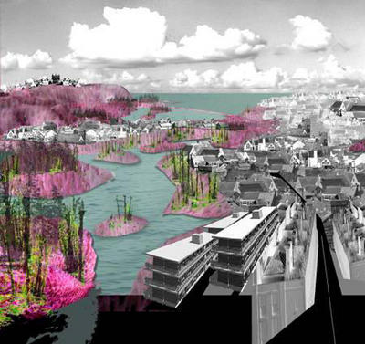
The 2005 Rotterdam International Architecture Biennale, in fact, takes nothing less than “The Flood” as its central, organizing theme – with one particular sub-focus being Water City*.


[Image: The metropolis, the flood, the boundaries of architectural design.]
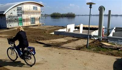
In April and May, 2005, The New Yorker ran a three-part article by Elizabeth Kolbert, called “The Climate of Man,” on the subject of human-induced climate change. The third part, published on 9 May 2005, ends with a description of how “one of the Netherlands’ largest construction firms, Dura Vermeer, [has] received permission to turn a former R.V. park into a development of ‘amphibious homes'” – a floating city. (The Guardian also has an article about this.)
“The amphibious homes all look alike,” Kolbert says. Floating on the River Meuse in Maasbommel, “they resemble a row of toasters. Each one is moored to a metal pole and sits on a set of hollow concrete pontoons. Assuming that all goes according to plan, when the Meuse floods the homes will bob up and then, when the water recedes, they will gently be deposited back on land. Dura Vermeer is also working to construct buoyant roads and floating greenhouses” – the entire human race gone hydroponic.
As Dura Vermeer’s environmental director says: “There is a flood market emerging.”


[Image: A floating house, moored to the earth, in Maasbommel.]
Further afield, the year 2005 has seen major flooding in Europe, India, and Bangladesh, to name but a few sites of major hydrological catastrophe.
In Mumbai, India, *The Economist* explains, the 2005 floods “uncovered long-term failures. Not enough had been done to maintain Mumbai’s ageing infrastructure, such as storm-drains and sewers. Worse, new building had weakened the city’s defences. Large areas of protective mangrove had been razed – in one notorious example, to make way for a golf course. Developers have built on wetlands, clogging natural drainage channels. River banks have been reclaimed and become slums.”


And then there is Bangladesh. “From the air,” we read, also in The Economist (most of their articles are for subscribers only, it’s really irritating), “Bangladesh looks less like a country than one vast lake, dotted with thousands of tiny islets, clumps of trees and houses. Few boats ruffle the placid floodwaters: there is nowhere to go.” And yet “[t]he great lake of Bangladesh is in reality a network of nearly 250 rivers.”
New Orleans, Rotterdam, Bangladesh, Mumbai: 2005 will be the year of flooded infrastructure and overwhelmed cities.
And so if Atlantis sets the gold standard for civilizations lost to floods – forget Noah – then it’s interesting that Atlantis, even before Katrina occurred, was back in the news this year (though I suppose it is every year). As already explored elsewhere on BLDGBLOG, Atlantis’s island home may (or may not) be in the Straits of Gibraltar.
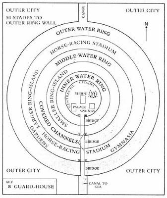
The real issue, however, that the infrastructural possibility of Atlantis brings to the fore – or, rather, that Katrina brings to the fore, through the hydrological destruction of New Orleans – is revealed quite clearly in the following artist’s representations of what Atlantis might have looked like:


Atlantis, city of dikes and levees, city of canals and inland seas, city of water-smart urban design and hydrological planning – it, too, was swallowed by the oceans, and destroyed.

This thread continues in Katrina 1: Levee City (on military hydrology); and Katrina 3: Two anti-hurricane projects (on landscape climatology) – both on BLDGBLOG.

Katrina 1: Levee City (on military hydrology)

[Policing the earth: a military helicopter surveys a flooded metropolis under martial law.]

It’s too easy, not to mention slightly vindictive, to blame all of hurricane Katrina’s catastrophic impact and aftermath on the Army Corps of Engineers; but it is worth remembering that New Orleans – in fact the near totality of the lower Mississippi delta – is a manmade landscape that has become, over the last century at least, something of a military artifact. To say that New Orleans is, today, under martial law, is therefore almost redundant: its very landscape, for at least the last century, has never been under anything *but* martial law. The lower Mississippi delta is literally nothing less than landscape design by army hydrologists.
New Orleans as military hydrology.
Or, military urbanism as a hydrological project.
According to The Economist, “For much of the 20th century the federal government tampered with the Mississippi, to help shipping and – ironically – prevent floods. In the process it destroyed some 1m acres of coastal marshland around New Orleans – something which suited property developers, but removed much of the city’s natural protection against flooding. The city’s system of levees, itself somewhat undermaintained, was not able to cope.”
When even people within the Army Corps of Engineers began to warn that the hubristic landscape design methods of the US military might actually be inappropriate for what is a very muscular, flood-prone, not-to-be-fucked-with drainage basin, the warnings were taken – well, frankly, they were probably taken to be blatantly unpatriotic, knowing what’s happened to this country. But I digress.
“There is an irony,” The Economist elsewhere continues, “in this warning coming from the Corps of Engineers. Just as with the Everglades in Florida, New Orleans’s vulnerability has been exacerbated by the corps’ excellence in reshaping nature’s waterways to suit mankind’s whims. In the middle of the last century, engineers succeeded in re-plumbing the great Mississippi… [which simply] hastened erosion of the coastal marshes that used to buffer New Orleans, leaving the city needlessly exposed. Most of the metropolitan area lies below sea level on drained swamp land. Levees normally hold back the Mississippi and Lake Pontchartrain, but those were not designed to handle the waters that would come with such a powerful hurricane.”
Those same levees, in fact, as we all know, are actually now responsible for keeping the flood waters in:


“‘We’ve been living in this bowl,’ said Shea Penland, a coastal geologist who has studied storm threats to Louisiana for years,” in an interview with The New York Times. “‘And then Katrina broke channels into the bowl and the bowl filled. And now the bowl is connected to the Gulf of Mexico. We are going to have to close those inlets and then pump it dry.'”
But pumping the flooded city dry will be a “hard task,” according to the somewhat characteristic understatement of the BBC, in an article that then outlines the various steps of the engineering strategy involved (included new causeways, steel sheets, and 300-lb. sandbags).
But even if New Orleans is “pumped dry,” even if the city is eventually drained, even if commerce returns and the Big Easy’s population goes back to life as usual, there is still a much larger problem to face.
The Economist: “America’s Geological Survey has estimated that if nothing is done by 2050, Louisiana will lose another 700 square miles of coastal wetlands. Various local groups have long called for reconstruction of the marshes along the lines of the troubled $10 billion Everglades rejuvenation project. The New Orleans version, which would cost $4 billion more, would divert some 200,000 cubic feet of water each second from the Mississippi 60 miles through a channel to feed the existing marsh and to build two new deltas. The plan, which would also shut canals and locks to keep out salt water and would build artificial barrier islands, may find more adherents.”
Artificial barrier islands; 200,000 cubic feet of water each second; two new deltas: if at first you don’t succeed… try ever more elaborate feats of hydrological engineering. More of the disease is the cure for the disease. (See here for a much older – yet no less impressive for being small-scale – example of complex hydrological engineering).
Katrina, in this context, becomes a problem of landscape design.
The “hurricane” as an atmospherically-interactive, military-hydrological landscape problem.

[NASA satellite image: the Mississippi delta – several hundred square miles smaller than it should be.]

It’s a question, in other words, of human geotechnical constructions and how they interact with the complex dynamics of the earth’s tropical atmosphere and waterways.


[Image: Nearly all of the Atlantic’s equatorial reserves of warm water contributed to the strength of the storm. A few levees didn’t stand a chance.]
So what may soon become known as the destruction of New Orleans was simply the violent and undeniable clarification of how bad certain examples of landscape architecture really can be. This should surprise no one – horrify everyone, but surprise no one.


[Images: The total collapse of the manmade landscape has all but drowned the city, turning it, in the words of the Associated Press, into “a ruined city awash in perhaps thousands of corpses, under siege from looters, and seething with anger and resentment”; and the complete failure of urban infrastructure – including federal emergency response, management, and planning, which has hamstrung itself by sending first-responders to fight in Iraq – has made what is fundamentally a problem of landscape design much worse.]

Financially, could things have been different? Could the money now being spent in Iraq and on bogus Homeland Security projects have gone elsewhere – into FEMA, for instance, or into hydrologically better-designed levee projects on the outskirts of New Orleans? Or into some of those “artificial barrier islands” mentioned above (that BLDGBLOG would love to help design)?
Yes, the money could have been spent differently. But is further entrenching a particular manmade landscape – really, a kind of prosthetic earth’s surface, a concrete shell, of valves, dams, locks, levees, and holding ponds installed upon the lower Mississippi – really the answer? Perhaps; but equally possible is that *there should not be a city there*.


As Mike Davis writes in *Dead Cities*: “Nature is constantly straining against its chains: probing for weak points, cracks, faults, even a speck of rust. The forces at its command are of course colossal as a hurricane and as invisible as a baccilli. At either end of the scale, natural energies are capable of opening breaches that can quickly unravel the cultural order. (…) Environmental control demands continuous investment and systematic maintenance: whether building a multi-billion-dollar flood control system or simply weeding the garden. It is an inevitably Sisyphean labor.”
Davis then describes the 19th century novel *After London: or, Wild England* by Richard Jefferies, a book in which “the medievalized landscape of postapocalyptic England” is explored “less [as] a nightmare than [as] a deep ecologist’s dreamwish of wild powers re-enthroned. (William Morris reported that ‘absurd hopes curled around my heart as I read it.’)”
After its destruction, then, this is London: “As fields, house sites, and roads were overrun, the saplings of new forests appeared. Elms, ashes, oaks, sycamores, and horse chestnuts thrived chaotically in the ruins while more disciplined copses of fir, beech, and nut trees relentlessly expanded their circumferences.”
The city is soon home to huge flocks of kestrel hawks and owls; wild cattle; and thousands and thousands of cats, “now mostly grayish and longer in body than domestic ancestors.” (As per the film *Logan’s Run* – or see CNN: “New Orleans residents who return to their homes [will] face ‘a wilderness’ without power and drinking water that will be infested with poisonous snakes and fire ants.”)
Eventually, Davis recounts, “new species or subspecies [evolve] out of other former domesticates, (…) [and] the monstrous vegetative powers of feral nature begin a full-scale assault on London’s brick, stone, and iron skeleton.”
“As marsh recovered the floodplain, (…) [t]he hydraulic pressure of the flooded substratum of the city – underground passages, sewers, cellars, and drains – soon burst the foundations of homes and buildings, which in turn crumbled into rubble heaps, further impeding drainage.”
A “200-mile-long inland sea” soon forms: “Jefferies’s extinct London, in short, is a giant stopped-up toilet, threatening death as an ‘inevitable fate’ to anyone foolish enough to expose themselves to its poisonous miasma.”
It becomes, that is, a flooded city.

[Image: A corpse floats in the oil-coated lake that was once New Orleans.]

This thread continues in Katrina 2: New Atlantis (on flooded cities); and Katrina 3: Two anti-hurricane projects (on landscape climatology) – both on BLDGBLOG.