Future Super-Cities

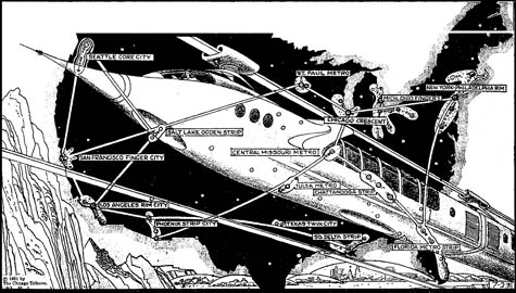
[Image: The Super-Metropolis of 1975, via Paleo-Future; view larger!].

Yesterday, Paleo-Future pointed out a map from 1961, produced by the Chicago Tribune, in which the future urban landscape of the U.S. has been speculatively mapped – as it was projected to exist in the bright and futuristic year of 1975.

Ahead of its time in predicting the urban condition within which most of us now live, the map and its accompanying short article suggest that the “‘regional cities’ of tomorrow will be nearly continuous complexes of homes, business centers, factories, shops and service places. Some will be strip or rim cities; some will be star-shaped or finger-shaped; others will be in concentric arcs or parallels; still others will be ‘satellite towns’ around a nucleus core.”

Unfortunately, it gets the future of U.S. transportation all wrong:

They will be saved from traffic self-suffocation by high-speed transportation – perhaps monorails that provide luxurious nonstop service between the inner centers of the supercities, as well as links between the super-metropolises themselves.

Having ridden Amtrak somewhat extensively up and down the east coast, I would respectfully suggest that a different infrastructural future has come to pass.

Meanwhile, if you look at a bigger version of the map, you’ll see cities like the Chicago Crescent, the Michigan-Ohio Fingers, and Los Angeles Rim City – but it’s the sprawling urban complexes at the core of the country that seem so strangely interesting to me, like the Chattanooga Strip and the Central Missouri Metro, all linked together by arteries of high-speed rail.

What might a futuristic super-city in the hills and valleys of Tennessee really look like? What might a Mississippi mega-city really be?

(Via Paleo-Future, on a tip from James Petty).

By Indirections, Find Directions Out

Last autumn, an article in New Scientist asked: “What routes did our ancestors take as they moved into lands unknown and traversed uncharted seas? When did they move and spread?”
The magazine thus included a two-page map – attempting to answer these larger cultural and evolutionary questions via cartography.

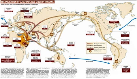
[Image: A map of possible human migration routes out of Africa and the Middle East; via New Scientist].

“Until quite recently,” the article tells us, “H. sapiens was thought to have evolved just 100,000 years ago. Over the past two decades, however, a consensus has grown that anatomically modern humans emerged in Africa at least 160,000, and possibly 200,000, years ago.”
But how did humans spread?

Skeletal remains from Skhul and Qafzeh in Israel dating from 120,000 to 90,000 years ago are the oldest known traces of modern humans outside Africa… However, all evidence of human habitation beyond Africa disappears around 90,000 years ago, only to emerge again much later.

What happened later is the subject of the article – which goes on to encompass “signature” mutations, southern routes and northern routes out of Africa, “the gene associated with language,” the colonization of Australia, bone-bearing caves on the coast of Sri Lanka, and so on.
Little details stand out. For instance: “The earliest evidence of settlement by modern humans in south Asia, comprises stone tools and human remains discovered in the Fa Hien and Batadomba Lena caves in Sri Lanka, dating from up to 35,000 years ago.”
However – and I find this absolutely fascinating: “Although none of these artefacts is more than 35,000 years old, that may simply reflect the fact that sea levels are about 100 metres higher today than they were 50,000 years ago. Any artefacts or bones left by the first coastal migrants are now buried beneath the sea.” (emphasis added)
But it’s the map, I think, that tells the story so clearly. My only major problem with it is that it shows the world as it looks today, with sea levels where they stand in the present.
However, as we only just read, global sea levels were at least 100 meters (or 328 feet) lower back then, because so much water had been frozen into continent-spanning glaciers. Accordingly, the continents would have had very different outlines. Sri Lanka was not an island, for instance, but a peninsula connected to India, and many, many hundreds of smaller islands throughout Indonesia were actually connected into one large landmass.

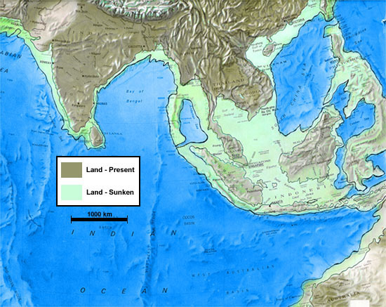
[Image: A map of southeast Asia during the Ice Age; note how much dry land there could have been. This certainly isn’t the greatest map in the world; it’s just all I could find – and it comes from a site claiming that this somehow proves Atlantis was real…].

Looking at a more accurate Ice Age geography, in other words, would make it substantially easier to comprehend how humans spread, for the most part on foot, to places as far away as central Australia. In fact, I’d go as far as to suggest that, until you look at the world as it was back then, with lower sea levels, you will only mis-theorize these migration routes, devising ever more elaborate forms of seafaring and stellar navigation when it might simply have been the case that they walked.
In any case, ancient human migrations just blow me away. What was it like, standing there on the sandy coasts of Iran or Saudi Arabia, 55,000 years ago? Walking around in the growing darkness as evening sets in, looking up at the stars, building fires – perhaps even dreaming of future towers on the very site where Dubai now rises.

[Note: If anyone knows where to find good maps of Ice Age coastlines, let me know!]

Neuro-Tourism

In J.G. Ballard’s otherwise unexceptional 1996 novel Cocaine Nights, we read about a Mediterranean resort called the Estella de Mar.

[Image: The Resort from the Ocean by buck82; note, however, that this particular resort is in Cuba].

The Estrella de Mar is situated along a moribund stretch of the Gibraltar coast, where “a sluggish sea lapped at the chocolate sand of the deserted beaches.”

The coastal strip was a nondescript plain of market gardens, tractor depots and villa projects. I passed a half-completed Aquapark, its excavated lakes like lunar craters, and a disused nightclub on an artificial hill, the domed roof resembling a small observatory.

A nearby town is described as being “without centre or suburbs.” In fact, it “seemed to be little more than a dispersal ground for golf courses and swimming pools.” The few humans who can still be seen in this oddly depopulated environment are out lying across old reclining chairs, barely talking to one another; but this is what happens, Ballard jokes, “when continuous sunlight is shone on the British.”

[Image: Photo by David Monniaux, via Wikipedia].

Into this world of automated tennis machines and monogrammed hotel ice buckets comes an English travel writer whose brother may or may not have committed a crime a few days earlier. We follow this outsider from the minute he arrives. He drives his rental car past “white-walled retirement complexes marooned like icebergs among the golf courses.”
He soon parks, gets out, and goes for an afternoon hike, unsure of the culture he’s now surveilling:

I climbed a pathway of blue tiles to a grass knoll and looked down on an endless terrain of picture windows, patios and miniature pools. Together they had a curiously calming effect, as if these residential compounds – British, Dutch and German – were a series of psychological pens that soothed and domesticated these émigré populations.

[Image: Architecture in the Costa del Sol as photographed by Q-BEE].

Ballard continues:

Already thinking of a travel article, I noted the features of this silent world: the memory-erasing white architecture; the enforced leisure that fossilized the nervous system; the almost Africanized aspect, but a North Africa invented by someone who had never visited the Maghreb; the apparent absence of any social structure; the timelessness of a world beyond boredom, with no past, no future and a diminishing present. Perhaps this was what a leisure-dominated future would resemble? Nothing could ever happen in this affectless realm, where entropic drift calmed the surfaces of a thousand swimming pools.

More to the point, however, and in a quotation which I’m having trouble locating, the novel briefly raises the question of whether it might be more appropriate to send not a travel writer but a psychologist to cover a new resort hotel – perhaps even a neuroscientist.
After all, this visitor would ask, taking notes for a kind of psycho-spatial analysis, what motivated the construction of such a place? Why would such a landscape – seemingly devoid of humans, animated only by pre-programmed swimming pool pumps – be constructed at all?
This globetrotting neuro-tourist then relays the research to Malcolm Gladwell or Jonah Lehrer, signing a contract for a brand new book. It becomes a bestseller. The Mind on Holiday, it might be called. Landscapes of Pleasurable Forgetting. The neuroscience of built space.
But it’s a serious question: could we learn more about, say, Dubai or Las Vegas – or Cancun – if we sent psychologists instead of travel writers?
Might there not be neurological reasons for the construction of certain buildings, or whole cities?
They check into vast air-conditioned lobbies, with no recognizable humans in sight. As dusk settles, they walk alone amidst well-fountained paths, surrounded by ferns, listening to Muzak on hidden speakers – and they produce uncannily accurate diagnoses of the psychological states of the architects and developers behind these non-places.
Then they turn their eyes on the other tourists…
So is this what travel literature right now is sorely missing: that we should be performing – and publishing – neuro-tourism?

(For a different kind of neuro-tourism, see io9).

Architecture and the Media

I’ve organized an event down in Los Angeles, coming up on Tuesday, April 15, for Dwell magazine. This is not a BLDGBLOG event, in other words, and I will only be moderating – but I would strongly encourage anyone in the L.A. area to come out.
It should be a fantastic evening, and I’m extremely proud of the line-up.

We’ve got Michael Govan, Director of the Los Angeles County Museum of Art; Frances Anderton, host of KCRW’s Design and Architecture radio show (DnA) and Los Angeles Editor of Dwell; and Christopher Hawthorne, architecture critic for the L.A. Times and easily one of the most interesting critics working in the field today.
The theme of the evening is “architecture and the media.”
How, for instance, does one discuss architecture over the radio – or in the newspaper, or in a gallery space? How are architectural ideas communicating through these various media? Does the medium itself inform the message, as it were – and in what specific way?
How are architecture and architectural ideas repackaged for discussion in these various forms?
For instance, as the New York Times reported last year, Govan hopes to engage on a curatorial project “to collect houses”:

His idea – one that has rarely, if ever, been tried on a large scale by a major museum – is to collect significant pieces of midcentury residential architecture, including houses by Rudolf M. Schindler, Richard Neutra, Frank Lloyd Wright and his son Lloyd Wright, and to treat them as both museum objects and as residences for curators.

Govan himself explains:

“It started with an effort to rethink the museum, looking at the resources that are both locally powerful and internationally relevant,” he said. “It’s clear that the most important architecture in Los Angeles is largely its domestic architecture. I’ve talked certainly to a number of people who have interesting architecture, and I’m beginning to talk to other people about raising funds to preserve these works.”

This would have the interesting effect of distributing the museum, so to speak, throughout the city; it would also be architectural history exhibiting itself in itself, collapsing the distinction between the exhibition space and what that space displays.
Now put this into the context of architecture as a radio conversation and architecture as a subject for newspaper editorials, and you’ve got three very different approaches to how the public can engage with or come to understand the built environment.
The event will be in my former hometown of Culver City, at the Museum of Design Art and Architecture – which is located here.
Doors open at 7:30pm, and the event itself begins at 8, lasting roughly one hour – followed by drinks and mingling.
Check out this website for more information about tickets and so on.

Also, this will only be the first of many such events: Dwell Conversations should be a really fun new series of talks, taking place in three cities over the next several months.

The mathematics of preservation and the future of urban ruins

[Image: The self-weaving complexity of I-95 and I-695, north of Baltimore].

For a variety of reasons, it seems worthwhile to do a kind of combined recap of my recent talks for the AIA in Baltimore and at the University of Pennsylvania. If you were present at either one of those events, then this should hopefully serve as a nice trip down memory lane; if you weren’t there, this should give at least some idea of the topics covered, themes discussed, images seen, and so on. Of course, if this sounds even remotely interesting, I’d be more than happy to give a similar talk at a venue near you… I’ve been having a blast doing these things.
In any case, I was in Baltimore two weeks ago on a joint invitation from the AIA and Preservation Maryland, to discuss architectural preservation, broadly conceived, with at least some relation to Baltimore proper.
So I began my lecture with a story from the science journals back in fall 2005. It turns out, we learned, that a specific highway junction north of Baltimore – where I-95 and I-695 meet – is topologically unique, exhibiting something called “non-trivial braiding.” However, because of that structure’s inefficiency as a traffic conveyor, the merging on- and off-ramps were going to be rebuilt, reconnected, and otherwise altered beyond mathematical recognition.
Its topology, in other words, would be ruined.

[Image: A diagram of the “non-trivial braiding” that awaits you on the eastern seaboard; via New Scientist].

A little bit of roadwork, and that mathematical object would be gone.
“I don’t want to encourage more cars onto the roads,” New Scientist wrote, “but if topology and beauty mean anything to you, get out there and enjoy I-95/695 now. It may soon be too late.”
So the question becomes: at what point do we preserve something not for its historical value but for its topological interest? If a bridge, or a highway overpass, becomes functionally obsolete, is it still subject to the rules of architectural preservation – whether or not it’s mathematically unique or culturally intriguing? Surely infrastructure is just infrastructure – i.e. when it breaks you replace it? You don’t preserve infrastructure.
Or do you?

[Images: Google Maps of the famed intersection].

Meanwhile, at what point does the exchange value of culture and history trump the use value of function and design?
And should mathematicians have any say?

[Image: Knot diagrams by Robert Scharein. Could we treat these as infrastructural blueprints and redesign the U.S. highway system to form a catalog of complex knots? You could then study experiential mathematics from behind the wheel of your car…].

Perhaps there’s a middle ground here. Perhaps we can, in fact, preserve something like a highway traffic exchange without forcing people to use its outdated twists and turns.
This brings us to the idea of the stabilized ruin.
If we could remove the intersection, for instance, from everyday use and simply build around it, we could then stabilize it as a ruin – turning it into a kind of abstract sculptural form, like something by Barbara Hepworth – and, at the very least, create an interesting site for mathematically inclined tourists.

[Images: Three sculptures by Barbara Hepworth – build these big enough and they’d be pieces of urban infrastructure].

For visual reference here I mentioned architect Alberto Campo Baeza‘s 2002 proposal for a Mercedes Benz Museum. Might Campo Baeza’s structure be a model for what the I-95/695 intersection would look like if it was detached from the highway system and left alone, to be surrounded by new freeways?
It’d be a kind of modern-day Stonehenge, made from on-ramps, surrounded by wildflowers, with well-designed signs to explain its fine geometry. Loops of concrete in space.

[Images: Proposal for a Mercedes Benz Museum by Alberto Campo Baeza].

Of course, there are other stabilized ruins – and here, trying to keep things regional, I pointed out Philadelphia’s Eastern State Penitentiary, highlighting photographs taken there by Shaun O’Boyle. We see some examples of O’Boyle’s work here in this post – and O’Boyle, of course, was featured in BLDGBLOG’s earlier look at Bannerman’s Island.
“After 142 years of consecutive use,” the penitentiary’s website explains, “Eastern State Penitentiary was completely abandoned in 1971, and now stands, a lost world of crumbling cell blocks and empty guard towers.” It was one of the only two U.S. sites that Charles Dickens went out of his way to visit, on a trip in 1842; the other was Niagara Falls.

[Images: Four photos of Eastern State Penitentiary, taken by Shaun O’Boyle].

So if stabilization is a viable preservation strategy, then what are its limits? What is too small to worry about – and what is too large even to consider?
Back in the late 1990s, photographer and urban sociologist Camilo José Vergara controversially proposed that a “skyscraper ruins park” be built in downtown Detroit. In his book American Ruins, Vergara suggested that, “as a tonic for our imagination, as a call for renewal, as a place within our national memory, a dozen city blocks of pre-Depression skyscrapers be stabilized and left standing as ruins: an American Acropolis.”
Continuing this line of thought in a later article for Metropolis, Vergara wrote:

We could transform the nearly 100 troubled building into a grand national historic park of play and wonder, an urban Monument Valley… Midwestern prairie would be allowed to invade from the north. Trees, vines, and wildflowers would grow on roofs and out of windows; goats and wild animals – squirrels, possum, bats, owls, ravens, snakes and insects – would live in the empty behemoths, adding their call, hoots and screeches to the smell of rotten leaves and animal droppings.

Of course, fantasies of ruined cities are alive and well, so to speak. One need only look as far as the disastrous film I Am Legend, or turn to Alan Wiseman’s recent bestseller The World Without Us to see that the appeal of dead cities never quite fades.

[Image: A poster for I Am Legend].

Indeed, I’m tempted here to pitch a new breed of entertainment complex to some oil-rich emir or investment group: the idea is that you would build a ruined city on the shores of an artificial island somewhere south of all the luxury developments in Dubai, and you’d invite tourists to explore those haunted canyons of steel and broken glass.
For the low-low price of only $75,000 a day, you can rent the entire park for yourself – and thus be Will Smith for a day, wandering through ruined department stores and sunbathing in weed-filled plazas.
At the very least, imagine the political implications of such a park: touring the ruins of the west by visiting Dubai – where the shattered remnants of Euro-America are nothing but a theme park for global tourists.
With recognizable buildings from London, New York, Chicago, Paris, Rome, and so on, I suppose it’d be a little like the film Resident Evil: Extinction, where we see the lost lights of Las Vegas buried in desert sand.
Only here it’s a simulacrum of the entire western world, and it’s laid out as waste at the feet of Dubai’s glass towers and air-conditioned boulevards.

[Image: A poster for Resident Evil: Extinction].

In any case, with accidentally good timing, we moved on from there into a discussion of architect Albert Speer’s notorious plans for the Nazi super-city of Germania: a vision of what Berlin would become, given the presumed global triumph of Hitler and his skeletal empire. Of course, Speer’s by now well-known architectural theory was that all buildings should be designed so that they will look good in the future as ruins.
He called this ruin value.
I say “good timing” here, because Germania is actually the focus of a well-publicized exhibition in Berlin, going on right now, called Myth Germania. It comes complete with a detailed model of Speer’s urban vision – bits of which can be seen here in old photographs.

[Images: Albert Speer’s Germania].

Although ruined cities appear again and again here on BLDGBLOG – and will continue to do so – there is a stage beyond ruin, something that comes after dereliction and abandonment. As long as we are willing to think along geological timescales, in other words, then we can talk about what I’ve called urban fossil value.
What will our cities look like when they have fossilized?
Who else but New Scientist approached this very topic nearly a decade ago, explaining that, hundreds of millions of years from now, many of our cities will indeed become fossils.
These fossil cities will be “a lot more robust than [fossils] of the dinosaurs,” geologists Jan Zalasiewicz and Kim Freedman wrote, and those fossils will consist of “the abandoned foundations, subways, roads, and pipelines of our ever more extensive urban stratum” – becoming “future trace fossils” of a lost form of life.
The already subterranean undersides of our modern cities, from Tube tunnels to secret government bunkers, “will be hard to obliterate. They will be altered, to be sure, and it is fascinating to speculate about what will happen to our very own addition to nature’s store of rocks and minerals, given a hundred million years, a little heat, some pressure (the weight of a kilometer or two of overlying sediment) and the catalytic, corrosive effect of the underground fluids in which all of these structures will be bathed.”
Plastics, for instance, “might behave like some of the long-chain organic molecules in fossil plant twigs and branches, or the collagen in the fossilized skeletons of some marine invertebrates.” A hundred thousand Evian bottles, then, might someday be transformed by compression into a new quartz: vast and subterranean veins of mineralized plastic.
Of course, all of this depends on the future tectonic fates of certain regions. Los Angeles, for instance, “is on an upward trajectory,” the geologists explain, “pushed by pressure from the adjacent San Andreas Fault system,” and so it is “doomed to be eroded away entirely.” But if a city is flooded, buried in sand, or otherwise absorbed downward, then “the stage is set to produce ideal pickling jars for cities. The urban strata of Amsterdam, New Orleans, Cairo and Venice could be buried wholesale – providing, that is, they can get over one more hurdle: the destructive power of the sea.”

[Images: Fossils, via the Fossil Museum].

Rather than talk about ruin value, then, which is so Romantically 18th century, why not strive for fossil value instead? Tens of millions of years in the future, when all of this urban infrastructure has turned to sludge, and radiative terrestrial heat has cooked old bricks into something resembling trace fossils, our cities could still be beautiful.
Can we design for this fate? Can we plan urban fossils ahead of time?
Can we give our constructions urban fossil value?

Transmitting live from below the Antarctic Ice

[Image: Antarctica by Christopher Michel].

I’ve written about the sounds of Antarctica before, but, as it happens, we can now listen directly to “an acoustic live stream of the Antarctic underwater soundscape.”
This “live stream” is recorded via hydrophones attached to “an autonomous, wind and solar powered observatory located on the Ekström ice shelf.” The observatory is called PALAOA – the PerenniAL Acoustic Observatory in the Antarctic Ocean – and its purpose is “to record the underwater soundscape in the vicinity of the shelf ice edge over the duration of several years.”
Bizarrely, the Institute reminds us that “this transmission is not meant for entertainment” – it is meant “for scientific research.” Twenty-five people sitting around in a Manhattan apartment, popping open some more wine at 2am, listening to the sounds of Antarctica. Or next year’s Super Bowl half-time show: an acoustic live stream of the Antarctic underwater soundscape.
Adrenalin goes through the roof.

(Via del.icio.us/kio).

The Sound of Evolution

[Image: Istanbul Birds in Flight by Tim O’Brien].

City birds have begun to sing new songs. “Gone is the familiar dawn chorus, with its rich mix of enchanting melodies and calls,” New Scientist writes. “In its place is a strangely depleted music – abrupt, high-pitched and sometimes ear-piercing.”
It seems that constant background sound in cities is having an alarming effect on bird species.

Some species simply are not able to make themselves heard above the ever-growing racket and are finding themselves squeezed out of the city. Others are beginning to change the way they communicate. In the long term, new species may evolve. If noise levels continue to rise, it seems inevitable that urban bird life will change dramatically.

Birds such as house finches, blackbirds, and – yes – great tits are learning how to adapt.
Researchers found that great tits in the city, for instance, will actually sing “higher-pitched tunes than their forest-dwelling counterpart” – indeed, that city tits even tune in to different noises now because they’re drowned out at other frequencies.

[Image: Bird subcommittee on traffic by Rosanne Haaland].

This, too, could have huge implications.

If singing and hearing diverge enough, urban birds may be less likely to find the vocals of rural birds attractive, or even to recognise them as members of the same species. These changes could serve to eventually split populations into genetically distinct urban and rural species. Alternatively, different populations of the same species might adopt differing strategies to cope with urban noise, leading eventually to a species split occurring in birds living in the same neighbourhood.

Roads and other forms of transport infrastructure – such as airports – are a major part of the problem. In Holland, we read, “the construction of a road near a particular [warbler nest] reduced the number of warbler breeding pairs from around 10 to just two. When the road was closed for repairs for two years, five more pairs moved into the area, although the subsequent return of traffic drove them away again.”
Everyone, and everything, is just looking for some peace and quiet.
I’m reminded of something I’ve written for a future issue of Dwell about the role of urban sound control in massive eco-design schemes – but I’ll leave that unexplored till the (albeit very brief) article comes out.

Forgotten Architects

[Image: A spread from Pentagram Papers 37: Forgotten Architects].

Earlier this month, Pentagram released a pamphlet called Pentagram Papers 37: Forgotten Architects.

In the 1920s and early 1930s, German Jewish architects created some of the greatest modern buildings in Germany, mainly in the capital Berlin. A law issued by the newly elected German National Socialist Government in 1933 banned all of them from practicing architecture in Germany. In the years after 1933, many of them managed to emigrate, while many others were deported or killed under Hitler’s regime. Pentagram Papers 37: Forgotten Architects is a survey of 43 of these architects and their groundbreaking work.

The work thus presented is based on research performed by Myra Warhaftig, and it is available both online and in a small, beautifully designed booklet. Four of the images you see here are spreads from that publication, courtesy of Pentagram.

[Image: Spreads from Pentagram Papers 37: Forgotten Architects].

As Warhaftig wrote in an introduction to the project:

On 1 November 1933, a few months after the German National Socialist Government came to power, a decree was issued banning Jewish architects from the Reichskulturkammer für bildende Künste, the state-governed association of fine art to which membership was required to practice architecture. Their academic titles were revoked and they were denied the use of the professional title “architect.” Just short of two years later, on 15 September 1935, another law was adopted, further excluding from the association all so-called Half-Jews and those who were married to Jews. In total, nearly 500 architects were affected by the ban and forced to leave Germany. Those who stayed had to go into hiding or were deported to ghettos or concentration camps.

[Image: A spread from Pentagram Papers 37: Forgotten Architects].

She continues:

After long and circuitous routes, I have succeeded in locating relatives of the deceased architects. Scattered across all continents, they were able to offer additional authentic material. These historical documents and biographies, as well as photographs of the architects’ buildings, are published for the first time in my book German Jewish Architects Before and After 1933: The Lexicon.

Many of the buildings these architects produced were absolutely extraordinary – and, frankly, it seems impossible not to look at these images and judge 20th century Germany in light of the catastrophic stupidities that led to its murderous exile of the creative classes, whether those were physicists, novelists, abstract expressionists, or even architect members of the Bauhaus.
Indeed, it’s impossible to look at today’s European landscape in general and not spot absences, or losses, voids here and there punctuating the 21st century town and city.

[Image: Tietz Department Store in Solingen (1930?), designed by Georg Falck; photo via Archive Dr. Hagspiegel].

The images here show some of the buildings that Myra Warhaftig’s research, performed up until her death only three weeks ago, uncovered. Many more shots are available on Pentagram’s project website.

[Images: Showcase House, Werkbundsiedlung Breslow, by Moritz Hadda (1929); Terraced Houses, Berlin, by Alfons Anker (1929-30); Arnold Zweig Residence (1929-30), Eisner Residence (1927), and Schulze Residence (1928-29), all in Berlin and all magnificent designs by architect Harry Rosenthal; and a police station in Berlin by Richard Scheibner (1930-31)].

Referring to the architects whose work is featured in the above seven photographs:
In 1933, Georg Falck fled with his family to the Netherlands: “In Amsterdam they survived in hiding until the end of the war. Falck died in a New York Hospital in May 1947, just six weeks after he and his family had emigrated to the USA.”
Alfons Anker‘s business partners joined the Nazi party in 1933; six years later, he “managed to flee to Sweden, but never succeeded in re-establishing his career as an architect. Anker died in Stockholm in 1958.”
Harry Rosenthal, architect of three houses featured above, “was born in Posen (today Poznan, Poland) in 1892. He lived and worked in Berlin where he ran a successful architectural practice. In 1933 he managed to flee to Palestine, but suffered from the subtropical climate. In 1938 he emigrated to England, where despite numerous attempts, he did not manage to re-establish his architectural career. He died in London in 1966.”
In 1941, Moritz Hadda “was deported to an unknown location.”
Richard Scheibner‘s “fate is unknown.”

(Thanks to Michael Bierut and Kurt Koepfle at Pentagram for sending the booklet and spreads).

Earth Evolves

I’ve been looking at Ron Blakey‘s maps of the tectonic evolution of the earth’s surface again, and I just absolutely love these things.

[Image: The earth 600 million years ago, in the late Precambrian Era; mapped by Ron Blakey].

In fact, I think Blakey should be given some sort of science prize for putting these together; these help to visualize broad historical processes in a way that is visually clear, conceptually unforgettable, and imaginatively provocative, to say the least. And these images, posted here, are only one series among many that Blakey’s assembled – and these aren’t even all the images in that series. For that, you’ll have to visit Blakey’s site.
So what you’re looking at here is continental drift over a period of 600 million years, beginning with the Late Precambrian Era, above, through to the present day, in the penultimate image, below.

[Images: The tectonic paleo-history of the earth; mapped by Ron Blakey].

That sequence of four images, above, gives us the earth as a kind of northward spray of island arcs and micro-continents, small landmasses moving toward evolutionary isolation.
What must it have been like, I wonder, if we could somehow have taken a sailboat in and around those tropical seas, weaving through vast semicircular island chains, finding reefs and bays, lagoons and inlets, anchoring offshore and camping on the beaches of an absolutely dark earth, electricity-less and lit from above by stars – with all the constellations different back then, as even the galaxy itself is still unfolding, full of alien patterns in the sky.

[Images: The tectonic paleo-history of the earth; in the last two images, you can see recognizable landmasses just beginning to form. Maps by Ron Blakey].

Something else that fascinates me – and you can see this in the next three images – is the fact that, until relatively recently, Europe was actually an Indonesia-like archipelago, distributed throughout warm northern latitude waters. One of the residues of this geography is a massive fossilized reef that I wrote about here on BLDGBLOG almost exactly two years ago.
Referring to that reef in an article from 1991, New Scientist wrote that, “if we could travel 160 million years back in time,” we would find a reef “that occupied most of what is now Europe.”

At first sight this reef and its communities have striking similarities to the Great Barrier Reef. But this ancient reef structure is unique; its main architects were not corals, but multicellular marine sponges, many of which have no match today. And this reef was even bigger than the Great Barrier Reef. Its fossil remains stretch about 2900 kilometeres from southern Spain to eastern Romania, making it one of the largest living structures ever to have existed on Earth.

If you look at the following three images, then, you’ll see how and where “one of the largest living structures ever to have existed on Earth” was able to form.

[Images: The earth from roughly 150 million years ago to 50 million years ago; mapped by Ron Blakey].

Then, of course, we hit the present day – pictured below.
Suddenly this arrangement looks rather impermanent.

[Image: The earth in its present continental configuration; mapped by Ron Blakey].

It’s extraordinary to realize, then, that this sequence of images represents only 600 million years of geological time – because the earth has something like seven and a half billion years to go before solar extinction. And though plate tectonics may actually cease someday, let’s say that a healthy billion and a half more years of continental rearrangement are still in store for this world; what fantastic inland seas and archipelagos might yet be waiting to form?
Extrapolating from these very images into the future, as our planet continues to delink and spread, maneuvering its surfaces around in endless reconfigurations, is a time-consuming but worthwhile thought experiment; if we could get Blakey to speculate upon the tectonic future of the earth, for instance, that would indeed be something to see.
Of course, this is something that New Scientist actually wrote about this past winter, suggesting three possible evolutionary scenarios for where these nomadic fragments of our planet’s surface might end up:

Geologists now suspect that the movements of the Earth’s continents are cyclical, and that every 500 to 700 million years they clump together. Unfolding over a period three times as long as it takes our solar system to orbit the centre of the galaxy, this is one of nature’s grandest patterns. So what drives this cycle, and what will life be like next time the continents meet?

The article then gives us the hypothetical outlines of three possible supercontinents.

[Image: Three possible supercontinents, as mapped by New Scientist: Novopangaea, Amasia, and Pangaea Proxima; view larger].

As if these things are a matter of preference, let me absurdly point out that I am actually not a big fan of supercontinents; I think they’re boring. Luckily, they seem to crack apart based upon their own weight and bulk; in other words, like many Americans, supercontinents are too heavy for their own good.
Personally, I like archipelagos and island arcs.
In fact, might there be some way to hack the earth’s surface and ensure a supercontinent-free planet to come? We could somehow help certain portions of the earth’s surface to unzip, forming new island chains, and we could perforate continental shields the world over to assist with their future fragmentation…
In any case, what’s also interesting about these maps is that, taken as a whole, the last 600 million years appear really to have been a kind of mass northward migration of landmasses, as if the continents were pulled from one pole to the other by temporary, if monumental, spreading and subduction zones.
Again, though, these are not all the images in the series; for that, you’ll have to check out Ron Blakey’s website. And, seriously, someone needs to give this guy a fellowship or an award or something – these maps are just fantastic.

[Image: These images are also available in a small Flickr set].

Power Plant

Passing electricity through soil, and into the roots of plants, might stimulate the accelerated production of certain chemicals, New Scientist reports.

“The roots of garden pea plants were exposed to low-level electric current and subsequently produced 13 times more pisatin, an antifungal chemical, than plants that were not exposed to electricity,” we read. The specific experiment on which this claim is based involved applying “a 30 to 100 milliamp current to the growth-medium of plants grown hydroponically, or, in the case of barrel medic, to the solution surrounding the cell cultures.”
So is this the future of gardening? Growing hydroponic plants in an electrically charged, semi-liquid matrix in order to “stimulate” the production of new forms and compounds? You could perhaps plant star anise in vast, swampy test plots surrounded by High Voltage signs, and thus derive new anti-flu drugs from electrically active roots. Or generate new orchids, supersymmetrical and glowing, plugged directly into an electrical earth. The Philadelphia Flower Show will never be the same.
Or plug gardens like this into a solar power plant out in the desert somewhere – and a weird new form of exponential photosynthesis is born.

Google Maps of Sci-Fi

I’ve got a new post up on io9 this afternoon, and it might be of interest to readers here.
That post asks: Can fictional sites and spaces – in particular, things taken from science fiction – be included in online map sets, and what might the implications be? You look up “New York state” on Google Maps, but it includes a new layer of information: the routes and locations traveled by characters in Steven Spielberg’s War of the Worlds. Or you go to London only to find that the dashboard navigation system in your car includes all the major locations from The Day of the Triffids. In other words, if we can map science fiction into our cities, using online tools, how might that affect our experience of urban space?
These and other questions all pop up in Google Maps of Sci-Fi. Let me know what you think.