On Monday, November 24, I’ll be hosting a live interview at the Barbican in London with director Michael Winterbottom, for a special screening of his film Code 46. You can read a bit more about the event – as well as buy tickets – here.
This is part of an ongoing series called Architecture on Film, curated by the Architecture Foundation.
 [Image: From Michael Winterbottom’s Code 46, courtesy of United Artists].
The purpose of the event is to talk about film and architecture – or, in this case, cities, urban design, memory, science fiction, landscape, globalization, and the built environment. As you can see from the list of locations used for the film’s production, Code 46 is very well-traveled, stitching together urban – and exurban – environments from London, Shanghai, Dubai, Hong Kong, and even the deserts of Rajasthan.
That the film achieves the feel of science fiction simply through a well-edited depiction of existing landscapes says as much about the film as it does about the nature of city-building today; perhaps one might only half-jokingly suggest that people build cities today in order to live inside science fiction films.
 [Image: Shanghai, from Code 46, directed by Michael Winterbottom, courtesy of United Artists].
As BLDGBLOG explored the other week in a long post, “cities today are well known for popping up in the middle of nowhere, history-less and incomprehensible.”
That’s what cities now do. If these cities are here today, they weren’t five years ago; if they’re not here now, they will be soon. Today’s cities are made up, viral, fungal, unexpected. Like well-lit film sets in the distance, staged amidst mudflats, reflecting themselves in the still waters of inland reservoirs, today’s cities simply arrive, without reservations; they are not so much invited as they are impossible to turn away. Cities now erupt and linger; they are both too early and far too late. Cities move in, take root and expand, whole neighborhoods throwing themselves together in convulsions of glass and steel.
What does it mean, then, to set a film inside a mix of such spaces? And as more and more instant cities appear in the world, built from zero in less than a decade, how can cinema capitalize on the lack of recognition these historically too-new and culturally all but anonymous environments inspire?
What does it mean, as well, that the depiction of the future in Code 46 – a depiction of the future through architecture – involves no U.S. cities at all and only very brief glimpses of urban infrastructure in Europe?
 [Image: Shanghai, from Code 46, directed by Michael Winterbottom, courtesy of United Artists].
This brings up one of the more interesting aspects of the film – something not internal to it, but created by the current state of global urbanization. The film makes it deliberately unclear, in other words, that it was shot in multiple locations at all; the opening sequence blurs together landscapes, buildings, and infrastructures from very different cities – yet this unfamiliar new place to which we’re being introduced might very well exist.
For all many viewers know, perhaps Shanghai really is in the middle of a desert; perhaps Dubai really does look exactly like Hong Kong.
This confusion only seems possible, however, within a very narrow window of historical time. As the skylines and iconic hotel interiors of Dubai, Shanghai, Hong Kong, and elsewhere become visually familiar to many more people, it will become much harder to do what Code 46 has done – which is to edit them all up into a convincing pastiche. They are a spatial collage, an urban cut-up – William S. Burroughs as architectural director.
In ten years, then, would this be akin to cutting from a shot of the Empire State Building to a shot of the Eiffel Tower and pretending that these landmarks are in the same city – only to find that almost no one has been genuinely tricked?
In a funny but negative Amazon review of the film, a disappointed viewer actually mocks this very aspect: “If I have to keep seeing these movies with the I haven’t a clue which Metro I’m in look I’m going to scream.”
But what does it mean that Asian cities – cinematically depicted as a kind of monolithic urban Other – are, for the time being, so visually unfamiliar to Western audiences that they can be edited into a seamless Global Metropolis, a vast agglomeration of spatial alterity that we can cut-and-paste together on film?
Where might Code 46 have been made if it had been produced fifteen years from now? What explosive urban outgrowths between now and then will be sufficiently unfamiliar to literally hundreds of thousands of filmgoers that they could be combined into one convincing location?
Will the sci-fi films of tomorrow be set in Lagos, Delhi, Rabat, or Shenzhen? All of the above?
It’s the future science fiction of global third-tier urbanism.
For instance, one of the most striking aspects of the urban environment in The Matrix came simply from the fact that many – though not all – of the outdoor scenes were shot in Sydney, a city with which most American viewers are not visually familiar. The urban world of the Matrix thus took on an uncanny sense of near-resemblance, looking an awful lot like a city everyone has seen before – is that Houston? Tampa Bay? Fresno? – but not enough like any single one of them to be clear.
The film Primer, shot in Dallas, is an amazing example of this: the whole time you’re watching it you have no idea where you are… though absolutely everything about it looks familiar.
The effect, particularly in Code 46, is almost literally uncanny.
 [Image: The Shanghai skyline, from Code 46, directed by Michael Winterbottom, courtesy of United Artists].
Briefly, I’m also reminded here of Tativille, the massive film-set city built by Jacques Tati to produce his own film Playtime. Constructed solely for the purpose of hosting camera crews – and later disassembled – Tativille was a city of the image, its design shaped only by how it would look on screen. With Tativille in mind, what might future audiences think if, say, Dubai really does run out of money in the global economic downturn, its towers abandoned and eroding back to sand? It will be visible in films like Code 46 – but nowhere else. It will have ceased to exist.
It will have been a kind of Tativille of the Emirates, built only to host film crews and car commercials.
In any case, the film’s visions of desert poverty – scenes in Rajasthan – and desert opulence – scenes in Dubai – bring up the topic of uneven development. If, as William Gibson‘s oft-quoted line goes, the future is already here, it’s just unevenly distributed, then this also appears to be true in the context of architectural form and urban landscapes.
But which one is the future: the nationless desert of rights-deprived exiles or the golf course-filled desert of the stateless business class?
Or are these perhaps one and the same, requiring each other as the flipsides of their own formation?
 [Image: The opening titles of Michael Winterbottom’s Code 46, courtesy of United Artists].
None of these questions are new, of course, going back in some form or another to Sergei Eisenstein, Fredric Jameson, and many, many others; but the opportunity to discuss all this with Michael Winterbottom himself in reference to a specific – and, as it happens, visually stunning – film, in a monumental and legendary architectural complex like the Barbican, is something of which I’m genuinely excited to be a part.
So if you’re in London on Monday, November 24, consider stopping by. Tickets can be purchased directly through the Barbican’s website, and you can learn a bit more about the film here.
 The theme for the day is Design Process Innovation, and my own talk is called “San Francisco As It Should Be” – applying many of the ideas that have been found here on BLDGBLOG over the past few years to the (ironically complacent) city where I now live. From tectonic self-engineering to whole-city sound design, via guerrilla gardening, subterranean mobile libraries, and vertical film clouds, among many other ideas and projects, from Fritz Haeg to Sarah Ross to Steve Lambert and Packard Jennings, I’ll be taking a look at a range of ways to alter the face and experience of the city.
  [Image: The
  [Image: The
 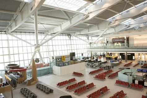 [Image: Heathrow Terminal 5, via
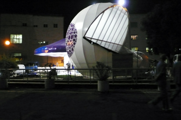
  [Image: The Waiting Room, Rome, by Jeffrey Inaba/
 [Images: The Waiting Room, Rome, by Jeffrey Inaba/


 [Images: The Waiting Room, Rome, by Jeffrey Inaba/


 [Images: The Waiting Room, Rome, by Jeffrey Inaba/
 [Image: The Waiting Room, Rome, by Jeffrey Inaba/
 [Image: A diagram of the
  [Image: From
  [Image: A screen-grab of the
  [Image: From the
  [Image: From the
  I’ll be teaming up with
  Some of the basic themes we should be approaching: If a growing majority of the human population has now been urbanized, moving into what are often incorrectly described as “cities,” what will warfare mean – and how will it be practiced – in these increasingly complex spatial environments? If urban insurgency is, indeed, the future of the global battlefield, as many theorists have proposed, how does the changing nature of urbanism itself help to redefine war? Conversely, how does insurrection work to redefine the space of the modern city?
  [Image: Photo by
  [Image: Photo by
  [Image: Photo by
 [Images: Photos by
 [Images: Photos by
  [Image: Photo by