New World Order

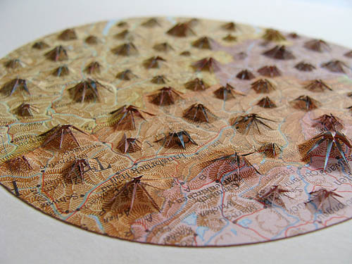
[Image: Work by Shannon Rankin, taken from the artist’s Flickr page].

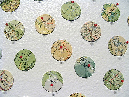
Artist Shannon Rankin does amazing things with maps. Treating them as mere pieces of decorated paper to be manipulated—clipping out spirals, folding crevassed roses of ridges and faultlines, pinning up confetti-like clouds of circles and zigzags—she creates “new geographies, suggesting the potential for a broader landscape.”

[Image: Work by Shannon Rankin, taken from the artist’s Flickr page].

The maps thus become more like the terrains they originally referred to: textured, complex, and subject to eruption. Unexpected forms emerge from below—like geology, overlapping, igneous, and dynamic.

[Images: Shannon Rankin, taken from the artist’s Flickr page].

Outlines of new island continents appear in the process, polar regions and archipelagoes that out-Dymaxion Buckminster Fuller in their collaged vortices and coasts.

[Image: By Shannon Rankin, taken from the artist’s Flickr page].

All of the works you see here come from Rankin’s Flickr page—specifically, the Uncharted, Bayside, ETA6, Maps, and Aggregate sets, where there are many other images to see.

[Images: All works by Shannon Rankin, taken from the artist’s Flickr page].

But seeing these makes me want to feed full-color sheets of obscure maps through laser-cutting machines, slicing elaborate and random geometries to reveal the longest possible distance between two adjacent things, or to discover previously unknown proximities, the whole Earth cut-up and unspooled like a lemon rind.

[Image: By Shannon Rankin, taken from the artist’s Flickr page].

There are a variety of distinct styles at work, as you can see, from tiling and tesselation to straight-ahead origami.

[Images: All works by Shannon Rankin, taken from the artist’s Flickr page].

Another approach is to reduce every map to capillaries—pure roads. The geography is simply how you get somewhere.

[Image: Work by Shannon Rankin, taken from the artist’s Flickr page].

And lest all of these look diminutive, or simply too tiny to see, the scale of execution is often surprising.

[Images: By Shannon Rankin, taken from the artist’s Flickr page].

If you want to see some of these in person, meanwhile, work from Rankin’s Convergence set are on display now through April 17 at the Craftland Gallery up in Providence, RI.

Consider supporting her work, as well, by purchasing a piece or two; you can contact the artist via her webpage.

(Originally spotted via Data is Nature).

Events in the Landscape and their Acoustic Shadows

While writing the previous post, about sound and warfare in Iraq, I came across a brief description of something called an acoustic shadow and its occurrence during the American Civil War.

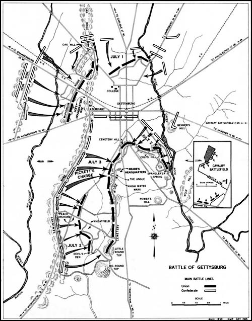
[Image: Map via University of Maine Civil War Webquest].

An “acoustic shadow” is when the sounds of an event—here, a battle—cannot be heard by people nearby—say, in the neighboring valley or a parallel city street—but those same sounds can plainly be heard over much larger distances. This effect is caused by “a unique combination of factors such as wind, weather, temperature, land topography, forest or other vegetation, and elevation,” we read. For example, “battle sounds from Gettysburg fought on July 1, 2, and 3, 1863 could be heard over one hundred miles away in Pittsburgh, but were not heard only ten miles from the battlefield.”

Without my own access to contemporary accounts of these battles and their acoustic shadows—sonic phantom limbs haunting distant landscapes—I simply have to trust the accounts that I’m quoting from here; nonetheless, these stories are fascinating. “More than 91,000 men were engaged in battle at Gaines’s Mill, Virginia on June 27, 1862,” for instance. “Confederate commanders and troops were less than two miles from the battlefield and could plainly see the smoke and flashes from the guns and artillery, but not a sound could be heard of the battle for two hours. Strangely, the battle sounds from the Battle of Gaines’s Mill were easily heard in Staunton, Virginia over one hundred miles away.”

The unexpected atmospheric reflection of sound, and sound’s complicated relationship with certain topographies, levels of humidity, climatic systems, and more presents an amazing—if impossibly complex—dimension to the future of urban design and landscape architecture. Could 5th Avenue be retrofitted to cultivate acoustic shadows—or might a neighborhood in eastern Brooklyn someday find itself overhearing distant traffic events and individual human conversations that have been carried on the winds from Midtown, acoustic effects soon traced back to the mirage-like venting of a new steam plant on the East River?

This also makes me wonder if instances of ghostlike visitation in ancient times—a king crazed by invisible whispers in his fortified tower bedroom, a city cursed by nocturnal voices, a village terrified by bodyless beasts unseen by any hunter—might actually have been examples of acoustic shadows. How could acoustic shadows be archaeologically and historically investigated without exactly reproducing the landscape topography and climatic conditions of the time?

(Vaguely related: a very old post about sound mirrors).

Warsound

[Image: U.S. helicopter over Baghdad, via (scroll down)].

I’ve mentioned The Forever War by Dexter Filkins before, but I was struck again the other day by a passage in which Filkins catalogs the mechanically unprecedented sounds of the American siege of Falluja, a collection of noises so alien and overpowering that he describes it as “an entire ecosystem” with its own hidden predators and prey.

Filkins writes that “rocket-propelled grenades whizzed out of the darkness, striking the M-1s and exploding but doing no harm. Whoosh-bang, like a fireworks show. Whoosh-bang.” He quickly adds, however, that “the real weirdness was circling above.”

The night sky echoed with pops and pings, the invisible sounds of frantic action. Most were being made by the AC-130 gunships, whose propellers were putting out a reassuring hum. But over the droning came stranger sounds: the plane’s Gatling gun let out long, deep burps at volumes that were symphonic. Its 105mm cannon made a popping sound, the same as you would hear from a machine that served tennis balls. A pop! followed by a boom! Pop-boom. And then there was the insect buzz of the ScanEagle, the pilotless airplane that hovered above us and beamed images back to base. It was as if we were witnessing the violent struggles of an entire ecosystem, a clash of airborne nocturnal beasts we could not see.

Of course, the unnatural acoustic ecology of humans at war is surely something you could find throughout history, from the fibrous zing of crossbow strings and the thunderous lurch of the catapult to endlessly irritating scrapings of metal on metal as swords and shields collide. What ancient Roman warfare actually sounded like is something for the acoustic archaeologists.

But, while an acoustic history of war has yet to be written—though some have treated sound itself as war—it would be a fascinating study to pursue.

Quick Links 9

Ten quick links for a Monday morning:
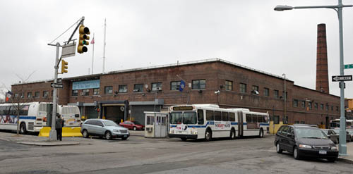
[Image: Photo by Richard Caplan for City Limits].

—An “African burial ground” lies beneath the floor of a bus depot in Harlem, City Limits reports, but “the only stone slab at the site [marking its historical importance] is the concrete floor of the Metropolitan Transit Authority bus garage sitting on top of tons of fill mingled with human remains.” That is subject to change, however, as “the Harlem African Burial Ground Task Force—composed of church leaders, activists, historians and elected officials—seeks preservation and official recognition of the colonial-era cemetery.” As DNAinfo.com adds, “Community members feared upcoming reconstruction of the bus depot, slated to begin in 2015, along with ongoing construction of the Willis Avenue Bridge, could disturb the remains of its former African burial ground located between 126th and 127th Streets along First Avenue.”
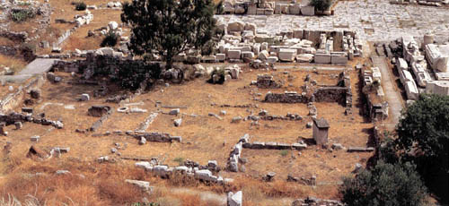
[Image: Eleusis, Greece, courtesy of the UCLA Archaeology Field Program].

—If I had a spare $8,000, I’d sign up for the UCLA Archaeology Field Program’s Eleusis 3D Archaeological Recording and Visualization Project: “Eleusis is world famous as the location of the Eleusinian Mysteries—a significant Athenian religious festival—and is located some 14 miles west of Athens opposite the island of Salamis. The students will record the site’s extensive architectural remains using terrestrial laser scanning, photogrammetry, GIS and GPS. 3D computer visualization and animation technologies will be used to re-create areas of the site.”
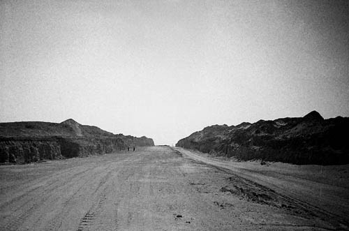
[Image: Dubai’s abandoned Arabian Canal project: “The Arabian Canal was meant to run for 75 kilometres through the desert,” photographer Tom Gara explains, “surrounded by luxury villas and apartment towers, creating an entire new city and doubling the size of Dubai”].

—”It will require an army of 10,000 construction workers, hundreds of giant drills and bulldozers, and four years of digging to get the job done,” we read courtesy of The National back in 2008. “A billion cubic metres of earth will be removed from the ground and turned into hills that rise as high as the Emirates Towers Hotel.”

The 75-kilometre-long Arabian Canal will join the ranks of the great civil engineering legends of the earth—like the Suez and Panama canals. Yet, unlike its predecessors, Dubai’s new US$11bn (Dh40.4bn) canal is being dug solely for its value to property development. On its banks a new city will rise with museums, hotels, apartment buildings, villas, shops—and a population of 1.5 million people.

Unfortunately, it is now a ruin—or, more properly speaking, an abandoned excavation cut through the Earth like a little-known desert work by Michael Heizer.
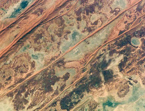
[Image: The shallow acidic lakes of desert Australia, courtesy of NASA-JSC].

—”Life not only survives but thrives in Australian lakes where conditions may be as harsh as those on ancient Mars,” New Scientist reports. “The lakes are very shallow and periodically fill with rainwater before partially evaporating, which concentrates the salts within them. They may be the closest equivalents on Earth of the shallow pools thought to have once dotted Mars.”

[Image: Cliffs of Mars, courtesy of NASA].

—Speaking of Mars, “the new Mars pictures are a confrontation with the sublime,” Sam Leith opines in the Guardian. “Look at these photographs of Mars, and you often can’t tell if you’re looking at miles, or metres, or microns. It’s a scale with nothing human to anchor it. It suggests an unsettling kinship between the alienness of both the very tiny and the very large.”

[Image: “A floating container vessel used by the UK during the 1982 Falklands War,” courtesy of Popular Science].

—The ever-awesome Popular Science—whose Twitter feed is well-worth following—explains that “a modular, self-assembling floating platform delivered by cargo ships could provide a cheaper naval base for military forces” in their battle against piracy. Making BLDGBLOG’s long-stated comparisons between Archigram and DARPA seemingly explicit, the “Tactically Expandable Maritime Platform (TEMP),” as it’s known, “would turn the standard ISO containers carried by cargo ships into modules that each serve a specific purpose, such as living quarters, command cells, comm shacks, or weapons stations. Once deployed by cargo ship, the self-propelling modules would use low-level computer brains to assemble themselves into a larger structure.” Mobile, modular, military instant cities at sea. Read a bit more at The Register.
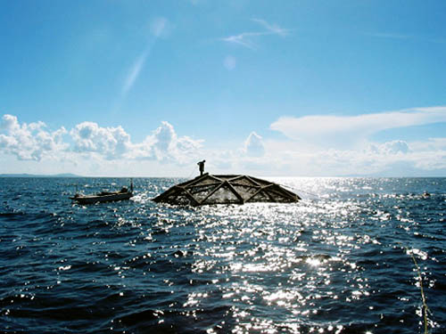
[Image: A glimpse of an Aquapod floating fish farm, courtesy of National Geographic].

—For a variety of reasons, that previous story reminds me of this report from National Geographic last summer: “In the future, giant, autonomous fish farms may whir through the open ocean, mimicking the movements of wild schools or even allowing fish to forage ‘free range’ before capturing them once again.” See more images here—and, in the process, read Pruned‘s 2008 take on the Aquapod farm module.
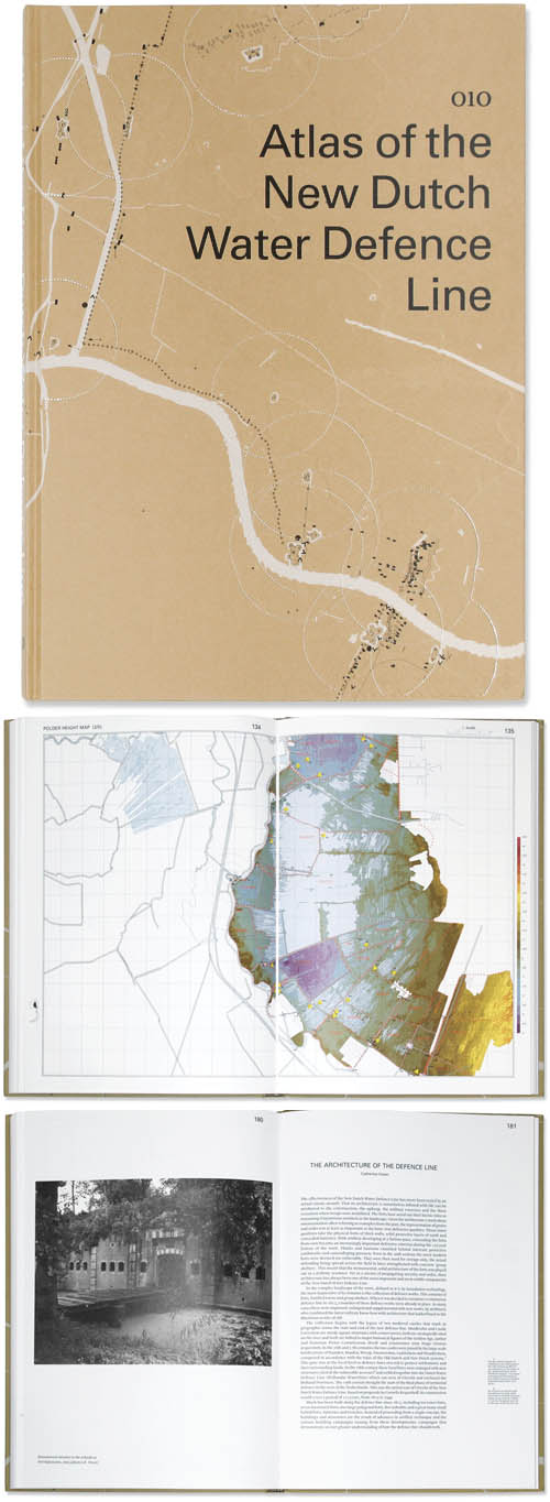
[Images: From Atlas of the New Dutch Water Defense Line].

—I really want to read this book, but I have yet to find a copy: Atlas of the New Dutch Water Defense Line.

This atlas addresses the New Dutch Water Defense Line (Nieuwe Hollandse Waterlinie) on a themed basis. Its position in the landscape, the forts, the inundation system, the geomorphology, the strategic system and recent developments can be read off in maps rendered so as to give an understanding of all aspects of the defense line landscape. The defense line reveals itself as a many-tentacled military defensive system of forts, group shelters and polders which can be flooded at the threat of war. The maps show the cohesion of the defense line as a landscape-strategic structure as well as the topographic composition of this structure in layers and components. The more detailed maps of the forts display the wealth of historic places, insertions in the landscape and defining elements.

It’s beautifully designed, as well.
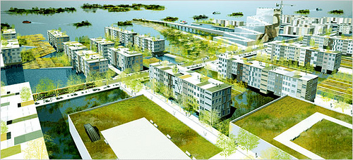
[Image: From a project by nARCHITECTS].

—”Abandoned neighborhoods. Boarded-up harbor facilities. An oil refinery submerged under several feet of brackish water. The Statue of Liberty slowly sinking into the sea. ‘Rising Currents: Projects for New York’s Waterfront,’ a new show at the Museum of Modern Art, reflects a level of apocalyptic thinking about this city that we haven’t seen since it was at the edge of financial collapse in the 1970s,” writes the beleaguered architecture critic for the New York Times. The show—open now through October 11, 2010—includes work by ARO and dlandstudio, LTL Architects, Matthew Baird Architects, nARCHITECTS, and SCAPE.
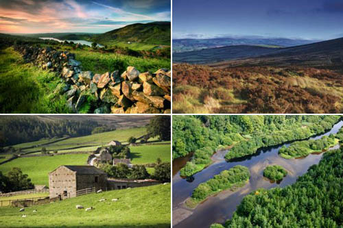
[Image: Areas of Outstanding Natural Beauty, courtesy of Geographical].

—Finally, “an Area of Outstanding Natural Beauty (AONB) is exactly what it says it is,” Geographical magazine explains: “a precious landscape whose distinctive character and natural beauty are so outstanding that it is in the nation’s interest to safeguard them.” Check out Geographical‘s guide to the UK’s 40 official sites of Outstanding Natural Beauty, including the Ring of Gullion, the Sperrins, the dams and ruins of Nidderdale, the abandoned mines of the Tamar Valley, and many more.

(Some links via Archaeology. Don’t miss Quick Links 1, 2, 3, 4, 5, 6, 7, and 8).
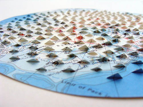
Supermodel

[Image: Thesis project by Vincenzo Reale, from a course taught by Alessio Erioli at the University of Bologna; photo by Alessio Erioli].

Here are two 3D-printed thesis projects from a course taught by Alessio Erioli at the University of Bologna; above you see work by Vincenzo Reale, below work by Riccardo La Magna. I have to admit to being utterly blown away by the formal possibilities of 3D printers, and these projects only make that obsession more extreme.

[Image: Thesis project by Riccardo La Magna, from a course taught by Alessio Erioli at the University of Bologna; photo by Alessio Erioli].

For one or two more images of these and other thesis projects, check out the Flickr stream of Alessio Erioli, where I originally saw these photos; for more on the future of (an admittedly different kind of) 3D printing, check out the recent, awesome article by Tim Abrahams in Blueprint Magazine: “In a small shed on an industrial park near Pisa is a machine that can print buildings,” we read.

The machine itself looks like a prototype for the automotive industry. Four columns independently support a frame with a single armature on it. Driven by CAD software installed on a dust-covered computer terminal, the armature moves just millimetres above a pile of sand, expressing a magnesium-based solution from hundreds of nozzles on its lower side. It makes four passes… The system deposits the sand and then inorganic binding ink. The exercise is repeated. The millennia-long process of laying down sedimentary rock is accelerated into a day. A building emerges. This machine could be used to construct anything.

Mimicking geology, we might forego architecture altogether and print new tectonic plates. Print earthquakes and mountain chains, archipelagoes at sea.

Table of Contents

[Image: From Table of Contents by LOOMstudio; photo by Don Vu].

LOOMstudio—whose work has been on BLDGBLOG before (and I’m also a fan of their Sheep Barn project)—produced what they called the Table of Contents for a group show at Minneapolis’s Form+Content Gallery last summer.

The Table of Contents is a machine to decipher the housing crisis; a hybrid of game board, dining table, and scale model. It records evocative and uncanny housing “values” within a neighborhood in North Minneapolis through interactive discovery and play.

That description isn’t the most helpful text in the world, but you can see from the images re-posted here that the result is landscape, machine, stage-set, and exploded box by Joseph Cornell all in one.

[Image: From Table of Contents by LOOMstudio; photo by Don Vu].

Grass lawns with sawed-off tree trunks sit beside card games that have yet to begin, while copper pipes hold inexplicable rubber gloves full of marbles and a tea kettle (or is it a bedpan?) hangs nearby. Newspaper clippings like stars drift overhead in slowly moving constellations. Tiny ecosystems grow inside overturned Mason jars and the door of a safe sits sprung wide open, as if robbed.

[Images: From Table of Contents by LOOMstudio; top two photos by Don Vu].

The project is not available on the architects’ own website, but you can check out the Flickr set here.

The Extra Room

The Extra Room is a project by Bernhard Hopfengärtner and TheGreenEyl; it went on display last year as part of the What If… show at the Science Gallery in Dublin.

[Image: From The Extra Room by Bernhard Hopfengärtner and TheGreenEyl].

The Extra Room proposed a secret space “built into the basement of a multi storey building where it is shared by the house’s inhabitants,” and inside of which those inhabitants could spend time alone and practice “protective self discipline.”

“Utilising effects of sensory deprivation and methods used by the military to break someone down,” the artists explain, “the room enables subjects to adjust their thinking and beliefs.” It is a sensory-deprivation chamber by another name, in other words, a “reversed disciplinary architecture” in which you can lose yourself in the facets of a silent, white geometry and temporarily go a bit nuts. Think of it as a room for Socratic self-interrogation in an era of waterboarding and Guantanamo Bay.

While the actual image, seen above, is by no means the most interesting illustration that could have been produced for this project, the basic idea behind it—that architects, sociologists, and even behavioral psychologists could someday team up to explore a new architecture with deliberately cultivated neurological side-effects—suggests a moral risk to the design of private space that deserves further exploration. In fact, the idea that we could build a kind of psychological sacrifice zone in the basement of a residential high-rise is a narratively compelling one. Perhaps an entire district of the city could be architecturally adapted for the needs of self-experimentation, testing your own limits in the face of strange ornament and topologically inconsistent space. You receive a prescription for a five-hour visit to the Extra Borough, and you walk in, alone, faced with odd, windowless buildings and empty squares on either side. It is an urban arena for a new breed of psychological X-Games.

L.A. on the Nile

[Image: From the Los Angeles Times photographic archive at UCLA Library; copyright Regents of the University of California, UCLA Library].

The above image, originally published by the L.A. Times in 1965 and now in a collection at UCLA, shows “electric streetcars that once carried passengers on Los Angeles streets” being loaded by crane onto “the Liberian ship Santa Helena at Long Beach Harbor.” The boat soon thereafter set sail for Cairo, Egypt, as the streetcars had been purchased by that city’s own Transportation Co. “The streetcars will be used,” the caption adds, “in Alexandria, Egypt.” So, like something out of a story by Ignacio Padilla, if you want to experience a lost chapter in Los Angeles public transportation history, perhaps you need to book a flight to Cairo and head north toward the Mediterranean Sea.

Vivarium

[Image: Inside Vivarium].

Juan Azulay‘s Vivarium project opens to the public tonight, Friday, March 26, over at SCI-Arc. Vivarium “explores the relationship between technology, media, and environmental preservation/dereliction,” we read, “[…] by placing itself in the midst of processes of intense transformation within the ecosystem it has isolated.”

[Images: Cladding for Vivarium].

The bulk of the exhibition space will feature a “sunken pyramid” that houses the “vivarium”; the vivarium itself will contain “three types of organisms. Living microorganisms will transform the vivarium’s air-moisture into salt. Robotic-engineered organisms made for the installation will in turn generate heat. Virtual (digital) organisms will mimic the behavior of both the living and robotic microorganisms.”

These living/semi-living/replicant/undead/digital organisms will thus transform “a freshwater ecosystem into a brackish one… creating a new hybrid ecology that will grow and self-stabilize throughout the exhibition period of three months.”

[Images: Assembly diagrams for Vivarium].

I’m reminded of an Ecosphere I had in my work desk a year or two back, a glass sphere inside of which two little shrimp—barely perceptible to the naked eye—swam around living plantlife while I edited articles nearby, only Vivarium blows that up to the scale of installation architecture while simultaneously scattering an oddly post-mortem (or is it pre-?) collection of quasi-organisms into the mix. An aquarium left alone in a VR cave until it thinks it’s dreaming.

Azulay will be discussing the project in a public event at SCI-Arc on April 9, so be sure to check that out if you have any questions.

Klip House

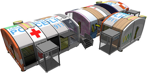
[Image: The Klip House system by Interloop architects].

The Klip House by Texan architects Interloop is a project dating back to 1997-2001. The architects describe it as “a delivery system that provides the physical and operational infrastructure for trade corporations to participate in the production, delivery, and servicing of housing.”

Not limited only to housing, however, the Klip system was seen as being just as easy to use for hospitals, police stations, and more—even, why not, a pink auto-detailing shop.

[Image: A pink auto-detailing shop in the Klip system by Interloop].
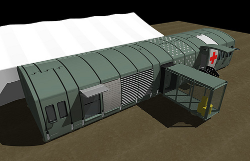
At the time, Interloop had become “frustrated,” they explain, by “Federal and State initiatives that provide financial assistance to qualified families and individuals by awarding housing ‘vouchers’ to serve as the down payment on a house. In its current format, the voucher system distributes a mass of capital such that one voucher equals one house.” However:

We were, and are, frustrated with a design system that is constricted by insurance companies, loan officers, municipalities, and contractors, etc. and decided to look at the overall economic impact that these vouchers might have if they were bundled, rather than distributed. Instead of designing a single house that has very little impact to the housing industry, we worked with the idea of consolidating the vouchers to pay for a housing platform, or infrastructure. We needed to work outside of the home mortgage process in order to gain some ground.

In other words, producing new housing also means producing new (non-predatory) ways to finance those housing options—architects have to rethink systems of payment as much as they have to rethink the design parameters of prefab componentry.

[Images: The Klip system by Interloop].

Klip House, seen here, “is essentially engaging financing systems that exist in automotive and product industries”—a statement which comes with a slight twinge of nostalgia for those heady, Greg Lynn-inspired days of the late 1990s when automobile assembly was the reigning model for cutting-edge architectural thesis projects. If your BMW could be assembled offsite and to your every specification, down to heated seats, aerodynamic rear spoilers, and the perfect JBL sound system, why couldn’t the architecture you live in follow suit?

Seamless, robotic, and delivered perfectly on schedule, the modular assembly of housing—borrowing assembly line techniques taken from Ford, Saturn, or Lexus—was to lead the way to our architectural future.

In any case, the Klip house itself was at least partially inspired by the boot clips of skis and snowboards. That is, its foundation would operate through a terrestrial “binder,” or “adjustable footing system,” onto which new rooms or components could be clipped (thus the house’s name).

The binders thus allow for “an open array of housing components [to] be added, released, interchanged, upgraded and rearranged” at will. “The architectural contribution,” Interloop points out, “is simply to introduce a single enabling technology, i.e. the binder, to generate or illicit response.”

[Images: Inspired by the boot clips of snowboards: the Klip‘s binder system by Interloop architects].

Further, the Klip’s “components are available in three and six foot widths, each made with a variety of options and upgrades,” and they can be either purchased or leased. This adds a Smart Car/iPod-like personalization to the housing design and procurement process.

Your house, hospital, police station, nightclub, field kitchen, mobile writing lab, counterfeit university space, or auto-body shop can thus be expanded (or shrunken)—let alone recolored, retextured, and resurfaced—based on immediate personal and economic needs.

[Image: The Klip House by Interloop architects].

Read more at the architects’ website.

Shanghai Seedling

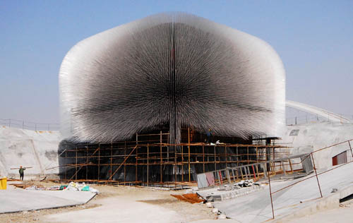
[Image: Thomas Heatherwick’s “Seed Cathedral” at the 2010 Shanghai World Expo; photo by Reuters/China Daily, via The Big Picture].

I have to admit that, however over-exposed this building might be, it is one of the coolest architectural constructions I’ve seen in a long time—and while I say that in the most superficial way imaginable, i.e. I just think it looks really, really cool, this structure, the so-called “Seed Cathedral” by Thomas Heatherwick, under construction in Shanghai for this summer’s 2010 World Expo, has an amazing ulterior motive: at the end of every one of the 60,000 transparent acrylic rods that you see fuzzing outward into the sunlight are the seeds of plants.

[Image: The seeds revealed; photo by Aly Song for Reuters, via The Big Picture].
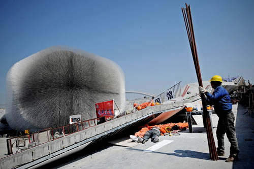
The result looks very much like an expansion of Heatherwick’s earlier work Sitooterie II, but the final design also incorporates seeds from the Kew Millennium Seed Bank project.

From the New York Times last autumn: “Heatherwick and his team worked with Kew’s Millennium Seed Bank partnership to showcase Britain’s commitment to conservation. They encased thousands of seeds in the ends of the transparent rods, creating a larger-than-life catalog of the plant species that contribute to national and global conservation programs, in a veritable cathedral of seeds.”

[Images: Thomas Heatherwick’s “Seed Cathedral” prepares to open in Shanghai; photos by Philippe Lopez/AFP/Getty Images; STR/AFP/Getty Images; and AP; all via The Big Picture].

Seed vaults have long been of interest here, of course, but this non-doomsday-inspired celebration of terrestrial botany is, for me, surprisingly much more thrilling than some top secret polar room predicated on an end-of-the-world agricultural scenario. Perhaps every town should have its own seed cathedral, blur-buildings of acrylic rods to showcase their local flora.