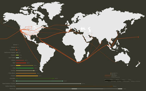
 Like a culinary version of Sourcemap, Rebar has teamed up with landscape architect David Fletcher and some students from the increasingly interesting California College of the Arts in San Francisco to explore the ingredients of your local taco—from pinto beans to the aluminum foil it all comes wrapped in.
Our premise was that a seemingly simple, familiar food like the taco truck taco could provide visceral insight into the connections between the systems we were exploring [in our studio’s investigation of the city]. By thoroughly learning the process of formation and lifecycle for what it takes to make a taco, we would be better able to propose and design a speculative model of a holistic and sustainable urban future. What resulted was a richly complex network of systems, flows and ecologies that we call the global Tacoshed.
This is a participatory undertaking; meet at the Studio for Urban Projects in San Francisco at 7pm on Thursday, February 25, to find out how you, too, can map a taco. Here’s a map.
The Studio for Urban Projects, meanwhile, has a pretty fascinating list of previous endeavors, including Foodshed, Strange Weather, and the awesome Unnatural History of Golden Gate Park. Large parts of what are now west San Francisco were once covered by nomadic sand dunes, a kind of peninsular erg; that granular presence is now only temporarily locked in place beneath the foundations of houses. Every grain you see blowing down a San Franciscan street is this lost geography attempting to reassert itself.
 [Image: “There are two basic types of taco trucks,” we read; “the first and most common is the transient truck which is a truck that stops at approximately 20 different locations at 20-minute intervals during an 8-hour shift, typically beginning at 6am and ending at 2pm. The second type is the semi-permanent truck, which is a truck that has found a location that has a density of clientele to sustain it for an extended period of the day, creating a nearly fixed presence in a particular community.” From Polar Inertia].
And I can’t let this post end without calling attention to the excellent—in fact, extraordinary—Polar Inertia, specifically its photo-essay published more than four years ago tracing the taco-truck geography of greater Los Angeles. These dispersed infrastructures might now be quite trendy, but the functional networks things like taco trucks actually form on the streets of our cities are still worth mapping in full.