Breaking Out and Breaking In Finale

[Image: Poster design by Atley Kasky of Outpost].

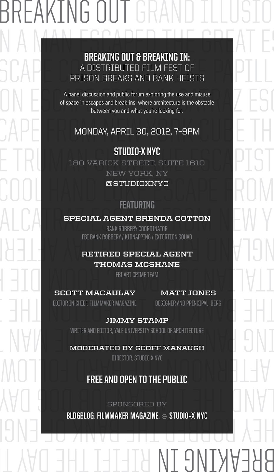
Although I hope to post again about the specific topics to be discussed at this event, I didn’t want to lose any more time in announcing the Breaking Out and Breaking In final public event to be hosted at Columbia University’s Studio-X NYC on Monday, April 30, featuring a unique and exciting panel of discussants drawn from the worlds of film, design, history, architecture, and the FBI.

Stop by to hear Special Agent Brenda Cotton, Bank Robbery Coordinator for the FBI’s Bank Robbery/Kidnapping/Extortion Squad; Thomas McShane, Retired FBI Special Agent from the Bureau’s Art Crime Team and co-author of Stolen Masterpiece Tracker; Scott Macaulay, editor-in-chief of Filmmaker Magazine, co-sponsors of the Breaking Out and Breaking In film festival; Matt Jones, designer and principal at BERG; and Jimmy Stamp, writer and editor at the Yale University School of Architecture and co-organizer of last year’s symposium on the architecture of the getaway, the hideout, and the coverup.

The event is free, open to the public, and kicks off on April 30 at 7pm sharp. We’ll be at 180 Varick Street, Suite 1610, on the 16th floor; here’s a map. Stop by for a panel discussion and open Q&A about the spatial scenarios of real and cinematic crimes, from armored car heists to panic rooms, from Boston art thefts to Los Angeles bank tunnels, and from the internal layouts of financial institutions to the unanticipated criminal side-effects of urban design, exploring the built environment from the perspective of the crimes that can be planned and foiled there.

Ephemeral islands and other states-in-waiting

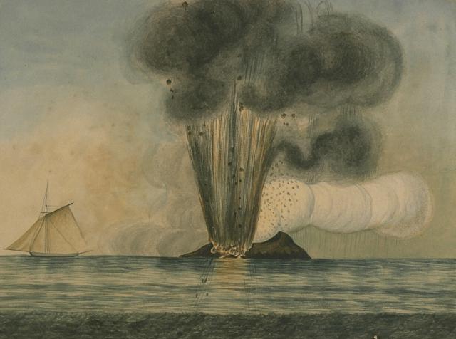
[Image: Temporary islands emerge from the sea, via].

In the Mediterranean Sea southwest of Sicily, an island comes and goes. Called, alternately and among other names, depending on whose territorial interests are at stake, Graham Bank, Île Julia, the island of Ferdinandea, or, more extravagantly, a complex known as the Campi Flegrei del Mar di Sicilia (the Phlegraean Fields of the Sicily Sea), this geographic phenomenon is fueled by a range of submerged volcanoes. One peak, in particular, has been known to break the waves, forming a small, ephemeral island off the coast of Italy.

And, when it does, several nation-states are quick to claim it, including, in 1831, when the island appeared above water, “the navies of France, Britain, Spain, and Italy.” Unfortunately for them, it eroded away and disappeared beneath the waves in 1832.

It then promised to reappear, following new eruptions, in 2002 (but played coy, remaining 6 meters below the surface).

The island, though, always promises to show up again someday, potentially restarting old arguments of jurisdiction and sovereignty—is it French? Spanish? Italian? Maltese? perhaps a micronation?—so some groups are already well-prepared for its re-arrival. As Ted Nield explains in his book Supercontinent, “the two surviving relatives of Ferdinand II commissioned a plaque to be affixed to the then still submerged volcanic reef, claiming it for Italy should it ever rise again.” This is the impending geography of states-in-waiting, instant islands that, however temporarily, redraw the world’s maps.

The story of Ferdinandea, as recounted by that well-known primary historical source Wikipedia and seemingly ripe for inclusion in the excellent Borderlines blog by Frank Jacobs, is absolutely fascinating: it’s appeared on an ornamental coin, it was visited by Sir Walter Scott, it inspired a short story by James Fenimore Cooper, it was depth-charged by the U.S. military who mistook it for a Libyan submarine, and it remains the subject of active geographic speculation by professors of international relations. It is, in a sense, Europe’s Okinotori—and one can perhaps imagine some Borgesian wing of the Italian government hired to sit there in a boat, in open waters, for a whole generation, armed with the wizardry of surveying gear and a plumb bob dangling down into the sea, testing for seismic irregularities, as if casting a spell to coax this future extension of the Italian motherland up into the salty air.

Glass Hills of Mars

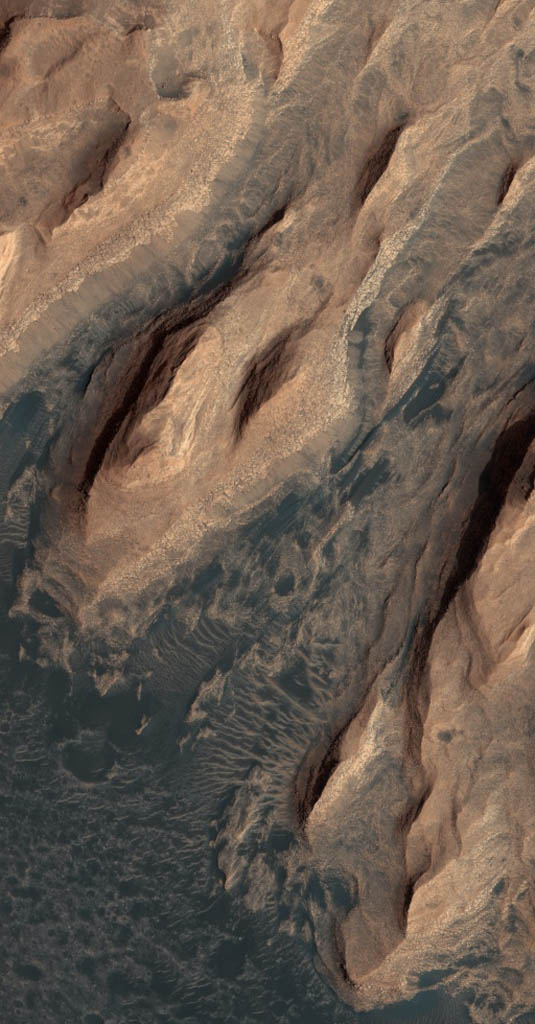
More than 10 million square kilometers of landscape on the surface of Mars, a region nearly the size of Europe, is made of glass—specifically volcanic glass, “a shiny substance similar to obsidian that forms when magma cools too fast for its minerals to crystallize.”

[Image: An otherwise randomly grabbed image of Mars from the fantastic HiRISE site].

In a paper called “Widespread weathered glass on the surface of Mars,” authors Briony Horgan and James F. Bell III, from the School of Earth and Space Exploration at Arizona State University, go on to suggest that “the ubiquitous dusty mantle covering much of the northern plains [of Mars] may obscure more extensive glass deposits” yet to be mapped.

Although it’s worth emphasizing that this glass is present mostly in the form of “Eolian” grains—that is, small pieces of windblown sand accumulating in dune fields—it is, nonetheless, a sublime scene to consider, with endless glass ridges and hills rolling off beneath stars and red dust storms, slippery to the touch, as hard as bedrock, cold, perhaps glistening and prismatic inside with distorted reflections of constellations, like blisters of light on a television screen coextensive with the surface of the planet. You could slide from one hill to the next, for hours—for days—alone on a frozen ocean of self-reflecting landforms, dizzy with the images locked within.

(What would a glass farm look like, agriculture carved into crystalline ridges, cultivating strange geologies? Meanwhile, ages ago, in a different lifetime on BLDGBLOG: Mount St. Helens of Glass).

Hydro-Electro-Musical Machinery

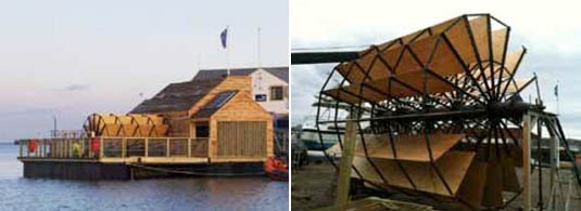
[Image: Flow].

A floating tidemill on the UK’s River Tyne has been filled with “electro-acoustic musical machinery,” powered by the river itself. The building, a collaboration between Owl Project and Ed Carter, called Flow, is “a floating building on the River Tyne that generates its own power using a tidal water wheel.”

The acoustic machines inside, powered by CNC-milled wooden gears and timber pistons, “respond directly to the ever-changing state of the river. The sounds created by each instrument can also be manipulated by visitors to the millhouse.”

[Images: Flow].

Specifically, the floating auditorium includes “three inter-connected sonic instruments which mix traditional craft and digital innovation. They draw water from the River Tyne, passing it through a series filters, lasers and sensors, which bubble, beep, hiss, creak and groan.” For at least one instrument, the resulting sounds are determined by the salt-content of the water: “A wooden mechanism then dips a series of electrodes into the jars and creates a series of sounds. The pitch of the sounds will be modified depending on the salinity levels of the water.”

The installation is thus also a kind of lo-fi river research station, supplying data about the water it floats within (in the designers’ words, it uses “a range of traditional and new technologies to monitor key environmental details, including water temperature, speed, salinity, and pollution”).

[Images: Flow].

Finally, “Owl Project has designed a series of Log interfaces to alter the sounds the instruments make,” literal pieces of wood with knobs and levers that produce acoustic special effects.

[Images: Flow].

It seems obvious to describe this as a kind of mobile version of the Sea Organ in Zadar, Croatia—or the San Francisco Wave Organ—with the addition of fine woodworking skills and some quasi-scientific instrumentation. Putting this into the context of a project like “Amphibious Architecture,” featured here a few years ago, it’s easy to imagine an acoustic early-warning system for pollution, floods, and even the appearance of rare marine wildlife. A city’s waterfront—a whole bay—ornamented by singing buoys.

You can follow the project on Twitter, and there is theoretically a live-stream of sounds here. If any readers out there happen to hear it in person, let me know!

(Spotted via The Wire).

Building in a Bottle

[Image: Piece of Nature Preserved (1973) by Haus-Rucker-Co; photo by Hagen Stier, courtesy of the Deutsches Architekturmuseum].

A forthcoming exhibition at the Deutsches Architekturmuseum in Frankfurt explores the world of the architectural model, from Frei Otto and Rem Koolhaas to Peter Eisenman.

The above piece, by Haus-Rucker-Co, called Piece of Nature Preserved (1973) seems worthy of highlighting. “The small hut is a tongue-in-cheek commentary on the longing for a simple, back-to-the-roots way of life,” the museum suggests. “Nature unharmed by destructive environmental forces can only be created in a glass capsule, as a model in the shape of a preserving jar.”

The exhibition opens the evening of May 24.

Every House Has Cracks

[Image: Via English Russia].

In a story seemingly invented for future landscape architecture thesis projects, we find the city of Berezniki, Russia. “In the West,” the New York Times explains, “mines are usually located far from populous areas, to reduce the risks of sinkholes to homes and other buildings. But Berezniki, a city of 154,000 that began as a labor camp, was built directly over the mine—a legacy of the Soviet policy of placing camps within marching distance of work areas.”

With collapsing salt pillars and widespread erosion in the derelict mines below the city, Berezniki is thus “afflicted by sinkholes, yawning chasms hundreds of feet deep that can open at a moment’s notice.”

[Image: Via English Russia].

Incredibly, like a geologically-themed remake of The Truman Show, the city has responded with “24-hour video surveillance.”

On a screen in the command center late last year, one such hole appeared as a small dark spot in a snowy field in the predawn hours, immediately threatening to suck in a building, a road and a gas station. “I looked and said, ‘Wow, a hole is forming,'” recalled Olga V. Chekhova, an emergency services worker who monitors the video… While scientists have so far successfully predicted each sinkhole, the chasms can open with astonishing speed. On Dec. 4, as Ms. Chekhova watched the dark spot on her screen expand, witnesses began calling an emergency number for reporting sinkholes. They had heard a loud swooshing noise.

The town has decided to “fight the holes with science,” putting in place “a panoply of high-technology monitors. These include the video surveillance system, seismic sensors, regular surveys and satellite monitoring of the changes in altitude of roofs, sidewalks and streets.”

While the design possibilities of a town off-kilter with itself are clear, the Times article seems to undersell the incompetence of the city officials, mine engineers, and policy-makers who oversaw the creation of the underground facilities in the first place and who made the idiotic decision to locate a city overtop land that would subsequently be excavated. Having said that, the photo gallery accompanying the original article—unlike the more sensationalist images I’ve chosen here—focuses on the people who actually live there, families who watch as cracks appear in their ceilings and walls, looking around at furniture they can’t afford to move and the neighborhoods that seem on the verge of, in the article’s words, “being sucked into the earth.”

“In my view, we need to move the entire town,” one of the residents says, with what seems like obvious melancholy. He’s not reaching for a sketchbook or planning robotic future cities on stilts. “Every house has cracks.”

Ghost Town Climatology

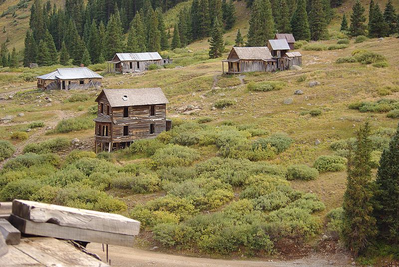
[Image: The ghost town of Animas Forks, Colorado, via Wikipedia].

Fred Chambers, an Associate Professor of Geography and Environmental Sciences at the University of Colorado, is studying what he calls “ghost town climatology,” or the declining temperature of a region as it is abandoned by human activity. He describes it as “a reverse urban heat island effect.”

There’s not much info available right now on his website, but the idea of weather patterns being generated by ghost towns—abandoned villages in the mountains creating artificial winters that haunt those in the city down below—is a captivating one. As if, to exaggerate the study’s implications, you could hike up into the hills one day and locate the source of all that snow, stumbling, half-blind and frostbitten, into a dead valley of churches and town halls, fighting against a wind those empty buildings help to generate.

New York Quarry

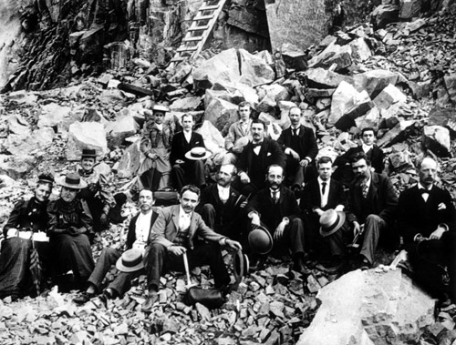
[Image: Gentlemen quarriers of a golden age, via].

Following on from earlier looks at the city as mining district, including a quarry on the Lower East Side, I was interested to read that parts of Manhattan were once productive marble quarries. A street and surrounding small neighborhood called Kingsbridge, in particular, was “an early quarrying district on Manhattan island.”

In a 1997 article for the Mineralogical Record, Lawrence H. Conklin relates his discovery, like something out of Jules Verne, of a 19th-century print called “Marble Quarry, Kingsbridge, N.Y. (1819),” thus piquing his interest in these and other excavations around Manhattan’s northern end. “The acquisition of the drawing spurred me to explore the printed record,” Conklin writes, “to find out what could be learned about marble and mineral specimen production at Kingsbridge, and especially about the quarry and the house depicted in the sketch.”

[Image: A quarry site that now “lies in the bed of the present Harlem River,” via].

Digging around in various archives, Conklin goes on to locate references to old quarries along what is now Broadway. The bracketed note in the following quotation is Conklin’s:

“From 213th to 217th street the road [called at the time the Kingsbridge road and now known as Broadway] passed along the foot of the eastern slope of marble quarries.” This places additional marble quarries in Kingsbridge, in the year 1808, on the lands of the Dyckman family and elsewhere. The Dyckmans at one time owned the largest single tract of land in the history of Manhattan and were honored by the naming of present-day Dyckman Street, an important east-west thoroughfare that traverses their former lands.

When the quarries were later abandoned, they filled with water, becoming ponds (and, in the winter, small ice-skating rinks); however, in many cases, these already coastal land features were “obliterated” by the navigable straightening of the Harlem River.

[Image: Nautical chart of the Harlem River, courtesy of NOAA].

But there are other quarries out there that have since been built over, and that remain covered over or filled in by architecture. There might even have been, Conklin speculates, a large-yielding quarry “situated on land that is now occupied by Columbia University’s Baker Field.” It’s fascinating to consider even the possibility that there are buildings on the northern end of Manhattan whose basements are, in fact, former quarries, large artificial caverns hewn directly from bedrock, negative sculptures in which people now do laundry or park cars (or, who knows, wander around at night for hours, flashlight in hand, amazed at these labyrinths that stretch for miles, across state lines, underneath rivers, out beneath the sea).

The story of the quarries is long, as the same veins of rock that criss-cross Manhattan were also exploited further afield, at sites in Connecticut and upriver, and, if you’re into that sort of thing, it’s worth a quick read.

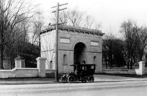
Finally, though, there is a juxtaposition of two historical photographs in Conklin’s post that I feel compelled to reproduce here; it’s like Piranesi-on-Hudson—or on 216th Street, as the case may be.

[Image: Manhattan Piranesi, via].

A ruined arch made from quarried Manhattan bedrock later covered in signs and spraypaint, all but buried in the visual mess of the modern city.

(More on the minerals of NYC).

Star Garden

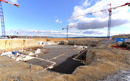
[Image: Building the International Thermonuclear Experimental Reactor; ©ITER Organization].

An artificially excavated limestone pit in the south of France will soon host star-making technology, New Scientist reports. “If all goes well,” the magazine explains, in a few year’s time the pit will “rage with humanity’s first self-sustaining fusion reaction, an artificial sun ten times hotter than the one that gives our planet life.”

[Image: Building the International Thermonuclear Experimental Reactor; ©ITER Organization].

Reaching that point, however, requires an ambitious reformatting of the entire site, seemingly the very limit of landscape architecture: a kind of concrete garden that produces stars.

As the project now stands, construction involves inserting a supergrid of rebar into the quarried pit, securing the limestone walls with concrete foundation work, then pouring seismically-stabilized plinths that will support the so-called International Thermonuclear Experimental Reactor (or ITER) upon completion.

[Image: Checking plinths at the International Thermonuclear Experimental Reactor, as if Peter Eisenman’s Holocaust Memorial in Berlin could be repurposed for building stars. Photo ©ITER Organization].

Superficially—i.e. they’re both in France and they both involve limestone—I’m reminded of the Crazannes Quarries project by Bernard Lassus, for which cuts, sections, “artificial rock formations,” shaped cliffs, and other designed geologies were introduced into and through the side of a French road. In effect, Lassus milled a new, powder-white landscape from the limestone.

But the ITER project seems to take the ambitions of Crazannes and turn them up to a nearly overwhelming degree: using a (to be clear, all but unrelated) landscape design process to produce moments of stellar combustion on the earth. It’s like an undeclared monument to Giordano Bruno—or, for that matter, to Aleister Crowley. A quarry in which we’ll build stars.

In any case, nestled there in its semi-subterranean, mine-like site and buzzing inside with radiation-resistant robot elevators, each “about the size of a large bus,” the ITER will recreate, again and again, “the process that powers the sun and most other stars. At extremely high temperatures, hydrogen nuclei will fuse to form helium, spitting out more energy than the process consumes, something that has never yet been achieved by a human-made device.”

[Image: A blanket of rebar is installed inside the pit at the International Thermonuclear Experimental Reactor; ©ITER Organization].

The photos seen here—reproduced in accordance with ITER‘s image-use policy—shows the site work in action: quarrying, gridding, pouring, smoothing, and stabilizing, in preparation for the birth of new heavens.

[Images: Building the International Thermonuclear Experimental Reactor; ©ITER Organization].

More images are available at the ITER website.

Spaces on Spec

A few opportunities for those of you looking for new outlets:

1) Kerb, the journal of landscape architecture from RMIT University in Melbourne, is publishing its 20th issue, on “speculative narrative” and other “fictional dispositions” in the field of landscape design. Submissions are due May 4.

[Image: Kerb 20].

Read more on their website.

2) Spend three weeks in a renovated cotton mill in the woods of upstate New York, drawing, projecting, building, and discussing architecture. Arts Letters & Numbers, run by the Cooper Union’s David Gersten, “is conceived of as: an architecture, a theater, a film, a drawing, a conversation, an action, a reenactment and a school, all inside each other.” The workshop will begin “by drawing in the landscape with the elements; fire, air, water, and earth. These explorations will be a starting point for an evolving conversation between inside and outside, between fire and film, water, theater, air, drawing, earth and architecture. The entire site will be used to explore these interactions and develop amplifying exchanges and unpredictable questions.”

[Image: The cotton mill].

There will be daily seminars, visiting lecturers, near-continuous workshops, and don’t forget “great food.”

The photos below document a related workshop, also run by David Gersten, held in Aarhus, Denmark; while the space in upstate New York presents a different set of possibilities for work and display, a similarly immersive approach will be followed.

[Image: Photos from Aarhus Arc, led by David Gersten].

Applications are due May 1, and the workshop itself runs July 7–28. More information is available on the workshop website.

3) The newest issue of The State dives into the spatial imagination of “speculative geographies.”

We welcome submissions around the theme of “Speculative Geographies,” and encourage experimentation with form, transmedia, and (web)site-specific installations; critical texts, interrogative narratives, slow journalism, sensuous net-artwork, moving or still images, psychogeographic mappings, place hacking, manifestos and conversations, among others. Because of the nature of The State, please do not feel restricted by the above; please feel free to alternatively submit a wall of text.

Submissions are due April 30.

[Image: Urban Animal].

4) The Animal Architecture Awards are back with a look at the “urban animal.”

Urban areas are quickly becoming the densest concentrations of human life on the planet and with that comes the well documented positive and negative impacts to local biodiversity and ecologies. But humans are not the only urban animals—squirrels, pigeons, mice, rats, crows, raccoons, beetles etc.—all species identified as synanthropes—that “live near, and benefit from, an association with humans and the somewhat artificial habitats that humans create around them.” These are highly-urbanized non-human animals and our potential design partners.

Accordingly, “Animal Architecture wants your ideas about how synanthropic design can reshape, expand and redefine the context of urban thought and space.”

Register by May 13—and check out a few submissions to last year’s Animal Architecture Awards here on BLDGBLOG.

5) Finally, for those of you Down Under, Open Agenda is seeking “text and graphic based proposals that seek to develop research through architectural design” specifically from “graduates from a professional Australian or New Zealand degree [program] in architecture in the last ten years.” Register by May 27th.

[Image: Open Agenda].

Good luck!

Tunnel Plug

[Image: The plug, courtesy of Homeland Security’s Resilient Tunnel Project, via Wired UK].
The U.S. Department of Homeland Security’s “Resilient Tunnel Project” has come up with a prototype 35,000-gallon “plug,” or “enormous inflatable cylinder,” in the words of PhysOrg.com, one that is “tunnel-shaped with rounded capsule-like ends” and “can be filled with water or air in minutes to seal off a section of tunnel before flooding gets out of control.”

The idea is to prevent underground floods from taking down whole subway systems or otherwise destroying subterranean logistical networks, such as telecom cables (or Chicago’s infamous abandoned coal-delivery tunnels).

The plug itself is made from tear-resistant fabrics—including liquid-crystal polymers—that can expand around irregular surfaces and objects, producing, in effect, an impassable blockade. As Wired UK points out, this means the plug could also be used as a quarantine barrier, stopping the passage of chemical or biological agents.

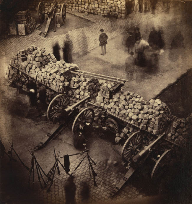
On an unrelated note, meanwhile, I’m looking forward to receiving a review copy of The Insurgent Barricade by Mark Traugott next week, and, in the context of that book, this “enormous inflatable cylinder” could take on other, aboveground roles, such as intervening in and impossibly redirecting urban movement (both in the name of security and insurgency). To put this in somewhat absurd terms, what might the Paris Commune have looked like, for instance, had its participants used giant, knife-proof inflatable objects, like revolutionary sausages blocking access to whole streets?

[Image: Paris barricade made from cobblestones (1871), photographed by Pierre-Ambrose Richebourg, via Wikipedia].

In any case, whether or not these or other such “plugs” will be permanently installed, like automotive airbags, inside underground infrastructure is yet to be decided; but it seems quite likely that affordably fabricated, inflatable barriers will become regular architectural safety features of a subterranean system near you.