
 [Images: The forests of northern Michigan, via Google Maps].
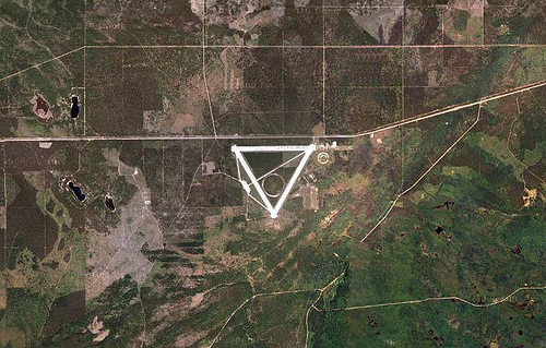
In the woods of northern Michigan, near Hiawatha National Forest, is a massive triangle, unnamed and unlabeled on Google Maps.


 [Images: Geometry amidst the forest, via Google Maps].
But, despite its anonymity (it even disappears from view altogether when you switch from “Satellite” to “Map“), this is not some underground HQ for a secretive cult of aerially-minded geoglyph-builders, and it’s not more scientological circles—it’s a former military base and landing-strip complex called Raco Army Airfield.
As it is, the site’s monumental geometry, with its northernmost airstrip aligned almost perfectly east-to-west, makes a massive and slightly puzzling triangle in the middle of heavy forest.
 [Image: Raco Army Airfield, via Google Maps].
Raco AAF is a facility that has seen a variety of different uses, according to the website Abandoned & Little-Known Airfields: “The site of the pre-WW2 civilian Raco Landing Field was evidently reused by the military at some point after 1940 for the construction of a much more elaborate military airfield, intended to provide protection to the Sault Sainte Marie locks.” However, “As no threats materialized to the locks, the airfield was apparently little-used, or possibly never used at all.” Anti-aircraft guns were nonetheless installed on concrete pads in the surrounding forest; these pads remain in the woods today, overgrown with moss and tree roots, offering an unexpected and highly artificial surrogate bedrock for the ecosystem around them.
 [Image: A plan of the site, via Abandoned & Little-Known Airfields].
The facility was later armed with nuclear missiles:
Part of the airfield property was later reused by the Air Force to build a launch site for the huge BOMARC ramjet surface-to-air missiles. The BOMARC was a long-range surface to air missile, intended to shoot down Soviet bombers with a nuclear warhead.
This facility was known as the Kincheloe AFB BOMARC site, and it was manned by the 37th Air Defense Missile Squadron starting in 1960. The BOMARC site was a rectangular installation, just southeast of the runways. It operated the 2nd-generation IM-99B version of the BOMARC missile. The site consisted of a grid of 28 individual missile launcher buildings on the south end, along with larger missile assembly buildings on the north end.
The whole thing was shut down in 1972.
Abandoned & Little-Known Airfields goes on to quote a man named David McLaren: “I visited Raco AAF back in 1974 after spotting it from a B-52 at 20,000 feet. At that time the seedlings had just been planted. The only remaining Air Force structure was a mess hall, which still had the stainless steel coolers & tables. The missile buildings were intact, and although the launching equipment had been removed, the buildings still had their heaters installed.”
Some time later, after the field was closed, a “circular automobile testing track” was added to the center of the site, and this was later replaced by a “serpentine vehicle testing track,” which you can see in the lower right—the southeast corner—of the above images.
 [Images: The Smithers Winter Test Center].
And so the site remains today, oddly: it is intensively reused every winter by a small army of vehicle-testing engineers, who have transformed the facility into the Smithers Winter Test Center. This former military airport, visible as a near-perfectly white triangle hidden amidst the sub-arctic trees, is “ideal for testing and conducting performance evaluations of vehicles, tires and components under the special challenges of extreme cold and hazardous road conditions.”
I stumbled across this deep woods triangle—which surely deserves its own Center for Land Use Interpretation listing—while doing otherwise unrelated research with Anya Domlesky, here at the Canadian Centre for Architecture. For more information (and more images), see Abandoned & Little-Known Airfields—but don’t miss this much larger aerial shot of the site.
http://maps.google.com/?ie=UTF8&ll=50.492463,-110.922775&spn=0.333738,0.598755&t=h&z=11
I think this was some sort of testing grid in WWII, but that might be me making that up.
I had to reformat a comment from a reader named twoeightnine:
While not the same thing, I discovered this a couple years back while looking around my hometown: link.
I asked my Dad about it and come to find out it was a WWII radio center.
There Any old timers that worked there, this have an e.t. division? That’s got black magic written All over it.
Ahh, those northern woods and their mysteries…did you see this one recently, just a stone's throw away? http://www.wired.com/autopia/2009/09/soviet-tanker-abandoned-in-michigan-not-just-an-ilyushin/
Interesting post – and digging into the "digital archaeology" you can see evidence of the original 2000x2000ft field at the northeast corner of the site
"NOLF Bagdad"
http://www.airfields-freeman.com/FL/Airfields_FL_Pensacola_E.htm
"NOLF Spencer"
http://maps.google.com/maps?hl=en&ie=UTF8&ll=30.625394,-87.138405&spn=0.018132,0.027595&t=h&z=15
🙂
Raco, I was stationed here 9/1969-5/70 USAF Security Police, About 8 of us were Transported each night from Kincheloe, Didnt know where we were taken ,it was always dark and we slept going and coming back in the blue AF bus, alwasy cold/snowing freezing as hell. only after internet became available did I figure things out. Volunteered for VN to get out of there! Really just bad memories…
Ronald {Ken) Campbell, Lakeland Florida
1968-71
Guarding perimeters and missile silos they once actually stood one of the missiles up yes they were nukes!
Miserably cold…. always
What’s ur email I have a few question abt history of this I live in the area if u don’t mind I’d love to know more
Do you know if there was an underground bunker there by chance or even the location of the hangers in relation to the triangle runway?
Heh …. Thomas Pynchon worked on the BOMARC (Boeing + Michigan Aerospace Research Center) program: http://bit.ly/cHXvEl
Hi Geoff,
nice post: how about this one: a giant perfect circle in the south of Italy
type: eurovillage, italy in google maps and voila!
I recon it's a testing facility for cars
Robert-Jan de Kort – the Netherlands
The rest of Kincheloe AFB was also decommissioned and is now the Sault Ste Marie airport. Apparently they used to have B-52s loaded with atomic bombs in the air constantly in case of an attack by the USSR.
Similarly, most major U.S. cities used to be surrounded by anti-aircraft Nike missile sites. Most of these sites have been redeveloped, but you can still find traces of them if you know what to look for. This site has a comprehensive history of them, and a GoogleEarth file that shows all of the locations:
http://ed-thelen.org/loc.html#GE-US
I was stationed at Kincheloe from 1972 to 1974. I was with the 449 SPS. We guarded B52’s F111’s and KC135 tankers. There was a nuke storage area there and the 52;s and 111’s were always loaded with nukes. I lived in the Soo,and the winters were a killer!!!!! GOOD TIMES!!!!!! PS the B52’s were just on alert. They were never in the air with nukes, at least not at Kincheloe. Most people who lived in the area never knew that there were enough nukes there that could wipe out half of the Soviet Union……..
Folks,
I am very familiar with this remote facility. I have taught many children and teens how to drive a standard transmission 1992 Jeep on the triangle and surrounding two-track roads. I found that kids need to be older than 6 before they can reliably stay on the runway. I also found that girls learn to use a standard transmission more quickly than boys (boys already know everything ya know – girls listen to instruction).
Great blog!
Bill C.
I can vouch for Bill C – I'm his sis-in-law, and he did indeed take his & my girls out to practice driving at the Raco Field!
Also, I believe the Raco runways were used (in the deep UP winter) for the snowy outdoors scenes in one of Bruce Willis' "Die Hard" movies.
Oh, come on. It's a planetary defense laser installation and you know it.
A commenter named Michele left this link to a giant circle in southern Italy.
Nardo Ring
I passed the sight (Raco) in 1975 and have been curious as to its purpose. The sign said, "No trespassing-US government property". Because it was abandoned and looked like an airfield with tarmacks(sp), it seemed odd that it was 'in the middle of nowhere'.
I have been coming up to a tiny town nearby called Strongs for my whole life. My great grandparents moved up there in the 1950's. It's very eery, the runways seem a lot longer than ~one mile when you're there. There are signs that say not to enter off of the 128 highway, but you can take two tracks in to the south and west sides of the strips. I've always hoped I'd find something of interest there.
I'm not sure it actually had nuclear warheads, though. I think the BOMARC was capable of using nukes, but no that it specifically did.
Many like this built around WW2.
All the roads and trails around the area show on GPS. My in-laws live about 40 miles away. My father in law grew up in the area and they used the runways for drag racing in his high school days. He went to Vietnam right after that. About a year ago he found his way back there. After racing down the tarmac he noticed a newer road and went down it. Would be the southwest corner. There he found what appears to be a missel silo. Just for fun he went and stood on top while his wife took pics. Then he noticed a servalence camera turn in his direction. At that point they left quickly by way of the two tracks to the south. Someone is using the facility for more than a test track
Any chance you still have that picture?
According to the wiki article, here's the type of anti-aircraft armament that were employed on the series of concrete pads to the west of the triangle.
https://en.wikipedia.org/wiki/M51_Skysweeper
The B mod Bomarc used a nuc warhead and these units at Raco were on alert w/nucs mated to the missiles ready to launch. Nuc warhead security was provided by Kinross Sac Base nearby. Could never figure out why they put AA guns there with a 4-6 mi range when the locks and potential low level bombing routes were much farther away and out of range. Rooskie bombers could simply avoid them. By late 60s Rooskie ICBM/SLBMs could obliterate RACO Bomarcs long b/4 their bombers were ever in range.
The SAC base was Kincheloe AFB.
I have read a lot about Raco. Almost everything is “might have” or such speculative statements. Even some of the testimony from people stationed there is like that. As sarsfield stated above its an odd place. I was told it was on the great circle route from the Soviet Union. This doesn’t appear to be true either as the field was put in place around WWI. It would have made way more sense to place the place all that equipment at Sanderson Field. So begs the question, why did the Army put a field there?
I live in Canada about 30 miles from Raco field and I first discovered it in the early 80s. A friend and I were driving on Highway M28 returning from a camping trip when I decided to explore a nice bush road in the Hiawatha National Forest. I drove about 5 minutes, if that, through a really nice sandy road through a pine bush when I came upon an opening.
It turns out that the road opened on to the northwest corner of the triangle. You can imagine how shocked I was when I discovered a concrete runway that was probably half of football wide and what seemed like miles in two directions, one to the east and one to the southeast. There were no buildings around so I checked my odometer and drove on the south east runway. It was almost exactly 1 mile long.
When I got to the south corner I discovered that there was another runway heading northeast. I took a chance and drove up that runway, discovering that it was another mile long. I also drove into the rectangular area on the east side, halfway up that runway where there was evidence of some roads, but no buildings. There were vent pipes coming out of the ground scattered throughout what seemed to be a subdivision compound area.
At the entrance there was a concrete mound that seemed to be an entrance to an underground area, although it may have just been a mound used for testing vehicles at steep angles. But it sure looked like an entrance to an underground tunnel which had been concreted over. There were obviously vent pipes coming out of the ground near by so it seemed obvious to me that there may have been access to that underground area.
There was an entrance to the nearby Highway on the northeast corner of the triangle which was gated and which had no trespassing signs on the other side of it. As I drove back toward the west on the east-west runway I could see a giant circle in the middle of the triangle. I didn’t spend too much time investigating the circle but it was extremely odd as you can imagine.
I checked the distance of the top leg of the triangle as I drove back to the little bush road and it was also a mile long. Talk about goosebumps. Once I realized what I was in the middle of, I couldn’t get out of there fast enough for fear that I was going to be stopped by a bunch of black government Suburbans driven by Men in Black.
I managed to drive back onto the highway safely and as I passed the entrance to the facility I slowed down to read the sign and it was posted as a vehicle testing facility. I think I had seen the entrance in the past but I couldn’t really see beyond the fence and I had no idea whatsoever how big it was.
I did drive back onto the triangle a few years later and I managed to find the area to the South West where some internet bloggers had suggested the Bomarc missiles were stationed. It looked just like the Google satellite view, small paths between concrete pads, apparently missile silos that had been filled in and covered over – maybe.
The Army built a lot of these airports with three runways in a triangle to train pilots – the runway layout made it so they could hold the crosswinds down to a maximum of 30 degrees from the line for landing by picking their runway for that day’s winds. Then, as the pilots got to be more experienced, they could choose runways with a higher crosswind.