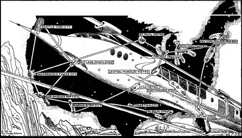
 [Image: The Super-Metropolis of 1975, via Paleo-Future; view larger!].
Yesterday, Paleo-Future pointed out a map from 1961, produced by the Chicago Tribune, in which the future urban landscape of the U.S. has been speculatively mapped – as it was projected to exist in the bright and futuristic year of 1975.
Ahead of its time in predicting the urban condition within which most of us now live, the map and its accompanying short article suggest that the “‘regional cities’ of tomorrow will be nearly continuous complexes of homes, business centers, factories, shops and service places. Some will be strip or rim cities; some will be star-shaped or finger-shaped; others will be in concentric arcs or parallels; still others will be ‘satellite towns’ around a nucleus core.”
Unfortunately, it gets the future of U.S. transportation all wrong:
They will be saved from traffic self-suffocation by high-speed transportation – perhaps monorails that provide luxurious nonstop service between the inner centers of the supercities, as well as links between the super-metropolises themselves.
Having ridden Amtrak somewhat extensively up and down the east coast, I would respectfully suggest that a different infrastructural future has come to pass.
Meanwhile, if you look at a bigger version of the map, you’ll see cities like the Chicago Crescent, the Michigan-Ohio Fingers, and Los Angeles Rim City – but it’s the sprawling urban complexes at the core of the country that seem so strangely interesting to me, like the Chattanooga Strip and the Central Missouri Metro, all linked together by arteries of high-speed rail.
What might a futuristic super-city in the hills and valleys of Tennessee really look like? What might a Mississippi mega-city really be?
(Via Paleo-Future, on a tip from James Petty).
Where is Denver and the whole front range grouping? Guess the map makers didn’t predict the growth here in the Denver area.
It is quite interesting to see the differences in urban development in the time since the image was produced. Notice that Atlanta is nowhere to be found because Atlanta had yet to hit the growth spurt that it did in the 80’s-2000.
Likewise, the New Orleans might have been on a map like this as late as 5 years ago but probably wouldn’t rate now that Katrina has effectively decimated the population numbers.
As for a Mississippi mega-city, one is already beginning to take shape on the Gulf Coast where it is almost possible to drive from New Orleans in the west to Mobile in the East without leaving a town. (Bay St. Louis, Diamondhead, Gulfport, Biloxi, Ocean Springs, Gautier, and Bayou LeBatre among the MS towns located along the relatively short distance between the cities) The flight of people from N.O. to nearby towns in response to Katrina has likely exacerbated the condition.
Many people on the coast live in one city and work in another city along the coast. If a high-speed rail were ever put into use along the coast it would certainly help make the area a more connected and singular population unit.
Atlanta does show up – its just part of the Chattanooga Strip (which is, north to south, Nashville, Chattanooga and Atlanta). That is a corridor that has been considered a good candidate for high speed rail. Perhaps by 2075…
I love looking at the way urban centres grow too – the way they fit into the landscape, the way they seem to depend on what is around them as if they themselves are a single living thing. I also like their names – nuclear, ribbon, dendritic. I don’t like them when they are planned. I like them to grow on their own.