Check the Sonic

[Image: From episode 9 of Patriot, courtesy Amazon Studios.]

This is incredibly random, and is perhaps indisputable evidence that I have fallen head over heels for mourning doves, but I’ve begun noticing, in the backgrounds of various films and TV shows, when mourning doves can be heard cooing—for example, in the new Doug Liman film, Locked Down, there is at least one scene where you can clearly hear a mourning dove singing in a London street.

Recall those recent acoustic studies of cities during the coronavirus lockdown that showed that, among other things, birds no longer had to struggle to be heard over the relentless noise of cars and industrial activity.

The Locked Down mourning dove was presumably a beneficiary of this larger acoustic change—yet it will never know it’s now an international celebrity! Maybe, if you live in London, you’ve even heard the same bird.

[Image: From episode 9 of Patriot, courtesy Amazon Studios.]

On the flipside of this, however, I was watching episode 9 of Amazon’s show Patriot the other night when I noticed the call of a Eurasian collared dove somewhere in the background, cooing in the woods. If the fictional setting of that scene is also where it was filmed, then this means Eurasian collared doves are alive and well in the forests of Wisconsin—an absurdly uninteresting point to raise if not for the fact that those doves are an introduced, invasive species.

It occurred to me, then, that you could potentially track invasive species—birds, insects, plants—by way of their unacknowledged appearance in the backgrounds of international film and TV projects.

Think of the scene in W. G. Sebald’s novel Austerlitz, where a character freezes a video and zooms in on a woman just barely visible in the background, concluding that he is, in fact, looking at the face of his own long-lost mother—indeed the only image he now has of her, this fleeting appearance in the shadows of a film that was actually about something else entirely.

Now imagine that on the scale of an entire ecosystem: a rarely seen bird flashes by behind a character in a blur of color and song, a single tree in a clearing beside two actors, its presence there indicating previously unnoticed changes in soil alkalinity or regional temperatures.

In other words, you could map the spread of invasive species, not to mention the effects of climate change, by noting what creatures pop up, however briefly, in the background of films shot in ecologically transitional regions of the world—an archive of climate effects and landscape futures hiding in plain sight, waiting to be noticed by the right researcher.

[Note: If you’re now desperate to see pictures of mourning doves, I’ve got you covered.]

Geomedia, or What Lies Below

[Image: Courtesy USGS.]

I love the fact that the U.S. Geological Survey had to put out a press release explaining what some people in rural Wisconsin might see in the first few weeks of January: a government helicopter flying “in a grid pattern relatively low to the ground, hundreds of feet above the surface. A sensor that resembles a large hula-hoop will be towed beneath the helicopter,” the USGS explains—but it’s not some conspiratorial super-tool, silently flipping the results of voting machines. It’s simply measuring “tiny electromagnetic signals that can be used to map features below Earth’s surface,” including “shallow bedrock and glacial sediments” in the region.

Of course, the fictional possibilities are nevertheless intriguing: government geologists looking for something buried in the agricultural muds of eastern Wisconsin, part Michael Crichton, part Stephen King; or CIA contractors, masquerading as geologists, mapping unexplained radio signals emanating from a grid of points somewhere inland from Lake Michigan; or a rogue team of federal archaeologists searching for some Lovecraftian ruin, a lost city scraped down to its foundations by the last Ice Age, etc. etc.

In any case, the use of remote-sensing tools such as these—scanning the Earth to reveal electromagnetic, gravitational, and chemical signatures indicative of mineral deposits or, as it happens, architectural ruins—is the subject of a Graham Foundation grant I received earlier this autumn. That’s a project I will be exploring and updating over the next 10 months, combining lifelong obsessions with archaeology and ruins (specifically, in this case, the art history of how we depict destroyed works of architecture) with an interest in geophysical prospecting tools borrowed from the extraction industry.

In other words, the same remote-sensing tools that allow geological prospecting crews to locate subterranean mineral deposits are increasingly being used by archaeologists today to map underground architectural ruins. Empty fields mask otherwise invisible cities. How will these technologies change the way we define and represent architectural history?

[Image: Collage, Geoff Manaugh, for “Invisible Cities: Architecture’s Geophysical Turn,” Graham Foundation 2020/2021; based on “Forum Romano, Rome, Italy,” photochrom print, courtesy U.S. Library of Congress.]

For now, I’ll just note another recent USGS press release, this one touting the agency’s year-end “Mineral Resources Program Highlights.”

Included in the tally is the “Earth MRI” initiative—which, despite the apt medical-imaging metaphor, actually stands for the “Earth Mapping Resource Initiative.” From the USGS: “When learning more about ancient rocks buried deep beneath the surface of the Earth, it may seem surprising to use futuristic technologies flown hundreds of feet in the air, but that has been central to the USGS Earth Mapping Resource Initiative.”

[Image: A geophysical survey of northwestern Arkansas, courtesy USGS.]

What lies below, whether it is mineral or architectural, is becoming accessible to surface view through advanced technical means. These new tools often reveal that, beneath even the most featureless landscapes, immensely interesting forms and structures can be hidden. Ostensibly boring mud plains can hide the eroded roots of ancient mountain chains, just as endless fields of wheat or barley can stand atop forgotten towns or lost cities without any hint of the walls and streets beneath.

The surface of the Earth is an intermediary—it is media—between us and what it disguises.

(See also, Detection Landscapes and Lost Roads of Monticello.)

Hospital Interiors / Dolby Suburbs

[Image: “Mix House” by Joel Sanders Architect, Karen Van Lengen/KVL, and Ben Rubin/Ear Studio].

Between cross-country moves, book projects, wild changes in the online media landscape over the past few years, and needless self-competition through social media, my laptop has accumulated hundreds and hundreds, arguably thousands, of bookmarks for things I wanted to write about and never did. Going back through them all feels like staring into a gravesite at the end of a life I didn’t realize was mortal.

For example, the fact that the scent of one of Saturn’s moons was created in a NASA lab in Maryland—speculative offworld perfumery—and that, who knows, it could even someday be trademarked. Or that mountain-front suburban homes in Colorado were unwittingly constructed over mines designed to collapse—and that of the mines have already begun to do so, taking surface roads along with them. Or the sand mines of central Wisconsin. Or the rise of robot-plant hybrids. Or the British home built around a preserved railway carriage “because bizarre planning regulations meant the train could not be moved”—a vehicle frozen into place through architecture.

In any case, another link I wanted to write about many eons ago explained that legendary producer and ambient musician Brian Eno had been hired to design new acoustics for London’s Chelsea and Westminster hospital, part of an overall rethinking of their patient-wellness plan. Healing through sound. “The aim,” the Evening Standard explained, “is to replicate techniques in use in the hospital’s paediatric burns unit, where ‘distraction therapy’ such as projecting moving images on to walls can avoid the need to administer drugs such as morphine.”

This is already interesting—if perhaps also a bit alarming, in that staring at images projected onto blank walls can apparently have the same effect as taking morphine. Or perhaps that’s beautiful, a chemical testament to the mind-altering potential of art amplified by modern electrical technology.

Either way, Eno was brought on board to “refine” the hospital’s acoustics, much as one would do for the interior of a luxury vehicle, and even to “provide soothing music” for the building’s patients, i.e. to write a soundtrack for architecture.

We are already in an era where the interiors of luxury cars are designed with the help of high-end acoustic consultants, where luxury apartments are built using products such as “acoustic plaster,” and where critical governmental facilities are constructed with acoustic security in mind—a silence impenetrable to eavesdroppers—but I remain convinced that middle-budget home developers all over the world are sleeping on an opportunity for distinguishing themselves. That is, why not bring Brian Eno in to design soothing acoustics for an entire village or residential tower?

Imagine a whole new neighborhood in Los Angeles designed in partnership with Dolby Laboratories or Bang & Olufsen, down to the use of acoustic-deflection walls and carefully chosen, sound-absorbing plants, or an apartment complex near London’s Royal Academy of Music with interiors acoustically shaped by Charcoalblue. SilentHomes™ constructed near freeways in New York City—or, for that matter, in the middle of nowhere, for sonically sensitive clients. Demonstration suburbs for unusual acoustic phenomena—like Joel Sanders et al.’s “Mix House” scaled up to suit modern real-estate marketers.

At the very least, consider it a design challenge. It’s 2020. KB Home has teamed up with Dolby Labs to construct a new housing complex covering three city blocks near a freeway in Los Angeles. What does it look—and, more to the point, what does it sound—like?

A Voice Moving Over The Waters

[Image: The Jim Creek Naval Radio Station from Popular Mechanics].

For a variety of reasons, I’ve been looking at a variety of large terrestrial antenna sites built for communicating with submarines. This is the field of Very Low Frequency (VLF) and Extremely Low Frequency radio transmission (the latter wonderfully abbreviated as ELF).

This is a topic already explored here several years ago, of course, with the Project Sanguine antenna field in Wisconsin, for example, and the Cutler array up on a peninsula in Maine. But a few other examples came up that I thought I’d post.

One is the example you see above: the Jim Creek Naval Radio Station in the woods of Washington State, as featured here in an old issue of Popular Mechanics. The Jim Creek facility is basically an entire valley in the Pacific Northwest, denuded of its trees and then strung with the harp-like cables of a mega-antenna. This antenna then broadcasts “the voice that crosses the Pacific,” as Popular Mechanics describes it, including U.S. military ships and submarines.

[Image: The antenna field at Jim Creek, via Wikipedia].

Briefly, although it’s technically irrelevant, it is nonetheless interesting in this context to read about the so-called “Hessdalen lights,” a phenomenon that appears to be caused by natural electrical currents moving through a remote Norwegian valley.

The scientific explanation for these “lights” is incredible.

Back in 2011, New Scientist reported, a scientific team “analyzed rock samples from Hessdalen and found that it is a valley of two halves: the rocks on one side of the Hesja river are rich in zinc and iron, those on the other are rich in copper. Then, during the 2012 mission someone mentioned an abandoned sulphur mine in the valley. ‘For me it was news,’ says [head scientist Jader Monari from the Institute of Radio Astronomy]. ‘We found zinc and iron on one side and copper on the other. If there is sulphur in the water in the middle, it makes a perfect battery.’”

By a weird fluke of geochemistry, the entire valley is a natural electrical cell! Now imagine a valley somewhere—in Washington State, say—acting as a giant natural radio transmitter: a geological radio station broadcasting signals out to sea.

In any case, here is the Jim Creek facility on Google Maps.

Two other quick things to mention: as a commenter pointed out here a few years ago, there is a spectacular naval-communications facility located on a peninsula in Western Australia called the Harold E. Holt Naval Communication Station.

[Image: Harold E. Holt Naval Communication Station, via Google Maps].

As described by the Australian government, the facility “consists of one central tower surrounded by two concentric circles each of six smaller towers ranging from 304 to 387 meters in height and is 2.54 km in diameter. It communicates over immense distances with submerged submarines in the Indian and Pacific Oceans.”

According to this commenter, the station “has an eerie suggestion of sacred geometry[:] pentagons and symmetrical shapes, all concentric. It is said that under the array, light bulbs held in the hand will glow.” This is not impossible; recall the work of artist Richard Box.

Indeed, seen on Google Maps, the facility is breathtaking. Be sure to zoom out to get a sense of how isolated this place is. Here is a view of the antennas from the nearby beach.

Finally, there is something called ZEVS. ZEVS is a secretive, Soviet-era electromagnetic facility and submarine-communication antenna array that allegedly exists somewhere beneath the forests of the Kola Peninsula.

There’s not a ton of information about it online, but I’m also just lazily Googling things at the moment and have undoubtedly missed something; if you have more details, by all means please feel free to share.

Abandoned Basements as Stormwater Basins

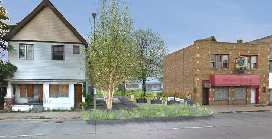
[Image: Rendering of a possible “BaseTern” landscape by students Brett Harris, Andrew D’Arcy, and Heidi Petersen, via Landscape Architecture Magazine].

Not all the news coming out of Milwaukee involves misguided highway megaprojects or tax-funded crony capitalism—though there is that.

For example, Wisconsin governor Scott Walker—confusing an earlier generation’s urban mistakes with how a city is meant to function—has been plowing billions of dollars’ worth of taxpayer money into “freeway megaprojects” for which “the pricetag got so big that leaders from his own party rejected his plan as fiscally irresponsible, leaving the state budget in limbo,” Politico reports:

As the state has shifted resources into freeway megaprojects, 71 percent of [Wisconsin’s] roads are in mediocre or poor condition, according to federal data. Fourteen percent of its bridges are structurally deficient or functionally obsolete, which is actually better than the national average. Walker and his fellow Republicans have killed plans for light rail, commuter rail, high-speed rail, and dedicated bus lanes on major highways, so there is almost no public transportation connecting Milwaukee to its suburbs, intensifying divisions in one of the nation’s most racially, economically and politically segregated metropolitan areas. Yet Walker, who is running for president as a staunch fiscal conservative, has pushed a $250 million-per-mile plan to widen Interstate 94 between the Marquette and the Zoo despite fierce local opposition.

If that sounds both avoidable and unfortunate, consider the fact that “Walker also killed a ‘Complete Streets’ program that pushed road builders to accommodate bicyclists and pedestrians.”

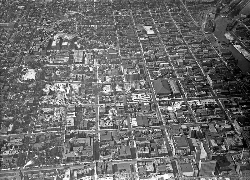
[Images: (top) Milwaukee’s Marquette interchange, nearly the same size as the city it cuts through; (bottom) Milwaukee before the interchange. Images via Politico].

At the same time, Walker has also “championed a high-profile proposal to spend a quarter of a billion dollars of taxpayer money to help finance a new Milwaukee Bucks arena—all while pushing to slash roughly the same amount from state funding for higher education,” the International Business Times reports.

But, hey, why does Wisconsin need universities when everyone can just go to an NBA game? Not that benefitting the public is even Walker’s goal: “One of those who stands to benefit from the controversial initiative is a longtime Walker donor and Republican financier who has just been appointed by the governor to head his presidential fundraising operation.”

In any case, an interesting landscape test-project is currently underway in Milwaukee, called the “BaseTern” program.

As the city explains it, a “BaseTern” is “an underground stormwater management or rainwater harvesting structure created from the former basement of an abandoned home that has been slated for demolition.” Why is the city doing this?

By using abandoned basements, the City saves the cost of demolition on these structures (filing the basement and grading the surface) and on excavation for the new structure. In addition, BaseTerns provide significant stormwater storage capacity on a single site, the equivalent of up to 600 rain barrels.

The result, the city is keen to add, is “not an open pit. Rather a BaseTern is a covered structure, which is covered with topsoil and grass, and will appear the same as conventional vacant lot.”

In their July 2015 issue, Landscape Architecture Magazine explained that this is, in fact, “the world’s first such system.” Conceived—and actually trademarked—by a city official named Erick Shambarger, the idea was inspired by a GIS-fueled discovery that the worst flooding in the city always “occurred in neighborhoods with high rates of foreclosures. The city controls roughly 900 foreclosed properties, many of which it plans to demolish. Shambarger figured the city could preserve the basement structure and put it to use.”

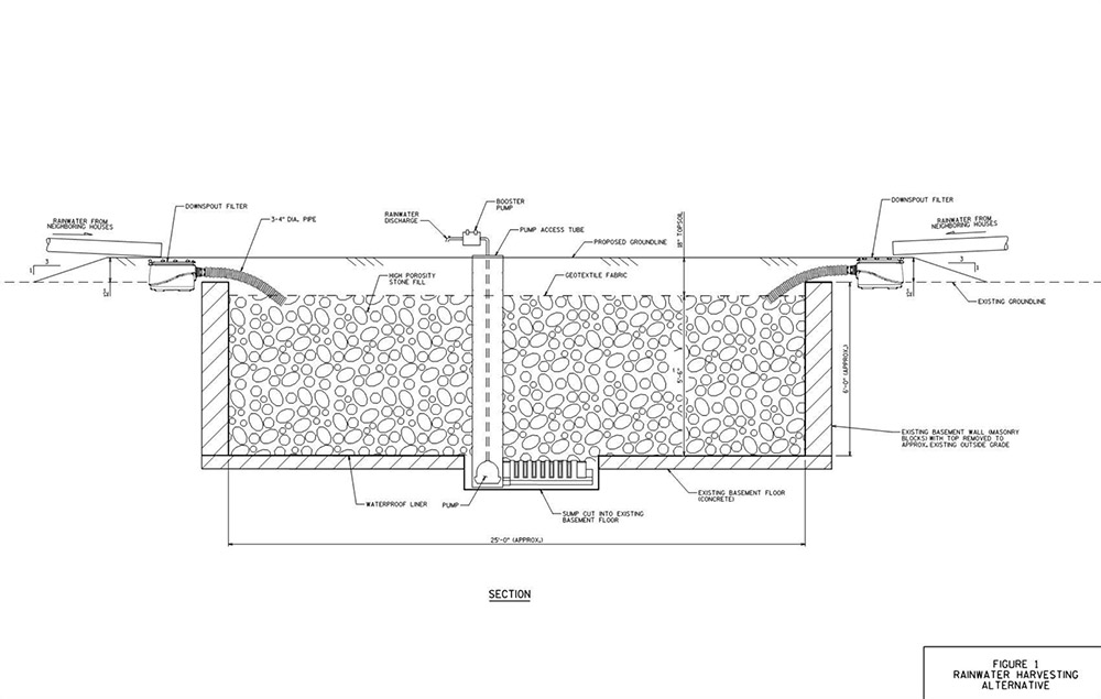
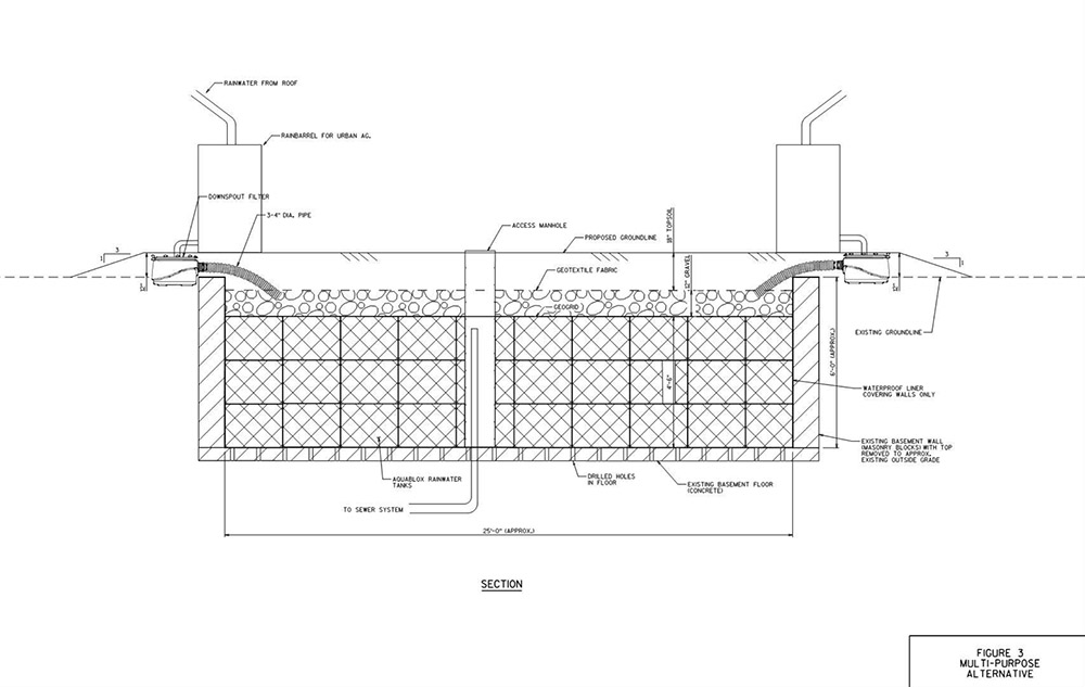
[Images: Two BaseTern design diagrams, taken from Milwaukee’s “Vacant Basements for Stormwater Management Feasibility Study“].

While there is something metaphorically unsettling in the idea that parts of a blighted, financially underwater neighborhood might soon literally be underwater—transformed into a kind of urban sponge for the rest of Milwaukee—the notion that the city can discover in its own economic misfortune a possible new engineering approach for dealing with seasonal flooding and super-storms is an inspiring thing to see.

The BaseTern program also potentially suggests a stopgap measure for coastal cities set to face rising sea levels well within the lifetimes of the coming generation.

In the all but inevitable managed retreat from the coast that seems set to kick off both en masse and in earnest by midcentury—something that is already happening in New York City, post-Sandy—perhaps the subterranean ruins of old neighborhoods left behind can be temporarily repurposed as minor additions to a broader coastal program intent on reducing flooding for residents further inland.

Before, of course, those underground voids—former guest bedrooms, dens, man caves, she sheds, and basements—are inundated for good.

Read more about BaseTerns over at Landscape Architecture Magazine.

Project Sanguine and the Dead Hand

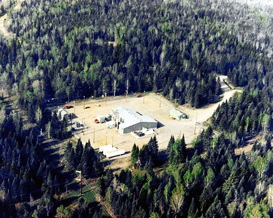
[Image: One of the stations of Project ELF, via Wikipedia].

Further exploring the radio-related theme of the last few posts, Rob Holmes—author and co-founder of mammoth—has pointed our attention to something called Project Sanguine, a U.S. Navy program from the 1980s that “would have involved 41 percent of Wisconsin,” turning that state into a giant “antenna farm” capable of communicating with what Wikipedia calls “deeply-submerged submarines.”

Each individual antenna would have been “buried five feet deep” in the fertile soil of the Cheese State, the New York Times explains, creating a networked system with nearly 6,000 miles’ worth of cables and receiving stations.

The Navy was hoping, we read, for a system “that could transmit tactical orders one-way to U.S. nuclear submarines anywhere in the world, and survive a direct nuclear attack.” This would “normally… require an antenna many hundreds of miles in length,” according to the NYT, but Naval strategists soon “realized that a comparable effect could be achieved by using a large volume of the earth’s interior”—that is, “looping currents deep in the Earth”—”as part of the antenna.” The hard and ancient rock of the Laurentian Shield was apparently perfect for this.

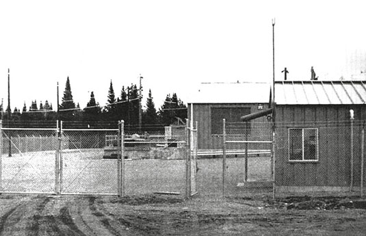
[Image: From Roy Johnson, “Project Sanguine,” originally published in The Wisconsin Engineer (November 1969)].

In other words, the bedrock of the Earth itself—not a mere island in the Antarctic—could be turned into a colossal radio station.

A similar system, installed for preliminary tests in North Carolina and Virginia, “apparently flickered lightbulbs in the area and caused spurious ringing of telephones,” like some regional poltergeist or a technical outtake from Cabin in the Woods.

At least two things worth pointing out here are that a “scaled-down version” of Project Sanguine was, in fact, actually constructed, becoming operational in the northern forests of Michigan and Wisconsin from 1989-2004; called Project ELF (for Extremely Low Frequency), it arrived just in time for the Soviet Union to collapse…

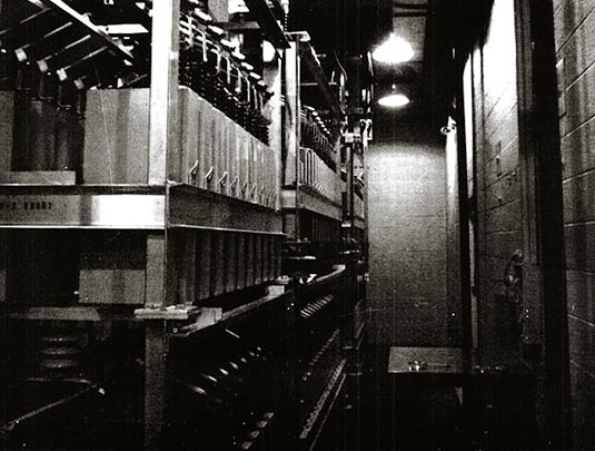
[Image: Inside Project Sanguine; photo from Roy Johnson, The Wisconsin Engineer (November 1969)].

…which brings us to the second point worth mentioning: a strangely haunting program known as “The Dead Hand,” a doomsday device constructed by the Soviet Union.

In his Pulitzer Prize-winning book of that title, historian David Hoffman writes about a (still active) weapon of retaliation. The “Dead Hand” was built such that, if nuclear field commanders ever lost touch with military leaders back in Moscow during a time of war, a constellation of cruise missiles would automatically launch. This would happen not in spite of a lack of living military leaders, but precisely because everyone had been killed. That is, a machine would take over—thus the name “dead hand.”

Each cruise missile, however, flying over the lands of the USSR, would emit launch commands to all of the missile silos it passed over. Missile after missile would soon soar—thousands of them—arcing toward the United States, which would soon be obliterated, along with the rest of the world, in a nuclear holocaust controlled and commanded by nothing but preprogrammed machines.

In any case, Project Sanguine was its own version of an end-times radio, an “immense subterranean grid” transmitting to distant submarines by way of the Earth itself, humans using an entire planet as an apocalyptic radio device.